
GLOSSARY: In support of ...
BLUEPETE'S HISTORY OF NOVA SCOTIA:
| A | B | C | D | E | F | G | H | I | J | K | L | M | [HISTORY JUMP PAGE] | |
| N | O | P | Q | R | S | T | U | V | W | X | Y | Z |
-
(Click on letter to go to index.)
-A-
- Acadia, Population Levels of Old ...:
- Acadia, Transport Ships of the Acadian Deportation (1755):
- Admiralty Court: (Under Construction.)
-
(Click on letter to go to index.)
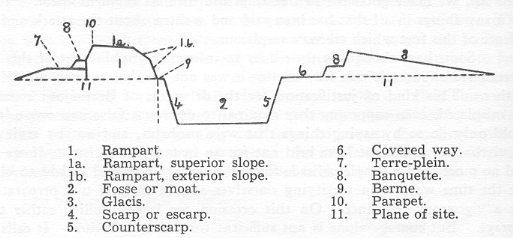
-B- - Bastion:
- A Bastion is a projecting part of a fortification, consisting of an earthwork, faced with brick or stone, or of a mass of masonry, in the form of an irregular pentagon, having its base in the main line, or at an angle, of the fortification; its flanks are the two sides which spring from the base, and are shorter than the faces or two sides which meet in the acute salient angle.
- Blendheim (1704):
- Boyne, Battle of the ...:
- [See Glorious Revolution.]
- Brigantine:
- [See Sailing Vessels of the 18th Century..]
- Byng, John:
- [See Minorca.]
-
(Click on letter to go to index.)
-C- - Cape Finisterre:
- On May 14th, 1747, off the Atlantic coast of Spain, Cape Finisterre, a British fleet of 16 warships under Anson came upon a French supply fleet under escort; shortly thereafter, a very famous naval battle was to unfold leading to the surrender of the French admiral, La Jonquière; and, glory for Anson. Anson had with him, as second in command, Peter Warren, the naval hero of "The First Siege of Louisbourg (1745). Also present, as the captain of the 74 gun Namur, was Boscawen, who lead the English naval fleet during The Second Siege of Louisbourg (1758). La Jonquière was on his way to Quebec with many of those who had been deported to France by the English after the French surrendered Louisbourg in 1745. The French fleet consisted of 16 warships, 22 transports, and six East Indiamen. In the DCB, we see written that the odds were much in the favour of the English ("the French could line up only 312 guns against 978 for the British"; vol. iii, p. 610). I wonder about this; as the English and the French were matched as to the number of war ships. The French, notwithstanding they lost the battle, did carry out their duty and held all of their charges safe: the English did not get at the supply ships; they were able to get away and get to their destinations, unmolested. In any event, the English and the French men-of-war pounded away at one another for five hours. Jonquière's ship, the 64-gun Sérieux, had five English ships pouring tons of shot into her; 140 members of her crew were ether killed or wounded, indeed, Jonquière was wounded. In 1749, La Jonquière, incidently, after having spent two years in England as a prisoner of war, with the arrival of "peace," finally was to take up his gubernatorial duties at Quebec during the summer of 1749.
- Careen:
- [See Sailing Vessels of the 18th Century..]
- Casemate:
- In a fortification, a vaulted chamber built in the thickness of the ramparts of a fortress, with embrasures for the defence of the place; a bomb-proof vault, generally under the ramparts of a fortress, used as a barrack, or a battery, or for both purposes.
- Le Chameau.
- Corvette:
- [See Sailing Vessels of the 18th Century.]
- Covered Way:
- (See diagram under rampart.)
- Culloden.
-
(Click on letter to go to index.)
-D- - Date:
- For the English, in 1752, there was a change in the way they dated things; it brought the country in to line with the dating system of other nations. I quote Trevelyan [England Under Queen Anne, vol. 2, preface, p. x.]: "Until 1752 the English at home always used the Old Style, after 1700 eleven days behind the New Style of Gregory XIII's Calendar, which was current in all continental countries except Russia. Our sailors, on service at sea and on coast operations like the taking of Gibraltar, generally used the Old Style familiar at home. Our soldiers in the Netherlands and Spain generally but not always used the New. Diplomats abroad most of them used the New, but some the Old." Further, it is to be noted that under the Old Style dating system, the new year started on March 25th and not January 1st. Most modern history writers, however, will use January 1st as the turn over for the new year.
- Dettington, Battle of ...:
- See note in the biographical write on Robert Monckton.
- Dysentery:
- "A disease characterized by inflammation of the mucous membrane and glands of the large intestine, accompanied with griping pains, and mucous and bloody evacuations." (OED.)
-
(Click on letter to go to index.)
-E- - Embrazure:
- An embrazure is much like a window or door through a wall. It is a gap or loophole, left open in a fortified wall so that a gun may be fired through it at the enemy outside of the walls. The sides of the embrazures, the jambs, are usually slanted or beveled, so that the inside profile of the opening is larger than that appearing on the outside of the wall. Such a spreading or embrasure of the jambs increases the opening inwards. An opening that leaves but just room for the muzzle to poke through and that widens as it comes in through the wall to the interior, allows a crew to work with the gun and yet leaves the least amount of exposure to the enemy beyond the walls.
-
(Click on letter to go to index.)
-F- - Fascine:
- A long cylindrical faggot of brush or other small wood, firmly bound together at short intervals, used in filling up ditches, the construction of batteries, etc.
- Fighting Fortieth (1697-1762):
- Firkin:
- "A small cask for liquids, fish, butter, etc., originally containing a quarter of a barrel ..."
- Fontenoy, Battle of ...:
- See note in the biographical write on Robert Monckton.
- Flûte:
- [See Sailing Vessels of the 18th Century..]
- Frigate:
- [See Sailing Vessels of the 18th Century..]
-
(Click on letter to go to index.)
-G- - Glacis:
- A glacis is a gently sloping bank, which in fortifications, extends from the parapet of the covered way to meet the natural surface of the ground. (See diagram under rampart.)
- Gabion:
- A wicker basket, of cylindrical form, usually open at both ends, intended to be filled with earth, for use in fortification and engineering.
- Glorious Revolution (1688):
- Gordon Riots:
- The Gordon Riots were named after Lord Gordon Gordon (1751-93). At the age of 23, doubtlessly occupying a family seat, Lord Gordon was to become a Member of Parliament. His record apparently shows that he was quite ready to attack all sides. He was much against the political rehabilitation of Roman Catholics; though, there was a movement -- at long last -- to allow Catholics to come back into the political mainstream. In 1778, legislation was passed to restore certain political rights to Catholics. The response that Lord Gordon had was to go to the streets and work up the mobs. On June 2nd, 1780, a mob of 50,000 Londoners marched in procession to the House of Commons crying for repeal. A riot broke out which was to last five days during which time Catholic chapels and private homes were destroyed. Other houses of public officials were destroyed including the house of the Chief Justice, Lord Mansfield. On the 7th of June the troops were called out and 285 of the rioters were reportedly killed. Lord Gordon himself was tried for high treason, but he was to have a famous champion for a lawyer, Erskine, and, Gordon was acquitted. His acquittal was not to bring him any peace and I note that things, thereafter, were to go badly for him. In 1793, Lord Gordon died in prison (Newgate) having been put there on account of a libel on Marie Antoinette.
- Grenadiers
- Guns
-
(Click on letter to go to index.)
-H- - The Huguenot:
- Hogshead:
- A hogshead is a large cask for the storage and transportation of liquids and commodities. Abbreviated, hhd. Though its capacity did vary from country to country to one degree or another, the London hogshead of beer contained 54 gallons. Thus, the standard measure was around 50 gallons, for most liquids; but it could vary to a great degree, for example, a hogshead of molasses was, in 1749, fixed at 100 gallons. They were useful empty as well as full: Hogsheads fill'd with Earth served to make Breast-works, to cover the Men. "Innumerable fascines, and hogsheads, and trunks of trees, were heaped on each other." (Gibbon.) (See also pipe; for barrels, their sizes and use, see David E. Stephens' article, "Forgotten Trades of Nova Scotia" in NSHQ#2/1.)
-
(Click on letter to go to index.)
-I- - Immigrant Ships: The Arrrivals At Halifax, 1750-52:
- Indians:
- See The Micmac of Megumaagee.
-
(Click on letter to go to index.)
-J- - Jacobites:
- Justices of the Peace:
- In the days under review, there was a distinct lack of legally trained people; yet, there was as great a need, as ever, for appointed individuals to adjudicate and to settle civil disputes. An upstanding member of the community would be appointed and charged with the duty to keep the peace in the area named. "Their principal duties consist in committing offenders to trial before a judge and jury when satisfied that there is a prima facie case against them, convicting and punishing summarily in minor causes, granting licenses, and acting, if County Justices, as judges at Quarter Sessions." (OED.) "Police work, petty justice, the poor law, and every function of local government" depended upon the justices of the peace. (Trevelyan's England Under Queen Anne vol. 1, p. 101.) Trevelyan, in another work of his, English Social History at p. 353, "... generally speaking the Justices who did most of the work in rural districts were substantial squires, too rich to be corrupt or mean, proud to do hard public work for no pay, anxious to stand well with their neighbours, but often ignorant and prejudiced without meaning to be unjust, and far too much a law unto themselves." With the passage of the County Council Act, 1888, the administrative functions of the Justices of the Peace were eliminated; rural magistracy came to an end in England. (Trevelyan's England Under Queen Anne, p. 100.) The system was followed in Canada in the old days; but, it no longer exists (pity).
-
(Click on letter to go to index.)
-K- -
(Click on letter to go to index.)
-L- - Letter of Marque:
- Letters of marque (and reprisal), a licence, would be granted to appropriate subjects by both sides in a time of war. It was "a licence to fit out an armed vessel and employ it in the capture of the merchant shipping belonging to the enemy's subjects, the holder of letters of marque being called a privateer or corsair, and entitled by international law to commit against the hostile nation acts which would otherwise have been condemned as piracy." (OED.)
- Louisbourg Fleet (British): 1745.
- Louisbourg Fleets: 1758.
- Louisbourg Regiments: 1758.
-
(Click on letter to go to index.)
-M- - Malicite Indians: (See The Micmac of Megumaagee.)
- Men-of-War at Louisbourg, 1745:
- The Twelve British War Ships who participated in the First Siege Louisbourg.
- Micmac of Megumaagee:
- Minorca:
- In May of 1756, Admiral John Byng (1704-57) of the British navy failed to engage the French fleet at Minorca in the Mediterranean in a manner which might have been approved by the British Admiralty. Admiral, or no, Byng was brought back to England under arrest, court marshaled and found guilty. His sentence: he was brought down to Portsmouth and was ceremoniously shot dead on the quarter deck of one of his ships, the Monarque.
- Mississippi Joint Stock Company:
- On September 6, 1720, the formation of the Mississippi Joint Stock Company was entered into the registers at Paris, setting up "crazed speculation" in the streets of Paris for a period of five years when the whole fantastic scheme came tumbling down at considerable expense to the French, especially the forced, imprisoned, and famished settlers at the new French colony in Louisiana. This early and disastrous stock promotion came about as the result, not of a Frenchman, but of a man from Scotland, John Law (1671-1729). John Law was originally from Edinburgh, the son of a goldsmith and banker. He went to Paris and convinced the authorities that paper money was the answer to the French government's need to finance its royal spending habits. "In 1719, Law originated a joint stock-company for reclaiming and settling lands in the Mississippi valley, called the Mississippi scheme." (Chambers.) Law proposed and tried to set up "a prodigious system of credit, of which Louisiana, with its imaginary gold mines, was made the basis. The government used every means to keep up the stock of the Mississippi Company. It was ordered that the notes of the royal bank and all certificates of public debt should be accepted at par in payment for its shares. Powers and privileges were lavished on it. It was given the monopoly of the French slave-trade, the monopoly of tobacco, the profits of the royal mint, and the farming of the revenues of the kingdom. Ingots of gold, pretending to have come from the new Eldorado of Louisiana, were displayed in the shop-windows of Paris. The fever of speculation rose to madness, and the shares of the company were inflated to monstrous and insane proportions." (See Parkman, A Half Century of Conflict (vol. 1), pp. 315-6.)
-
(Click on letter to go to index.)
-N- - New Style Date:
- See Date.
-
(Click on letter to go to index.)
-O- - Old Style Date:
- See Date.
(Click on letter to go to index.)
-P-- Parapet:
- A parapet is "a defence of earth or stone to cover troops from the enemy's observation and fire; in permanent works, a protection against shot, raised on the top of a wall or rampart; in field-works, a bank of earth high enough to screen the defenders and thick enough to resist any shot that is likely to be discharged against it. spec. a bank of earth in front of a military trench." (See diagram under rampart.)
- Pinnace:
- [See Sailing Vessels of the 18th Century..]
- Pipe:
- A pipe is such a cask with its contents (wine, beer, cider, beef, fish, etc.), or as a measure of capacity, equivalent to half a tun, or 2 hogsheads, or 4 barrels. Like so many of the old measurement terms, there was no standard and it varied for different commodities; but, it was usually 105 imperial gallons.
- Population Levels of Old Acadia:
- Population Levels of Louisbourg:
- Press Gang:
- Prize Money:
- In times of war the British navy, its officers and men, had an extra inducement to take enemy ships and their cargo. Captured ships and their cargo would be brought to a port which had a Court of Admiralty where the matter would be judged and decreed that the ship and cargo were a prize of war and to be sold with the proceeds to be Droits of the Crown, or of the Admiralty; as such, it was to be all given over to those responsible for the capture. The money was "divided into eighths, of which three went to the captain, one to the commander-in-chief, one to the officers, one to the warrant officers, and two to the crew." This system of prize money was long in place and certainly covered the period with which we are concerned about, indeed it was in place for the British during the Second World War. (Oxford Companion to Ships & the Sea.)
-
(Click on letter to go to index.)
-Q- - Quintal:
- A weight of one hundred pounds; a hundred-weight (112 lbs.).
-
(Click on letter to go to index.)
-R- - Rampart:
- A mound of earth raised for the defence
of a place, capable of resisting cannon-shot, wide enough on the top for
the passage of troops, guns, etc., and usually surmounted by a stone
parapet.
- Rated War Ships:
- [See Sailing Vessels of the 18th Century..]
- Regiments, Louisbourg: 1758.
-
(Click on letter to go to index.)
-S- - Sally:
- To issue suddenly from a place of defence or retreat in order to make an attack.
- Sallyport:
- An opening in a fortified place for the passage of troops when making a sally. Sallyports were not peculiar to land forts, for instance a sallyport could be found on each quarter of a fire-ship, out of which the officers and crew make their escape into the boats. Also, one entered into a three-decker through a sallyport. Usually sally ports were always locked up and only opened up by special permission.
- Sailing Vessels of the 18th Century:
- Scurvy:
- Smallpox:
- Souriquois Indians:
- See The Micmac of Megumaagee.
-
(Click on letter to go to index.)
-T- - Tea:
- By 1720, great quantities of tea was making its way to the docks at London. "The China drink" had made its introduction to English tables as early as 1657. By 1720, tea was driving business in London and exploration abroad. With the general expansion of trade after 1713 the growth was more rapid. In Great Britain, we see, the annual import rose from 121,000 lbs. in 1715 to 238,000 lbs. in 1720. Tea was not near as popular in the milder climates of the southern European states. The French, nonetheless, got in on the profitable tea trade, mainly, I suggest, because, ever since 1689 the English customs duties on tea had been absurdly high. It would appear the French were illegally supplying the tea drinkers in Britain. Smuggling was a big business in the English Channel islands. In the early days most of the tea came from China, though we see that the French did establish plantations in the West Indians. It was to be 1839, before the 19th century tea trade with India took off.
- Tierce:
- "An old measure of capacity equivalent to one third of a pipe (usually 42 gallons old wine measure, but varying for different commodities: cf. pipe); also a cask or vessel holding this quantity, usually of wine, but also of various kinds of provisions or other goods (e.g. beef, pork, salmon, coffee, honey, sugar, tallow, tobacco); also such a cask with its contents." (OED)
- Tories (See under Whigs):
- Typhus:
- "An acute infectious fever, characterized by great prostration and a petechial eruption; chiefly occurring in crowded tenements, etc." (OED.) "Petechial eruption" is the eruption of petechia, or small red or purple spots in the skin caused by extravasation of blood. It has many names down through history, including: Camp Fever, Jail Fever, Hospital Fever, and Ship Fever. Typhus is believed to be spread by a parasitic insect, the typhus-louse.
-
(Click on letter to go to index.)
-U- -
(Click on letter to go to index.)
-V- -
(Click on letter to go to index.)
-W- - Whigs:
-
(Click on letter to go to index.)
-X- -
(Click on letter to go to index.)
-Y- -
(Click on letter to go to index.)
-Z-
http://www.blupete.com/Hist/Gloss/Glossary.htm
---------------------
-
- "Scottish Immigration Into Nova Scotia"

"From the lone Shieling
of the misty island
Mountains divide us,
and the waste of seas --
Yet still the blood is strong
the heart is Highland,
And we in dreams
behold the Hebrides.1
>>>>>>>>>>>>>>>>>>>>>>>>>>>>>>>>
GO TO TABLE OF CONTENTS.
- Introduction
- The Highlander
- Post-Culloden
- Scottish Clearances
- Immigration To Nova Scotia
- Scottish Immigration To Cape Breton
- Conclusion
- Notes
- Authorities
[TOC]
Introduction The great English essayist, Macaulay wrote of them: "In perseverance, in self-command, in forethought, in all the virtues which conduce to success in life, the Scots have never been surpassed." Further, it might be said, that the Scots were a race in whom personal and family pride was the dominant passion. These attributes might well describe the Lowlanders and the Highlanders; though, there was a considerable difference of another kind between them, especially before the mid-18th century.2
Defoe described the Highlander:
"They are formidable fellows and I only wish Her Majesty had 25,000 of them in Spain [the British and the Spaniards were at war], as a nation equally proud and barbarous like themselves. They are all gentlemen, will take affront from no man, and insolent to the last degree. But certainly the absurdity is ridiculous to see a man in his mountain habit, armed with a broadsword, target, pistol, at his girdle a dagger, and staff, walking down the High Street as upright and haughty as if he were a lord, and withal driving a cow!"3
The Scots who came to Nova Scotia during the last half of the 18th and first half of the 19th century were Highlanders.4 They came to the shores of Nova Scotia, and, unlike many other immigrants that also came during this time, the Highlanders stuck and generally did not bleed away to other parts.5 Truly, Nova Scotia, especially that of Cape Britain, reminded the new arrivals of their native land, the Highlands of Scotland. They found the same looking land and soil; the same weather; and, in time, the same people (their brethren who had arrived earlier). It was not likely the only reason which drove families to relocate over the seas, but it is accepted that it was the land clearances in Scotland that drove the Highlanders to America. With the approval of those in the highest positions of government (then located in London) fences went up where fences had not been. Fences were needed to mark-off individual property rights; and these rights had finally come to Scotland ending the feudal system which had long lasted in Scotland. Prior to this "English" fencing there were, quite unlike what one sees today, no hedges; all about were open fields. These fields were cultivated, but strictly according to "village rules of immemorial antiquity." No one owned these common fields. Thus these fields, once available to the common people, were enclosed and large farms appeared. This process was part of a general revolution in society which had begun many years before in Europe and only lastly came to Scotland. The total effect of the unfolding process was likely, on the whole, good for Scotland.6
This process just briefly described, principally, led the Highlanders to immigrate to North America, with Nova Scotia getting, to her good fortune, more than her share of Highlanders.
[TOC]
The Highlander
The view had by the typical Englishmen of the Scottish highlander, a view, incidental, held by the mighty Roman army when it was in possession of most of the British Isles7 was expressed by the historian, G. M. Trevelyan:
"Beyond the Highland line ... lay the grim, unmapped, roadless mountains, the abode of the Celtic tribes, speaking another language; wearing another dress; living under a system of law and society a thousand years older than that of Southern Scotland; obedient neither to Kirk nor Queen, but to their own chiefs, clans, customs and superstitions. Till General Wade's work a generation later, there was no driving road through the Highlands. Nature reigned, gloomy, splendid, unchallenged ..."8
In 1724, the English decided that they would attempt to control these wild men to the north of them.9 They sent an army officer, George Wade to inspect Scotland. He reported back that what was needed was a permanent presence of the British Army. There should be forts and barracks built for British soldiers and to connect them up by proper roads. In the result, Wade was appointed as the commander for these northern regions and tasked with carrying out his own recommendations. Between 1725 and 1737 Wade directed the construction of some 250 miles of road and 40 bridges. This British military activity, worked. The Celtic tribes, their chiefs, clans, customs and superstitions, if not ended permanently, changed in 1745 with the Battle of Culloden.
"Although a fraction only of the clans had taken part in the last Jacobite Rebellion of 1745, all felt the results of its defeat. Bayonet and noose, the prescription of arms, of tartan and kilt, the abolition of the hereditary jurisdictions of the chiefs, the sequestration of their estates, began the destruction of the clan system. A memory survived, cocooned in the silk of songs, awaiting mutation in romance."10
The survived memory to which John Prebble referred was firmly in the minds of all highlanders and most certainly of those that came to the shores of New Scotland, Nova Scotia. [TOC]
Post-Culloden
After Culloden a distinctive era for Scotland came to an end and another began. It put an end to the claims of the Stuarts and it solidified the Hanoverian hold on the English throne. These were important objectives for those in power at the time, and the reason why the English troops under Cumberland did such a thorough job of it in northern Scotland. More important to history, is that in the aftermath of Culloden the clan structure of Scotland, which had been the last bastion of European feudalism came to an end. An entire new structure, of leadership and of law, was put in place which shook Scotland to its very roots.
To disperse the people of these Scottish clans became the objective of the English. A view became popular that it might be best if the Scottish rebels were shipped off to America. Admiral Peter Warren, in a dispatch to the Board of Trade dated July 10th, 1746, wrote: "Fones is just arrived here [Boston], and brings us the agreeable account of his royal highness' success [Culloden] against the rebels. I hope the government will hang every chief among them that can write or read, and send the rest to be dispersed through the American colonies!"11
More generally, hard times came to Great Britain in the wake of the Napoleonic wars (1793-1815). The lower classes became poverty stricken. The people who inhabited the Highlands of Scotland were always poor, in the years beyond 1815, more so. The authorities thought to relieve the developing problems by supporting schemes that would reduce population levels by shipping poor Scottish people to America. And so it came to be, that from 1815 to 1830 there was a steady stream of immigrants from Scotland many of whom came to Nova Scotia.
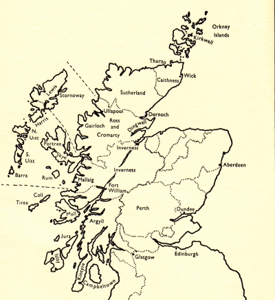
It is important to emphasize that the greatest number of Scottish immigrants came to Nova Scotia during the first half of the 19th century, in the wake of the Napoleonic Wars (1793-1815). In my work, Settlement, Revolution and War, I wrote of the earlier arrivals, especially those that arrived at Pictou on the Hector in 1773, the first ship to come to Nova Scotia directly from Scotland in the 18th century. The Hector was but one of a very limited number of immigration ships that arrived at Pictou in the 18th century. It is estimated that there may have been four, which is a number that pales to the number that arrived after the 19th century had begun.
The Scottish people who arrived on the Hector were Presbyterian from Sutherland (see map). They stayed on in the Pictou area joining the English speaking Protestants who had come from Pennsylvania in 1767. In the years after, the Scottish arrivals at Pictou settled in the area, but not all. If they were Presbyterian they tended to stick but the Catholics were encouraged to move on to Antigonish County and Cape Breton. Eventually, but not before 1802, Scottish settlers came directly from Scotland to Cape Breton.12 "Highland immigration to Cape Breton reached its peak in 1828, but it continued until the 1850s. Soon the Highlanders outnumbered all other ethnic groups in Cape Breton and both the eastern counties of Pictou and Antigonish."13
An analysis of the population levels in Cape Breton through the years 1817-1838, though no passenger lists survive, show that the Scottish Immigration was heavy.14 It appears that thousands of poor Scottish people came to the island. As of 1817, the population of Cape Breton was between 7,000 and 8,000; as of 1827 it was at 18,700; as of 1838 it was at around 38,000. The increase from 1817 to 1838 was approximately 30,000 mostly due to the influx of Highland Scots.15
The principal reason why these people were driven from their homelands, as the historians have labeled it, was because of the Scottish Clearances.
[TOC]
Scottish Clearances
It is not difficult to find people who will say it was the "Land Clearances" that drove the Highlanders from their ancient home grounds to Nova Scotia. This was likely part of why so many left their homes during this period, particularly between 1815 to 1830. Like so many phenomena that impact on human affairs, it is often difficult to point to causes that brought on a particular train of events. Certain of these causes can go back along time and are likely pinned to the culture of the people effected. This would be especially so, where a law is introduced, such as private property rights, to a land and culture which did not know of or depend upon such extensive rights.
"For the age of enclosure was also the age of new methods of draining, drilling, sowing, manuring, breeding and feeding cattle, making of roads, rebuilding of farm premises and a hundred other changes, all of them requiring capital."16 Trevelyan continues and points out that this movement started in the early part of the 18th century, much before Culloden, as the "rustic squires" with their smaller acreages gradually disappeared in favour of a growing landlord class who had the capital and credit for large agricultural operations.
Prior to the clearances, villages, a small collection of people, as were all villages of medieval times, were surrounded by open fields to be used by all and owned by the community as a whole. And so, between the years 1760 and 1840, "open fields" were abolished by acts of parliament and titles of ownership placed in the hands of a few who had won favour with the crown. Some good came of it; some bad.
"The inclosure movement had increased the amount of land in the hands of the upper and wealthy classes; the more enterprising small freeholders became large farmers, the weaker and poorer men sank into the status of labourers at a time when, owing to the increase in the rural population, there was already a drift of the labouring class into the towns. ... The labouring families, in areas of recent and considerable inclosure, lost their customary privileges of stubbling on open fields or putting a beast on the commons. The loss of fuel was also a hardship at a time when timber was scarce. ... The diet of most labouring families was bread and cheese for six out of seven days of the week, though some labourers kept a pig, and many had small gardens. It is difficult enough, on these low standards, to make any comparison with earlier times. On the whole, taking into account all sources of income, the average labourer was probably not worse off in the ten or twenty years after 1815 than he had been in 1790 ..."17
The "Clearances, no doubt, brought great changes to the way of life for the ancient Scottish clans. They were never quite farmers, nor fisherman: they were "semi-nomadic herdsmen." During the summer months the males would go off to mind their herds, leaving their cottages and families behind. Their herds would be cut back for the winter months with sales being made to the drovers.18 The sea did provide, however, some cash income. They gathered kelp along the shore, dried it, and burnt it for the resultant alkaline ash (potash) for which there was a great and growing demand during the late 18th century due to numerous manufacturing processes which were then being employed. For quite some period of time, "in Lewis and the Uists there were no songs sung about a land taken from the people, or of white-sailed ships taking away the best of the youth."19 The reason that Prebble gives, is, because the islands were profitable enough without sheep: they could harvest kelp from the sea. It is burnt for the sake of the substances found in the ashes. The calcined ashes of seaweed used in commerce for the sake of the carbonate of soda, iodine, and other substances which they contain; large quantities were formerly used in the manufacture of soap and glass. But mostly the ashes in the early part of the 19th c. in the Western Isles of Scotland were turned into a rich fertilizer. The kelp was burned over peat in great kilns on the shore. With the winding down of the Napoleonic Wars, the price for kelp ashes fell.20
Thus we have a reason, maybe the principal one, for the Highlanders leaving the Western Isles. The kelp industry failed. While places can be pointed out in the highlands of the mainland where the lairds cleared the land for sheep, the clearances did not much come to the Western Isles. The reason for this is that the majority of these Highlanders could no longer support themselves and their families on the collection and processing of kelp. Though still, the police came to boot the people out of certain of the communities, even if, as it turned out, they were not replaced by sheep. Cruel events occurred in the Western Isles though not as frequently or as extensively in the Mainland Highlands. John Prebble gave a couple of vivid descriptions of these events. The first is that which unfolded at Solas, North Uist, in 1849:
"The black flags of defiance were flying again the next morning when the police once more marched down the Lochmaddy road to Mallaglate. Now there was no discussion, no arguments, no appeals. The police formed two lines down the street of the township. Sheriff-Officers asked one question only at the doors of the cottages, whether those within were prepared to emigrate on the terms offered. If the answer was no, and it invariably was, then bedding, bed-frames, spinning-wheels, barrels, benches, tables and clothing were all dragged out and left at the door. Divots were torn from the roof, and the house timbers were pulled down ready for burning."21
Another example:"[A woman] with many tears, sobs and groans, put up a petition to the Sheriffs that they would leave the roof over part of her house where she had a loom with cloth in it which she was weaving ... [Another] woman, the eldest, made an attack with a stick on an officer, and missing her blow, sprung upon him and knocked off his hat. Two stout policemen had difficulty in carrying her to the door."22
Though it was all they had, it might well have been thought, by the burning of their abodes, that not much had been taken away from these poor people. Though conditions would not have improved by much when the Sheriffs went about their business a hundred years later: this is how a typical Highland home (black house) looked like in Queen Anne's time, 1702-14:"The style and material of building and the degree of poverty varied in different regions, but walls of turf or of unmortared stone, stopped with grass or straw, were very common; chimneys and glass windows were very rare; the floor was the bare ground; in many places the cattle lived at one end of the room, the people at the other, with no partition between. The family often sat on stones or heaps of turf round the fire of peat, whence the smoke made partial escape through a hole in the thatch overhead."23
[TOC]
Immigration To Nova Scotia Up to 1816, it cannot be concluded that there were any great numbers of ships coming to Nova Scotia with Scottish immigrants aboard. The Napoleonic Wars (1793-1815) had put a damper on immigration in general. Thereafter, there is no lack of lists of immigration ships that came to Nova Scotia with Scots aboard; passenger lists, however, are another matter.24
A word about the sad scenes that played themselves out in Scotland as people left the only lands they ever knew to set out to lands across the sea.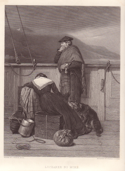
"The sailing of an immigrant vessel was a deeply emotional experience, for those leaving and for those who remained. The Highlanders were like children, uninhibited in their feelings and wildly demonstrative in their grief. Men and women wept without constraint. They flung themselves on the earth they were leaving, clinging to it so fiercely that sailors had to prise them free and carry them bodily to the boats. A correspondent of the Inverness Courier watched the departure of some Kildonan people from Helmsdale: 'Hands were wrung and wrung again, bumbers of whisky tossed wildly off amidst cheers and shouts; the women were forced almost fainting into the boats; and the crowd upon the shore burst into a long, loud cheer. Again and again that cheer was raised and responded to from the boat, while bonnets were thrown into the air, handkerchiefs were waved, and last words of adieu shouted to the receding shore, while, high above all, the wild notes of the pipes were heard ...'"25
Martell estimated that 40,000 came to Nova Scotia as immigrants. In his preface to Martell's work, Harvey observed that there is an absence of specific returns of immigrants. Martell wrote: "Unlike many of the Pre-Loyalists and all or nearly all the Loyalists, the immigrants after 1815 who came to Nova Scotia from the British Isles were not, with a few exceptions, transported at the expense of the Imperial or Provincial government, land companies, or interested individuals.26 They received no implements or utensils to start them off, no regular rations to carry them over the first hard year or more, and no land laid out free of charge."27 Many of the poor Scots who arrived were obliged to pay for their passage and to fend for themselves in the uncleared forests. Charles W. Dunn:
"Life for him [the settler] was something more than a ceaseless round of cutting, burning, ploughing, planting, sowing, and reaping; and for his wife, something more than a grim monotony of cooking, carding, spinning, weaving, knitting, sewing, and mending. Their long hours of toil and their few well-deserved moments of leisure were always the occasion for laughter and story and song and music."28
Next, James Hunter:"... the many people here [Sydney] whose roots are in the Highlands have had an exceptionally raw deal from history. For a single family to have laboured in the kelp industry, to have been evicted from a croft, to have made the ocean crossing in an immigrant ship, to have hacked a farm out of virgin forest, to have found it impossible to make a living on that farm, to have gone into coal-mining, to have endured that industry's grim casualty toll and to have seen, at the end of all of this, the mines shut down is, whatever way you look at it, to have endured an awful lot in the space of half a dozen generations."29
The system of granting land -- at least in Cape Breton up to 1820 -- "was a source of much dissatisfaction."30 With the arrival of James Kempt, in 1820, as the newly appointed Royal Governor of Nova Scotia, things were in for a change. Within four months of his arrival in Nova Scotia, Kempt made a tour of Cape Breton."One of his first acts was to issue a code of instructions to the Surveyor-General, to lay off lands in lots of 100 acres to single, and of 200 acres to married men, with permission to occupy them under tickets of location until they were prepared to pay for grants, with the proviso, that no absolute title should be given except to bona fide settlers who had actually made improvements."31
The problem -- of obtaining good title to their lands -- for the Scottish immigrants continued for most of the first half of the 19th century, though there were attempts to alleviate the problem."In 1841 ... Lieutenant-Governor Falkland informed the Colonial Office that he had dispensed with public auction in Cape Breton and allowed settlers to occupy crown lands on the payment of a fixed price of 2s.6d. an acre. This modification might have appeared advantageous to the lieutenant-governor, but Surveyor-General Crawley soon pointed out that the intended purchasers consisted of 1,500 poor souls from the Hebrides, who possessed neither the power nor the inclination to avail themselves of Falkland's kind offer. Indeed, the majority had at once settled themselves on one of the larger grants of the absentees. Admittedly, two or three of these immigrants made enquiries at the land office, but they had frankly admitted that their intention was not to purchase crown land but to ascertain where vacant land could be found so that they could settle on it without purchase or permission."32
[TOC]
Scottish Immigration To Cape Breton For a variety of reasons, Cape Breton was slow to make itself ready to accept new immigrants, of any kind.33 More generally, it might be stated that during the war years (1793-1815) no one risked voyages at sea unless made in the company of a British Man-of-War. There was a short respite period when in 1802, the Treaty of Amiens was signed; the period lasted but eighteen months. Enough time, however, to set immigrant ships in motion from Scotland to America. During August of 1802, the first boat load of Scottish immigrants, 299, arrived at Spanish Bay (Sydney).34 We should note that it was in 1803 that Selkirk35 landed immigrants from the Scottish highlands at Prince Edward Island.36 Many of those that were first landed in Prince Edward Island, left to join their cousins who had been, by then, reasonably well settled in the Pictou area. With the Napoleonic Wars under way again, few Scottish immigrant ships came to Nova Scotia, until 1817, that is two years after the war had ended.
I suspect that the authorities kept track of the immigrant Ships that came into Pictou more so than those that landed at Cape Breton:
"Nor did these people's troubles end with the Atlantic crossing. Because Cape Breton was the earliest landfall made by ships heading ultimately for St Lawrence and Quebec, aspiring immigrants could get here more economically than they could travel to any other part of North America. And because Cape Breton's coastline, rather like that of the Scottish Highlands, is replete with sheltered coves and inlets, it was possible for those less scrupulous skippers who were common in the timber trade to put their passengers ashore in remote and unregulated harbours in order to avoid the delays and complexities which would have been encountered at more formal ports of entry to North America. 'Several vessels arrive annually and land their passengers on the western shore of this island,' customs officers complained from Sydney, 'the masters neglecting to make any report of the number.'"37
In 1817 there arrived two ships at Sydney, the Hope and the William Tell, both from Barra with 382 people aboard.38 That is all I can tell about these two vessels. Passenger lists for the two do not exist as is the case for most all the Scottish immigrant ships, though there has been some attempt to reconstruct them. The greatest number of Scottish immigrant ships came in following 1820 and carried on in reasonably steady numbers through to the middle of the 19th century. It is no coincidence, I should think, that beginning in 1820, a new official position in regards Cape Breton became evident. As we have already pointed out, in October of that year, the newly appointed the Royal Governor of Nova Scotia, Sir James Kempt, within four months of his arrival in Nova Scotia, made a tour of Cape Breton. On the 9th he declared that Cape Breton, which had been an independent British colony since 1784, was to be re-annexed to Nova Scotia as one of its counties. This brought in its train changes in the justice system.39 This was important for any commercial development of the island, as people with capital need the protection of the law, especially a registry system in respect to real property.
Moorsom, who made his observations in 1827, estimated the population of Nova Scotia, including Cape Breton, at 143,000. He estimated that of this only 600 were Indian and 1,500 were black. A doubling, Moorsom concluded, of the 1817 population of 72,000. While the information we have is shaky in regards to which ships came in from Scotland with immigrants aboard, we have as a practical matter no information who these Scottish people were and where they went to build their little huts and start life anew. Though, we do know, that these Scottish settlers flooded in and were in a destitute condition for a period of time.
James Hunter:
"... the town's magistrates noted in 1828, upwards of 2,100 persons have come into this district [Cape Breton] from the western part of Scotland many of whom, on their landing, were quite destitute of food and also of the means of procuring it. Sydney was again thought to be at risk from smallpox. And great numbers of newly disembarked Highlanders had been reduced to begging from door to door."40
In 1830, the "Surveyor General Crawley informed the Provincial Secretary that Cape Breton was 'threatened with a dreadful inundation from Scotland amounting to 3,000 souls,' and suggested that lots should be laid out for them in advance, to which they might repair at once, 'instead of lying about our beaches to be consumed by want and sickness."41 The question becomes -- What were the reasons for coming to Nova Scotia. Professor Bumsted put his finger on one of the reason, a surprising reason, given Culloden."Ironically enough, in view of their earlier treatment by the British, Highlanders were extremely loyal to King and Country in the American colonies, and they were much persecuted during the war as Tories or Loyalists. Many recently-emigrated Highlanders ended up fighting against the Americans in Loyalist or British regiments, then being disbanded and receiving land in the provinces of British North America which remained within the Empire after the débâcle. Highlanders had always been more inclined than Lowlanders to emigrate to the wilderness colonies of Nova Scotia, the Island of St John, and Canada, and with peace they were joined by many of their fellow Highlanders who had initially sought a place in the rebellious American colonies to the south."42
Abraham Gesner, the discover of Kerosene, a native son of Nova Scotia, said this of the Scottish settler:"Perhaps there are no race of people better adapted to the climate of North America [Cape Breton] than that of the Highlands of Scotland. The habits, employments, and customs of the Highlander seem to fit him for the American forest, which he penetrates without feeling the gloom and melancholy experienced by those who have been brought up in towns and amidst the fertile fields of highly cultivated districts. Scotch immigrants are hardy, industrious, and cheerful, and experience has fully proved that no people meet the first difficulties of settling wild lands with greater patience and fortitude."43
Most all of these Highlanders eventually made homes for themselves, and things soon settled down into a comfortable rural routine in a number of areas in Cape Breton. This routine was nicely described by Charles W. Dunn:"As the spring moves grudgingly along there is always plenty of work for the men-folk to do. The farmer gets his equipment ready for planting. The fisherman overhauls his boat and engine, and mends his nets, or completes his lobster traps. Both fisherman and farmer inspect their fences and put in new posts and poles wherever they are needed. The cows calf; the mares foal; the sheep lamb; the hens are set on their eggs, and hatch out their chicks, and the household cat proudly summons her new kittens out from the barn.
[TOC]
Then the busy season begins. The fisherman leaves his house and takes up his residence at the shore, immersing himself in a tangle of rope, lines, crates, kegs, barrels, nets, traps, hooks, and buckets. In a short he is out to sea, setting the traps and nets, trying to guess where the fish will run this season. From then on through the summer he is never idle. Each kind of fish requires special gear and a special technique -- salmon, herring, mackerel, cod, lobster -- and all require incessant watchfulness and toil.
The farmer, at the same, is trying to foresee what nature is going to bring him in the way of weather. He begins to plough and harrow and sow and plant. Summer moves on. The seeds entrusted to the soil thrust out green blades. Finally the season brought home. The tempo of life slows down. The people are secure for another year. Whatever may befall, they will have plenty to eat. ....
In winter when it is impossible to get to a store the wise farmer or fisherman has a well-stocked house. Even in an isolated settlement at this time of the year it is not uncommon to find in a fisherman's house fresh eggs, milk, cream, and butter; half a carcass of beef hanging frozen in the out-house; a barrelful of home-killed pork, and cuts of home-cured ham and bacon; a hundred-pound box of dry-salt-cod, a barrel of salt herring; miscellaneous frozen fish recently caught, such as cod, skate, and ells; home-canned fruit; and a store of other necessities purchased in the autumn."44
Conclusion The adversities faced by the pioneers that came to Nova Scotia convinced a number, after a winter season or two, to go south into the lands of promise and plenty, the United States, with a climate not to be found in Nova Scotia. But the Scots -- well, they were use to the climate of Nova Scotia before they even set a foot on its soil. The hard times experienced by the Highlanders only served to enhanced the ingrained character of a Scottish person:
"All the perplexity and doggedness of the race was in him, its loneliness, tenderness and affection, its deceptive vitality, its quick flashes of violence, its dog-whistle sensitivity to sounds to which Anglo-Saxons are stone deaf, its incapacity to tell its heart to foreigners save in terms foreigners do not comprehend, its resigned indifference to whether they comprehend or not. It's not easy being Scotch, he told me once. To which I suppose another Scotchman might say, It wasn't meant to be."45
In Scott's Fair maid of Perth there is a scene in chapter viii where one of the characters introduces himself:"My name is the Devil's Dick of Hellgarth, well known in Annandale for a gentle Johnstone. I follow the stout Laird of Wamphray, who rides with his kinsman, the redoubted Lord of Johnstone, who is banded with the doughty earl of Douglas; and the Earl, and the Lord, and the laird, and I, the esquire, fly our hawks where we find our game, and ask no man whose ground we ride over."
It was these freedom loving persons, these people of the Scottish Highlands who came to Nova Scotia in considerable numbers during the first half of the 19th century. The succeeding generations mixed in to the existing populations that had earlier come to Nova Scotia: the French, the English and the German and thus was formed the unique strain of individuals that call themselves Nova Scotians.
-- End
_______________________________
Authorities
Ashton, T. S., An Economic History of England: The 18th Century (London: Methuen, 1955)
Brown, A History of the Island of Cape Breton (1869) (Belleville: Mika, 1979)
Bumsted, The People's Clearance: Highland Emigration to British North America: 1770-1815, (University of Manitoba Press, 1982)
Burroughs, "The Administration of Crown Lands in Nova Scotia, 1827-1848," NSHS, #35
Collier, The Crofting Problem, (Cambridge University Press, 1953)
Dunn, Highland Settler: A Portrait of the Scottish Gael in Nova Scotia, (University of Toronto, 1953)
Ells, Calendar of Official Correspondence and Legislative Papers Nova Scotia, 1802-1815; compiled by, Pub. #3 (Halifax: PANS, 1936)
Harvey, "Scottish Immigration to Cape Breton," Dalhousie Review, Vol. 21 (1941)
Hill, The Scots to Canada (London: Gentry Books, 1972)
Hunter, A Dance Called America (1994) (Mainstream Publishing, 1998)
Johnson, The Birth of the Modern, (New York: HarperCollins, 1991)
Macdonald, The Last Siege of Louisbourg (London: Printed for the Author by Cassell & Co., 1907)
Martell, Immigration To And Emigration From Nova Scotia: 1815-1838, (Halifax: PANS, Publication No. #6, 1941)
Prebble, The Highland Clearances, (1963) (Penguin)
Savary's supplement, History of the County of Annapolis (1913), (Belleville: Mika, 1973)
Trevelyan, G. M., England Under Queen Anne: 1702-1714 (1930, 1932, 1934), (London: Longmans, Green; 1948)
--, English Social History (Toronto: Longmans, Green; 1st Can ed., 1946)
Navy Records Society, The Royal Navy and North America (London: Vol. 118, 1973)
Woodward, The Age of Reform: 1815-1870 (1938)(Oxford: Clarendon Press, 2nd ed., 1962)
_______________________________
---------------
HISTORY OF NOVA SCOTIA=-
This jump off page will lead one into things historical.- NOVA SCOTIA
"The Micmac of Megumaagee"
"Unfortunately for the Indians, their enemies have
been their only historians; the records of their cruelties remain, but the
wrongs which provoked them are either untold, or are ignored and
forgotten." (Hannay,
p. 51.)
>>>>>>>>>>>>>>>>>>>>>>>>>>>>>>>>
GO TO TABLE OF
CONTENTS.
>>>>>>>>>>
A Selection of Micmac Words
<<<<<<<<<<
|
|||
Let us look in on a scene as described by Elizabeth Frame:
"Here some of the women were busy sewing new and
repairing old birch-bark canoes. In this primitive ship-yard neither broad-axe
nor caulking-mallet was required. The framework was made of split ash, shaped
with a knife and moulded by hand; this was covered with sheets of white
birch-bark, sewed round the wood-work with the tough root-lets of trees. The
wigwams were formed of poles stuck into the ground and secured at the top by a
withe.1 This
circular inclosure was covered with birch-bark; a blanket or skin covered the
aperture which served for a door; and the centre was occupied by the fire, the
struggling smoke of which found its way out at the top. Round the fire, boughs
were laid, which served the family for seats. Dogs snored around the camps, and
papooses lay sleeping in the cradles strapped to their mothers' backs, their
brown faces upturned to the sun. One mother sat apart, nursing a dying babe.
She had prepared a tiny carrying belt, a little pail, and a paddle, to aid her
child in the spirit land. Beside the spring some women were preparing the feast
for the congregated warriors. Over the fire were suspended cauldrons containing
a savory stew of porcupine, caribou, and duck. Salmon were roasting before the
fires, the fish being inserted, wedge fashion, into a split piece of ash some
two feet in length, crossed by other splits, its end planted firmly into the
earth at a convenient distance from the fire."2
Who were these people? They were northern Indians who
have long occupied the forests of the northeastern parts of the North American
continent.
"They were a typical
migratory people who lived in the woods during the winter months, hunting
moose, caribou and porcupine. In the spring they moved down to the seashore
where they gathered shellfish, fished at the mouths of rivers and hunted the
coastal seals. Like most Algonquin
tribes, they lived in conical wigwams covered with birch bark while making
canoes and household utensils from the same material. They also made cooking
pots from clay and large wooden troughs in which they boiled their food by
dropping stones, heated by the fire, into the water. Their weapons were stone3 tomahawks,
stone knives, bows and arrows and spears with two edged blades of moose bone or
other animals bones."4
George MacLaren was writing of the original
natives of a land which I refer to as Old Acadia; but which the natives at the
time referred to as Megumaagee.
They were stone age people, who, in their original state, were only but briefly
sighted when the earliest of the European explorers came to the shores of an
area which we now call the Canadian Maritime Provinces. What was had was but a
glimpse of a people who were to be divested by the glimpsers. The fact of the
matter is that within a generation, the Micmac were hurtled into a new age. So,
therefore, what was to be recorded (a new age activity) and handed down to us:
are but indistinct images, reflections and shadows of a people whose culture
and traditions we shall never know in their true form, being, as they were,
obliterated by European influences. The Micmac, their beliefs, their
traditions, were all to change because of the processes of acculturation and
miscegenation.5
[TOP][TOC]
The Origins of the Micmac
The ancestors of the Micmac -- like the ancestors of all of us who currently occupy the Americas -- came to occupy their traditional home lands through immigration. As to the time and manner of the immigration: it is, but speculation. The best thinking, it seems, is that the Palaeo Indians came into the area we now know as Nova Scotia some 11,000 years ago. They were but a branch of the original immigrants to the Americas: all came over from Asia via Siberia and slowly, in their nomadic fashion, spread south and east. Actually, it is thought,6 that these original people either died off or further immigrated. The Micmac people, likely lived further south before they came into the lands of our larger story, Acadia -- the ocean shores, from Gaspé to Cape Sable.7 There had been, as may be determined from the writings of the early explorers, a rather dramatic shift of the north American tribes, certainly for those in the northeast quarter of North America. This, likely, due to the ferociousness of the Iroquois. The ancestral home of the Iroquois was in an area now identified as upstate New York, the Mohawk River and the Finger Lakes. The influence of the Iroquois spread, directly and indirectly, across great distances. The Micmac, though they could make as great a show as any nation, were of a milder and retiring spirit; they were, as a consequence, under great pressure from their fiercer southern neighbors. It would appear at the time Acadia was first established, circa 1600, the Micmac were being pushed to the northeastern extremities of the continent.
[TOP]
[TOC]
Population Levels
Paul Mascarene reported,8 in 1720, that "the Indians are but a handful in this country."9 The estimates of the Micmac population varied widely. 10 A census of 1687-8 discloses that there were then 925 Indians in territories that now form part of Nova Scotia and New Brunswick.11 One count in 1721 was 289 and another, in 1722, 838. 12 In 1739, the Indian population was estimated: 200 braves in Acadia, 80 in Cape Breton, 195 at Miramichi and 60 at Restigouche.13 (Miramichi and Restigouche are to be located in the present day province of New Brunswick.) Further, in 1739, a memorandum to Isaac Louis de Forant, one made in order to acquaint him with his new post as the new governor of Ile Royal, set forth a number of 1,200. This number covered the principal encampments of the Micmac which we see listed in the report: Miragouëche, Port-Royal, La Heve, Cape Sable, Miramichi, and Restigouche.14 Thus, as we can see these numbers vary, and do not, in any event, include the Malecites of the St. John. I should say, that the first reliable number that we have is that which was struck as a result of the census of 1871: the Micmac of Nova Scotia at that time numbered 1,666.15
The above accounts were those made only after the arrival of the Europeans. As to the Micmac population before then? Well, James Hannay, one of our most reliable historians of the era, was of the view that the total population never likely exceeded 3,000. This conclusion is not hard to accept if one remembers that the original natives, as found, were "hunter gatherers." As Hannay points out: "An uncultivated country can only support a limited population. The hunter must draw his sustenance from a very wide range of territory ..."16
[TOP]
[TOC]
Spiritual Beliefs
"Their primitive religion is obscure. They
recognized a Great Spirit, or even several Great Spirits, whom they called
Manitous - in Micmac Mento or Minto (pronounced Mendoo) [see Manitou]
- and they had no other personal divinities. Interiorly they feared Manitou and
revered and adored him, while exteriorly they offered him sacrifices and made
him part of their sorcery, seeking to render him favourable, or rather to
prevent his harming or hindering them in their various enterprises. From the
time of their forefathers, they said, Manitou had kept plaguing them. They did
not look upon him as all-powerful or benevolent, nor did they speak of him as
their creator. There is no evidence that they believed in any sort of
creation."17
The Micmac, in a Spinozistic
sense, certainly did believe in creation; and, did believe and recognized a
higher power as having control of their destiny, a power that was entitled to
reverence. These beliefs, indeed, was one of the distinguishing features of the
North American Indian. Their general mental and moral attitude was totally
shaped by their belief in nature, as God. They had no need, nor did they
organize themselves into religious groups with rules and rulers, however, the
European missionaries were only too keen to introduce the notion of organized
religion: all the better, for the purposes of control. Lescarbot,
based on his personal observations, quotes, with approval, his fellow
countryman and explorer, Jacques Cartier, who had been in the territory 65
years earlier, between 1535 and 1541:
"They believe also
that when they die they go up into the stars, and afterwards they go into fair
green fields, full of fair trees, flowers, and rare fruits. After they had made
us to understand these things, we showed them their error, and that their
Cudouagni is an evil spirit that deceiveth them, and that there is but one God,
which is in Heaven, who doth give unto us all, and is Creator of all things,
and that in him we must only believe, and that they must be baptized, or go
into hell. And many other things of our faith were showed them, which they
easily believed, and called their Cudouagni, Agoiuda."18 (Lescarbot.)
"A dog was regarded
as the most valuable sacrifice, and if, in crossing a lake, their canoe was in
danger of being overwhelmed by the winds and waves a dog was thrown overboard,
with its fore paws tied together, to satisfy the hunger of the angry Manitou.
They were continually on the watch for omens, and easily deterred from any
enterprise by a sign which they regarded as unfavourable. A hunter would turn
back from the most promising expedition at the cry of some wild animal which he
thought was an omen of failure in the chase."19
The spirits in which the Micmac belief were not all "vague and
indefinite"; indeed, some were distinct and identifiable. The one that
readily comes to mind is Glooskap. Glooskap was the chief spirit of the Micmac:
he had a myriad of lesser spirits that attended upon him: he created man from
the heart of the ash tree. The names of all the birds and animals were long ago
named by Glooskap. Glooskap, it was said, would ride on the backs of the whales
and the loons were his willing messengers.
"While he roamed the province incessantly, encamping
in many different spots, his chief abiding place was the crest of Blomidon.
Before his time the beavers, who were then huge, powerful beasts, had built a
great dam across the strait from Blomidon to the Cumberland shore, thus making
Minas Basin an immense pond or inland sea. One day by speaking a word or by
waving his wand, Glooscap broke the beaver dam and let the fierce Fundy tides
rush in, as they have ever since continued to do. Towards a beaver who was in
hiding near, and whom the demigod wanted to frighten, he once tossed a few
handfuls of earth. These lodging a little to the eastward of Parrsborough
became Five Islands."20
Champlain,
as most of these religious Frenchman were, was perplexed because he could not
observe any outward manifestations of the Indian worship of nature:
"I demanded of him what ceremony they used in
praying to their God: he told me that they used no other ceremony but that
everyone did pray in his heart as he would. This is the cause why, I believe,
there is no law among them, neither do they know what it is to worship or pray
to God, and live the most part as brute beasts; and I believe that in short
time they might be brought to be good Christians, if one would inhabit their
land, which most of them do desire. They have among them some savages whom they
call Pilotoua, who speak visibly to the devil, and the telleth them what they
must do, as well for wars as for other things; and if he should command them to
go and put any enterprise in execution, or to kill a Frenchman or any other of
their nation, they will immediately obey to his command. They believe also that
all their dreams are true; and, indeed, there be many of them which do say that
they have seen and dreamed things that do happen or shall come to pass; but to
speak thereof in truth they be visions of the Devil, who doth deceive and
seduce them."21
The work of the missionary in converting the natives, was,
apparently, not too difficult, as Lescarbot observed:
"These people (as
one may say) have nothing of all that, for it is not to be called covered, to
be always wandering and lodged under four stakes, and to have a skin upon their
back; neither do I call eating and living, to eat all at once and starve the
next day, not providing for the next day.22 Whosoever
then shall give bread and clothing to these people, the same shall be, as it
were, their God: they will believe all that he shall say to them ... These
people then enjoying the fruits of the use of trades and tillage of the ground
will believe all that shall be told them, in auditum auris, at the first voice
that shall sound in their ears; ... [an example of the chief of the St. John
Indians] he eateth, lifteth up his eyes to heaven and maketh the sign of the
Cross, because he hath seen us do so: yea, at our prayers he did kneel down as
we did. And because he hath seen a great Cross planted near to our fort, he
hath made the like at his house, and in all his cabins; and carrieth one at his
breast ...."23
(Lescarbot.)
In any event, it seems that the North American natives
were predisposed to adapting the European religion. There was a myth handed
down from the generations past that all powerful white Gods would come from the
east to teach and show them the way to a glorious future. The Irish novelist,
Eliot Warburton in his preface to his brother's, George
Warburton's work, Hochelaga (1846) made reference to this feeling that ran
among the natives:
"Strange to say, this prophetic feeling [the east
overcomes the west] was responded to by the inhabitants of the unknown world:
among the wild and stern Mic-Macs of the North, and the refined and gentle
Yncas of the South, a presentiment of their coming fate was felt. They believed
that a powerful race of men were to come 'from the rising sun,' to conquer and
possess their lands."
"They [the Micmacs]
were distinguished for their honesty. They were still more distinguished for
their chastity. There is no instance on record of any insult being offered to a
female captive by any of the Eastern Indians, however cruelly she might
otherwise have been treated."24
The rulers (to the extent there were any) were male.25 The
successful hunters, the providers of food for the family, the extended family,
the tribe, were always to be given general preference and respect. The best of
them was the chief. The chiefs were semi-hereditary.26 Though the
sons of a chief always had the edge, any brave warrior/hunter could become a
chief; continual success in the hunt or when fighting enemies would bring a
young man to the top of his tribe.[TOP]
[TOC]
The Medicine Man
The Medicine man, not one who was necessarily a good hunter or warrior, was also much respected and regularly consulted before the tribe struck out on any sort of an adventure. He was a special man who had proved himself as being able to call on the spirits, predict the future and thereby able to steer the tribe in the right direction.
"If anyone be sick, he [well decked out with maracas
or rattles, and feathers] is sent for; he maketh invocations on his devil; he
bloweth upon the part grieved; he maketh incisions, sucketh the bad blood from
it: if it be a wound, he healeth it by the same means, applying a round slice
of the beaver's stones. Finally some present is made unto him, either of
venison or skins. If it be question to have news of things absent, having first
questioned with his spirit, he rendereth his oracles ...."27 (Lescarbot.)
"So implicit was the belief in the medicine-man that when he
pronounced a disease or a wound fatal, the patient ceased eating, and was given
nothing more; he put on a fine robe and chanted his death-song.28 To hasten
his end, the onlookers would throw cold water over him, or sometimes bury him
half alive."29
(Diereville.) First thing that was to be done upon the death of an individual is for the family and the tribe to have a feast, one that continued for a couple of days during which numerous orations were pronounced.
"On the third day a feast was held as a recognition
of the great satisfaction which the deceased was supposed to feel at rejoining
his ancestors. After this the women made a garment, or winding sheet, of birch
bark, in which he was wrapped and put away on a sort of scaffold for twelve
months to dry. At the end of that time the body was buried in a grave, in which
the relatives at the same time threw bows, arrows, snow-shoes, darts, robes,
axes, pots, moccasins and skins."30
Lescarbot gives an accounting of the funeral ceremonies
of a respected member of the tribe, one, Panoniac. Panoniac had traveled south
down the coast, likely to the Cape Cod area, there to trade with their old
enemy, the Armouchiquois. Panoniac, unfortunately, got the bad end of a bargain
and was killed or badly wounded such that he eventually died. Panoniac, or his
body was brought back up the coast. Lescarbot made the following observations:
"After our savages
had wept for Panoniac, they went to the place where his cabin was whilst he did
live, and there they did burn all that he had left, his bows, arrows, quivers,
his beavers' skins, his tobacco (without which they cannot live), his dogs31, and other
his small movables, to the end that no body should quarrel for his
succession."32
(Lescarbot.)
The natives apparently did bury Panoniac, in the spring, just before
getting a war party together so to go to revenge his death. They dug Panoniac
up and transported his remains to "a desolate island, towards Cap de
Sable, some five-and-twenty or thirty leagues distant from Port Royal. Those
isles which do serve them for churchyards are secret amongst them, for fear some
enemy should seek to torment the bones of their dead."33 Further,
"after they have brought the dead to his rest, every
one maketh him a present of the best thing he hath. Some do cover him with many
skins of beavers, of otters, and other beasts; others present him with bows,
arrows, quivers, knives, matachias, and other things."34 (Lescarbot.)
Into the Grave they put
a living Dog,
Hatchet and Corn, a blanket and a Pipe,
Tobacco, Powder, Lead and Pot, Canoe
And musket for they think that he who dies
Will make a Journey of great length
And will have need of all this Gear
For clothing and for nourishment.35 (Diereville.)
The Micmacs, though a wary lot, were
described by the first Jesuit missionaries as "mild and peaceful in
temperament."36 They,
certainly, were often men of few words. Lescarbot
recounts he saw many times how a total stranger would arrive at an encampment
of Micmacs set up outside the walls of the habitation at Port Royal. The
stranger would somehow know which hut to enter, the hut of the chief, Membertou.
The stranger would immediately sit down, take out his pouch of tobacco, fill
and light his pipe, take a number of hauls on the stem and then "did give
the tobacco-pipe to him that seemed to be the worthiest person, and after
consequently to the others. Then some half an hour after they did begin to
speak."Hatchet and Corn, a blanket and a Pipe,
Tobacco, Powder, Lead and Pot, Canoe
And musket for they think that he who dies
Will make a Journey of great length
And will have need of all this Gear
For clothing and for nourishment.35 (Diereville.)
The Micmac, as it seems with all the North American natives were very sociable. They would interact freely amongst themselves and were very hospitable even to strangers who might come among them. They would readily share their food and their tobacco and invite them, for example, into their sweat hut.37
As for a sweat hut, or pit: Lescarbot describes one38: they "dig in the ground, and make a pit which they cover with wood and big flat stones over it; then they put fire to it by a hole, and, the wood being burned, they make a raft with poles, which they cover with all the skins and other coverings which they have, so as no air entereth therein; they cast water on the said stones, which are fallen in the pit, and do cover them; then put themselves under the same raft" and there they sit in spiritual union, in song and in motion.
Diereville also gave a description of the sweat hut:
"They dig a hole as
long as themselves, & line it on both sides with stones which have been
heated at the fire until they are almost red; after that they place a layer of
Fir branches at the bottom, & lie down at full length upon them. They are
then covered with other branches, which, because of their bituminous nature,
give forth a dense vapour as they grow warm; it is not long before they are
sweating to the very bone, & for as long a time as they desire. What
surprised me most, was to know that these sudorific Ovens are always
constructed on the edge of a Lake or River, & that the Indians emerge all
dripping, only to plunge instantly into the water."39
(Diereville.)
As for tobacco: it was to be for the Micmac
always ready at hand, he was always in need of it. Tobacco was therfore an
easily traded item; it was a unversal medium of exchange. (The other easily
traded commodities were powder and shot, and, of course, liquor.)40 The natives
kept tobacco on their person at all times; they "have certain small bags
of leather hanging around about their necks or at their girdles."41 "They
smoke with excessive eagerness ... men, women, girls and boys, all find their
keenest pleasure in this way."42
And dancing:
"These ridiculous
Dancers follow one another around in a circle, clinging together & moving
forward very slowly, by leaping with joined feet, executing contortions &
making faces, each more hideous than the last. A certain vocal note like this:
Houen, houen, houen, if one can so express it, marks the cadence, & they
pause from time to time to give utterance to the terrifying yells with which
the dances always end. The instrument which provides the accompaniment is
perfectly suited to all this; it is a little stick about a foot long, which an
Indian who is not dancing, strikes against a tree, or some other object,
according to the place in which they happen to be, singing through his nose at
the same time."43
(Diereville.)
"They put some
number of beans, coloured and painted of the one side in a platter; and, having
stretched out a skin on the ground, they play thereupon, striking with the dish
upon this skin, and by that means the beans do skip in the air, and do not all
fall on that part that they be coloured; and in that consisteth the chance and
hazard - and according to their chance they have a certain number of quills
made of rushes, which they distribute to him that winneth for to keep the
reckoning."44 (Lescarbot.)
Micmac society was paternal, like that of the European society, versus, Iroquoian
social organization which was maternal.45 In Diereville's Relation, we see where an
analogy was made of the beaver to the family structure of the Micmac. The aged
beaver watches over all the rest. Once a beaver establishes his family in a
spot the family will not allow any other beavers to come into the territory and
will go to war to defend their stake and deal with "vagabond
beavers."46The men, apparently, had no care for anything but hunting and going off to war: the women, "neither being forced or tormented" did all the work.47 Women were not allowed to sit in on any of the councils or attend any of the feasts.48 Where a kill had been made on a hunt the animal would be left where it fell; the women would "go flay it and to fetch it, yea, were it three leagues off ..." The woman made all the clothes for the family, quietly chewing and sewing.49 When, in the spring, it was time to obtain a store of bark for their houses and the canoes; again, it was the women who did all the work. Whether out of fear or love, the women were not heard to complain.50
Woman, for example, were an integrate part of an Indian travel party as Samuel Hearne's traveling companion, Matonabbee, points out: "Women were made for labour," said Matonabbee, "one of them can carry, or haul as much as two men can do ... there is no such thing as traveling any considerable distance, or for any length of time, in this country without their assistance." He himself traveled with from five to eight wives, "most of whom would for size have made good grenadiers." Hearne appreciated their usefulness, but was repeatedly appalled by the way in which they were treated.51
[TOP]
[TOC]
Marriage
"If he possessed a canoe, gun and ammunition, spear,
hatchet, a moonodah, or pouch, looking-glass, paint, pipe, tobacco, and dice
bowl, he was looked upon as a man of wealth, and very eligible for a husband. A
squaw who could make pouches, birch dishes, snow-shoes, moccasins, string
wampum beads, and boil the kettle, was considered a highly accomplished lady.
The courtship was extremely simple and short. The lover, after advising with
his relations as to the girl he should choose, went to the wigwam where she
was, and if he liked her looks, tossed a chip or stick into her lap, which she
would take, and, after looking at it with well-feigned wonder, if she liked her
lover's looks, would toss it back to him with a sweet smile. That was the
signal that was accepted. But if she desired to reject him, she threw the chip
aside with a frown."52
From Lescarbot we determine that a father
would not give his daughter to a man unless he had some means by his industry
to nourish and maintain both the daughter and his future grandchildren.
Diereville disclosed how the young male Indian would have to seek out the
father of the maiden and prove to him that he was going to be a good hunter.
Also, Diereville goes into how the couple themselves might know what it is that
each would find acceptable in the other (by accepting gifts53). Once the
maiden's family was won over, then there was not much ceremony, the girl would
follow her new husband into the woods so that they might go on a hunting trip;
they would come back with the game they caught and a marriage banquet would
then take place.
Like so many of the native customs and traditions, those surrounding
marriage changed when the Europeans arrived. Christian notions were imposed
upon the willing Micmac. The French priests wanted to see a Christian marriage
ceremony; and, so it was to become that the family would get the young couple
to go over to the church. The conversation between families in respect to a
young couple in the tribe, who appear to be eyeing one another, usually led to
the question, "when are they to stand up in church?"
"I have seen some
who have come from a great distance in order to receive this Sacrament from the
Curé of Port Royal, & I have even seen those who had been married in the
Indian fashion renew their vows before our Altars. Although it is one of the
most sacred rites, I could not help laughing. The Curé, who did not understand
the Indian language, & was no better able to speak it, had as Interpreter
one of his Parishioners who understood & spoke it very well; he would say
to him, in French, all the beautiful things he could about the excellence &
duties of matrimony; the Interpreter repeated the same in the Indian tongue to
the prospective Husband & Wife, who, by their demonstrations, appeared to
be charmed by them; then, repeating after the Curé, he asked whether they would
follow from point to point all the instructions he had given them; they, in
their own language, promised to do so, which was interpreted into good French
& testified to the Curé, who proceeded in this fashion until the couple had
been united."54 (Diereville.)
Before the times when the French
missionaries exercised their influence, it was not considered unusual for a man
to have more than one wife. "Sometimes our (Lescarbot) savages having many
wives will give one of them to their friend ..." Men were generally very
particular about the behaviour of their wife or wives, and "if the wife
should be found to be faulty, she will be put away or in danger to be killed by
her husband ..." If a woman should lose her husband through death, she
does not marry again, but go about declaring her widowhood by daubing their
face with coal beaten to powder and with grease and applied thickly. Indeed, as
Lescarbot points out, they may dramatically change their diet - not eat meat -
until the death of her husband has been revenged.55
[TOP][TOC]
Children
"When the wife is in labour & believes that
delivery is at hand, she leaves the Wigwam & goes some distance into the
Forest with a Squaw to assist her, and the business is soon over. The Mother
gives the Woman, who has delivered the Child, the knife with which the cord has
been cut, and that is her only recompense.
To fortify his skin against
The rigour of the bitter cold,
Which in such climates must be borne,
They wash him in the stream; no less
In winter's hard and cruel days
Than in the fairest Summer time.
The rigour of the bitter cold,
Which in such climates must be borne,
They wash him in the stream; no less
In winter's hard and cruel days
Than in the fairest Summer time.
The first nourishment he takes is Fish oil or the melted
fat of some animal. The Papoose is forced to swallow this, after which he gets
only his mother's milk until he is strong enough to live as the others do. He
is swathed in the skins of Foxes, Swans, & Wild Geese, & a bundle of
moss is placed on his hinder parts to keep him from spoiling such fine
swaddling clothes."56
The children would be slowly introduced to solid food by the mother,
and did so, as she ate her own food; she did the chewing until the little one
could handle it on his or her own. We see too from Lescarbot57 how a baby
board58 was
devised for the infants which "they carry on their backs, their legs
hanging down: then being returned into their cabins, they set them in this
manner up straight against stone or something else. And as in these are parts
[France] one gives small feathers and gilt things to little children, so they
hang a quantity of beads and small square toys, diversely coloured, in the
upper part of the said board or plank ..."
Apparently, the English soldiers when they captured a group
of Indians, as occurred in the southern frontier of Acadia, the present day
State of Maine, during the late 1600s, they would often bring the small Indian
children back home to Boston with them, and, in turn, send them over to England
as curiosities for their respective English families to admire.59[TOP]
[TOC]
Gathers, Fishers and Hunters
Unlike the tribes to the south, in the "northern area, especially among the Micmac, agriculture was absent."60 The Micmac, of course, would gather roots and herbs in order to supplement their sea food diet in the summer. In the winter the Micmac ate meat.61
As we have seen62, the Micmac, like all northern people in their primitive state, were a migratory people. They lived in the woods during the winter months, hunting moose, caribou and porcupine. In the spring they moved down to the seashore where they gathered shellfish and fished at the mouths of the rivers. They would take any fish they could get on a line or a spear and combed the shores at low tide and would place in their gathering baskets all manner of shelled fish, and, in season, the eggs.63
A few words on the Micmacs "nomadic self-sufficiency: In the fall of the year they broke their seashore camp and headed to their favourite winter camp, inland; up the rivers and along the lakes.64 The Indian hunting season usually extended from January to March. Sometimes, during a mild winter the hunting season did not come at all. The hunting technique for the northern Indian was dependent on their ingenuity and their understanding that an animal was normally at a distinct disadvantage during the winter. The Micmac hunting party would travel quickly with their snowshoes over the top of the frozen snow in order to run down the larger animals who laboured in the deep snow.65
The Beaver, too, though they might be trapped in the summer, were easier and less expensive to capture in the winter:
"The surest way is
to take them in traps; moreover, the bait put into these is nothing more than a
strip of Aspen bark, which they like above all other things, & it does not
cost so much as the powder & shot used in shooting them. Here is another
way in which they are caught; when winter hardens the surface of the water
where their huts are built, & they believe themselves well protected from
attack by the Hunters, the latter go out on the ice to break down the huts with
blows of their axes, & the Beavers are forced to abandon them, & escape
to the borders of the Lake, where they conceal themselves between the ice &
the bank, on which they lie upon their bellies; but in vane do they seek immunity
from death in this way; the Hunters set their Dogs to search all around the
Lake, & they have such good noses that they never fail to smell them, &
indicate the place by stopping; then the ice is shattered with great strokes of
the axe. It is rather surprising that the Beavers do not flee from the noise
thus made as they would under other circumstances. When the holes are cut, the
animals are uncovered, caught by their tails, dragged out, and their heads
broken with blows from an axe."66
(Diereville.)
The moment of the kill, after sometimes a
long chase, was a spiritual moment for an Indian hunting party. The kill meant
that the spirit of the animal was thus released, maybe, in part, to settle
itself in the brave hunters. Immediately the eyes of the animal, bird, or fish
were dug out and cast away, being of the belief that the creature as a class
saw through these eyes (dead or alive) and the hunter, on another hunt, would
have great difficulty to sneak up on the hunted animal. Also, for the same
reasons, a bone of an killed animal would not be given to a dog lest the
hunters might be prevented, in a future hunt, from killing another. The hunter
who actually brought the animal down, by silent and mutual understanding, was
relieved of any further onerous duties. "The one who kills an Animal,
satisfied with his skill and the honour which redounds to him, abandons it to
his Companions, who, in generous requital, always give him the best part when they
are dividing it among themselves."67
As for the cooking of the meat:
"The Indians cooked
their meat by broiling it on live coals, or roasting it on a sort of spit in
front of the fire. But soup was their favourite delicacy; they boiled it in a
capacious wooden cauldron made out of the butt of a large tree and hollowed out
by fire. As such a vessel was not easily made, they frequently regulated their
camping ground, in some measure, by the conveniences for establishing such a
soup-kettle. The soup was boiled by dropping red hot stones into the cauldron,
which, when cooled, were immediately replaced by others hot from the fire,
until the meat was cooked."68
One should not get the impression that the native Indians
feasted with any amount of regularity. A feast might be had if the tribe was
sufficiently moved to make preparations, at times when feasting was in order
such as when the braves were working themselves up to go off on a war party or
if the memory of recently departed member needed to be celebrated, a funeral;
and only ever if the hunters had just returned with a suitable catch. The
Indian feast usually consisted of "fish, flesh, or Indian corn and beans
boiled together." Further, women and children were excluded, though
allowed to take what was left over.
More often than not, though, normally, the Micmac in their natural state
suffered from great privations.
"Yet, although
certain seasons they luxuriated in abundance of food, at times they were
subject to the greatest privations and on the verge of starvation. Then, no
sort of food came amiss to them; reptiles, dogs, and animals of all sorts, were
eagerly sought after and ... devoured; roots of various kinds were in great
demand ..."69
"... they wash not
themselves at meals, unless they be monstrously foul; and, not having any use
of linen, when their hands be greasy they are constrained to wipe them on their
hairs or upon their dogs' hairs. They make no curiosity of belching being at
meals ... Not having the art of joiner's work, they dine upon the broad table
of the world, spreading a skin where they eat their meat, and sit on the
ground."70 (Lescarbot.)
I quote a contemporary observer who came to Port Royal in 1606, the 36
year old lawyer, Marc L'Escarbot:
"... they cover them with a skin tied to a latch or
girdle of leather, which, passing between their buttocks, joineth the other end
of the said latch behind. And for the rest of their garments they have a cloak
on their backs, made with many skins, whether they be of otters or of beavers,
and one only skin, whether it be of elan, or stag's skin, bear, or luserne,
which cloak is tied upward with a leather riband, and they thrust commonly one
arm out, but being in their cabins they put it off, unless it be cold."
"... in winter they
make good beaver sleeves, tied behind, which keep them very warm. ...
Our savages in the winter, going to sea or a-hunting, do use great and high stockings, like to our boot-hosen, which they tie to their girdles, and at the sides outward there is a great number of points without tags. I do not see that they of Brazil or Florida do use of them, but, seeing they have leather, they may as well make of them, if they have need as the others. Besides these long stockings, our savages do use shoes, which they call mekezin, which they fashion very properly, but they cannot endure long, specially when they go into watery places, because they be not curried or hardened, but only made after the manner of buff, which is the hide of an elan. ...
As for head-attire, none of the savages have any, unless it be that some of the hither lands truck his skins with Frenchmen for hats and caps; but rather both men and women wear their hairs flittering over their shoulders, neither bound nor ties except that the men do truss them upon the crown of the head ... with a leather lace, which they let hang down behind. ...
... when they go to the wars, they have about their heads as it were a crown made with long hairs of an elan, or stag, [leather] painted in red, pasted or otherwise fastened to a fillet of leather of three fingers breath ...
... our Souriquois ... carry a knife before their breasts, which they do not for ornaments but for want of pocket, and because it is an implement which at all times is necessary unto them."71
During Diereville's
time at Acadia, c. 1700, the Micmac were observed wearing72,
particularly during the winter, the skins of animals, this, in addition to a
blanket which they might have secured from the white man in a trade. No matter
the season, there was little difference in the dress of the man or the woman;
the garments on the women extended to the lower part of their legs. In the
summer they wore but a shirt and a belted loin piece (cloth or leather).
Stockings or chaps would be fashion out of leather or cloth by the Indians. Two
pieces would be sewed up and "there are always two flaps, Diereville
observes, which extend four fingers beyond the seam. It would appear too that
our Micmacs had the traditional laced up moccasin made out of either seal skin
or other skins which they had worn for a season. The leather parts of their
dress were often embellished with dyes and porcupine quills coloured red and white.73 Another
decoration was, as the Indians called it, matachias. It was braided cord by
which both men and women would bind up their hair. The matachias as Diereville
observed had small beads acquired from the white-man in trade; it can only be
imagined that these beads took the place of shells and quills used in earlier
times. As for cosmetics: "they use so much animal fat & Fish oil
especially on their faces, that they are almost invariably dripping with it,
& this is their usual perfume." Tattooing, incidently, was not known
among the Micmac, but they would, as Lescarbot points out74, on
occasion, put burning coals on their skin as a sign of courage which would make
lasting scars, of no particular design.
In the spring of the year it was a practical guarantee that the natives
would find white traders at the mouths of certain of the rivers. Down these
rivers would come the natives in their canoes filled with pelts obtained from
their winter catch. Polished as they were with a chafing motion and natural
skin oils throughout the course of a winter's use, the winter fur-clothing of
the natives was more highly valued by the trader then the raw pelts on the
bottoms of their canoes: the garment skins of these Indian paddlers were often
bought right off their backs. Thus, it was usual, in the spring, to see the
natives decked out in brand new cloth clothing, only to happy to get rid of
their heavy skins for shot, muskets, powder, pots, knives, hatchets, and alike.[TOP]
[TOC]
Tools
Our contemporary observer, Lescarbot, in chapter XVII of his history, deals with the tools and weapons of the Micmac. As he explains, the bows and arrows were "strong without fineness." Eagle feathers were used for the arrows. Originally, bone was used for the heads of the arrows; but, and quickly, upon the arrival of the white man, the natives were converted to using iron. Their maces, or clubs, were made out of hard wood. They used animal gut for bow strings and for tying the strips of leather to the frames of their "rackets" used to go hunting over the snow. Their canoes were made of bark. "When they remove, they put all that they have into them, wives, children, dogs, kettles, hatches, matachias [beadwork], bows, arrows, quivers, skins, and the coverings of their houses ... they are four foot broad ... sharp towards the ends, and the nose is made rising, for to pass commodiously upon the waves. ... And to the end they leak not, they cover the seams (which join the said barks together, which they make of roots) with the gum of fir trees."
[TOP]
[TOC]
Travel
The Micmac, like all Algonkin, were migratory and had developed the art of traveling, whether it was summer or winter, to a fine degree. For winter travel they used toboggans and snowshoes; for summer travel, the graceful bark canoe.
We have had passed down to us, a 1774 description on the making of a Micmac canoe:
"Their canoes are very ingeniously made mostly of
the bark of the birch tree, without nails, pins, leather or hemp; instead of
which they sew them up with root of trees, dyed different colours, and line
them with ashwood slit thin like the girth wood used for milk pails, etc. in
England. They are sharp at each end, about two feet wide in the middle, and
will carry four or five men; with the use of a paddle they make their way very
expeditiously on the water. We crossed the Annapolis River twice with an Indian
in one of these canoes."75
Bark from the tree, the principal building material of
the Indians, needed for such projects as building a canoe or a new abode, could
only be stripped from the trees, with any ease, in the spring of the year when
the sap was running.
[TOP][TOC]
Shelter
The fact that the Micmac were migratory impacted mightily on every aspect of their lives. Their material possessions were few, and, of necessity, portable. Their home was a single family dome-shaped lodge, the wigwam. Saplings, probably small young pine or spruce, rigid as they are, would have been preferred. A number of sapling poles, maybe stripped of bark, but not necessarily, would be pitched to form a circle. A band of flexible young hard wood, such as willow, would be employed to twist, at their tops, the several sapling or wigwam poles together. The resulting frame work would then be wrapped with what ever might be available, including bark, skins, or, later on, the white man's canvas as might be found on a wreck washed up on the seashore.
Diereville describes the construction of a Wigwam:
"This is the manner
in which it is constructed. Fifteen or sixteen Poles, more or less according to
its size, are set up in a circle, two feet apart; they are a fathom [six feet]
or a fathom & a half in height, & their upper extremities are joined in
a point, & fastened together; the Poles are covered with branches of Fir,
& large pieces of bark from the same tree, or from Birch, & sometimes
with skins; a hole is left at the bottom that is only large enough to go in
& out of, on all fours. Inside, a Pole traverses it at a height of four or
five feet, & on it the Kettle is hung over a fire, which is kept low, &
built in the centre of the rear part of the Wigwam."76
"Before starting, they always had a feast of dog's
flesh, which they believed made them courageous, and a war dance ... While in
friendly territory they divided into small parties for the convenience of
hunting; but when they reached the enemy's frontier they went in close array,
and in silence. To conceal their numbers, sometimes they marched in single
file, each one in the track of his predecessor."77
For the Indians to go on the war path, councils of men
would first come together to discuss the cons and pros of such an action. Old
complaints would be dug out and exchanged. Though, at first, opinions were
diversified as to what to do about their problems, eventually, after much
persuasive speaking and gesturing, their several opinions were to shake down to
two, coming from two factions: the old and the young: keep the peace or go to
war. The young usually won out.
It should be noted that when the Europeans (almost
invariable the French) wanted to recruit their Indian friends to assist them in
an attack on the European foe, they would throw a feast. For example, the
French governor, Governor
Villebon up along the St. John during the years 1690-1700 invited the
tribes to such feasts. Usually two separate feasts were held: one for the
chiefs and another for the warriors.78[TOP]
[TOC]
Relationship with the White Man
We conclude our discussion of the Micmac by briefly examining their early relationship with the Europeans.
The Micmac got on with the French in a much better manner than they ever did with the English. I suppose the primary reason is that for the first century of European settlement, during the 1600s, there were to be no other settled white men in Micmac territory other than that of the French. What the Micmac knew of the English is what they learned from their friends the French; and, make no mistake, the French had nothing good to say about the English. So, throughout the course of several generations, the Micmac were to become firmly entrenched in their hatred of the English. Another reason is that the French temperament was much better suited to that of the Micmac. The French, much to their credit and benefit, met their native friends at their level and learned the way of the woods: the English were much too stiff and direct and did not believe the Indians could teach them a thing. The French went to the natives and feasted with them and gave them presents. With the coming of the English, especially as of 1749, the English would issued summonses to the Micmac to come to the English and then proceeded to dictate terms. Another important reason as to why the French and the Micmac got along as well as they did, is, that they put themselves, in time, in a position to claim a common religious bond. The fact is that the French saw to the conversion of the Micmac to Catholicism, in wholesale lots; and, then, proceeded to control them through the missionaries who lived among them, full time. These missionaries were to gain control over the Micmac, to the extent that anyone ever could, through the old-fashioned prescription of fire and brimstone.
"With the traditional attachment of
the Indians for the French, it was not difficult for the missionaries to gain
great influence over them. Indeed, they became the most important political
agents of the French officials in holding the allegiance of the Indians and in
inciting and encouraging them in their ruthless attacks on frontier houses and
villages, frequently being present in person during the massacres which took
place.
...
Among the many priests who performed devoted services in Canada during three hundred years, only a very small number have had similar records, and it must, therefore, be concluded that the natures of these few men were warped and their spiritual development completely dwarfed by political and material considerations and by certain unrestrained natural instincts and passions. Their policy was to keep the Indians ferocious savages ..." 79
The Indians were treated like children, and
like parents, the white men awarded the Indians for good deeds and punished
them for bad: except the French preferred the former approach, the English the
latter. The French made a point of gathering their Indian friends together once
a year and gave them gifts of powder, lead, flints, and axes. The English were
quick to single out wrongdoing Indians and then to proceed to give to each a
dose of English justice, which, in those days, was harsh and humiliating. The
French treated the Indians as sovereign allies; they lived among them and
traded with them. Not so the English! The English treated the Indians like so
many land squatters.80
The result of this treatment, upon their settlement in
Acadia, was that, for a fifty year period, 1710-60, the English were forced to
live within fort walls and to proceed beyond only in the presence of an armed
guard. As Armstrong
wrote, the English were subject to "the daily insults and cruel massacres
of the Indians, who are supported and clandestinely encouraged by the
French" and who make annual gifts to the Indians "of arms, powder and
ball."81That the French were ready to lend a hand to the Indians -- no doubt; but, in the process, it served the international aims and purposes of France. It is clear that the French used the native Americans to make the English settler's life on the Atlantic seaboard, one of constant worry. It was a matter of French policy, stated in numerous official documents such as that of 1749:
"As it is impossible
to openly oppose them [the English], for they are within their rights in making
in Acadia such settlements as they see fit, as long as they do not pass its
boundaries, there remains for us only to bring against them as many indirect
obstacles as can be done without compromising ourselves, and to take steps to
protect ourselves against plans which the English can consider through the
success of these settlements. The only method we can employ to bring into
existence these obstacles is to make the savages of Acadia and its borders feel
how much it is to their advantage to prevent the English fortifying themselves,
to bind them to oppose it openly, and to excite the Acadians to support the
Indians in their opposition (to the English) in so far as they can do without
discovery. The missionaries of both have instructions and are agreeable to act
in accordance with these views.
...
Our savages have taken a number of English scalps, their terror of these natives is unequaled, they are so frightened that they dare not leave the towns or forts without detachments, with the protection of these they go out for what is absolutely needed."82
...
Our savages have taken a number of English scalps, their terror of these natives is unequaled, they are so frightened that they dare not leave the towns or forts without detachments, with the protection of these they go out for what is absolutely needed."82
The Micmac, though it seems plain they could not have chosen
to be at the side of any other, in the great French/English conflict over North
America, had simply chosen the wrong side. With the end of the Seven Years
War and the Treaty Of Paris, in 1763, France, by force of arms, had
permanently lost her power in North America. The Micmac were thus left with but
memories of their friends the French, and left, too, to carry the burden of
vanquished rivals. Victory had given to the English the right of Dominion over
the Micmac of Megumaagee. One hope only was to remain to them, the only hope of
the vanquished -- the hope: that in their resignation that their new masters
would treat them with understanding and compassion.
http://www.blupete.com/Hist/Gloss/Indians.htm#TOC
Early Nova Scotians:
1600-1867.
Click
the letter and you will be brought to the beginning of the appropriate biography list.
Q
|
X
|

Scroll down and Click the year and you will be
brought to a synopsis of events in that year which impacted on the history of
Nova Scotia.
Introduction to: Book #1, The Lion & The Lily
(1604-1763)
|
|||||||||||||||
Introduction to: Book #2, Settlement, Revolution
& War (1764-1815)
|
|||||||||||||||
Book #3, The Road To Being Canada
(1816-1867) -- "In The Works"
|
|||||||||||||||
_______________________________
·
HISTORY OF NOVA SCOTIA: Book #1,
The Lion & The Lily (1604-1763)
·
HISTORY OF NOVA SCOTIA: Book #2,
Settlement, Revolution & War (1760-1815)
·
HISTORY OF NOVA SCOTIA: Book #3,
The Road To Being Canada (1815-1867)
·
GLOSSARY
·
ESSAYS:
§ Culloden
A short
list of the best.
This is
a comprehensive list of books (mostly historical) written about Nova Scotia;
from 1970, backwards.
·
Blupete's
Essay on History: (30k)
Though
it may have been, in certain of its parts, reconstructed incorrectly and small
shards be missing here and there, history, by a well-read and descriptive
author, like a Grecian urn, is a spectacle to behold; like man himself --
fascinating, seductive, intriguing, and spectacular.
·
HISTORY LINKS:
The French Moses & The English Devil:
Abbe Le Loutre (1709-72).
During the autumn of 1737, a 28 year old
priest, Abbe Jean-Louis Le Loutre appeared before the harbour gates at
Louisbourg. This black frocked man had just come off of a French sailing
vessel, newly arrived from France. Just that past spring, he had graduated from
the Seminaire des Missions Etrangeres, Paris; and, upon his ordination,
he shipped out to the missions of Acadia.1
It would not appear that Le Loutre spent much
time at Louisbourg, maybe he spent his first winter there, but more likely he
was sent directly off to live with the Micmac across the Bras
D'or at Malagawatch (Maligoueche). At any rate, after having spent "some
months" at Malagawatch to learn of the natives, their ways and their
language, Le Loutre left Ile Royale on 22nd September, 1738. He was to arrive
at Tatamagouche on October 1st on his way to establish his mission among the
Micmacs at Shubenacadie.2 As for
Shubenacadie, it is located on what must have been a most traveled river
system, in existence since ancient times. From Shubenacadie, going north, 20
miles directly down river, traveling by canoe on the right tide, one could
enter Cobequid Bay, the head of one of the extremities of the Bay of Fundy and
the sea; from Shubenacadie, 35 miles south-east, through a river and lake
system, one could travel to Chebucto (Halifax) and directly to the broad
Atlantic. (The Indians wintered inland hunting game on the snows and summered
on the coast gathering in the harvest, to be had in plenty along the sea
shores.) How must Le Loutre have felt as he traveled along in this completely
different land; in a completely different mode of transportation; in company
with a completely different set of companions, the Micmac; whose views of nature
and society were wholly different to that to which Le Loutre had been raised.3 No
matter: Le Loutre, throughout his career in Acadia, attended to the cause of
God with enthusiasm and devotion; and, equally so, to the cause of France.
"He [Le Loutre] built his
Chapel for the Indians on the Shubenacadie and there he made his headquarters.
The site of the church was a few miles above the meeting of the Stewiacke and
the Shubenacadie Rivers, and is marked on the old maps as the 'Indian Mass
House.' It was situated on what is now the Snide farm, commonly called the
'Mass House Farm' and only a very short distance from the new federal
Government Indian School."4
While Le Loutre initially
raised the ire of the English governor, Armstrong
-- it seems Le Loutre failed to initially pay his compliments and to obtain a
license for his mission, only obtainable at Annapolis Royal. This defect was
soon cured, and, by and large, Le Loutre "remained on cordial terms with
the British authorities until 1744."5
With war (Austrian Succession) having been
declared (March 18th, 1744) between France and England, Le Loutre threw his
cover and directly involved himself by assisting Duvivier
when Duvivier invested
Fort Ann at Annapolis Royal during September of 1744.6 It is
still a historical question as to whether Le Loutre ever actively led the
Indians in a raid prior to Duvivier's arrival. One was carried out earlier in
1744, and, it is clear, that the missionaries of the peninsula, of whom Le
Loutre was but one (Abbe Maillard
was another), "were advised to support the intentions of the governor of
Louisbourg and encourage the Indians to make as many forays into British areas
as the military authorities consider necessary."7
I have found no reference to Le Loutre's role
in the
eventful year of 1745. As we can see from our principal narrative, Quebec
sent armed forces to Acadia early in the year.8 The
French authorities wanted, after its aborted attempt the previous fall, to
recapture Annapolis Royal and to finally replace the English flag which had
flown over its ramparts for the previous 35 years. What the French did not
figure on was that Louisbourg was about to be "surprised" and put
under siege by superior forces from New England. Le Loutre undoubtedly played
some sort of a role as Marin initially
marched on Annapolis Royal and put Fort Anne under siege; and, likely too, he
was with Marin when his forces tried to cross the Canso Straight in an effort
to come to the defense of Louisbourg.9
Whatever happened to Le Loutre during these
momentous events in Nova Scotia during the first nine months of 1745, is
something that cannot be said with any certainty, it can be said, however, that
the British knew of him and hated him for his activities which drove the
Indians to strike at any unguarded English party they might come upon: the
English put a price on Le Loutre's head. He fled the province and showed up at
Quebec "on 14th September, accompanied by five Micmacs, and left seven
days later with specific instructions which in fact made him a military leader."
Le Loutre, likely before the winter of 1745/46
was out, was soon back in Nova Scotia with his Indians. During the summer of
1746, he was involved in coordinating the communications that went on between
the French ships at Chebucto harbour and the forces of Ramezay which
Quebec had sent and which were gathering at the Isthmus of Chignecto. With the
death of Duc
d'Anville and the wreck of the powerful French fleet, Le Loutre was off to
France by taking passage in one of d'Anville's sailing vessels, the Sirene.10 After
apparently having spent some time in France, Le Loutre took passage aboard the La
Gloire which was part of a larger French fleet making its way to America.
This was in May of 1747. Unfortunately, the French fleet was come upon by a
fleet of British war ships at Cape Finisterre and
the result was that Le Loutre was made, along with many others, a prisoner of
the English.11
By the Treaty of Aix-la-Chapelle,
Louisbourg, much to the chagrin of the New Englanders, was handed back to
France. On June, 29th, 1749, among the entourage of the new French governor, Desherbiers,
who landed at Louisbourg to take it back, could likely be found Abbe Le Loutre
-- eager once again to take up his missionary duties in Acadia. He was ordered
to go to Pointe-a-Beausejour rather than to his earlier mission at
Shubenacadie. It is clear that the French authorities felt that Le Loutre could
play a role in the on-going arguments between France and England as to just
where the northwestern border of ancient Acadia lie: for the French it was the
Isthmus of Chignecto; and for the English it was to encompass, at least, the
shores of the Bay of Chaleur (and, thus, include most all of present day
Province of New Brunswick and State of Maine).12
Ordered to meet up with a French officer by the name of Boishebert,
Le Loutre made his way to the isthmus. (La Jonquiere had sent Boishebert from
Quebec and was to further buttress the French position at the Isthmus of
Chignecto by sending, in the fall of 1749, to command that place, one of his
own specially picked officers, Chevalier Louis La
Corne.)
Le Loutre was to make Chignecto his headquarters,
more particularly he "kept a shop at Baie Verte on his own private
account";13 his
presence, however, was felt throughout Acadia. While, it is clear, Le Loutre held
sway over the superstitious Indians,14 he had
more difficulty in getting the Acadians involved in the French cause.15 At any
rate, the English recognized Le Loutre as a major agitator. Cornwallis called
him "a good-for-nothing scoundrel," and offered that he would pay to
any one, one hundred pounds if Le Loutre's head were brought to him.16
The difficulties the English experienced in
respect to their expansion in Acadia, during 1749, continued through the next
three ensuing years; and, doubtlessly, Le Loutre continued to do his best to
serve the French crown working from his headquarters at the isthmus. (It should
be noted that the English, through the first forty years of their
"occupation" of Acadia, hardly expanded beyond the walls of the small
fort at Annapolis Royal.)
In the spring of 1750 Major Charles
Lawrence under orders from his commander Edward
Cornwallis went to the isthmus with 400 men to dislodge La Corne. It was
then that Le Loutre determined that the people at Beaubassin should not live
under direct English supervision and proceeded to set fire, with his own hand,
to the parish church. His followers, both red and white, went about
systematically burning down the rest of this Acadian village, thus forcing the
occupants to relocate away from peninsular Nova Scotia.17
Lawrence retired from the field without any gains or losses. He returned in
September, sporting the insignia of newly appointed Lieutenant-Colonel. This
time he had more soldiers [together with John Gorham
and his Rangers] and was supported by the sea forces under John Rous and Edward How
("seventeen small vessels and about seven hundred men"). This time,
Lawrence was meaning to take firm control of the area in and around Beaubassin.
Le Loutre and his men were there to greet Lawrence. They "had thrown up a
breastwork along the shore and manned it with his Indians and his painted and
befeathered Acadians." Le Loutre and his forces left the area to retire
behind the river Missaguash, but not before finishing the job which he had
started in the spring. "... the Indians and their Acadian allies set the
houses and barns on fire, and laid waste the whole district, leaving the
inhabitants [at least those who survived the spring conflagration] no choice
but to seek food and shelter with the French." It is reported that
Gorham's Rangers gave no quarter to any of the French Indians; one day 25
scalps were brought back to camp.18 So, in
1750, La Corne, Le Loutre and their followers were driven from the isthmus and
into the woods of present day New Brunswick, there to regroup. Lawrence then
proceeded to erect an English fort, on a promontory south of the river
Missaguash; in the spring, 1751, the French in response to the building of Fort
Lawrence countered and built Fort Beausejour. (I should remind the reader that
these fights between the French and the English were going on during a time of
"peace," between the French and the English -- The Seven Years War
not having been declared until May of 1756.)
During these years between the wars,
1748-1756, the Indians who allied themselves with the French were to keep
pressure up on English settlements. The tactics of the Abenaki, amply
encouraged by men of "religion," were essentially like that of the Iroquois,
in that they would pounce "upon peaceful settlers by surprise, and
generally in the night. ... [and] systematically to butcher helpless farmers
and their families ..." These French priests took full advantage of the
vivid imaginations of these children of the woods and told them stories which
they loved to hear. For example, "they told the Indians that Jesus Christ
was a Frenchman, and his mother, the Virgin, a French lady; that the English
had murdered him, and that the best way to gain his favor was to revenge his
death."19
Le Loutre, in all of this, was to play no small role. He, many believed, had a
mystical control over the Indians, such that he could stir them up directly
against the English, at his will. These attacks, incidentally, were very
effective and the objective was easily met. It became impossible in the late
1740s and through the 1750s for an English group to go beyond the protective
walls of the community in order to work the land, or to harvest the sea and the
woods around them, unless there was, nearby, a covering party of armed men
(see, The
Indian Threat). This was a big expense to a struggling colony and a real
deterrent to new immigrants, especially when word got around back home in
England. Further, one can only wonder what role, if any, history would assign
to Le Loutre in respect to the fight at the St Croix River; when, on March
18th, 1750, Gorham and his 60 Rangers were ambushed by a larger Indian force on
the banks of the St Croix River, near Windsor, a battle I take up, in some
detail, elsewhere
in these pages.
As we will see from our larger story told in
these pages, Edward
How, a New Englander who did much for the early English establishment in
Nova Scotia, was killed by an "atrocious act of treachery." One of
the Indians in disguise, etienne Le Batard [some say it was another, Jean-Baptiste
Cope] laid a trap for How. As Parkman20
describes the event: an Indian, dressed as a French officer, waived from the
French line looking for a parley. Edward How, always ready for a parley, and
one who could speak both French and Micmac, proceeded to neutral ground; while
thus proceeding, under a white flag of truce, a shot or shots rang out from the
French side of the Missaguash; and, Edward How fell to the marshy ground which
covered the short distant between Fort Lawrence and Fort Beausejour, mortally
wounded, to be of no more service to his English king, ever again. It was a
concealed line of Indians who jumped up and surprised Edward How; Le Loutre's
Indians. The Indians were there for sure and some would say Le Loutre was with
them21
and took pleasure of seeing his old enemy drop to the ground. Le Loutre was
responsible for Edward How's death -- as to what degree, history has yet to
determine.
After forty years of having no more than but
the barest military presence at their lonely outposts of Canso and Annapolis
Royal, the English, throughout a three year period from 1749 to 1752, were to
-- finally -- expand their military presence in peninsular Nova Scotia. This
was accomplished in relatively short order and in a most impressive manner:
Halifax was founded in 1749; Captain John Rous and Mr Edward How shortly
thereafter squashed the French presence on the St John and signed treaties with
the Indians throughout Acadia;22 Fort
Sackville at the head of Bedford Basin was constructed;23 a
block house by Captain
Handfield was erected at Mines;24 a
Vice-Admiralty Court was established at Halifax (thus promoting the capture of
French ships in the area);25 Fort
Edward was erected at Pisiquid (Windsor); Fort Lawrence at the isthmus. This
impressive buildup drove Le Loutre, in the summer of 1752, to go to Quebec with
a view of enlisting the help of the authorities at that place. It did not seem
that he was to get much help, as those at Quebec had their own list of problems
and little in the way of military men and supplies. Le Loutre returned to
Acadia and shortly thereafter found passage to France, presumably to appeal to
a higher authority. By the end of December 1752, Le Loutre was in France.26
Upon his arrival in France, Le Loutre soon had
an audience with certain of the powerful courtiers. He charged that the ambassadors
of France were not being nearly tough enough in their dealings with their
counterparts, the ambassadors of England. We will know from a full reading of
my story that the English authorities (Governor Shirley
being among them) were discussing the North American frontiers in a very
leisurely pace while being entertained in the finest homes of Paris. Le Loutre
fed the appetites of the ambitious and filed a written report with the court:
"... he [Le Loutre]
recommended dealing firmly in order to define strictly the territories ceded in
1713 and to adhere to the articles of the treaty of Utrecht, which granted the
British only a strip of land at the southeast tip of Acadia including the
former Port-Royal and the surrounding area. If, as a last resort, a larger
block of territory had to be given up, the missionary proposed that the line of
demarcation between the French and British possessions in Acadia be drawn from
Cobequid to Canso. The Baie des Chaleurs and Gaspe regions, which Le Loutre
included in Acadia, should remain French, and the port of Canso should become
neutral, with fishing rights reserved solely for the French."27
Le Loutre took advantage of
the enthusiastic reception and convinced the court to give him a packet of
money to take back with him to Acadia, primarily to help the Acadians build
more dikes around the "Shepody, Memramcook, and Petiticodiac rivers."
In addition, the authorities threw in a personal pension for Le Loutre.
In the spring of 1753, Le Loutre returned from
France aboard the Bizarre. It would appear he continued his work among
the Indians, work mostly designed to stir them up; he used at least some of the
money he brought with him from France to buy English scalps from the Indians.28 In the
summer of 1753 a group of Indians came to Halifax, and there they entertained
everyone; after being presented with gifts, they were sent homeward in a
schooner under English command. On the way, up the eastern shore, the Indians
seized the vessel and murdered the crew. The Indians were paid for this, or
some other contemporary murder: for Prevost, in
writing just four weeks later, says: "'Last month the savages took
eighteen English scalps, and Monsieur Le Loutre was obliged to pay them eighteen
hundred livres, Acadian money, which I have reimbursed him. ... Excite them to
keep the Indians in our interest, but do not let them compromise us. Act always
so as to make the English appear as aggressors.'"29
Whatever Le Loutre's accomplishments during 1753-4, it is plain the French
authorities continued to be pleased with him; in 1754 he was appointed
vicar-general of Acadia. But within the year of his appointment Le Loutre's
career in Nova Scotia was to come to an end.
The English had a major win in Nova Scotia
during 1755 in the taking of Fort Beausejour at the isthmus.30 Monckton's
success led to the end, finally, of the French military presence at the
isthmus, and, more generally, in Acadia; so, too, with the taking of Fort
Beausejour, Le Loutre's career in Nova Scotia was finally brought to an end.
The British would have been pleased to have taken Le Loutre prisoner, but he
gave the English the slip. He managed to vacate the fort by dressing as a woman
and mixing in with a large number of other Acadians, who had been turned loose
by the British just after the fort's capture. Le Loutre headed into the woods
and eventually turned up at Quebec. Late in the summer of 1755 Le Loutre found
his way to Louisbourg, and, soon thereafter, was sailing for France.
Unfortunately for Le Loutre the ship he was on was captured by British naval
forces.31
It would appear, that this time the British knew they had the infamous Le
Loutre and so clapped him in irons and brought him to England where he remained
in prison for eight years and released when the war was formally concluded in
1763.
As MacDonald
put it:
"... through the wilderness
to Quebec, oppressed by the weight of a lost cause, disguised in the coarse
habiliments of a serving woman, to endure the contempt of the French
Governor-General, the rebukes of a Bishop incensed at his unclerical conduct,
and the perils of a voyage to France, only to fall at last into the hands of
his pursuers on the high seas and suffer a lingering captivity on the Isle of
Jersey, while the star of France sank beneath the occidental horizon."32
Parkman:
"He [Le Loutre] soon
embarked for France; but the English captured him on the way, and kept him
eight years in Elizabeth Castle, on the Island of Jersey. Here on one occasion
a soldier on guard made a dash at the father, tried to stab him with his
bayonet, and was prevented with great difficulty. He declared that, when he was
with his regiment in Acadia, he had fallen into the hands of Le Loutre, and
narrowly escaped being scalped alive, the missionary having doomed him to this
fate, and with his own hand drawn a knife round his head as a beginning of the
operation. The man swore so fiercely that he would have his revenge that the
officer in command transferred him to another post."33
Le Loutre never set foot again
in North America. He died in 1772 at France. In the intervening years he was of
considerable assistance to both the French authorities and the displaced
Acadians which were thrown up on the shores of France.34
Though Le Loutre was trained for, and went to
Acadia in order to be a missionary among the Indians of Acadia, one would have
to ask whether in his work with the natives he better served God or his
political masters in France. This much, we might observe: Le Loutre used the
Indians. He contrived to use them on the one hand to murder the English, and on
the other to terrify the Acadians.35 Le
Loutre, too, would become most upset at any Acadian who was so disloyal as to
trade with the English. In the result "Provision became very Dear, as the
Indians not only made War upon us but freighted the French Peasantry from bring
any to us."36 The
respected historian, James
Hannay, made it clear what he thought: "The plan which he [Le Loutre]
pursued consistently from first to last with the Acadians, was to threaten them
with the vengeance of the savages if they submitted to the English, and to
refuse the sacraments to all who would not obey his commands."37 Le
Loutre, himself, revealed his approach in a letter he wrote in July of 1749 to
a government official back in France:
"As we cannot openly
oppose the English ventures, I think that we cannot do better than to incite
the Indians to continue warring on the English; my plan is to persuade the
Indians to send word to the English that they will not permit new settlements
to be made in Acadia ... I shall do my best to make it look to the English as
if this plan comes from the Indians and that I have no part in it."38
Gerard Finn, in his short
biography of Le Loutre, concluded:
"He was a politically
involved missionary, stubborn and prepared to make up for the lack of French
and civil government in Acadia. His activity was displeasing to the government
in Halifax, and even to certain French officers. He was probably excessively
zealous, and his conduct was often questionable, but his sincere devotion to
the cause of French Acadia cannot be doubted."39
Parkman, in his analysis,
described Le Loutre, as follows:
"Le Loutre was a man of
boundless egotism, a violent spirit of domination, an intense hatred of the
English, and a fanaticism that stopped at nothing. Towards the Acadians he was
a despot ... he dragooned even the unwilling into aiding his schemes."40
_______________________________
FOOTNOTES:
[1] See Webster's work, The Career of the Abbe Le Loutre (Shediac, N.B.: Privately printed, 1933).
[1] See Webster's work, The Career of the Abbe Le Loutre (Shediac, N.B.: Privately printed, 1933).
[2]
"I [Le Loutre] left Louisbourg for my mission on the 22nd day
of September. On the eighth day, after having passed through high winds and
tempests, I fortunately reached dry ground ..." As contained in a letter
written to the authorities back in France, dated October 1st, 1738 at
Tatamagouche, which, in part, is set out at page 10 of Frank
H. Patterson's book, A History of Tatamagouche.
[3]
Le Loutre had a middle class background; both his father and his
mother's family were in the paper making business; the family was located
southwest of Paris, at Morlaix in the parish of Saint-Maurice.
[5]
DCB.
We see, in January, 1741, where Mascarene wrote to "Monsieur de
Loutre" asking him to turn over the King's rents which le Loutre
apparently had received at Cobequid. (Original Minutes of his Majesty's
Council at Annapolis Royal, 1720-39, edited by Archibald
MacMechan which work, in these pages, is referred to as "NS Archives
III" at p. 142.)
[6]
Duvivier noted in his journal the value of Le Loutre's presence
during the siege of Annapolis Royal in September.
[8]
French forces ("three hundred troops, chiefly Canadians")
left Quebec in the dead of winter (January 15, 1745) under the command of the Marins.
[9]
There is evidence (Wrong,
p. 43) that Marin eventually made it through; but that on approaching
Louisbourg, and finding it captured, threw "himself back into the woods
with his five or six hundred men, to get back to Acadia." Hannay,
in his Acadia, picks up on this suggestion that Marin, in fact, made it
to Louisbourg, but too late, and seeing that Louisbourg had fallen to the
invading English colonials, did not engage the occupying English with his
comparatively small and ill equipped force. I think we might conclude that Le
Loutre and his peninsular Indians were with this force coming to the aid of Louisbourg,
and not, in fact at Louisbourg during the 1745 siege. From The Royal Navy
and North America (London: Navy Records Society, Vol. 118, 1973) p. 434,
we read that Le Loutre, "fled to Quebec after the fall of
Louisbourg."
[10]
Likely one of the numerous smaller vessels which made up the
French Armada, which consisted of 20 warships, 32 transports and 21 smaller
auxiliary vessels. (See Macdonald's
The Last Siege of Louisbourg, p. 23.) "... with French exped.
at Chebucto 1746 and returned to France ..." (The Royal Navy and
North America, op. cit. p. 434.)
[11]
The Royal Navy and North America, op. cit. p.
434. As we can see from the DCB, Le Loutre set sail from France on two separate
occasions in an effort to regain Acadia; but, each time he was captured and "ended
up in British prisons, from which he had been released after successfully
concealing his identity by using the names of Rosanvern and Huet."
[12]
These arguments as we see from our larger story broke out into
bloody fights at the isthmus concluding with the taking of Fort Beausejour by Monckton in
1755.
[14]
For example, the native Indians were driven to attack the English,
during August, 1749, at Canso (NSHS, vol. 30, p. 53); at Dartmouth (across the
harbour from Halifax) where an English working party were attacked and killed;
at Piziquid (Windsor) where a "party of about three hundred Micmac and St.
John Indians" attacked the newly built English fort (NSHS, vol. 30, pp.
56,70; also see Hannay, op. cit. at p. 360). While the Indians did kill
a number of settlers at Dartmouth, they did not kill anyone when they laid
siege to the English fort at Windsor, Fort Edward; at both times, however, they
took prisoners. The English prisoners were herded along by the Indians and
eventually turned over to the French soldiers at the Tantramar River at the
Isthmus; eventually these captives turned up at Quebec where they were ransomed
back to the English. It should be said, that these difficulties experienced by
the English, during 1749, were experienced, notwithstanding that the British
during this year were at peace with both the French and their Indian allies. A
reasonable conclusion for a historian to reach, given Le Loutre's proclivities
and temperament, was that he was behind these recited events, events which had
the effect of keeping the new and struggling English colony at Halifax
completely on edge: the English, at the time, had come to the same conclusion.
[15]
All the Acadians ever wanted, was, to be left alone; their
reaction to the pressure from both the French (through Le Loutre) and the
English was much the same: mixed. They were caught in the middle and waffled on
their allegiances for 45 years, or so. The Acadians, unfortunately,
miscalculated when, during September/October of 1749, they, 1,000 of them,
signed a petition and presented it through their deputies to Cornwallis and his
councilors at Halifax, whereby the Acadians flatly declared they would not take
an unconditional oath of allegiance.
[18]
Parkman, op. cit., pp. 121-2; as to the dealings between
Lawrence and La Corne, see the Canadian Archives Reports, 1905, vol, ii, pp.
320 et seq.; and see NSHS, vol. 30 (1954), p. 68-69.
[21]
Hannay, op. cit. puts Le Loutre at the scene (see p. 371):
"How had been accustomed to meet French officers at the Misseguash with
flags of truce when there was any communication to be made between one fort and
the other. Le Loutre, taking advantage of this circumstance, dressed up an
Indian named Cope like a French officer, and sent him down to the river with a
white flag. This signal brought How down to the Misseguash to meet the
pretended French officer, and when he got within range, a party of Indians
which lay concealed behind the dike rose, and firing a volley, shot him
dead."
[30]
Thus, the British had complete success in crushing the French
defences along the northern border of Acadia; but this was the only success
that the English had in their ambitious campaign against the French in North
America during 1755. In 1755, the French were to be attacked -- notwithstanding
that the two countries were at peace -- at four points at once: General
Braddock and his regulars were to attack Fort Duquesne (Pittsburgh); Shirley
against Fort Niagara; Colonel William Johnson, Crown Point; and Colonel Monckton,
Acadia. Braddock's attempt turned into a disaster, he never reached his
objective and he was killed in the attempt; the Niagara expedition under
Shirley was delayed in starting and got no further than Oswego; and while
Johnson had better success than Braddock and Shirley, he did not meet all his
objectives: only Monckton achieved what he had set out to do.
[31]
"... taken prisoner by Hawke's fleet Sept. 1755; imprisoned
on Jersey 1755-63 ..." (The Royal Navy and North America, op.
cit. p. 434.)
[34]
For a bit of a development of Le Loutre's activities in his last
few years, see DCB, vol. iv, p. 457.
[35]
And terrify the Acadians he did. "Le Loutre made it clear
that if a particular Acadian family did not do what he, their spiritual leader,
wanted them to do, then he would abandon them, deprive them of their priests,
have their wives and children carried off, and their property laid waste by the
Indians." [Montcalm and Wolfe (vol. 1), p. 113.]
[40]
Montcalm and Wolfe (vol. 1), p. 119. It should not be
concluded, based on Le Loutre's activity, that the priests of the Roman
Catholic Church were politically scheming rogues. The likes of Le Loutre are
totally unlike those who had first involved themselves in the wilds of Canada
and in the development of the French establishment in North America. "In
the wilderness dens of the Hurons or the Iroquois, the early Jesuit was a
marvel of self-sacrificing zeal; his successor, half missionary and half agent
of the King, had thought for this world as well as the next." (Parkman, A
Half Century of Conflict (vol. 1), pp. 217.)
_______________________________
"Black Winter At French Cross"
In an edition of the Halifax Herald, dated January 25, 1889, an unknown historian gave an account of the "Black Winter Among the Acadians at French Cross." The accounting impressed Arthur Wentworth Eaton sufficiently enough for him to set it out in full in his work, History of the County of Kings. I do likewise. For those who are not familiar with the surrounding events of 1755, I refer to The Deportation of the Acadians.
"As is well known the southern shore of the Bay of Fundy is overlooked by a frowning, beetling cliff, extending all the way from Cape Split to Digby Neck. Against this wall of solid trap, from time immemorial, the thundering waves, like battering-rams, have hurled themselves in vain. At certain points, however, there are breaks in this high bluff, making access to the Bay easy, and affording harbours for vessels. One of these places is found opposite the Aylesford St. Mary's Church. The ancients called it the 'French Cross', the moderns call it 'Morden'.
"Long before either English or French speech was heard along the shores of the Bay of Fundy, the Micmacs had their highways of travel over land and water, as well established and as well known as are the railways, coach roads, and steamer routes, of the present day. The country around the head of the Bay, all the way from the Petitcodiac to Advocate, was favourite ground for the savages of olden times. Equally desirable was the district along the banks of the Annapolis river. The abundance of fish, fowl, and wild beasts made these parts of the country desirable dwelling places for the red men. And there was necessarily much travelling from place to place. In choosing their highways the Indians, like the modern railway men, looked for routes securing the greatest possible advantage. From any point at the head of the Bay, outside of Minas Basin.. canoes would soon glide across to French Cross. Am easy portage of about four miles would bring them to the Annapolis river, near where St. Mary's Church in Aylesford now stands. Here the canoes, would be launched, and down the river to Digby it was mere music. and poetry to travel. The gentle current would bear them along the sinuosities of the river, where there were always mink, otter, beaver, rabbits, partridges, ducks and geese for their swift-winged arrows and their traps and snares; and salmon and shad in plenty for their deft spears. High pleasure and glorious sport it was for the. red men to drift down this stream, and not less was the fun to their papooses and squaws. Silently they would float along, surprising game at every turn of the stream. As soon as the French came into possession of the lands at Annapolis, and around the head of the Bay, and had made friends with the Micmacs, they naturally adopted the Indian routes by land and water.
"In the early autumn of 1755 a canoe, well manned with Indians, might have been seen gliding up the Cornwallis river, and then being taken rapidly over the portage between Berwick and the Caribou bog. Here being again launched, it swept along the Annapolis river, impelled both by the current and the Indians' paddles. Its occupants stopped neither to shoot fowl nor to spear fish. On and on they went till they arrived at the point a little above the Paradise railway station. Here they came upon the eastern end of the Acadian settlement. They were the bearers of startling news. Gloom was on their faces, and alarm in their actions and words. The intelligence they gave brought consternation to the hearts of the Acadians, for the latter now learned from their Micmac friends that their compatriots at Grand Pré and Canard were prisoners in the Grand Pré parish church, and surrounded by armed red coats; and that ships were anchored at the mouth of the Gaspereau, ready ta bear them away from their homes to lands strange and unknown.
"The news flew down the river and over the marshes on the wings of the wind, and spread on either side till it reached the home of every habitant. The hearts of the people quailed before an impending calamity so dire, a fate so terrible. In Upper Granville, that is from below Bridgetown to Paradise, a meeting of the people. was hastily called. Of course, the pressing, burning question was, what under the circumstances should be done. Already their 1wiests and delegates were prisoners in Halifax, and they were face to face with the black sequel. Some said: 'Make no resistance, surrender to the English and trust Providence'. Others said, 'Nay; of all evils before us this is the worst to choose!' The result was a, permanent division of opinion. About sixty resolved on instant flight up the river. But the risk was too great to travel either by stream, or by the old French road. In either course they might meet the English soldiers. Their route must be north of the river, north of the road.
Loading themselves to the full measure of their burden bearing powers with provisions and camp life conveniences, they a wailing farewell of their companions, who had resolved to remain and started on their wearisome journey. Slowly and cautiously they moved up the country, till they came to a point about a mile east of Kingston railway station. There these fugitive men, women, and children encamped. Their Micmac friends acted as pickets and spies. On these sand dunes they heard from time to time of the progress of the deportation at Annapolis, Grand Pré Cumberland. Their bread lasted but a short time, and this forced them to a diet to berries, fish, and venison. Dysentery, common at that season, broke out among them. Death began its work. No priest was there to minister to the soul, no physician to care for the body. Fear aggravated the malady. With sad hearts they dug their friends' graves in the soft sands of the Aylesford plains. With an agony such as only these social, simple-hearted Acadians were capable of, they buried their dead in these graves, and their wailings resounded among the trim, straight trunks of the ancient pines.
"All Aylesford has heard of the 'French Burying Ground'. In it the money diggers have found bones, but no money. The mineral rods in the hands of the experts have pointed unerringly to the chest of gold. Digging must be done in the night. Spectres and ghosts were ever on guard, and at any moment might be encountered. Again and again these supernatural visitors have appeared, striking terror into the hearts of the gold-seekers. More than once the crow-bar, thrust deep into the soft soil, has struck the iron ~chest containing the gold; but incautious lips have uttered some sudden exclamation, and away has gone the enchanted chest to another place, driven through the sand by the might of the presiding ghost. Baffled and chagrined by their own folly, the diggers have then gone home empty-handed, denouncing their impulsive comrade, and resolved to be more cautious the next time. Not a man of three score years in all Aylesford, but remembers these adventures of olden times.
"The tragedy of the expulsion dragged its cruel length along through the autumn and into the early winter. The intelligence brought to the camp by the faithful Micmacs convinced the Acadians that they were so hemmed in by dangers that their safest course was to take the trail to French Cross and remain there until spring, and then cross the Bay and wander on to Quebec. This plan, desperate though it was, was executed. Under the shadow of the primeval forest, close by the shore, where a brook still empties itself into the waters of the Bay, about six miles from their camp in the valley they erected their rude winter huts. Before leaving the plains they bedewed with tears the graves of their companions, and then wearily made their way over the leve4 wooded country, up the slopes of the mountain, and down to the shore of the Bay. From the place chosen for their winter home they could see across to the opposite shore. The English vessels were continually passing up and down the Bay, and even should they get safely to the other side it would :not be possible for them to go to Quebec, for not only grim forests, but deep snows would effectually bar their way. Until spring, therefore, they must stay there as contentedly as they could. During all this bitter experience their Micmac friends stood faithfully by them. Though there were many moose and caribou in the woods it was not always easy to capture them, yet they managed to get a good deal of venison, and to 'vary their diet they found an almost inexhaustible quantity of mussels clinging to the rocks.
"The winter passed slowly away. Above them, through the rigid, leafless branches of the giant forest, howled the storm. But around their huts were always the sympathetic spruce and fir trees, kindly and green. In December, they saw the last of the transports pass down the Bay, bearing away their compatriots to unknown shores. As they gazed upon them, appearing, passing, and disappearing in the west, borne on to shores and destiny all unknown, they envied them their lot. The last tidings brought them late in tho autumn was that all the Acadian homes had been burned. No hope or shelter appeared in that direction, so there they remained, the winter through, in their huts by the sea. Disease dogged their steps, from the sand dunes to their cold camps on the shore. Death claimed more victims. The weak among them, both old and young, succumbed, and another cemetery was made. Close by the.shore, opposite their camps, was an open space, green till covered by the snow. There they dug more graves for their fallen companions.
"At length spring came. Indians helped them flay the birches and construct enough canoes to take the survivors to the New Brunswick shores. When all was ready the fugitives loaded their canoes, wept over the graves of their dead, took a farewell look at their rude huts and the heaps of bones of moose, partridges, and caribou, and the shells of mussels, and committed themselves to the tender mercies of the Bay of Fundy, whose calms and storms they had watched through all that black winter. As the shore receded from their gaze their tear-dimmed eyes rested upon one object which stirred their deepest feelings. It was the wooden cross they had erected to protect the graves of their dead brothers, sisters, fathers, mothers, and children. No priest had been present to absolve the dying or to say solemn service for the dead, but they left this symbol of their religion to hold their sepulchres sacred in the eyes of all who might visit the place in after years.
"On the opposite side of the Bay they found some of their countrymen, who, like themselves, had endured the sufferings of camp life throughout that rigorous winter with Micmac friends. Patience, fortitude, and hope, characteristic of the Acadian, did not forsake them. They knew their homes were in ashes, but a blind belief possessed them that they should return to them, and again see in spring their green fields, bursting forests, and blossoming apple trees; again hear the sweet call of their church bells to mass and vespers; and again around their bright fires, drink their cider, smoke their pipes, and enjoy life as they had done in bygone days."
http://www.blupete.com/Hist/Gloss/FrenchCross.htm
_______________________________
AND...
History of Nova Scotia
with special attention given to
Transportation and Communications
Chapter 1
Before 31 December 1699
Before 31 December 1699
All human knowledge — everything ever drawn, composed, painted, or
written — will be stored in one digital space available to the entire
planet, with powerful search engines providing efficient, cheap access.
— William Thorsell, in The Globe and Mail, 5 February 2000
Mr. Thorsell is chairman of the editorial board of The Globe and Mail and a member of the World Economic Forum's global issues advisory group.
— William Thorsell, in The Globe and Mail, 5 February 2000
Mr. Thorsell is chairman of the editorial board of The Globe and Mail and a member of the World Economic Forum's global issues advisory group.
Special Topics:
1398 June 2
600th Anniversary
On 2 June 1998, the Nova Scotia Legislature unanimously adopted
RESOLUTION NO. 353
Whereas, according to legend, Prince Henry Sinclair, in 1398, set sail from the Orkney Islands with 12 ships and 300 crew; and
Whereas on June 2, 1398, Prince Henry Sinclair and crew landed in Guysborough; and
Whereas this week, Sinclair Societies and Scottish clans are celebrating the arrival of Prince Henry in the New World;
Therefore be it resolved that this House extend congratulations to the Sinclair Society and wish them every success in their quest to authenticate the arrival of Prince Henry in North America.
Complete Hansard report
http://nslegislature.ca/index.php/proceedings/hansard/C56/57_1_h98jun02/i98jun02.htm#[Page%20613]
This is the earliest event in the history of Nova Scotia that can be
dated to a specific single day (according to legend). The Resolution
refers to "Guysborough," located on the west side of the Strait of
Canso, which separates the Nova Scotia mainland from Cape Breton Island.
Born in Scotland in about 1345 A.D. Henry Sinclair became Earl of Rosslyn and the surrounding lands as well as Prince of Orkney, Duke of Oldenburg (Denmark), and Premier Earl of Norway. In 1398 he led an expedition to explore Nova Scotia and Massachusetts. This was 90 years before Columbus "discovered America"! Prince Henry Sinclair was the subject of historian Frederick J. Pohl's Atlantic Crossings Before Columbus, which was published in 1961. Not all historians agreed with Pohl, but he made a highly convincing case that this blond, sea-going Scot, born at Rosslyn Castle near Edinburgh in 1345, not only wandered about mainland Nova Scotia in 1398, but also lived among the Micmacs long enough to be remembered through centuries as the man-god Glooscap...
Source: The Westford Knight
http://members.tripod.com/~clangunn/westfordknight.html
- Additional information may be found in these books:
- Atlantic Crossings Before Columbus, by Frederick J. Pohl, 1961, Norton, New York.
- Prince Henry Sinclair : His Expedition to the New World in 1398, by Frederick J. Pohl, 230 pages, 1974, Davis-Poynter.
Reprinted in paperback March 1998, 232 pages, Nimbus Publishing Ltd. ISBN 1551091224 [Frederick J. Pohl died in January 1991, aged 102; the quality of his research warrants further investigation of the Henry Sinclair story.] - Holy Grail Across the Atlantic: The Secret History of Canadian Discovery and Exploration, by Michael Bradley with Deanna Theilmann-Bean, 391 pages, 1988, Hounslow Press, 124 Parkview Avenue, Willowdale, Ontario, M2N 3Y5. ISBN 088882100X.
- The Sword and The Grail, by Andrew Sinclair, 240 pages, 1992, Crown.
- The Discovery of the Grail, by Andrew Sinclair, 307 pages, 1998, Carroll & Graf, New York. ISBN 078670604X.
- Grail Knights of North America, by Michael Bradley, 416 pages, 1998, Hounslow Press. ISBN 088822030. [Michael Bradley is the author of several provocative and controversal interpretations of history. He has written seven books, inlcluding two novels. A former lecturer at Dalhousie University's Centre for African Studies, he has been invited to give guest lecture series at Kennedy-King College (Chicago), Yale University, The Princeton Institute for Advanced Studies, Vanderbilt University, The University of Toronto, and York University.]
- The Sinclair Saga: Exploring the Facts and the Legend of Prince Henry Sinclair, by Mark Finnan, 154 pages with photographs, 1999, Formac Publishing Company Ltd., 5502 Atlantic Street, Halifax, Nova Scotia, B3H 1G4. ISBN 0887804667. Distributed in the U.S.A. by Seven Hills Book Distributors, 1531 Tremont Street, Cincinnati, Ohio, 45214.
- The Labyrinth of the Grail, by William F. Mann, 350 pages, June 1999, Laughing Owl Publishing Inc., Grand Bay, Alabama. http://www.laughingowl.com/ ISBN 0965970183.
1497 June 24
Cabots Reach Cape Breton
Italian-born navigators John and Sebastian Cabot departed from Bristol, England, on 2 May 1497, and set sail to follow Columbus' route to what he thought was Asia. The Cabot expedition reached land on 24 June 1497, likely at Cape Breton Island.[National Post, 2 May 2000]
John Cabot made his first voyage from Bristol in search of a westerly route to India in 1497. He made a landfall on the eastern coast of North America, but whether on Labrador, Newfoundland, or Nova Scotia is uncertain. No actual settlement immediately followed the voyages of the Cabots.
Source: Nova Scotia history
http://www.newadvent.org/cathen/11135a.htm
1497 - 1800
Brief Outline of Nova Scotia History
1497 - 1800
Vikings may have been the first Europeans to explore Nova Scotia, but
the first recorded exploration was made in 1497 by English explorer John
Cabot. French claims were established by Giovanni da Verrazzano in 1524
and by Jacques Cartier ten years later.
In 1604 Pierre du Gua Sieur de Monts, Samuel de Champlain, and Baron de Poutrincourt established a colony at Port Royal, but in 1607 the colony was abandoned. Poutrincourt returned in 1610 and established the first successful settlement of Europeans in what is now Canada.
In 1621 King James I of England changed the area's name from Acadia to Nova Scotia. Eight years later groups of Scots settled at Charlesfort, near Port Royal, and at Rosemar, on Cape Breton Island.
Throughout the 17th century (the 1600s) the English and French battled over control of Nova Scotia. The Peace of Utrecht in 1713 confirmed British control of Acadia, although the French retained Cape Breton Island and Prince Edward Island.
During King George's War in 1744, the French and British again battled over Nova Scotia. The British decided to make Nova Scotia British by bringing in more settlers. Halifax was founded as a fishing port and naval station, and other towns were planned. During the French and Indian War (1754-1763), the French settlement of Fort Beausejour fell under an American attack, and Fort Gaspereau fell to the British. After the war Governor Charles Lawrence ordered more than 6000 Acadians deported to the American colonies, but about 2000 escaped.
By 1763 Cape Breton Island, Prince Edward Island, and New Brunswick were joined to Nova Scotia, although Prince Edward Island was separated from Nova Scotia in 1769 and Cape Breton Island and New Brunswick were detached in 1784. Cape Breton Island was reannexed in 1820...
By Thomas Greiner, Muenchnerstrasse 50, Nuremberg, Bavaria, Germany
http://members.tripod.com/~thgreiner/history.htm
The term "Acadia" was used for the first time in 1524 by the Italian explorer Giovanni da Verrazzano. When he came upon the region of present-day Washington, D.C., during the month of April, the vegetation appeared so luxuriant that he named the area "Arcadia" after the region of ancient Greece renowned for its innocence and contentment. Today the region visited by Verrazzano is called Delmarva because it encompasses parts of Delaware, Maryland, and Virginia. The 'r' was dropped in the 17th century and the name Acadia was used to designate the territory covered by the Maritime provinces of today.
Source:
Acadian History
http://www.umoncton.ca/maum/acadian_hist_an.html
Caught between opposing policies, the Acadian population endured a troubled history and looked on powerlessly as others made decisions. By right of conquest, Acadia had been English since 1613, but in practice it was still French, since no English settlers arrived before 1629. The two colonial powers of Europe paid little attention to Acadia until the end of the 1620s, when renewed interest foreshadowed the turbulent years that lay ahead for the inhabitants of this coveted territory...
Source:
Acadian History
http://www.umoncton.ca/maum/acadian_hist_an.html
1550 - 1700
General Outline of the History
of North America's Atlantic Coast
1550 - 1700
In the early 1600s, the Atlantic Seaboard of North America was about to
become more crowded. In 1608 the French would establish Quebec. The
Pilgrims would land at Plymouth Rock in 1620.
In 1626 the Dutch would put down in a place now known as Manhattan.
Settlement of what was to become the United States and Canada would continue to pick up speed: John Winthrop founded Boston in 1630; Samuel Champlain set up Trois-Rivieres, Canada, in 1634. South Carolina would be settled in 1663. William Penn established Pennsylvania in 1681.
The Spanish still claimed much of North America, but the Atlantic Seaboard was being preempted by others.
Spanish power had declined rapidly after 1550. Her armies were defeated by the French, and a revolt by the Netherlands — secretly aided by England — had drained Spain of strength. By the late 1500s, English "sea dogs" such as John Hawkins and Francis Drake were seizing Spanish ships wherever they met them.
Queen Elizabeth sent the plunder to the Tower of London, to be "restored to King Philip III." Needless to say, it never got back to Spain, and the Queen herself went down to the Thames to knight Drake on the deck of his ship. He had made the first English voyage around the world (1557 to 1580) and had returned laden to the gunwales with spoils taken from Spanish ships.
The raids, of course, angered Spanish King Philip, and he was made angrier by the execution of Mary, Queen of Scots, Elizabeth's Catholic rival for the English throne. He assembled a massive fleet of ships and in 1588 sent them to overthrow Elizabeth, take her island and restore Catholicism there. But the Spanish Armada was defeated, some say by luck, some say by skill, some say by the chance happenings of a storm. Indeed, the ships that managed to escape British guns were driven ashore and broken up by a terrific storm.
The defeat of the armada successfully defended the British isles, but it did more: It opened the seas to British shipping, and North America to British colonization.
Until then, England hadn't made much of an attempt at colonization. It was busy building a strong state at home — and, besides, there was more profit in letting the Spanish do the work, than plundering the treasure fleet. Still, Queen Elizabeth had given a charter to Sir Humphrey Gilbert in 1578, giving him the right to "inhabit and possess all remote and heathen lands not in the actual possession of any Christian princes." Gilbert was lost at sea after an abortive attempt to found a colony on the coast of Newfoundland.
His half-brother, Sir Walter Raleigh, inherited the charter. In 1585 he sent more than 100 men under Captain Ralph Lane to Roanoke Island, off the coast of North Carolina. Raleigh named the land Virginia... After James I came to the English throne, Raleigh was accused of plotting against the king, and was eventually executed. But Raleigh's investors decided to try again at colonizing North America...
Source:
Remembering Our Acadian Heritage
Lafayette, Louisiana Daily Advertiser, 29 September 1994
http://www.lft.k12.la.us/chs/la_studies/cajun/acad_mag.htm
1558
Earliest Map of Nova Scotia

Diego Homem, chart of North America and the Atlantic from Queen Mary's Atlas, 1558
Source: http://www.vineyard.net/vineyard/history/allen/N_Am_1558.jpg
The earliest approximately correct map of Nova Scotia is that of a Portugese, Diego Homem, and bears date of 1558. The Portugese were not very successful in their colonizing efforts, but they did succeed in colonizing with cattle and swine the dreadful sandbank of Sable Island, off the southeast coast of Nova Scotia — a deed for which in later years many a shipwrecked seaman has had cause to remember them with gratitude. In such names as Blomidon, Minas, Bay of Fundy (Baya Fondo), and others, the Portugese have left on these coasts the memory of their explorations.
Source: Page 201 of The Canadian Guide Book: The Tourist's and Sportsman's Guide to Eastern Canada and Newfoundland... by Charles G.D. Roberts, Professor of English Literature at King's College, Windsor, Nova Scotia; 378 pages, published by D. Appleton, New York, 1891.

from page 201 of "The Canadian Guide Book..." by Charles G.D. Roberts, 1891
Source: Early Canadiana Online http://www.canadiana.org/
page 201 http://www.canadiana.org/ECO/mtq?id=1c89ddcf4f&display=56228+0279
1589
Henry IV becomes King of France
Henry IV (1553-1610) was King of France from 1589 to 1610 and, as Henry III, of Navarre from 1572 to 1610. In 1604 Henry IV gave a commission to Pierre du Gua, sieur de Monts, appointing him viceroy of the territory in North America lying between the Gulf of St. Lawrence and the mouth of the Hudson River. On 8 May 1604 (NS), de Monts arrived at the mouth of the LaHave River on the coast of Nova Scotia. A few days later he sailed up the Bay of Fundy and into the Annapolis Basin. Henry IV was assassinated in May 1610 and was succeeded by his son Louis XIII, age nine.1598 - 1603
Marooned on Sable Island
Marquis de la Roche in an abortive attempt to colonize New France, on sighting Sable Island, dropped off 40 men from his small crowded boat with a view of going back to get them once his smaller crew had located a more likely spot in New France. A storm blew up and de la Roche, in a very wrecked condition, arrived back in France. Five years later, finally, somebody in France thought to go check, and, during September, 1603, 17 wretched survivors were found and returned to France.Source:
Peter Landry's chronology of Nova Scotia history
http://www.blupete.com/Hist/NovaScotiaBk1/Dates/1500s.htm
Charles G.D. Roberts' description
of the men marooned for five years on Sable Island
Unique and interesting, though a most disastrous failure, was the
colonizing enterprise of Marquis de la Roche in 1598. The location of
this attempt was Sable Island, which is more interesting to read about
than to visit.
Sable Island is a bank of sand, deposited by the swirl of meeting ocean currents. It lies 90 miles [about 140 km] southeast of Nova Scotia, and is the center of fogs and fiercest storms. Its shape is roughly that of a crescent, 22 miles [about 35 km] by 2 miles [about 3 km] wide and a shallow pool divides it from end to end. Its position is shifting gradually eastward, and the dreadful wrecks of which it is from time to time the scene have won it the name of "charnel-house of North America."
De la Roche, being made the Viceroy of Canada and Acadie, set sail for hius new dominions with a ship-load of convicts for colonists. Approaching the Acadian coasts he conceived, in his prudence, the plan of landing his dangerous charges upon Sable Island, till he might go and prepare for them, on the mainland, a place of safety. The forty convicts, selected from the chief prisons of France, were landed through the uproar of the surf, and the ship made haste away from the perilous shore.
But she did not come back! De la Roche reached Acadie (Nova Scotia), chose a site for his settlement, and set out for the island to fetch his expectant colonists. But a great gale swept him back to France and drove him upon the Breton coast, wher the Duke de Mercoeur, at that time warring against the king, seized him, cast him into prison, and held him close for five years.
Meanwhile those left on the island were delighted enough. They were free, and began to forget the scourge and chain. Beside the unstable hummocks and hills of sand they found a shallow lake of fresh water, the shores of which were covered luxuriantly with long grass, and lentils, and vines of vetch. Lurking in any and every portion of the grassy plain were little cup-like hollows, generally filled with clear water. Every such pool, like the lake, was alive with ducks and other water-fowl, among which the joyous convicts created consternation. There were wild cattle also, trooping and lowing among the sand-hills or feeding belly-deep in the rank water-grasses; while herds of wild hogs, introduced years before by the Portugese, disputed the shallow pools with the mallard and teal.
The weather for awhile kept fine, and the winds comparatively temperate, and the sojourners held a carnival of liberty and indolence. But this was not for long, and as the skies grew harsher their plight grew harder. As the weeks slipped into months they grew first impatient, then solicitous, then despairing. Their provisions fell low, and at last the truth was staring them in the face — they were deserted.
From the shipwrecks along the shore they built themselves at first a rude shelter, which the increasing cold and storms soon drove them to perfect with their most cunning skill. As their stores diminished, they looked on greedily and glared at each other with jealous eyes. Soon quarrels broke out with but little provocation, and were settled by the knife with such fatal frequency that the members of the colony shrank apace.
As they had been provided with no means of lighting fires, they soon had to live on the raw flesh of the wild cattle, and little by little they learned the lesson, and began to relish such fare. Little by little, too, as their garments fell to pieces, they replaced them with skins of the seals that swarmed about the beach; and their hut they lined with hides from the cattle they had slaughtered.
As the months became years their deadly contests ceased, but exposure, and frost, and hunger, and disease kept thinning their ranks. They occupied themselves in pursuing the seal for its skin, the walrus for its ivory. They had gathered a great store of sealskins, ivory, and hides, but now only twelve men remained to possess these riches. Their beards had grown to their waists, their skins were like the furs that covered them, their nails were like birds' claws, their eyes gleamed with a sort of shy ferocity through the long, matted tangle of hair.
At last, from out of his prison, De la Roche got word to the king, telling him of their miserable fortune, and a ship was at once sent out to rescue them.
Source: Pages 201-203 of The Canadian Guide Book: The Tourist's and Sportsman's Guide to Eastern Canada and Newfoundland... by Charles G.D. Roberts, Professor of English Literature at King's College, Windsor, Nova Scotia; 378 pages, published by D. Appleton, New York, 1891.
Early Canadiana Online http://www.canadiana.org/
page 201 http://www.canadiana.org/ECO/mtq?id=1c89ddcf4f&display=56228+0279
page 202 http://www.canadiana.org/ECO/mtq?id=1c89ddcf4f&display=56228+0280
page 203 http://www.canadiana.org/ECO/mtq?id=1c89ddcf4f&display=56228+0281
1603 March 24 (OS)
Death of Queen Elizabeth I
On this day, Queen Elizabeth I of England died after a reign which began 15 Jan 1559 (OS).King James VI/I
May 1603
Born in Edinburgh Castle on 19 July 1566, James was the only son of Mary, Queen of Scots and her second husband, Lord Darnley. He was less than a year old when he saw his mother for the last time, and thirteen months old when, in August 1567, he was crowned King James VI of Scotland in Stirling after her forced abdication. He was crowned as King James I of England in May 1603. A member of the Scottish House of Stuart, he ruled over Scotland alone (1567-1603) and then over England as well (1603-25). He was the first sovereign ever to reign over the whole of the British Isles. On 24 March 1603 Elizabeth I of England died childless, and James VI inherited the crown of England by virtue of his descent from Elizabeth's aunt Margaret, who had married James IV of Scotland. James VI thus became also James I of England, and ruled over the two countries until 1625.References:
History of the Scottish Crown
http://www.royal.gov.uk/history/scotland/stewart.htm
House of Stuart (Stewart)
http://www.xrefer.com/entry.jsp?xrefid=366988
James, I of England and VI of Scotland
http://www.xrefer.com/entry.jsp?xrefid=365632
1604
Second Oldest European Settlement
in North America
Port Royal
(now Lower Granville, Annapolis County, Nova Scotia)
In 1604 King Henry IV of France gave a commission to Pierre du Gua,
Sieur de Monts, appointing him viceroy of the territory lying between
the Gulf of St. Lawrence and the mouth of the Hudson River. De Monts
arrived at the mouth of the LaHave River on the coast of Nova Scotia and
he then sailed up the Bay of Fundy and into the sheet of water which is
now known as the Annapolis Basin. Here, near what is now the town of
Annapolis, a site was chosen for a settlement and de Monts gave the name
of Port-Royal to the place. Leaving some of his companions there he
sailed along the northern shore of the Bay of Fundy, entered the
St. John River and later made his winter quarters at the mouth of the
St. Croix River. The companions whom he left at Port-Royal returned to
France.
The following year de Monts and the survivors of his party at St. Croix returned to Port-Royal. This was the beginning of European settlement in Canada, and the colony thus established is the oldest European settlement in North America with the exception of St. Augustine in Florida. The colony was temporarily abandoned in 1607, but in 1610 the French returned and remained in undisturbed possession until 1613, when a freebooter from Virginia named Argall made a descent upon the colony and totally destroyed it.
Source:
http://www.newadvent.org/cathen/11135a.htm
...Now sieur de Monts, having the authority and power mentioned, and being well equipped and accompanied, left France in the year 1604, just a hundred years after the discovery of this country, and went to live upon the Coast of Norembegue among the Eteminquoys people, upon a small Island, which he called sainte Croix. But misfortune overtook him there, for he lost a great many of his people by sickness.
Leaving there the following year, forced by necessity, he changed his dwelling place to Port Royal, towards the East Southeast, some twenty-six leagues [about 130 km] away, in Acadie or the Souriquoys country. Here he remained only two years, for the associated merchants, seeing that their outlay exceeded their receipts, no longer cared to continue the experiment. So they all had to return to France, leaving nothing as a monument of their adventure, except two dwellings entirely empty, that of sainte Croix, and that of Port Royal; and bringing no greater spoils back with them, than the Topography and description of the Seas, Capes, Coasts, and Rivers, which they had traversed. These are all the chief results of our efforts up to the years 1610 and 1611...
Source: Letter dated May 26, 1614, written in Latin by Father Pierre Biard, to the Very Reverend Father Claude Aquaviva, General of the Society of Jesus, at Rome
The Jesuit Relations and Allied Documents Travels and Explorations of the Jesuit Missionaries in New France, 1610-1791
http://vc.lemoyne.edu/relations/relations_03.html
A wealthy Huguenot and a favorite of Henry IV, Pierre du Gua, sieur de Monts was the holder of a trade monopoly in New France and the patron of Samuel de Champlain. In 1604-5 he and Champlain explored the coast of Nova Scotia, New Brunswick and New England as far south as Cape Cod. In 1605 he established the first French colony in Canada at Port Royal (now Annapolis Royal, Nova Scotia). Leaving it in Champlain's care, he returned to France but sent ships in 1607 and 1608 to aid the colonists.
Source:
http://www.bartleby.com/65/mo/Monts-Pi.html
Henry IV's 1608 Commission to Sieur de Monts
7 January 1608 (NS)
...Sieur de Monts, for the purpose of defraying the expenses of the
expedition, obtained letters from his majesty for one year, by which all
persons were forbidden to traffic in pelts with the savages, on
penalties stated in the following commission:
Henry by the Grace of God King of France and Navarre, to our beloved and
faithful counselors, the officers of our admiralty in Normandy,
Brittany, and Guienne, bailiffs, marshals, provosts, judges, or their
lieutenants, and to each one of them, according to his authority,
throughout the extent of their powers, jurisdictions, and precincts,
greeting:
Acting upon the information which has been given us by those who have returned from New France, respecting the good quality and fertility of the lands of that country, and the disposition of the people to accept the knowledge of God, We have resolved to continue the settlement previously undertaken there, in order that our subjects may go there to trade without hindrance. And in view of the proposition to us of Sieur de Monts, gentleman in ordinary of our chamber, and our lieutenant-general in that country, to make a settlement, on condition of our giving him means and supplies for sustaining the expense of it, it has pleased us to promise and assure him that none of our subjects but himself shall be permitted to trade in pelts and other merchandise, for the period of one year only, in the lands, regions, harbors, rivers, and highways throughout the extent of his jurisdiction: this we desire to have fulfilled. For these causes and other considerations impelling us thereto, we command and decree that each one of you, throughout the extent of your powers, jurisdictions, and precincts, shall act in our stead and carry out our will in distinctly prohibiting and forbidding all merchants, masters, and captains of vessels, also sailors and others of our subjects, of whatever rank and profession, to fit out any vessels in which to go themselves or send others in order to engage in trade or barter in pelts and other things with the savages of New France, to visit, trade, or communicate with them during the space of one year, within the jurisdiction of Sieur de Monts, on penalty of disobedience, and the entire confiscation of their vessels, supplies, arms, and merchandise for the benefit of Sieur de Monts; and, in order that the punishment of their disobedience may be assured, you will allow, as we have and do allow, the aforesaid Sieur de Monts or his lieutenants to seize, apprehend, and arrest all violators of our present prohibition and order, also their vessels, merchandise, arms, supplies, and victuals, in order to take and deliver them up to the hands of justice, so that action may be taken not only against the persons, but also the property of the offenders, as the case shall require...
Given at Paris the seventh day of January, in the year of grace sixteen hundred and eight, and the nineteenth of our reign. Signed, HENRY...
Source:
Acting upon the information which has been given us by those who have returned from New France, respecting the good quality and fertility of the lands of that country, and the disposition of the people to accept the knowledge of God, We have resolved to continue the settlement previously undertaken there, in order that our subjects may go there to trade without hindrance. And in view of the proposition to us of Sieur de Monts, gentleman in ordinary of our chamber, and our lieutenant-general in that country, to make a settlement, on condition of our giving him means and supplies for sustaining the expense of it, it has pleased us to promise and assure him that none of our subjects but himself shall be permitted to trade in pelts and other merchandise, for the period of one year only, in the lands, regions, harbors, rivers, and highways throughout the extent of his jurisdiction: this we desire to have fulfilled. For these causes and other considerations impelling us thereto, we command and decree that each one of you, throughout the extent of your powers, jurisdictions, and precincts, shall act in our stead and carry out our will in distinctly prohibiting and forbidding all merchants, masters, and captains of vessels, also sailors and others of our subjects, of whatever rank and profession, to fit out any vessels in which to go themselves or send others in order to engage in trade or barter in pelts and other things with the savages of New France, to visit, trade, or communicate with them during the space of one year, within the jurisdiction of Sieur de Monts, on penalty of disobedience, and the entire confiscation of their vessels, supplies, arms, and merchandise for the benefit of Sieur de Monts; and, in order that the punishment of their disobedience may be assured, you will allow, as we have and do allow, the aforesaid Sieur de Monts or his lieutenants to seize, apprehend, and arrest all violators of our present prohibition and order, also their vessels, merchandise, arms, supplies, and victuals, in order to take and deliver them up to the hands of justice, so that action may be taken not only against the persons, but also the property of the offenders, as the case shall require...
Given at Paris the seventh day of January, in the year of grace sixteen hundred and eight, and the nineteenth of our reign. Signed, HENRY...
Modern History Sourcebook
http://www.fordham.edu/halsall/mod/1608champlain.html
Additional references:
Nova Scotia Biographies: Pierre Du Gua de Monts
http://www.blupete.com/Hist/BiosNS/1600-00/Monts.htm
Pierre du Guast, Sieur de Monts (1560?-1630?)
http://www.fwkc.com/encyclopedia/low/articles/m/m016002522f.html
1604
Source of the name “Fundy”
The origin of the word "Fundy" is believed to be traceable to 16th
century Spanish and Portuguese mariners. Their use of the word "Rio
Fondo" (meaning deep river) on early imprecise maps was thought to refer
to the Bay. By the time of Champlain's maps, Fundy was fairly
accurately portrayed and now named Bay Francoise...
—Source:
Early Perspectives on the Fundy Environment
http://docs.informatics.management.dal.ca/gsdl/collect/bofep1/import/WF_HTML/BOFEP6-2004-001.htm
—Source:
Early Perspectives on the Fundy Environment
http://docs.informatics.management.dal.ca/gsdl/collect/bofep1/import/WF_HTML/BOFEP6-2004-001.htm
1606 November 14
The Order of Good Times Founded
...The Order of Good Times is the oldest social club in North America,
having been first formed at Port Royal in Annapolis County on November
14, 1606...
— Hon. Murray Scott, the Speaker of the Nova Scotia Legislature
proposing Resolution Number 1111, 11 May 2001
Complete Hansard report
http://nslegislature.ca/index.php/proceedings/hansard/C53/h01may11/i01may11.htm#[Page%203351]
— Hon. Murray Scott, the Speaker of the Nova Scotia Legislature
proposing Resolution Number 1111, 11 May 2001
Complete Hansard report
http://nslegislature.ca/index.php/proceedings/hansard/C53/h01may11/i01may11.htm#[Page%203351]
1610 May
Louis XIII becomes King of France
Louis XIII (1601-1643) succeeded to the throne of France in May 1610 at the age of nine years and eight months, upon the assassination of his father Henry IV. On 14 May 1643, Louis XIII died and was succeeded by Louis XIV, age five years. Between them, Louis XIII and Louis XIV ruled France as absolute monarchs from 1610 until 1715, a span of 105 years.1621 September 10
Nova Scotia Granted to Sir William Alexander
In 1605 at Port Royal (now Annapolis Royal, Nova Scotia) the French founded their first successful colony in North America. Later they named all their Atlantic possessions Acadie, or Acadia. In 1613 English colonists from Virginia captured Port Royale, and in 1621 Acadia was renamed Nova Scotia by William Alexander, who had been granted the territory by James VI/I on September 10, 1621. His attempts to colonize the region were a failure, but his royal charter gave Nova Scotia its name, coat-of-arms, and flag.In 1632 the colony was ceded to the French under the Treaty of St-Germain-en-Laye. Port-Royale was refounded — at Annapolis Royal, close to its former site — and Acadian colonization proceeded through the Annapolis Valley to the Chignecto Isthmus, although quarrels among the Acadians prompted Oliver Cromwell to dispatch an occupying force in 1654.
Charles II restored Nova Scotia to the French in the Treaty of Breda 1667, but in 1713 the mainland was awarded to the British under the Treaty of Utrecht. The French controlled the Ile Saint-Jean (Prince Edward Island) and Ile Royale (Cape Breton Island).
The flag of Nova Scotia is a white flag with a blue St. Andrew's Cross (Saltier) dividing the field in four, while in the centre is the double-tressured lion of Scotland, the ruddy lion rampant in gold. It traces its origin to the Charter of New Scotland granted in 1621 to Sir William Alexander (afterwards the Earl of Stirling) by King James VI of Scotland and I of England. In this Charter the name, Nova Scotia, (which is the Latin form for New Scotland) first appeared in contradistinction to Acadia or the Acadie of the French. The Flag itself is derived from the Royal Coat of Arms granted to Nova Scotia in 1625 by King Charles I of England, the son and successor of James VI.
The Ancient Arms of Nova Scotia is the oldest and grandest in all the Commonwealth countries overseas. It was granted to the Royal Province of Nova Scotia in 1625 by King Charles I in support of the first British colonial effort on the Canadian mainland. The Arms were borne by the Baronets of Nova Scotia. The Scottish statesman Sir William Alexander established the British territorial claims which were later realized.
References:
Nova Scotia's Flag by Alistair B. Fraser
http://www.fraser.cc/FlagsCan/Provinces/NS.html
Other references:
http://www.gov.ns.ca/legi/pubs/provhouse/symbols/coat.htm
http://museum.gov.ns.ca/mnh/nature/symbols/coatarms.htm
http://ebooks.whsmithonline.co.uk/encyclopedia/59/M0005059.htm
Sir William Alexander monument Victoria Park, Halifax
http://ns1763.ca/hfxrm/alexwill.html
1625 March 28 (OS)
King Charles I
On this day began the reign of Charles I, King of England, Scotland, and Ireland.1625
Edinburgh Castle
The Esplanade of Edinburgh Castle, in Scotland, legally is part of Nova Scotia in Canada. Charles I declared it to be Nova Scotia territory so that Nova Scotian baronets might receive their lands there. The decree has never been revoked.Source:
Facts About Scotland
http://www.rampantscotland.com/didyouknow.htm
In America in the early 1600s there was a New England, a New France, and a New Spain. When old sea dogs regaled King James VI/I with tales of the New World, Sir William Alexander of Menstrie listened. He noted New England, New France and New Spain. He also noted there was no New Scotland. Sir William, an enterprising Scot, attracted the attention of King James (VI of Scotland and I of England), who held court regularly at nearby Stirling, when he proposed that it might encourage development of a New Scotland if His Majesty were to offer a new order of baronets. The King liked the idea. After all, his creation of the Baronets of England in 1611 and the Baronets of Ireland in 1619 had raised £225,000 for the Crown.
At Windsor Castle on September 10, 1621 King James signed a grant in favour of Sir William Alexander covering all of the lands "between our Colonies of New England and Newfoundland, to be known as New Scotland" (Nova Scotia in Latin), an area larger than Great Britain and France combined.
The New Scotland grant consisted approximately of what we now know as the Maritime Provinces, with the Gaspe Peninsula and much of eastern Maine. On October 18, 1624 the King announced his intention of creating a new order of baronets to Scottish "knichts and gentlemen of cheife respect for ther birth, place, or fortounes". James VI/I died on March 27, 1625 but his heir, Charles I, lost no time in implementing his father's plan. By the end of 1625, the first 22 Baronets of Nova Scotia were created and, as inducements to settlement of his new colony of Nova Scotia, Sir William offered tracts of land totalling 11,520 acres "to all such principal knichts & esquires as will be pleased to be undertakers of the said plantations & who will promise to set forth 6 men, artificers or laborers, sufficiently armed, apparelled & victualled for 2 yrs." Baronets could receive their patents in Edinburgh rather than London, and an area of Edinburgh Castle was declared Nova Scotian territory for this purpose. In return, they had to pay Sir William 1000 merks for his "past charges in discoverie of the said country."
Grants of land were made until the end of 1639, by which time 122 baronetcies had been created, 113 of whom were granted lands in Nova Scotia. The Order continued until 1707, by which time 329 baronetcies were made.
Sir William Alexander, Earl of Stirling and Viscount of Canada, who was born at Menstrie Castle in 1567, and is often referred to as the "Founder of Nova Scotia," died bankrupt in London in 1644. His embalmed body is interred in the family vault in the High Kirk of Stirling.
In October 1953, Nova Scotia's Premier Angus Macdonald unveiled a plaque at Edinburgh Castle to commemorate Sir William Alexander and the Baronets of Nova Scotia. When Menstrie Castle was scheduled for demolition in 1956, it was donations from Scots in Nova Scotia and other parts of the world that financed its restoration, and a wall of one of the Nova Scotia Commemoration Rooms is covered with shields portraying the arms of 109 Baronets of Nova Scotia, surrounding a portrait of King James VI of Scotland and I of England.
In 2000, there are still about 100 Baronets of Nova Scotia in existence, many of them descendants of ancestors who once owned land there — land which they never set foot on. In Halifax's Victoria Park a cairn dedicated to Sir William Alexander stands at one end, with a statue of Robert Burns at the other end.
Source:
Baronets of Nova Scotia
http://www.canlinks.com/cdnclanfraser/baronets.htm
Nova Scotia was divided into provinces, each sub-divided into dioceses. Each diocese was divided into three counties, then each county into ten Baronies of over 10,000 acres each. King James I, died on March 27th, 1625 but his son and heir, Charles I, quickly accepted the moneymaking plan. Any man with 3,000 Merks could now have a Baronet in Nova Scotia. One third of this fee went to William Alexander for exploration, while the remainder was to supply soldiers of the Crown in the new territory.
A section of Edinburgh Castle was declared Nova Scotia territory for the sale of the Baronets, but response was slow. By 1626, when Sir William became the Secretary of State for Scotland, only 28 Baronets were sold. His problems continued when the French discovered the plan in 1627 and began to actively dispute Nova Scotia's settlement. Sir William Alexander's son led a group to colonize and reinforce the area in 1629, but in the same year, Charles I ceded the territory to France.
By 1631, Sir William was forced to abandon the territory at considerable financial loss. Later, William was titled Earl of Stirling and Viscount of Canada, but he never really recovered from the Nova Scotia settlement disaster. He died a poor man in London, in 1644. Ironically, the Baronets continued to be sold until 1707 and even though they no longer conveyed any land, a total of 329 were dispersed over the years...
Source:
Sir William Alexander of Menstries, Earl of Stirling (c.1567 - 1644)
http://www.tartans.com/articles/famscots/alexanderw.html
Should you go to Edinburgh and visit the castle, look to the right as you enter. You will see a plaque placed there by the late Angus L. Macdonald, Premier of Nova Scotia. On that site, James I of England, also known as James VI of Scotland... by royal declaration made that piece of ground a part of Nova Scotia — New Scotland — in order that he could present the Charter to Sir William Alexander of Menstrie on Nova Scotian soil.
—Senator John Buchanan
Hansard — Debates of the Senate, Ottawa, 19 June 1996
http://www.parl.gc.ca/english/senate/deb-e/33db-e.html
21 June 1636
New Scotland (Nova Scotia) was founded in the early 1600s by Sir William Alexander of Menstrie, Scotland. It included territory now known as Atlantic Canada and Anticosti Island. Sir William Alexander funded and settled the colony by a system of Baronets of Nova Scotia, a hereditary title used to this day (the 21st century). On June 21, 1636, Browne of Neale, was created Baronet of Nova Scotia and granted lands on Anticosti Island. Patrick Broun of Colstoun was also created a Baronet of Nova Scotia in 1686. Sir John Francis Archibald Browne was the 12th Baronet of Nova Scotia; also, the 6th Baron of Kilmaine.Source:
Clan Brown: Baronets of Nova Scotia
http://www.clanbrown.org/Clan_Broun.html
Cairn in Victoria Park, Halifax
Each Baronet paid 1000 merks (Scottish marks) for his Barony and 2000 merks to maintain six soldiers in the colony for two years. Under Scots Law, Baronets "take sasine" by receiving symbolic "earth and stone" on the actual land. Part of Edinburgh Castle was deemed granted to Sir William as part of Nova Scotia. The Baronets were installed with "earth and stone" there while standing in Nova Scotia. Each received a badge on an orange ribbon, worn about the neck.Baronet of Nova Scotia is a hereditary title. They enjoy the privilege of wearing the arms of Nova Scotia as a badge, are addressed as Sir, and place Bt. or Bart. after their names.
Three years after Hon. Angus L. Macdonald, then Premier of Nova Scotia, unveiled a plaque at Edinburgh Castle (1953) commemorating Sir William Alexander and Baronets of Nova Scotia, Menstrie Castle (Sir William's birthplace) was scheduled for demolition. Attempts to bring Menstrie Castle to Halifax failed when Scots pleaded that it remain in Scotland. Scots, many in Nova Scotia, financed restoration of Menstrie Castle and established the Nova Scotia Commemoration Room there. 23 stones from a staircase, of which the Victoria Park cairn is constructed, are all Halifax obtained of the Castle.
Source:
Founding of New Scotland
http://www.chebucto.ns.ca/Heritage/FSCNS/Scots_NS/New_Scotland/
Scotland_New_Scotland_Menstrie.html
Sir William Alexander monument Victoria Park, Halifax
http://ns1763.ca/hfxrm/alexwill.html
References — Nova Scotia baronets
Medals of the WorldUnited Kingdom: Baronets of Nova Scotia — orange-tawny; all other Baronets — orange-tawny with blue edges. Instituted by James VI/I in 1624 for Baronets of Nova Scotia...
http://www.crosswinds.net/~mexal/uk/uk009.htm
Donald MacKay, First Lord Reay, was knighted Baronet of Nova Scotia when he acquired Anticosti Island (then part of Nova Scotia). Baronet of Nova Scotia is a hereditary title; Hugh William Mackay, 14th Lord Reay, present Chief of MacKay, is 14th Baronet of Nova Scotia.
http://www.clanmackayusa.org/mkhistry.htm
Sir Gilbert Pickering, Baronet of Nova Scotia
http://www.stillman.org/pickrg2.htm
John Cunyngham of Caprington and Lambrughton was, in 1669, created a Baronet of Nova Scotia. In 1707, James Dick of Prestonfield was created a Baronet of Nova Scotia...
http://www.heraldica.org/topics/britain/lyondocs.htm
In 1628, Sir Archibald Acheson, Esq., was created Baronet of Nova Scotia...
http://www.gwi.net/ages/Main%20Body/Lineages/Scotland/SC-FOLE1/notes.html
Kenneth Mackenzie, eighth Baron of Gairloch, was created a baronet of Nova Scotia in 1700.
http://www.electricscotland.com/webclans/m/mackenz2.html
The name Malcolm means a devotee of St Columba, and four Scottish Kings carried this name. Malcolumb is recorded in a charter of 1094. John Malcolm of Balbedie, Lochore and Innertiel was appointed Chamberlain of Fife in 1641. His eldest son was created a Nova Scotia baronet in 1665...
http://www.geocities.com/Athens/Forum/8287/tartanm.html
Baronet of Pitsligo and Monymusk, Aberdeenshire
Creation: Nova Scotia, 30 March 1626
Sir William Daniel Stuart-Forbes,
13th Baronet of Pitsligo and Monymusk — Succeeded to the title in 1985
http://www.geocities.com/Paris/Cathedral/4800/ASCR/ARCHIVE/art-7.html
Gilbert Eliot of Minto was created a baronet of Nova Scotia by King William III in 1700.
http://www.genuki.org.uk/big/eng/History/Barons/barons12.html
1680
The 5th Earl of Lauderdale was John Maitland who was a Senator of the College of Justice with the title of Lord Ravelrig 1689-1710 and was also created a Baronet of Nova Scotia in 1680. He died on August 30, 1710.Source:
The Maitlands of Lauderdale
http://www.lauderdale.u-net.com/a_short_account_of_the_maitlands.htm
Sinclair Family Discussion List Archive <sinclair@matrix.net>
...The Augustan Society http://www.augustansociety.org/ has a reprint of something called Scots Empire written and illustrated by R. Mingo Sweeney, (heavy emphasis on illustrated). Each page has a paragraph on it with a large illustration, crest, seal, etc. taking up the rest of the page. 25 pages that includes an early map, list of NS Baronets beginning with Sir. Robert Gordon of Gordonstown May 28 1625 and ending with Dec 17 1636 so the list stops before we find the name of John Sutherland Sinclair who succeed to the earldom of Caithness Jan 1891 and lived in Lakota, Noth Dakota... There are 96 Baronets listed for a time period of 13 years. They are called Baronets of places such as Elphinstone, Langton, Lundie, Clancairny, Skelmorly, Auchinbreck, Ardnamurchan, etc...
http://www.mids.org/sinclair/archive/1999/msg02762.html
Captain The Chevalier R Mingo Sweeney, Member
International Commission for Orders of Chivalry
http://www.kwtelecom.com/chivalry/register.html
Sweeney, R. Mingo <rsweeney@hotmail.com>
http://www.riverjohn.com/email.html
Capt. Richard Mingo-Sweeney of Nova Scotia
http://www.sweeneyclan.com/1999/1999reunion.html
R. Mingo-Sweeney FAS (Fellow of the Augustan Society)
http://www.augustansociety.org/fellows.htm
...The chief of the clan Colquhoun, a baronet of Scotland and Nova Scotia, created in 1704, and of Great Britain in 1786; Colquhoun of Killermont and Gardcadden; Colquhoun of Ardenconnel; and Colquhoun of Glenmillan. There was likewise Colquhoun of Tilliquhoun, a baronet of Scotland and Nova Scotia (1625), but this family is extinct... The eldest son, Sir John, was created a baronet of Nova Scotia by patent dated last day of August 1625.
http://www.electricscotland.com/webclans/atoc/colquho2.html
References:
History of Edinburgh Castle (recommended)
http://www.scottishculture.about.com/aboutuk/scottishculture/
library/weekly/aa083198.htm
Edinburgh Castle webcam
http://www.camvista.com/scotland/edinburgh/ecastle.php3
Edinburgh Castle is the second most-visited ancient monument in Britain, after the Tower of London...
http://www.scotland-calling.com/forts/edinburgh.htm
Edinburgh Castle
http://www.geo.ed.ac.uk/home/tour/castle.html
Edinburgh's Royal Mile
http://www.aboutscotland.com/edin/royal.html
Edinburgh Castle
http://www.caledoniancastles.btinternet.co.uk/castles/
lothian/edinburgh.htm
The Esplanade
http://www.caledoniancastles.btinternet.co.uk/castles/
lothian/edinburgh/rock.htm#esplanade
1632 - 1670
Chaos in Nova Scotia
Germain Doucet came to Acadia (Nova Scotia) in 1632 with Commander Isaac de Razilly by order of Cardinal Richelieu, Minister of State to King Louis XIII. They came to re-occupy the colony after the St. Germain-en-Laye Treaty of March 29, 1632.According to author Andrew Hill Clark in Acadia: The Geography Of Early Nova Scotia to 1760 (page 91): "Razilly... sailed from France on July 4, 1632 in L'Esperance a Dieu, shepherding two transports, and disembarked some three hundred people (mostly men) and a variety of livestock, seeds, tools, implements, arms, munitions, and other supplies at LaHeve (at the mouth of LaHave River in present Lunenburg County, Nova Scotia) on September 8."
Razilly was a cousin of Richelieu and a royal councillor. One of the leaders of The Company of New France, he was designated Lieutenant-General of all the parts of New France called "Canada" and the Governor of "Acadia"...
Source:
http://www.geocities.com/Heartland/Meadows/2700/sieur.htm
On a document signed July 14, 1640, Germain Doucet was at Port Royal and Captain of the Army of Pentagoet as well as the right-hand man of the Governor of Acadia (Charles de menou d'Aulnay de Charnizay). After the death of the Governor in 1650, Germain was the Commander at the fort of Port Royal and Deputy Guardian of the Governor's children.
On August 16, 1654, when 500 Bostonian soldiers under the command of Robert Sedgewick attacked the fort of Port Royal, Germain found it wise to give up without a struggle as he had only 100 men to oppose them. All military personnel were repatriated back to France. Germain left his brother-in-law, Jacques Bourgeois, surgeon, as Lieutenant of Port Royal and as a witness to see that the conditions of the treaty were carried out. He returned to France in 1654...
Source:
http://www.doucetfamily.org/newsltr01.htm
Having been given the order to attack the colony of New Holland (New York), Robert Sedgewick pillaged most of the Acadian settlements between July and September 1654. This conquest of a rather dubious nature plunged Acadia (Nova Scotia) into an uncertainty which lasted several years. From 1654 to 1670 both France and England exercised their authority in the region. Versailles continued to distribute land grants as well as fishing and hunting rights, whereas England conceded the conquered territory — once again named Nova Scotia as it had been in the days of William Alexander — to William Crowne, Charles de La Tour, and Thomas Temple. La Tour profited little from the grant. Temple, who was later appointed governor of Nova Scotia, made virtually no attempt to enhance his section of the territory and found himself constantly in the midst of disputes pitting him against his associates and his rivals, such as Emmanuel Le Borgne. Civil war in England helped the expansion of the fishery in New England. Companies from England used Massachusetts as a base for the fishery in Newfoundland and for trade with the West Indies...
Source:
Acadian History
http://www.umoncton.ca/maum/acadian_hist_an.html
On July 4, 1654, Major Robert Sedgewick left Boston with 500 men on three warships and a ketch. On July 14, the expedition attacked Fort Saint-Jean. La Tour defended the fort for 3 days with 70 men and 12 cannons. He capitulated on July 17. Sedgewick demolished Fort Saint-Jean, killed the garrison and took a value of 10,000 Louis in goods. Nicolas Denys later blamed Le Borgne for this defeat. Le Borgne had refused supplies and ammunition to La Tour and secretly corresponded with the English, encouraging them to attack.
La Tour was taken prisoner and Sedgewick turned his attention to Port-Royal, arriving there on July 31. Germain Doucet, dit Laverdure commanded the garrison in the absence of La Tour. He has but 120 men to defend the colony. The English came ashore with 300 men. After a siege of two weeks, the French surrendered...
Source:
Second English Occupation, 1654
http://www.lafete.org/new/acadia/timeE/1654_en2.htm
Reference
For a more detailed account of these events, seeHistory of Nova Scotia, Book #1: Acadia
Part 1, Early Settlement & Baronial Battles: 1605-90
Chapter 8 — The Battling Barons of Acadia
by Peter Landry
http://www.blupete.com/Hist/NovaScotiaBk1/Part1/Ch08.htm
1643 May 14 (NS)
Louis XIV becomes King of France
On 14 May 1643, Louis XIII died and was succeeded by Louis XIV (1638-1715) at the age of five years. Louis XIV was king of France for 72 years, 1642-1715, the longest reign in modern European history.1645 April 13
D'Aulnay Hangs La Tour's Men

d'Aulnay Hangs La Tour's Men, Mme la Tour watches
13 April 1645
Painting by Adam Sheriff Scott
Source: http://www.nelson.com/nelson/school/discovery/images/evenimag/pre1760/daulnay.gif
For an account of this event, see:
History of Nova Scotia Book #1: Acadia, by Peter Landry
Part 1, Early Settlement & Baronial Battles: 1605-90
Chapter 8 — The Battling Barons of Acadia
http://www.blupete.com/Hist/NovaScotiaBk1/Part1/Ch08.htm
1649 January 30 (OS)
1649 February 9 (NS)
Execution of King Charles I
1651 February 25 (NS)
New Governor
On this day, Charles La Tour was made governor of Acadia (present-day Nova Scotia and New Brunswick).[Halifax Daily News, 25 February 2000]
References:
Nova Scotia Biographies: Charles La Tour (1595-c.1665)
http://www.blupete.com/Hist/BiosNS/1600-00/LaTour.htm
Francoise Marie Jacquelin, Lady La Tour
http://new-brunswick.net/Saint_John/latour/ladylatour2.html
1653 December 16 (OS)
1653 December 26 (NS)
Oliver Cromwell
On this day, Oliver Cromwell was declared Lord Protector of the Commonwealth, or republic, of England, Scotland, and Ireland. In England and its colonies, this was the time between kings, after the execution of King Charles I in January 1649 and before the restoration of King Charles II in May 1660.References:
Who was Oliver Cromwell?
http://www.shepton-mallet.org.uk/history/history_cromwell_bio.htm
Oliver Cromwell
http://www.cromwell.argonet.co.uk/
Oliver Cromwell: Lord Protector of England
http://www.britannia.com/history/monarchs/mon48.html
Oliver Cromwell
http://www.olivercromwell.com/
Quotations from Oliver Cromwell
http://www.quotegeek.com/Literature/Cromwell_Oliver/
1660 May 29 (OS)
1660 June 8 (NS)
Restoration of Charles II
On 1 January 1651, the Scots crowned Charles II at Scone (this turned out to be the last such Coronation at Scone). This was a time of more or less continual war between Scotland and England, and Charles II spent the next nine years in exile. Then in 1660 he was invited back to London and on 29 May 1660 (OS), he was restored to his father's throne as King of England, Scotland, and Ireland.References:
History of the Scottish Crown
http://www.royal.gov.uk/history/scotland/stewart.htm
House of Stuart (Stewart)
http://www.xrefer.com/entry.jsp?xrefid=366988
1667
Treaty of Breda
The Treaty of Breda, signed by France and England in 1667, marked the
return of Acadia to its place among the French colonies. Thomas Temple,
the English administrator of Acadia (Nova Scotia) from 1650 to 1660,
created so many difficulties before handing the territory over to the
French that Hector d'Andigne de Grandfontaine, the new governor
appointed by France, was not able to take possession of the colony
until 1670.
Accompanied by about 30 soldiers and 60 settlers, Grandfontaine now found himself faced with the enormous task of having to restore French authority among 400-odd settlers who had been living independently for several years. He was hampered by the fact that Louis XIV had decided not to make any "outlay" for his colonies in North America at a time when the colony needed support more than ever. It was too late for Acadia to be reintegrated by a colonial administration that had spent considerable sums in the 1660s but whose policies were totally oriented towards Europe by 1670. Grandfontaine was also obliged to prevent the English in the Anglo-American colonies (Massachusetts, Virginia...) from trading and fishing in French territory.
It would appear that neither Grandfontaine nor his successors were able to achieve the objectives which were essential to French control of Acadia. In the colonial context of North America, Acadia was of marginal significance. Positioned between two rival colonies, the territory along the Bay of Fundy was the subject of dispute on several occasions and the scene of numerous military engagements. Successive governors — Joybert de Soulanges, de Chambly, and Leneuf de La Valliere — all faced similar military and administrative problems which demonstrated the weakness of the Acadian colony.
After the Treaty of Breda, Acadia became a royal colony, which meant that the French crown took over the financial and administrative responsibilities, since neither private nor public companies had been successful in developing the colonies in North America. From an administrative point of view, the governor of New France had jurisdiction over Acadia but, in practice, the administrators on the Bay of Fundy preferred to deal directly with France. The isolation and communication difficulties, and specific internal problems, forced officials in Acadia to follow a very different course of action than those in New France.
Given their meagre resources, the authorities in Acadia could do no more than pursue a laissez-faire policy with regard to the fishery and the fur trade. There were no ships to guard the coastline of the colony, consequently fisherman from Boston and Salem were able to continue operating as if nothing had changed.
Source:
Acadian History
http://www.umoncton.ca/maum/acadian_hist_an.html
| Nowadays, when we in North America routinely view television pictures —
live, at thirty frames a second, in full colour with sound — from
Europe (or most anywhere in the world) less than one second after the
events being reported, it is difficult to realize what those words "the
isolation and communication difficulties" (above) mean.
Communication between an administrator in Nova Scotia and the authorities in Paris was slow beyond our comprehension. There was no such thing as telephone communication; not even telegraph. All communication had to be by way of a message written on paper, or, occasionally, carried in the memory of a traveller. A message sent from Nova Scotia to France — or the other way round — would bring a reply only after the passage of months — five or six months at best, and eight or ten months most of the time. |
1685 February 6 (OS)
1685 February 16 (NS)
James VII/II
On this day, King Charles II died, and was succeeded by James Stuart as James VII (of Scotland) and II (of England). James Stuart was born in London on 14 October 1633 (OS) 24 October 1633 (NS). He was the third son of King Charles I and of his wife, Princess Henrietta Maria of France. At the death of his brother Charles II on 6 February 1685 (OS), James succeeded as king. He was crowned privately according to the rites of the Catholic Church, 22 April 1685 (OS) 2 May 1685 (NS), at Whitehall Palace, and publicly according to the rites of the Church of England, 23 April 1685 3 May 1685 (NS), at Westminster Abbey. Scotland played a largely passive role in the revolution of 1688 until news of events in England and James' flight were followed by the collapse of the Scottish administration in late December. A mob drove the Jesuits from Holyrood, sacked the Chapel Royal and desecrated the royal tombs. Constitutionally, however, James remained king until 4 April 1689, when the Convention of Estates voted that he had forfeited the crown and offered the throne jointly to William and Mary. The Scottish Catholics, led by Viscount Dundee, fought for James at the battle of Killiecrankie in 1689 and won, but Dundee died in the battle and the leaderless Jacobite challenge disintegrated. Defeated by William II/III at the Battle of the Boyne on 1 July 1690, James spent the rest of his life in exile in France. He was succeeded on the throne by his Protestant daughter Mary II in conjunction with her Dutch husband, William of Orange. James died 6 September 1701 (OS) 17 September 1701 (NS) in France.References:
History of the Scottish Crown
http://www.royal.gov.uk/history/scotland/stewart.htm
House of Stuart (Stewart)
http://www.xrefer.com/entry.jsp?xrefid=366988
James VII and II
http://www.royal.gov.uk/history/scotland/stewart.htm#JAMESII
James II and VII
http://members.home.net/jacobites/james2.htm
James VII
http://www.royal-stuarts.org/james_7.htm
James VII and II Stuart, King of Scotland and England
http://www.stewartsociety.org/s1000021.htm
1689 May 11 (NS)
Mary II and William II/III
Mary was the daughter of James VII/II by his first wife, and was educated in Protestant doctrine, which she retained when her father became converted to Catholicism. She married William of Orange, ruler of the Netherlands, in 1677. After deposing James VII/II on 4 April 1689, the Scottish Convention of Estates voted to offer the crown to William and Mary. They were proclaimed on 11 April 1689 and accepted the crown on 11 May 1689. William of Orange (part of what is now known as the Netherlands) had a double connection with the royal house of Stuart, for he was the son of Princess Mary, daughter of Charles I, and he married his cousin, another Princess Mary, the daughter of James VII/II (by his Protestant first wife Anne Hyde). He was on good terms with his uncles, Charles II and James, visiting them and corresponding regularly with them, but he became increasingly concerned about James VII's Catholicism and so he was prepared to accept the British invitation to displace his father-in-law, James VII.References:
History of the Scottish Crown
http://www.royal.gov.uk/history/scotland/stewart.htm
House of Stuart (Stewart)
http://www.xrefer.com/entry.jsp?xrefid=366988
William II and III (1689-1702) and Mary II (1689-94)
http://www.royal.gov.uk/history/scotland/stewart.htm#WILLIAMII
Mary II
http://www.xrefer.com/entry/365999
1691
Massachusetts Boundaries
included what we now know as Maine and Nova Scotia
As early as 1652 the government of Massachusetts claimed, under its charter, jurisdiction over the territory now known as the State of Maine and although this claim was resisted for a time by the inhabitants of Maine they submitted to it in 1658.In 1676, under proceedings instituted by the enemies of Massachusetts in England, the jurisdiction of Massachusetts over Maine and New Hampshire was annulled, and these provinces were restored to the heirs of Gorges and Mason. In 1678 Massachusetts acquired from Ferdinando Gorges, grandson and rightful heir of Sir Ferdinando Gorges, title to the whole province, from the Piscataqua to the Sagadahoc, for twleve hundred and fifty pounds.
But the right of Massachusetts was not finally settled until the charter of 1691, which not only included the Province of Maine, but the more distant Provinces of Sagadahoc and Nova Scotia.
The separation of Maine from Massachusetts was a lengthy political process, which began in 1785, and finally became legally complete on 15 March 1820. However, there were a few loose ends which remained a source of some minor conflicts between the governments of Maine and Massachusetts until 1853.
Source: The Maine Book by Henry E. Dunnack, Augusta, Maine, 1920
http://www.waterboro.lib.me.us/histme.htm#mass
The Charter of Massachusetts Bay
October 17th, 1691
Massachusetts, Maine, and Nova Scotia
WILLIAM & MARY by the grace of God King and Queene of England
Scotland France and Ireland Defenders of the Faith &c To all to
whome these presents shall come Greeting Whereas his late Majesty King
James the First Our Royall Predecessor by his Letters Patents vnder the
Greate Seale of England bearing date at Westminster the Third Day of
November in the Eighteenth yeare of his Reigne did Give and Grant vnto
the Councill established at Plymouth in the County of Devon for the
Planting Ruleing Ordering and Govcrning of New England in America and to
their Successors and Assignes all that part of America lying and being
in Breadth from Forty Degrees of Northerlv Latitude from the
Equinoctiall Line to the Forty Eighth Degree of the said Northerly
Latitude Inclusively, and in length of and within all the Breadth
aforesaid throughout all the Main Lands from Sea to Sea together alsoe
with all the firme Lands Soiles Grounds Havens Ports Rivers Waters
Fishings Mines and Mineralls as well Royall Mines of Gold and Silver as
other Mines and Mineralls Pretious Stones Quarries and all and singular
other Comodities Jurisdiccons Royalties Privileges Franchises and
Prehen1inences both within the said Tract of Land vpon the Main and
alsoe within the Islands and Seas adjoyning...
And whereas severall persons employed as Agents in behalfe of Our said Collony of the Massachusetts Bay in New England have made their humble application unto Us that Wee would be graciously pleased by Our Royall Charter to Incorporate Our Subjects in Our said Collony...
And alsoe to the end Our good Subjects within Our Collony of New Plymouth in New England aforesaid may be brought under such a forme of Government as may put them in a better Condition of defenceof Wee doe by these presents for Us Our Heirs and Successors Will and Ordeyne that the Territories and Collonyes comonly called or known by the Names of the Collony of the Massachusetts Bay and Collony of New Plymouth the Province of Main the Territorie called Accadia or Nova Scotia and all that Tract of Land lying betweene the said Territoritorzes of Nova Scotia and the said Province of Main be Erected United and Incorporated... into one reall Province by the Name of Our Province of the Massachusetts Bay in New England.
|
"the Territorie called Accadia or Nova Scotia" then included the region we call New Brunswick. |
And... Wee doe... grant unto... the Inhabitants of... the Massachusetts
Bay and their Successors all that parte of New England in America lying
and extending from the greate River commonly called Monomack alias
Merrimack on the Northpart and from three Miles [about 5 km]
Northward of the said River to the Atlantick or Western Sea or Ocean on
the South part And all the Lands and Hereditaments whatsoever lying
within the limitts aforesaid and extending as far as the Outermost
Points or Promontories of Land called Cape Cod and Cape Mallabar North
and South and in Latitude Breadth and in Length and Longitude of and
within all the Breadth and Compass aforesaid throughout the Main Land
there from the said Atlantick or Western Sea and Ocean on the East parte
towards the South Sea or Westward as far as Our Collonyes of Rhode
Island Connecticutt and the Marragansett [Narragansett] Countrey all
alsoe all that part or portion of Main Land beginning at the Entrance of
Pescataway Harbour and soe to pass upp the same into the River of
Newickewannock and through the same into the furthest head thereof and
from thence Northwestward till One Hundred and Twenty Miles [about 190 km]
be finished and from Piscata way Harbour mouth aforesaid North-Eastward
along the Sea Coast to Sagadehock and from the Period of One Hundred
and Twenty Miles aforesaid to cross over Land to the One Hundred and
Twenty Miles before reckoned up into the Land from Piscataway Harbour
through Newickawannock River and also the North halfe of the Isles and
[of Shoales together with the Isles of Cappawock and Nantukett near
CapeCod aforesaid and alsoe [all] Lands and Hereditaments lying and
being in the Countrey and Territory commonly called Accadia or Nova Scotia And all those Lands and Hereditaments lying and extending betweene the said Countrey or Territory of Nova Scotia and the said River of Sagadahock or any part thereof... and alsoe all Islands and Isletts Iying within tenn Leagues [about 50 km] directly opposite to the Main Land within the said bounds...
And Wee doe further... ordeyne that... there shall be one Governour One Leiutenant or Deputy Governour and One Secretary of Our said Province or Territory to be from time to time appointed and Commissionated by Us... and Eight and Twenty Assistants or Councillors to be advising and assisting to the Governour... for the time being as by these presents is hereafter directed and appointed which said Councillors or Assistants are to be Constituted Elected and Chosen in such forme and manner as hereafter in these presents is expressed And for the better Execution of Our Royall Pleasure and Grant in this behalfe Wee... Nominate... Simon Broadstreet John Richards Nathaniel Saltenstall Wait Winthrop John Phillipps James Russell Samuell Sewall Samuel Appleton Barthilomew Gedney John Hawthorn Elisha Hutchinson Robert Pike Jonathan Curwin John Jolliffe Adam Winthrop Richard Middlecot John Foster Peter Serjeant Joseph Lynd Samuell Hayman Stephen Mason Thomas Hinckley William Bradford John Walley Barnabas Lothrop Job Alcott Samuell Daniell and Silvanus Davis Esquiers the first and present Councillors or Assistants of Our said Province...and wee doe further... appoint... Isaac Addington Esquier to be Our first and present Secretary of Our said Province during Our Pleasure and our Will and Pleasure is that the Governour... shall have Authority from time to time at his discretion to assemble and call together the Councillors or Assistants... and that the said Governour with the said Assistants or Councillors or Seaven of them at the least shall and may from time to time hold and keep a Councill for the ordering and directing the Affaires of Our said Province and further Wee Will... that there shall... be convened... by the Governour... upon every last Wednesday in the Moneth of May every yeare for ever and at all such other times as the Governour... shall think fitt and appoint a great and Generall Court of Assembly Which... shall consist of the Governour and Councill or Assistants... and of such Freeholders... as shall be from time to time elected or deputed by the Major parte of the Freeholders and other Inhabitants of the respective Townes or Places who shall lve present at such Elections Each of the said Townes and Places being hereby impowered to Elect and Depute Two Persons and noe more to serve for and represent them respectively in the said Great and Generall Court... To which Great and Generall Court... Wee doe hereby... grant full power and authority from time to time to direct... what Number each County Towne and Place shall Elect and Depute to serve for and represent them respectively...Provided alwayes that noe Freeholder or other Person shall have a Vote in the Election of Members... who at the time of such Election shall not have an estate of Freehold in Land within Our said Province or Territory to the value of Forty Shillings per Annum at the least or other estate to the value of Forty pounds Sterling And that every Person who shall be soe elected shall before he sitt or Act in the said Great and General Court... take the Oaths mentioned in an Act of Parliament made in the first yeare of Our Reigne Entituled an Act for abrogateing of the Oaths of Allegiance and Supremacy and appointing other Oaths and thereby appointed to be taken instead of the Oaths of Allegiance and Supremacy and shall make Repeat and Subscribe the Declaration mentioned in the said Act... and that the Governour for the time being shall have full power and Authority from time to time as he shall Judge necessary to adjourne Prorogue and dissolve all Great and Generall Courts... met and convened as aforesaid And... Wee doe... Ordeyne that yearly once in every yeare... the aforesaid Number of Eight and Twenty Councillors or Assistants shall be by the Generall Court... newly chosen that is to say Eighteen at least of the Inhabitants of or Proprietors of Lands within the Territory formerly called the Collony of the Massachusetts Bay and four at the least of the Inhabitants of or Proprietors of Lands within the Territory formerly called New Plymouth and three at the least of the Inhabitants of or Proprietors of Land within the Territory formerly called the Province of Rain and one at the least of the Inhabitants of or Proprietors of Land within the Territory lying between the River of Sagadahoc and Nova Scotia... [The General Court may remove assistants from office, and may also fill vacancies caused by removal or death.] And Wee doe further... Ordeyne that it shall and may be lawfull for the said Governour with the advice and consent of the Councill or Assistants from time to time to nominate and appoint Judges Commissioners of Oyer and Tcrminer Sheriffs Provosts Marshalls Justices of the Peace and other Officers to Our Councill and Courts of Justice belonging... and for the greater Ease and Encouragement of Our Loveing Subjects In habiting our said Province... and of such as shall come to Inhabit there We doe... Ordaine that for ever hereafter there shall be a liberty of Conscience allowed in the Worshipp of God to all Christians (Except Papists) Inhabiting... within our said Province... [Courts for the trial of both civil and criminal cases may be established by the General Court, reserving to the governor and assistants matters of probate and administration.]and whereas Wee judge it necessary that all our Subjects should have liberty to Appeale to us... in Cases that may deserve the same Wee doe... Ordaine that incase either party shall not rest satisfied with the Judgement or Sentence of any Judicatories or Courts within our said Province... in any Personall Action wherein the matter in difference doth exceed the value of three hundred Pounds Sterling that then he or they may appeale to us... in our... Privy Councill... and we doe further... grant to the said Governor and the great and Generall Court... full power and Authority from time to time to make... all manner of wholesome and reasonable Orders Laws Statutes and Ordinances Directions and Instructions either with penalties or without (soe as the same be not repugnant or contrary to the Lawes of this our Realme of England) as they shall Judge to be for the good and welfare of our said Province....And for the Government and Ordering thereof and of the People Inhabiting... the same and for the necessary support andDefence of the Government thereof [and also] full power and Authority to name and settle Annually all Civill Officers within the said Province such Officers Excepted the Election and Constitution of whome wee have by these presents reserved to us... or to the Governor... and to Settforth the severall Duties Powers and Lymitts of every such Officer... and the forms of such Oathes not repugnant to the Lawes and Statutes of this ourRealme of England as shall be respectively Administred unto them for the Execution of their severall Offices and places...
Grants of land by the General Court, within the limits of the former colonies of Massachusetts Bay and New Plymouth, and the Province of Maine, excepting the region north and east of the Sagadahoc, to be valid without further royal approval.
The governor shall direct the defense of the province, and may exercise martial law in case of necessity... Provided alwayes... That the said Governur shall not at any time hereafter by vertue of any power hereby granted or hereafter to be granted to him Transport any of the Inhabitants of Our said Province... or oblige them to march out of the Limitts of the same without their Free and voluntary consent or the Consent of the Great and Generall Court... nor grant Commissions for exercising the Law Martiall upon any the Inhabitants of Our said Province... without the Advice and Consent of the Councill or Assistants of the same... Provided alwaies... that nothing herein shall extend or be taken to... allow the Exercise of any Admirall Court Jurisdiction Power or Authority but that the same be and is hereby reserved to Us... and shall from time to time be... exercised by vertue of Commissions to be yssued under the Great Seale of England or under the Seale of the High Admirall or the Commissioners for executing the Office of High Admiral of England.... And lastly for the better provideing and furnishing of Masts for Our Royall Navy Wee doe hereby reserve to Us... all Trees of the Diameter of Twenty Four Inches [60 cm] and upwards of Twelve Inches [30 cm] from the ground growing upon any soyle or Tract of Land within Our said Province... not heretofore granted to any private persons And Wee doe restraine and forbid all persons whatsoever from felling cutting or destroying any such Trees without the Royall Lycence of Us... first had and obteyned upon penalty of Forfeiting One Hundred Pounds sterling unto Ous [Us]... for every such Tree so felled cutt or destroyed...
Source: The Second Charter Of Massachusetts, October 17th, 1691
http://avalon.law.yale.edu/17th_century/mass07.asp
17 October 1691 We forbid all persons whatsoever from felling any such Trees Penalty: £100 per tree This prohibition applied throughout the territory now known as Massachusetts, Maine, New Brunswick, and Nova Scotia. ...for the better provideing and furnishing of Masts for Our Royall Navy Wee doe hereby reserve to Our Heires and Successors all Trees of the Diameter of Twenty Four Inches [60 cm] and upwards of Twelve Inches [30 cm] from the ground growing vpon any soyle or Tract of Land within Our said Province or Territory not heretofore granted to any private persons And Wee doe restrains and forbid all persons whatsoever from felling cutting or destroying any such Trees without the Royall Lycence of Our Heires and Successors first had and obteyned vpon penalty of Forfeiting One Hundred Pounds sterling vnto Ous Our Heires and Successors for every such Tree soe felled cult or destroyed without such Lycence... Source: The Second Charter Of Massachusetts, October 17th, 1691 http://avalon.law.yale.edu/17th_century/mass07.asp |
The Northwest Angle of Nova Scotia
Exactly where is this infamous Northwest Angle of Nova Scotia,
which determined the location of the International Boundary?
Where was the Northwest Angle of Nova Scotia? That is now a forgotten
question, but it sorely vexed two generations of diplomats, molded the
early history of Aroostook, and dragged two great nations to the verge
of war. Its answer determined the location of much of the boundary of
Maine and whether thousands of people should be American or Canadians by
birth. It was a prime factor in the famous northeastern boundary
controversy which culminated in the equally famous Webster-Ashburton
Treaty between the United States and Great Britain in 1842.
The Border Dispute, How the Maine-New Brunswick border was finalized
http://www.upperstjohn.com/history/northeastborder.htm
http://www.upperstjohn.com/history/northeastborder.htm
The foundations of that controversy were laid in the very beginnings of
the English colonies in America. As early as 1621 James I of England
granted to his Scotch favorite, Sir William Alexander, the province of
Nova Scotia, which included the present provinces of Nova Scotia and New
Brunswick and most of the Gaspe Peninsula now belonging to Quebec. The
western boundary of this grant was to follow the River St. Croix from
its mouth to its most westerly source, and thence by a line running
northward until it intersected a tributary of the St. Lawrence.
Later, when Charles II granted the province of Sagadahoc to his brother, James, Duke of York, he designated the western boundary of Nova Scotia as the eastern boundary of Sagadahoc.
Subsequently Massachusetts claimed the ancient province of Sagadahoc under the terms of the Royal Charter of 1691 although Nova Scotia disputed the claim. This dispute was settled after the conquest of Canada, when the British government confirmed the original line of the Alexander grant as the boundary between the rival provinces. At the same time, the southern boundary of Quebec, where that province bordered on Massachusetts and Nova Scotia, was established "along the highlands which divide the rivers that empty themselves into the said River St. Lawrence which fall into the sea, and also along the north coast of the Bay des Chaleurs and the coast of the Gulf of St. Lawrence to Cape Rosiers..." thus definitely fixing on paper the boundaries of the three provinces.
Incidentally, it located the Northwest Angle of Nova Scotia at the point where the north line from the source of the St. Croix intersected the line along the "Highlands."
The treaty of peace between the United States and Great Britain at the close of the Revolution recognized these provincial boundaries of Massachusetts and made them a part of the international boundary. The article in the treaty defining boundaries described that concerning the district of Maine thus:
From the northwest angle of Nova Scotia, viz.: that angle which is
formed by a line drawn due north from the source of the St. Croix River
to the Highlands. which divide those rivers that empty themselves into
the St. Lawrence from those which fall into the Atlantic Ocean, to the
northwesternmost head of the Connecticut River...east by a line to be
drawn along the middle of the St. Croix from its mouth in the Bay of
Fundy to its source, and from its source directly north to the aforesaid
Highlands, which divide the rivers that fall into the Atlantic Ocean
from those that fall into the River St. Lawrence.
This description seems sufficiently definite that the boundary might be
surveyed and marked without controversy, yet controversies arose serious
enough to call out troops and bring the two countries to the very brink
of bloodshed.
There were three major stumbling blocks; no one knew which river was the true St. Croix; the territory claimed by the United States cut off direct communication between Nova Scotia and Quebec; and when the country was explored and mapped, no point could be found on the face of the earth to which the treaty description of the Northwest Angle of Nova Scotia exactly applied.
Sieur de Monts and his French colonists spent the winter of 1604-05 on a small island near the mouth of a river that flowed into Passamaquoddy Bay, and to both the bay and the island he gave the name St. Croix. The colony proved a failure, and the colonists moved to Port Royal, but the name of the river was perpetuated on maps of the region drawn by Champlain. However, the country remained a wilderness; repeatedly changed ownership from French to English and back again; and, with the march of years, although the name was remembered, the location was forgotten.
The first step taken by the two governments toward marking the international boundary was the appointment in 1786 of a joint commission to "decide what river is the St. Croix intended in the treaty," describe the river, and locate its mouth and source. This commission found that there were three considerable rivers flowing into Passamaquoddy Bay — the Cobscook, the Schoodic, and the Magaguadavic. The United States claimed that the river the farthest east, the Magaguadavic, was the river sought, while the British agent contented in favor of the Schoodic.
Much conflicting evidence was presented, but all doubt was dispelled by the discovery on the island at the mouth of the Schoodic, now known as Dochet or St. Croix Island, of cellar holes and other evidences of human occupation which corresponded exactly with a plan that Champlain had drawn of DeMonts' settlement at St. Croix. Thus it was proved that the Schoodic was the true St. Croix of De Monts and Champlain, of Sir William Alexander's grant of Nova Scotia, and of the Treaty of 1783.
The next question to decide was whether the Princeton or the Vanceboro branch of the Schoodic was the main St. Croix, the British agent claiming the former and the American agent the later. The commissioners decided in favor of the Vanceboro branch, and located the source of the river where the present north line begins. Thus the boundary was established from the mouth of the St. Croix to its source, and it would seem that some progress had been made toward locating the Northwest Angle of Nova Scotia.
But the next controversy that arose wore a much more serious aspect. The natural line of communication between the settlements along the Bay of Fundy and those in the St. Lawrence Valley is up the St. John to the Madawaska, thence up that river to Lake Temiscouata, thence across Lake Temiscouata and over a height of the land by a portage to a small river flowing into the St. Lawrence. This was the route used by the Indians for years without number, then by the French, and after the fall of Canada by the English themselves. Not only was it the only practical route between St. John and Quebec before the days of turnpikes and railroads, but when the St. Lawrence was icebound in Winter, it was absolutely the only line of communication through British territory from Quebec to St. John, and thence to Halifax and Europe.
As long as Massachusetts remained a British possession, it made little difference to what province the upper valley of the St. John belonged, but when Massachusetts became part of an independent nation, it also became a matter of paramount importance to Great Britain to control the entire length of this key line of communication between her provinces. Before the end of the eighteenth century, military posts had been established at Grand Falls and at Presque Isle on the St. John, post houses had been built at convenient distances along the way, and scattered settlements had sprung up even on the Madawaska.
The peace Treaty of 1783, as commonly understood at the time, made the Madawaska and upper St. John region a part of the United States, thus, from the Canadian standpoint, seating a foreign country squarely across an essential line of communication. In time of peace, the royal mails might pass through international courtesy; but in time of war, communication could be maintained by force alone.
Scarcely had the terms of the treaty become generally known before Lord Dorchester, governor-general of British North America, perceived the importance of preserving to his government the line of communication, and a little later he advanced the opinion that the "Highlands were to be sought south of Grand Falls rather than north of that place. However, it is evident that both American and British leaders were agreed prior to the War of 1812 that the Northwest Angle of Nova Scotia was far to the north at the St. Lawrence watershed. Even Governor Carleton of New Brunswick and Ward Chipman, for many years the British agent during the boundary controversy, held that opinion.
The British commissioners who negotiated the Treaty of Ghent at the close of the War of 1812 must also have held this belief, for they proposed that the United States should cede to Great Britain the territory north of the St. John in return for land elsewhere or its equivalent. The American commissioners, among whom was John Quincy Adams of Massachusetts, took the ground that they had "no authority to cede any part of the United States," and there the matter rested for the time being.
The Treaty of Ghent did provide, however, for the appointment of two commissioners who should ascertain the exact location of the Northwest Angle of Nova Scotia and of the northwesternmost source of the Connecticut River; and should survey, mark and map the boundary between the source of the St. Croix and the River Iroquois. If the commissioners should disagree, the whole question was to be referred to some friendly sovereign or state for arbitration.
President Madison appointed Cornelius P. Van Ness as one of the commissioners, and King George IV appointed Thomas Barclay as the other. One of the first acts of the commission was to authorize a joint survey of the line running north from the source of the St. Croix. The line was to begin "near a yellow birch tree hooped with iron and marked "ST and JH, 1797," and extend to the highlands that formed the southern boundary of the St. Lawrence watershed. The commissioners were also to explore the different highlands between that line and the headwaters of the Connecticut.
This survey brought to light two facts that had an important bearing on the controversy. First, the river basins of the St. John and the St. Lawrence were not separated by a continuous range of Mountains, or "Highlands," as was supposed; and, second, there was no place on the north line that answered exactly to the treaty description of the Northwest Angle of Nova Scotia. That is, there was no ridge which divided the waters falling into the St. Lawrence from those falling into the Atlantic. This was because the line crossed the headwaters of the Restigouche River, which emptied into the Bay of Chaleur. Thus, there was a point on the line that separated waters falling into the St. Lawrence from waters falling into the Bay of Chaleur, which is an arm of the Gulf of St. Lawrence, and another point that parted waters flowing into the Bay of Chaleur from waters falling into the Bay of Fundy, an arm of the Atlantic, but no point that completely fulfilled the description of the treaty.
Ward Chipman, the British agent, and his advisors were quick to see the advantage that they might gain from this technical flaw in the treaty, and they made the most of it. Since the Northwest Angle of Nova Scotia could not be found north of the St. John, they reasons, it must be south of that river. Moreover, since the St. John did not flow into the Atlantic but into the Bay of Fundy, the treaty markers must have meant by the term "Highlands" the watersheds that separated the basins of the St. John and the Penobscot. They further argued that, while there were no "Highlands" where the north line intersected the St. Lawrence watershed, there was a very prominent highland on that line south of the St. John namely Mars Hill, central Maine at or near the southern limits of the St. John basin. Thus they set up the claim that Mars Hill was the Northwest Angle of Nova Scotia, and that the whole basin of the St. John, including of course the coveted line of communication, belonged to Great Britain.
The Americans claimed that the intent of the men who made the treaty of 1783 was to leave the boundary between Massachusetts on the one hand and Nova Scotia and Quebec on the other just where it had been before the Revolution; that, prior to the conquest of Canada, both Massachusetts and Nova Scotia had extended to the St. Lawrence, separated by a boundary that followed the St. Croix from its mouth to its source and thence north to the St. Lawrence; that when the southern boundary of Quebec was established it included only land that drained into the St. Lawrence, and left the entire St. John Valley west of the old line still in Massachusetts; that, when the treaty was made, little was known concerning the topography of the area, everyone supposed that the Restigouche was a very small river, and that the map that the treaty makers used showed the headwaters of the river far to the east of the line due north from the source of the St. Croix; and that to the best knowledge and in the intent of both the British and the American commissioners, the Northwest Angle of Nova Scotia was at the height of land south of the St. Lawrence.
The commissioners could not agree. Barclay adopted the extreme British view that the Northwest Angle was located at Mars Hill, while Van Ness took the American view that the angle was some eighty miles [about 130 km] north of the St. John near the headwaters of the Metis, a small branch of the St. Lawrence. Surveys had been made; the issues had been clearly defined; otherwise the labor of the commissioners seemed barren of results.
After a delay of several years the two countries proceeded in accordance with the terms of the Treaty of Ghent and referred the dispute to a friendly sovereign, William, King of Netherlands. Albert Gallatin, one of the foremost statesmen of the day, assisted by William Pitt Preble of Maine, prepared the case for the United States. The king prefaced his decision by stating that, in his judgment, neither party had presented conclusive evidence to substantiate its claim, and that, in justice, he could not decide in favor of one nation without prejudice to the interests of the other. Accordingly he offered a compromise, which, like most compromises, satisfied nobody.
He decided that the international boundary should follow a north line from the source of the St. Croix River to a point where it intersected the channel of the St. John, thence up the middle of the channel of the St. John to the mouth of the St. Francis, thence up the middle of the St. Francis to its source, thence due west to the highlands which separated the basins of the St. John and the St. Lawrence, and thence along those highlands to the source of the Connecticut.
King William rendered his decision in January, 1831. Great Britain had won her long-coveted line of communication and accepted the award, but the United States, influenced by the uncompromising attitude of the State of Maine against the cession of a single foot of her territory, rejected it. Again matters rested just where they had been for fifteen years. The rejection, however, was unfortunate for Maine, for the king's decision gave her much more territory than did the final settlement, and developments had already begun within the disputed area that kept the state in a turmoil for a dozen years, and that nearly rushed her people headlong into war.
Source: Trying to Locate The Boundary Line
Chapter Four of Aroostook: The First Sixty Years
a history in fifteen chapters by Clarence A. Day, which was first published serially in the Fort Fairfield Review, Fort Fairfield, Maine, beginning 26 December 1951 and concluding on 27 February 1957. The electronic version was produced for the Internet by the Northern Maine Development Commission, and uploaded to the Web in July 2000.
http://www.nmdc.org/reportsstudies/Day%20-%20Aroostook%20The%20First%20Sixty%20Years.pdf
The Wayback Machine
has archived copies of this document: Aroostook: The First Sixty Years Chapter IV: Trying to Locate The Boundary Line
Archived: 2001 March 03
http://web.archive.org/web/20010303105739/http://www.nmdc.org/day/aroos4.html
Archived: 2001 April 22
http://web.archive.org/web/20010422095331/http://www.nmdc.org/day/aroos4.html
Archived: 2002 June 17
http://web.archive.org/web/20020617040719/http://www.nmdc.org/day/aroos4.html
Archived: 2003 January 5
http://web.archive.org/web/20030105090825/http://www.nmdc.org/day/aroos4.html
Archived: 2003 August 29
http://web.archive.org/web/20030829214014/http://www.nmdc.org/day/aroos4.html
These links were accessed and found to be valid
on 8 August 2007, 18 December 2014. |
The north west angle of Nova-Scotia...
ARTICLE 2nd: And that all disputes which might arise in future on the
subject of the boundaries of the said United States may be prevented, it
is hereby agreed and declared, that the following are and shall be
their boundaries, viz. From the north west angle of Nova-Scotia, viz,
that angle which is formed by a line drawn due north from the source of
Saint-Croix river to the Highlands...
Source: Library of Congress, Documents from the Continental Congress and the Constitutional Convention, 1774-1789
http://memory.loc.gov/learn/features/timeline/amrev/peace/paris.html
Source: Library of Congress, Documents from the Continental Congress and the Constitutional Convention, 1774-1789
http://memory.loc.gov/learn/features/timeline/amrev/peace/paris.html
Disputed Boundary
When, in 1783, the St. Croix River was fixed upon as the boundary between Maine and New Brunswick, it became a disputed question as to what was the true St. Croix. The Americans claimed that it was the river now known as the Magaguadavic, much farther to the eastward; but after much searching the dispute was laid to rest, and the British claim established, by the discovery of the remains of Champlain's settlement, on Doncet's Island, above St. Andrews.Source: Page 182 of The Canadian Guide Book: The Tourist's and Sportsman's Guide to Eastern Canada and Newfoundland... by Charles G.D. Roberts, Professor of English Literature at King's College, Windsor, Nova Scotia; 378 pages, published by D. Appleton, New York, 1891.

from page 182 of "The Canadian Guide Book..." by Charles G.D. Roberts, 1891
Source: Early Canadiana Online http://www.canadiana.org/
page 182 http://www.canadiana.org/ECO/mtq?id=45bfdda42a&display=56228+0250
Canada & the United States Border Disputes
http://www.craigmarlatt.com/canada/canada&the_world/canada&us_border_disputes.html
between Nova Scotia/New Brunswick and Massachusetts/Maine Baldwin, J.R. "The Ashburton-Webster Boundary Settlement," Canadian Historical Association, 1938 Burrage, Henry F. Maine in the Northeastern Boundary Controversy, Portland, Maine, 1919 Classen, H. George Thrust and Counter-Thrust: The Genesis of the Canada-United States Boundary, Don Mills, Ontario, 1965 Corey, Albert B. The Crisis of 1830-1842 in Canadian-American Relations, New Haven, Connecticut, 1941 Clarence A. Day Aroostook: The First Sixty Years, Fort Fairfield, Maine Fox, Dixon R., ed. Harper's Atlas of American History, New York, 1920 Ganong, William F. "A monograph of the Evolution of the Boundaries of the Province of New Brunswick," Royal Society of Canada, Proceedings, 2nd series, II, pages 295-358 Irish, Maria M. "The Northeastern Boundary of Maine," Journal of American History, XVI (1922), pages 311-322 Jones, Howard To the Webster-Ashburton Treaty: A Study in Anglo-American Relations, 1783-1843, University of North Carolina Press, 1977 Keenleyside, Hugh L. and Gerald S. Brown Canada and the United States, New York, 1952 Kerr, D.G.G., ed. Historical Atlas of Canada, revised edition, Toronto, 1966 LeDuc, Thomas "The Maine Boundary and the Northeast Boundary Controversy," American Historical Review, LIII (October, 1947), pages 30-41 MacNutt, W. Stewart New Brunswick: A History, 1784-1867, Toronto, 1963 Martin, Lawrence and Samuel F. Bemis "Franklin's Red-Line Map Was a Mitchell." New England Quarterly, X (March, 1937), pages 105-111 Mills, Dudley A. "British Diplomacy and Canada: The Ashburton Treaty, " United Empire, N.S. II (October, 1911), pages 682-712 Moore, John Bassett History and Digest of the International Arbitrations to Which the United States Has Been a Party, Washington, D.C., 1898 Paullin, Charles O., ed. Atlas of the Historical Geography of the United States, New York, 1932 Sprague, John Francis "The North Eastern Boundary Controversy, 1783-1842," in Lewis C. Hatch Maine: A History, New York, 1919 Washburn, Israel, Jr. "The North-Eastern Boundary," Maine Historical Society, Collections and Proceedings, VIII (1881), pages 1-107 Source: Northern Maine Development Commission http://www.nmdc.org/day/aroos4m.html and other sources |
1694 December 28 (OS)
Death of Mary II
On this day, Mary II, Queen of England, Scotland and Ireland since 1689, died of smallpox leaving her husband, William III, to reign on his own.[National Post, 28 December 2000]
This webpage has been archived
History of Nova Scotia: Chapter 01 with special attention given to Communications and Transportation
Chapter 01 Archive
http://archive.is/newscotland1398.ca/hist/nshistory01.html
All Chapters Archived
http://archive.is/newscotland1398.ca/hist/*
More
http://archive.is/newscotland1398.ca/99/histindx.html
These links were accessed and found to be valid
on 2 November 2013, 18 December 2014. |
nshistory01.html Hits per calendar month 2015 Apr 957 2015 Mar 935 2015 Feb 1369 2015 Jan 2481 2014 Dec 3794 2014 Nov 4008 2014 Oct 3566 2014 Sep - 2014 Aug - 2014 Jul - 2014 Jun - 2014 May - 2014 Apr - 2014 Mar - 2014 Feb - 2014 Jan - 2013 Dec - 2013 Nov - 2013 Oct 1657 2013 Sep 1994 2013 Aug 1329 2013 Jul 1265 2013 Jun 1558 2013 May 1897 2013 Apr 2002 2013 Mar 2379 2013 Feb 1568 2013 Jan 1759 2012 Dec 1529 2012 Nov 1931 2012 Oct 1657 2012 Sep 1226 2012 Aug 862 2012 Jul 717 2012 Jun 589 2012 May 691 2012 Apr 681 2012 Mar 792 2012 Feb 813 2012 Jan 817 2011 Dec 637 2011 Nov 772 2011 Oct 697 2011 Sep 801 2011 Aug - 2011 Jul 420 2011 Jun 813 2011 May 768 2011 Apr 624 2011 Mar 588 "-" means data are/is not available
Go To: History of Telegraph and Telephone Companies in Nova Scotia
http://ns1758.ca/tele/telephone.html
Go To: History of Railway Companies in Nova Scotia
http://ns1758.ca/rail/railways.html
Go To: History of Electric Power Companies in Nova Scotia
http://ns1758.ca/electric/electric.html
Nova Scotia's Modern Electric Power System
Go To: History of Automobiles in Nova Scotia
http://ns1758.ca/auto/automobiles.html
Go To: Nova Scotia History, Chapter One
http://newscotland1398.ca/hist/nshistory01.html
Go To: Nova Scotia in the War of 1812
http://ns1758.ca/1812war/war1812-atlantic.html#war1812-novascot
Go To: Nova Scotia Historical Biographies
http://newscotland1398.ca/hist/nshistory00.html#ns-historical-biog
Go To: Proclamations: Land Grants in Nova Scotia 1757, '58, '59
http://planter2010.ca/proc/proclamations-ndx.html
Go To: Statutes of Nova Scotia, 1805, edited by Richard John Uniacke
http://ns1763.ca/law/ns-statutes1805-titlepg.html
Go To: Home Page
http://newscotland1398.ca/index.html
No comments:
Post a Comment
Note: Only a member of this blog may post a comment.