
--------------------
ORIGINS OF HALIFAX HARBOUR, NOVA SCOTIA
The Origin of
Halifax Harbour
The ultimate location
and formation of Halifax Harbour is related to the theory of plate tectonics
whereby the continents have drifted over the Earth, and oceans have opened and
closed during the last billion years. Alfred Wegener (1880–1930) is credited with
first conceiving this model and is seen as the father of continental drift.
Pangea (meaning "one earth" in Greek) is the name for a super
continent that dominated the earth about 350–200 million years ago. It was
formed by the earlier continents coming together to form one giant continent.
It began to break up about 250 million years ago leading to the formation of
the modern North American continent and the adjacent Atlantic Ocean.
Halifax Harbour is
located on the Cambrian to Ordovician “Meguma Terrain” of the new North
American continent. Largely consists of sedimentary rocks that were originally
deposited in deep water along the edge of Gondwana, a continent that existed
prior to the formation of Pangea. As a result of millions of years of erosion along
the eastern part of the new North America, an earlier version of the Halifax
Harbour existed as a river in a drainage system that flowed across the region.
A detailed map of the bedrock geology of Halifax Harbour and surrounding areas. The slashes that cross the harbour represent folds (synclines and anticlines) in the bedrock. The harbour widens at the anticlines.
The location of these
early rivers was thought to be controlled by faults (offsets, breaks) in the
bedrock. These faults may have acted as zones of weakness for later river and
glacial erosion. Based on the study of the bedrock in the harbour, there is
little evidence for the presence of large faults. The major folded structures called
"synclines" and "anticlines" (upward and downward folds) on either side of the harbour appear to line up
without any offset from one side of the harbour to the other. Sidescan sonar and multibeam bathymetric images of
bedrock show few faults or offsets
within the areas of exposed bedrock on the seabed.
Bedrock
Bedrock
Halifax Harbour owes
its origin not to the presence of faults in bedrock, but to the distribution of
different rock types. There are three different bedrock types in the harbour
and surrounding region. These are Halifax Formation slate, Goldenville Formation
quartzite, and Devonian granite. The Goldenville Formation has thick beds with
widely spaced rock ridges in contrast to thin
bedding and closely spaced ridges of the Halifax Formation. The Devonian
granite displays a massive uneven surface shape. The contact of the slate and
quartzite with the granite coincides with the location of the ancient Sackville
River. It is irregular and rough which suggests that the contact is not related
to a fault. The large, erosion-resistant granitic body confined the location of
the early river systems to the weaker rocks east of the granite, in the area
where the present harbour occurs.
A photograph of Chebucto Head showing the steep and rugged granite cliffs that form the western shore of the outer Harbour.
The bedrock of the
inner harbour is buried beneath thick sediments. However, it is exposed at the
seabed in several areas. Four bedrock ridges occur near the Dartmouth
shoreline, southeast of the Dartmouth footing of the Angus L. Macdonald Bridge. The bridge footing is located on the most
northern of the exposed ridges. In contrast, in the outer harbour bedrock
apears at the seabed surface in 50% of the area.
As glaciers moved
through the harbour, differences in the bedrock type and structure controlled
the amount of erosion as well as the width and shape of the present harbour. As
the ice moved across the Halifax Formation slate it was not able to erode the
material as readily as it could over the Goldenville Formation quartzite
beneath the basin and in other areas of the harbour. The widely spaced
fractures and thick beds allowed the Goldenville Formation to be more easily
eroded, whereas the Halifax Formation with its thinner beds allowed only
limited glacial removal and the generation of smaller fragments. Therefore,
glaciers eroded much less over the Halifax Formation. This differential erosion
resulted in the present topographic high of the peninsular part of Halifax and
the narrow channel of The Narrows. The high, resistant granite cliffs remain along the
western side of the harbour from Herring Cove to Chebucto Head.
Early river systems
Early river systems
A map of water depths in Halifax Harbour with the location of a former river channel, the Ancient Sackville River that existed when sea level was lower.
The location of
Halifax Harbour is controlled not by faults within the bedrock, but by the
distribution of the hard granite to the west of the harbour. It confined the
location of early river systems to weaker rocks in the east. A large channel to
the east of the granite occurs beyond the mouth of Halifax Harbour that
connects with the harbour. The name 'ancient Sackville River' has been given
to this feature.
An ancient preglacial Sackville River likely flowed
through the area of Bedford Basin, the harbour and continued across the inner
Scotian Shelf. A deep inner harbour buried basin
that trends toward Dartmouth Cove, suggests another drainage system may have
joined the Sackville River in the inner harbour to the north of Georges Island.
Such a system existed in the present location of a
series of lakes in Dartmouth: Banook, Charles, and Micmac, that presently empty
into Dartmouth Cove. This system also was a spillway for
later glacial lakes in central Nova Scotia. It is likely that these two early
drainage systems contributed to the formation of Halifax Harbour. The exact
location of the preglacial drainage system is difficult to locate beneath the
thick, gas-charged sediments of the inner harbour and in the over-deepened
Bedford Basin, but it was clearly confined to the western part of the outer
harbour. A curved section of the old Sackville River can be
seen on the floor of the Narrows.
Before Pleistocene
glaciation, which began approximately two million years ago, Halifax Harbour
existed only as a river system. Bedford Basin was not the isolated circular
depression as it is today. The ancient Sackville River extended across the
region through the present area of the basin, and out of the harbour along the
outer western part. Glaciers eroded and over-deepened
(dug deeper than the river channel) the area of Bedford Basin by more than 50 m
largely following the course of the earlier river system. It is not known which
of the many glaciations created the extensive erosion of the basin and perhaps
all glaciations contributed to some degree. As a result of the glacers
over-deepening the basin, a continuous river channel for the ancient Sackville
River ceased to exist. From then on, when the glaciers were absent, Bedford
Basin was a lake.
The last major period of glaciation (Wisconsinan) began at about 75 000 years ago and the ice sheet extended across the entire region to the edge of the Scotian Shelf over 100 km away. Ice retreated to the inner Scotian Shelf during the mid-Wisconsinan Phase, 40–22 thousand years ago. During this time the area of Halifax Harbour likely remained under ice cover. This was followed by the Escuminac phase of the Late Wisconsinan, 22–18 thousand years ago, with an advance of ice that was centred over the Gulf of St. Lawrence. This glacial ice transported and deposited large quantities of red till to the shelf edge. This till is termed the Lawrencetown Till and it contains more clay than the underlying Hartlen Till and is less compact. It was this ice that formed the drumlins of Halifax Harbour: Jonquière Bank, ‘Little Georges Bank’, and Georges Island, as well as the many drumlins of the surrounding land areas such as ‘Halifax Citadel National Historic site of Canada also called 'Citadel Hill', ‘Fort Needham Memorial Park’, and McNabs and Lawlor islands.
The last major period of glaciation (Wisconsinan) began at about 75 000 years ago and the ice sheet extended across the entire region to the edge of the Scotian Shelf over 100 km away. Ice retreated to the inner Scotian Shelf during the mid-Wisconsinan Phase, 40–22 thousand years ago. During this time the area of Halifax Harbour likely remained under ice cover. This was followed by the Escuminac phase of the Late Wisconsinan, 22–18 thousand years ago, with an advance of ice that was centred over the Gulf of St. Lawrence. This glacial ice transported and deposited large quantities of red till to the shelf edge. This till is termed the Lawrencetown Till and it contains more clay than the underlying Hartlen Till and is less compact. It was this ice that formed the drumlins of Halifax Harbour: Jonquière Bank, ‘Little Georges Bank’, and Georges Island, as well as the many drumlins of the surrounding land areas such as ‘Halifax Citadel National Historic site of Canada also called 'Citadel Hill', ‘Fort Needham Memorial Park’, and McNabs and Lawlor islands.
A 3 d multibeam bathymetric image looking north toward an end moraine (ridge of till) at the head of the Northwest Arm deposited by a glacier that terminated there.
By 18 000 years ago,
Wisconsinan ice began to retreat and was followed by the Scotian Phase that
resulted in a major change in ice-centre locations. The till deposited during
this retreat phase is a stony, sandy till, derived from local bedrock sources
with many angular boulders. It has been termed the "Beaver River
Till" and was formed between 17 000–15 000 years ago. This till overlies
both the Lawrencetown and Hartlen tills in drumlins and forms a bouldery till
plain over most areas of the Atlantic coast including the area of Halifax
Harbour.
By 13 000 years ago
the ice margin was situated near the present-day Atlantic coast of Nova Scotia.
As the glacial ice retreated up the Halifax Harbour, small linear moraines
parallel to the front of the glacier, ice front, formed on Middle Ground, in the
inner harbour northeast of Georges Island, and in the Bedford Bay. A prominent end moraine, ridge of rock and gravel
left from the end of a glacier, was formed at the head of Northwest Arm during
this time by a local readvancement of ice.
Between 11 000 and 10
000 years ago the climate of Nova Scotia cooled, which greatly affected the
land and marine areas. Both lake and offshore sediment samples show a distinct
coarsening, larger sized grains of sediment, that marks this event called the
"Younger Dryas" period. Land-based glaciers were reactivated during
this time and overrode pre-existing organic materials. On the inner shelf off
Halifax, a distinctive, coarse sediment horizon and extensive local erosion of
the sediments indicates increased storminess, sea ice, and possibly small
icebergs.
A multibeam bathymetric map off the entrance to Halifax Harbour. The white line is the location of the low sea level stand (beach) at approximately 12 000 years ago.
The sea-level history
of Halifax Harbour is complex and controls not only the distribution of sediments
on the seabed, but many of the other features as well. A low sea-level stand, the lowest average height of
sea-level for a period of time, has been identified on the adjacent inner
Scotian Shelf at a depth of between 65 m and 70 m that occurred at 11 600 years
ago. This occurred at the end of the last
glaciation. Since that lowering, areas above 65 m water depth have been
transformed into a smooth surface of gravel, bedrock outcrop, and small areas
of well sorted, coarse sand without silt and clay.
The early postglacial
Halifax Harbour was confined to a narrow channel in the western part of the
outer harbour. During this time the present major shoal areas in the east were
land until approximately 7000 years ago. As sea level continued to rise,
intense erosion occurred in the outer harbour. The present bedrock shoal areas
east of the western deep channel had been covered with till and were subjected
to large waves and strong currents at the shoreline. Most of the till was
eroded, leaving only scattered boulders on bedrock. Similar processes are
presently taking place today at the seaward, south side of McNabs Island, with
erosion of the drumlins and exposure of the underlying bedrock. As the Sea
moved into the outer harbour from sea-level rise, marine trangression,
sand-sized material was transported and deposited in the deep channel of the
western outer harbour where it remains today. Fine-grained mud was transported
farther seaward on the inner continental shelf. The sea-level continued to
migrate up the harbour which formated Sable Island Sand and Gravel.
In contrast to the
erosion caused by the transgression in sea-level rise in the outer harbour,
erosion was much less severe in the inner harbour because McNabs and Lawlor
islands, sheltered the narrow entrance of the inner harbour, because the inner
harbour was further from the open Atlantic Ocean. In many places tills were
preserved and only their upper surfaces were modified. Fine-grained sediments
were removed and larger angular broken rock remained.
A map showing the location of 10 lakes that existed in Halifax Harbour after the glaciers left and before the sea level returned and flooded the Harbour.
As a result of the
glaciers over-deepening many areas of the harbour, the pre-existing river
system (ancient Sackville River) was eroded, and many deep basins were created
along its length. The Narrows still shows an exposed long, curve section of
this river. Early postglacial lakes formed throughout the harbour in many of
the over-deepened bedrock depressions and were connected by a river and stream
system to the Atlantic Ocean. As many as ten lakes existed in the present area of
the harbour.
The lakes were
progressively flooded by the sea during the postglacial sea-level rise
("marine transgression") that began from the lowstand of -65 m off
the mouth of the harbour. The transgression eroded and reworked the previously
deposited glacial materials, forming well sorted sand and gravel deposits,
areas of bedrock outcrop, and eroded drumlins at the seabed. By 5500 years ago,
the ocean had progressed far enough up the harbour and was deep enough
for mud (LaHave Clay) in the inner harbour. The sediment came from eroded
glacial, lake, and estuarine materials. Bedford Basin, which was formerly a
series of three lakes, was finally flooded by the rising sea at 5700 years ago
when the shallow sill in The Narrows was breached by the rising waters. This
changed the lake environment from freshwater to marine. This would have
represented a major change to early peoples living in the area.
A sidescan sonar image of two boulder berms (ridges of boulders) in Bedford Basin that mark an old lake shore. They now lie in 23 m water depth and were formed approximately 6000 years ago.
People tend to think
that the present shoreline is a permanent feature of the coast. This is not
true as the ocean levels are constantly changing. In fact during glacial times,
the ocean levels lowered as much as 120 m. Knowledge of sea-level history
through mapping has provided new information on the location of former
shorelines, islands, and lakes throughout the Halifax Harbour. Early peoples
would have congregated and left artifacts at the shorelines and these areas are
where marine archaeological studies are concentrated. The studies of former
harbour shorelines have revealed much about the potential location of former
habitation, migration, and activity sites.
When the last
glaciers receded from the region the area of Bedford Basin contained at least
three connected lakes: one in Bedford Bay, one in the main part of the basin,
and another in southern Fairview Cove. The water level during this time is defined by
former shorelines that occur at a present depth of 23 m. Two continuous berms (ridges) composed of
boulders ring the basin at this depth. They were formed by winter freezing and
ice expansion of the lake waters. Prior to 6000 years ago, Bedford Basin
existed as a lake at a present depth of 23 m for a period of up to six thousand
years during, which was when the boulder berms were formed. Similar ridges are
common features today around the shores of many Nova Scotian lakes.
A multibeam bathymetric image of the northern part of Bedford Basin showing smooth seabed above the boulder berms at 23 m water depth, and rough seabed below.
The seabed is much different above and below the
boulder berms (Figure 26). Below it is more rugged
and is covered in mud. Above the berms, the seabed is flatter and smoother and
is largely gravel covered with little mud. This is the result of a process
called "marine transgression", whereby the seabed above the berms
passed through the beach zone of the rising sea after the former lake (Lake
Bedford) was converted to the ocean by the return of sea level from the glacial
low stand. So prior to 6000 years ago, Bedford Basin existed as a lake at a
present depth of 23 m for a period of up to 6 thousand years during which the
boulder berms were formed.
The boulder berms
also help identify the location of approximately ten ancient islands on the
western side of Bedford Basin and a few small ones on the eastern side. In the area between Bedford Bay and Bedford Basin,
there is a “sill” or shallow region that played an important role in the
sea-level story. The seabed was exposed as a series of
bedrock ridges during the same period of time when the islands in the basin
existed. Part of an early Sackville River fell in a waterfall over these
bedrock ridges connecting Bedford Bay to the basin. This area holds great
potential for the discovery of archaeological artifacts. It is not difficult to
imagine the landscape of the time as a highly favorable site for fishing,
living, and an ancient short cut across the northern part of Bedford Basin.
------------------
Rita MacNeil- SHE'S CALLED NOVA SCOTIA
------------------
History
Coastal areas of Nova Scotia in the region of Halifax were inhabited seasonally by Mi’kmaq before the influx of Europeans. The east coast of North America was the scene of a continuous territorial struggle beginning in the 16th century when the French and British (mainly) clashed, initially over control of fishing grounds, later furs, and then land for settlers. Halifax played a significant role in the ongoing battle for control of these resources. The city site was first visited by Samuel de Champlain about 1605, and in the early 18th century it was a French fishing station. The Nova Scotia peninsula was a component of the French colony of Acadia at that time. The British takeover of Nova Scotia in 1713 resulted in a permanent British settlement at Halifax when Edward Cornwallis arrived with some 2,500 settlers, most of them from England, and founded a fortified town (1749) as a counterbalance to Louisbourg, the French stronghold in Cape Breton. Originally called Chebucto, the town was soon renamed for George Montagu Dunk, 2nd earl of Halifax, president of the Board of Trade and Plantations and among those who planned the founding of the settlement. The following year Dartmouth was established across the harbour, and in 1752 ferry service began between the two towns.The settlement patterns and growth of Halifax were not similar to most colonial coastal communities where inhabitants made their living by fishing and farming. The thin soils surrounding Halifax were never good for agriculture, and the fishing banks were a considerable distance from its harbour. The growth of Halifax was directly related to war and threats of war, in conjunction with British, and later Canadian, military and trade policies. The British conquest of the French in North America by 1763 elevated the military status of Halifax. However, it was the American Revolution (1775–83) that positioned Halifax as the military anchor for the remaining British North American colonies after the establishment of the United States. As a result of the conflict, Halifax was the recipient of many loyalists, including black loyalists.
Services for navy and army personnel were the mainstay of Halifax’s early economy, but its natural (and fortified) harbour was ideally situated for the trade between Britain, North America, and the West Indies, and Halifax evolved as an important import-export centre. It was incorporated as a city in 1841. By the mid-19th century, railway connections to its international port only enhanced its economic position in Atlantic Canada as the centre for finance, wholesaling, and educational services. It also had a manufacturing base that included shipbuilding and sugar refining. However, its fortunes changed with confederation (1867), when federal government policies of protectionism were put in place to combat a global recession (1873–95). International trade, a cornerstone for the economy of Halifax, was decimated, and Halifax lost much of its financial, wholesale, and manufacturing functions through the merger, buyout, and takeover by Montreal- and Toronto-based firms.
Halifax continually served as a British army and navy base, one of the most heavily fortified outside Europe, until its dockyard and defenses were taken over by the Canadian government in 1906. Although never besieged, the city suffered from a disastrous munitions ship explosion in 1917 that ultimately was responsible for nearly 2,000 deaths and devastated much of the city’s north side. During World War I and World War II, Halifax was Canada’s largest and most important naval base.
------------------

NOVA SCOTIA - N.S.
-one
of the four Atlantic provinces on the east coast of Canada
-second smallest province (P.E.I. is the smallest)
-made up of the mainland and Cape Breton Island
-also includes over 3800 coastal islands
-capital city and largest city is Halifax - 403,390 (CMA 2016)
-Halifax is an international seaport and transportation center.
-flower - the Mayflower, tree -Red Spruce, bird - Osprey
-"Nova Scotia" means "New Scotland" in Latin.
-motto : " One defends and the other conquers"
THE PEOPLE
-There
are 923,598 people living in Nova Scotia.(2016 census)
-Many people live in or close to Halifax.
-Most of the communities are along the coast.
-First people were the Micmacs (Mi'Kmaq).
-People came from Britain, Western Europe, and Southern Europe.
-Over eighty percent are of British ancestry, eighteen percent are of French ancestry
-Other groups include German, Dutch, Poles, Ukrainian, Chinese, Scandinavian and native people.
-N.S. has Canada's oldest African-Canadian community.
HISTORY
-The
Vikings first visited around the year 990.
-Explorer John Cabot came to Nova Scotia in 1497.
-Micmac lived there. They hunted, fished, gathered plants and berries.
-French settlers arrived in 1605.
-A French settlement named Port Royal was built in 1605.
-The area was turned over to the British after a war.
-French colonists were forced to leave.
-Some went back to France while others went to the U.S.
-Later settlers came from England, Germany, Scotland.
-In 1783 the United Empire Loyalists came from the United States.
-In 1784 Nova Scotia was partitioned and the colonies of New Brunswick and Cape Breton Island were created.
-In 1820 Cape Breton Island became part of Nova Scotia again.
-In 1867 Nova Scotia became a part of the Dominion of Canada.
CLIMATE AND WEATHER
-Cool
dry air from the interior mixes with warmer wet air over the sea.
-Areas along the coast are milder and wetter than the areas inland.
-The Atlantic coast is foggy, especially in the spring.
-There are heavy rains and stormy weather in the fall.
-The province has experienced hurricanes in the late summer.
-Areas along the coast are milder and wetter than the areas inland.
-The Atlantic coast is foggy, especially in the spring.
-There are heavy rains and stormy weather in the fall.
-The province has experienced hurricanes in the late summer.
WATER AND LAND
-The
province is almost surrounded by water.
-The Atlantic Ocean is to the south and east.
-Nova Scotia and New Brunswick are connected by a small land bridge (28 km Isthmus of Chignecto) .
-The Bay of Fundy stretches between Nova Scotia and New Brunswick.
-The Bay of Fundy has world's highest tides.
-Much of the province is part of the Appalachian Region.
-The province is covered with forests and lakes.
-There are 3000 small lakes.
-Almost 7500 km is rocky coastline.
-There are salt marshes and ice-free deep water harbours along the coast.
-The Strait of Canso (1.2 km wide) separates the mainland of Nova Scotia from Cape Breton Island.
-The Canso Causeway is a road which connects the island to the mainland.
RESOURCES/INDUSTRY
-Coal
mining, fishing and fish processing were once major industries.
-The Fishery is the oldest and most important natural resource.
-Haddock and cod were once caught in great numbers.
-Scallops, crabs, clams, cod, haddock, pollock, herring and salmon are caught in the waters off Nova Scotia.
-Lobsters from N.S. are shipped all across Canada.
-There are about 249 fish processing plants.
-The main mineral is coal which is used for making electricity.
-Refineries turn oil into gasoline and other products.
-Both hardwood and softwood forests cover much of the province.
-Forest products include lumber, pulp and paper and Christmas trees.
-There are three pulp and paper mills and several hundred sawmills.
-Nova Scotia is among the leading producers of gypsum in the world. Gypsum is used in the manufacture of wallboard.
-Apples, blueberries, pears and strawberries are grown in the Annapolis Valley.
PEOPLE and PLACES
-Anne
Murray, a singer and songwriter from Springhill, has many gold singles.
-Singer Rita MacNeil and musician Ashley MacIssac are from Nova Scotia.
-Marconi sent the first official west-to-east wireless ( radio) message across the Atlantic Ocean from Table Head,
Cape Breton Island in 1902.
-A. Gesner made kerosene in the 1850s. The kerosene was burned in lamps and lanterns. He is known as the Father of the
Petroleum Industry.
-Thomas Haliburton was a famous writer who wrote books about a character named Sam Slick.
-Joshua Slocum was the first to sail alone around the world in the 1890s.
-In the 1920s and 1930s the Bluenose schooner was famous for winning international races.
-Nova Scotia is called "Canada's ocean playground"
-Fishing villages and lighthouses along the coastline attract tourists.
-Peggy's Cove is a well-known fishing village with a lighthouse.
-The Citadel is a fort built (1856) on a hill overlooking Halifax harbour.
-Alexander Graham Bell National Historic Site (Cape Breton Island) has a museum displaying his inventions.
He is the inventor of the telephone.
-The Fortress of Louisbourg (Cape Breton Island) is the largest reconstructed 18th-century French fortified town in
North America.
-Bras d'Or lake (Cape Breton Island) is a saltwater lake that is a nesting site of the endangered bald eagle.
J.Giannetta
1999
(updated 2017)
jgiannet@hotmail.com
(updated 2017)
jgiannet@hotmail.com
The
Canadian Encyclopedia - Nova
Scotia
Government of Nova Scotia website
government site for children
Government of Nova Scotia website
government site for children
-------------------
History
Aboriginal SettlementThe first peoples in what is now Nova Scotia were the Mi'kmaq, who belonged to a wider coalition known as the Wabanaki Confederacy, whose members were in turn part of the Algonquin-language family in eastern North America. The Mi'kmaq presence can be traced as far back as 10,000 years. They were hunters and traders and, because of their proximity to the ocean, skilled saltwater fishers. When the first Europeans arrived in the 16th and 17th centuries, Mi'kmaq territory stretched across all of modern-day Nova Scotia, Prince Edward Island, most of New Brunswick and westward into the Gaspé Peninsula of Québec — an area known as Mi'kma'ki. The Mi'kmaq established better relations with the French settlers than with the English.
Starting in 1864 the Confederation question left a mark on the province. Nova Scotia's economy was closely tied, as were many families, to the New England states. The province’s prosperity relied on seaborne trade south to the United States and east across the Atlantic, and many did not relish the idea of setting up new economic and political links with the Province of Canada, or with a remote interior further west. Despite these fears the colony became one of the four founding provinces of the new Dominion of Canada in 1867; however, a strong anti-Confederate movement existed for many years, with some Nova Scotians flying flags at half-mast on 1 July.
Fisheries
In terms of landed value (i.e., catch brought ashore), Nova Scotia is a leader among Atlantic coast fisheries. In 2012, for example, it accounted for about 47 per cent ($77 million) of the total landed value of fish caught along the Atlantic Ocean.
Salt and dried fish for export to Latin America was once the staple of the market, but quick-frozen and filleted fish now dominate.
Transportation
Due to its ice-free, deep-water harbour located a full day closer to Europe than its major American East Coast competitors, the port of Halifax maintains its competitive edge in the international shipping business. Halifax is one of the largest natural harbours in the world and has one of the largest container ports in Canada.
----------------------
World’s Deepest Harbour- Halifax
Harbour – Nova Scotia
Halifax Harbour, with a
depth of 18 metres at low tide, is one of the world’s deepest. It was formed by
a drowned glacial valley which succumbed to sea level rise since glaciation.
For over 250 years it has remained a cornerstone of economic activity for the
city and the province as a whole. The port’s strategic location made Halifax an
ideal Gateway into North America for settlers and shippers and a perfect
vantage point for military operations. It is home to several small islands and
in the Northwest Arm there is a small peninsula known as Deadman’s Island,
named for the burial location of War of 1812 prisoners of war.
----------------
We
explain why the Bay of Fundy tides are the world's highest tides, how tides ...
That oscillation is in perfect sync with the Atlantic ocean tide flooding into
the bay .... Americans not only don't know our own history and geography we
know even ..... Halls Harbour, Parrsboro, and Advocate are great locations in
Nova Scotia.
-------------------
|
floral emblem, coat of arms, flag, bird, tree, mineral |
J.Giannetta
Regina, SK
grade 2/3 teacher (retired)
1999 (updated 2017)
jgiannet@hotmail.com
Regina, SK
grade 2/3 teacher (retired)
1999 (updated 2017)
jgiannet@hotmail.com
It
is an honor to receive an award
from Study Web for this site
"One of the best Educational resources on the web."
June 3, 1999
from Study Web for this site
"One of the best Educational resources on the web."
June 3, 1999
---------------
Explore St. Francis Harbour
St. Francis Harbour in Nova Scotia is located in Canada about 696 mi (or 1,121 km) east of Ottawa, the country's capital.Local time in St. Francis Harbour is now 01:31 PM (Saturday). The local timezone is named America / Halifax with an UTC offset of -4 hours. We know of 6 airports in the wider vicinity of St. Francis Harbour, of which one is a larger airport. The closest airport in Canada is Port Hawkesbury Airport in a distance of 15 mi (or 24 km), North. Besides the airports, there are other travel options available (check left side).
Depending on your travel schedule, you might want to pay a visit to some of the following locations: Charlottetown, Halifax, , and . To further explore this place, just scroll down and browse the available info. Let's start with some photos from the area.
Attractions and noteworthy things
Distances are based on the centre of the city/town and sightseeing location. This list contains brief abstracts about monuments, holiday activities, national parcs, museums, organisations and more from the area as well as interesting facts about the region itself. Where available, you'll find the corresponding homepage. Otherwise the related wikipedia article.Port Hawkesbury
Port Hawkesbury is a town located on the southwestern end of Cape Breton Island, on the north shore of the Strait of Canso, in the Canadian province of Nova Scotia. The town was originally named Ship Harbour (after the harbour upon which it is located) and is largely a service centre for western Cape Breton Island with many of its residents working in large industries in an industrial park located in the adjacent community of Point Tupper, Richmond County.Strait of Canso
The Strait of Canso (also Gut of Canso or Canso Strait), is a strait located in the province of Nova Scotia, Canada. It divides the Nova Scotia peninsula from Cape Breton Island. It is a long thin channel approximately 27 kilometres long and averaging 3 kilometers wide (1 km at its narrowest). The strait connects Chedabucto Bay on the Atlantic Ocean to St. George's Bay on the Northumberland Strait, a sub basin of the Gulf of St. Lawrence.Mulgrave, Nova Scotia
Mulgrave is a town on the Strait of Canso in Guysborough County, Nova Scotia, Canada; immediately across from the town of Port Hawkesbury.Point Tupper, Nova Scotia
Point Tupper is a small rural community located in Richmond County, Nova Scotia on the Strait of Canso in western Cape Breton Island.Melford International Terminal
Melford International Terminal is a proposed marine terminal to be built in the community of Middle Melford, Nova Scotia. If constructed, Melford Terminal would be the closest deep-water terminal in mainland North America to Europe and the Suez Canal. As of September 2010, construction has not yet begun, however, the developer Melford Terminal International Inc.Philips Harbour, Nova Scotia
Philips Harbour is a small community in the Canadian province of Nova Scotia, located in The Municipality of the District of Guysborough in Guysborough County.Chedabucto Bay
Chedabucto Bay is a large bay on the eastern coast of mainland Nova Scotia between the Atlantic Ocean and the Strait of Canso next to Guysborough County. At the entrance to Chedabucto Bay is the town of Canso at the head is the community of Guysborough and on the other end is the town of Mulgrave.Queensport, Nova Scotia
Queensport is a small community in the Canadian province of Nova Scotia, located in The Municipality of the District of Guysborough in Guysborough County. A lighthouse is still functioning on an island off the queensport shore.Half Island Cove, Nova Scotia
Half Island Cove is a community in the Canadian province of Nova Scotia, located in the Municipality of the District of Guysborough in Guysborough Countyhttp://www. destination-ns. com/common/places. asp?PlaceID=1007 on the shore of Chedabucto Bay. {{#invoke:Coordinates|coord}}{{#coordinates:45|19|55.62|N|61|11|0.77|W|region:CA-NS_scale:100000 |primary |name=Half Island Cove, Nova Scotia }}Manchester, Nova Scotia
Manchester, is a small community in the Canadian province of Nova Scotia, located in the Municipality of the District of Guysborough in Guysborough County.Port Shoreham, Nova Scotia
Port Shoreham is a small community in the Canadian province of Nova Scotia, located in the Municipality of the District of Guysborough in Guysborough County.Middle Melford, Nova Scotia
Middle Melford, is a small community in the Canadian province of Nova Scotia, located in the Municipality of the District of Guysborough in Guysborough County.Manassette Lake, Nova Scotia
Manassette Lake, is a small community in the Canadian province of Nova Scotia, located in the Municipality of the District of Guysborough in Guysborough County.Pirate Harbour, Nova Scotia
Pirate Harbour is a small community in the Canadian province of Nova Scotia, located in the Municipality of the District of Guysborough in Guysborough County.St. Francis Harbour, Nova Scotia
St. Francis Harbour, is a small community in the Canadian province of Nova Scotia, located in the Municipality of the District of Guysborough in Guysborough County.Steep Creek, Nova Scotia
Steep Creek is a small community in the Canadian province of Nova Scotia, located in the Municipality of the District of Guysborough in Guysborough County.Hadleyville, Nova Scotia
Hadleyville is a small community in the Canadian province of Nova Scotia, located in the Municipality of the District of Guysborough in Guysborough County.Halfway Cove, Nova Scotia
Halfway Cove is a small community in the Canadian province of Nova Scotia, located in The Municipality of the District of Guysborough in Guysborough County on the shore of Chedabucto Bay. The community is best known for its monument to Henry Sinclair's purported discovery of North America.Lower River Inhabitants, Nova Scotia
Lower River Inhabitants is a small community in the Canadian province of Nova Scotia, located in Richmond County.
-----------------------
www.explore-mag.com/25-Incredible-Hiking-Trails-in-Nova-Scotia
Mar
8, 2017 ... nova scotia 25 best hikes ... Seated on the Atlantic Ocean, the
Maritime provinces exude a windswept beauty. ... Here are 25 of our favourites
trails to tackle in Nova Scotia: ... Deep coves, unique fauna and animal life
are all staple features of this stunning ... The trail loops back around to the
Harbour Rocks.
--------------------------
pier21.ca/sites/default/files/uploads/files/research_remembering_pier2.pdf
and,
with the vast majority of these having come from Europe via the Atlantic, ...
the history of Pier 2 constitutes a fascinating excursion into both a city and
a ... fourteenth and fifteenth Years of the Canadian Union” “the deep water
terminus of the. Intercolonial Railway at Halifax, N.S. is completed by Mr.
James G Kennedy, ...
------------------
Historical invasions of
the intertidal zone of Atlantic North America associated with distinctive
patterns of trade and emigration
------------
Stop 1:
Halifax Harbour and the Atlantic Uplands
We will turn the chopper towards the northwest to get a good
view of Halifax Harbour. Georges Island, a partially submerged drumlin, is in
the foreground. (Go to the reading rooms for
drumlin definitions.
Since the arrival of the first inhabitants, Halifax Harbour was
valued for its natural beauty and utility. The Mik'maq settled seasonally on
the inlet to exploit its fisheries. In 1607, Champlain described the harbour,
then known as "Chebooktook" and later as "Chebucto", as
"a very safe bay". A British garrison established Halifax town and
fortress in 1749, with a lumber mill on the opposite side of the harbour. This
British North Atlantic military stronghold countered the French fortress of
Louisbourg on Cape Breton Island. Halifax was chosen as a site for the British
garrison because of its geological attributes. The most distinctive feature is
its large, deep, navigable harbour, carved by rivers, enlarged by glacial
action, and finished by geologically recent relative sea-level rise. The depth
and extent of the harbour led early explorers to estimate that it could hold
"1000" ships, an estimation borne out in World War II when it was
used as a staging area for cross-Atlantic ship convoys.
Another reason why Halifax was chosen as the site for the
garrison is a drumlin known as Citadel Hill (seen out of the chopper
window)which provided the British soldiers with a sweeping view of the harbour
and its approaches. The soldiers who were ordered to dig moats around the
incipient fortress were lucky that the hill was constructed by glaciers of a
soft muddy till, rather than solid rock!
Metropolitan Halifax is located along a rugged, low relief fjord
coastline, created as post-glacial sea-level rise drowned glacially modified
river valleys. The outer Atlantic coast is highly irregular at a small scale,
with numerous embayments such as Bedford Basin in Halifax Harbour or St. Margarets
Bay to the west. The coast is fronted in some areas by many small bedrock
islands, reflecting the complex bathymetry of the inner shelf. The rivers of
the Atlantic coast are incised into Paleozoic rocks of the Meguma Terrane.
These rocks form a broad, upland region with a relatively flat surface which
slopes from about 300 m inland to sea level on the Atlantic coast. This
surface is a "peneplane" termed the Southern or Atlantic Uplands.
This flattened bedrock surface is a result of many cycles of uplift and
erosion, the last major event being in the Tertiary when the uplands were
exhumed from under a thick cover of Cretaceous sediments. The map on the left
is a digital terrain model, giving us a picture of the typical terrains of the
Atlantic coast in the vicinity of Halifax. Click on it for a close up!
After this stop we will fly up the chain of lakes in Dartmouth,
including Lake Banook, Lake Williams and Lake Charles, to another major
physiographic region of Nova Scotia. These lakes are all that remain of a once
continuous river or spillway from Glacial Lake Shubenacadie, an ice-dammed lake
that filled in the lowlands to the north at the end of last glaciation. More on
that at the next stops!
Go to Stop 2: Lantz
brick quarry in the Hants Lowlands, or
read on about the surficial geology of the Halifax area, particularly the nature of glacial landforms and deposits.
read on about the surficial geology of the Halifax area, particularly the nature of glacial landforms and deposits.
What's under the surface, or
The hunt for red till October?
There are basically two types of glacial deposits and landforms
in the Halifax area: drumlins and stony till plain. The rest of the area is
just plain bedrock. Look at a map of the
surficial deposits. Sea cliff exposures of drumlins in the Halifax-Dartmouth
area like the one we see out of the window on the right)show two and sometimes
three distinct till layers. The lowest unit is a hard, grey silty till called
the Hartlen Till formed during the Early Wisconsinan Caledonia Phase. A
reddish, muddy till unit overlying the Hartlen Till is called the Lawrencetown
Till and it was deposited during the Late Wisconsinan Escuminac Phase. It is
distinguishable from the Hartlen Till by a higher clay content, reddish colour
and high erratic content. (Erratics are boulders that have been transported
from distant bedrock sources). Granite, diorite, and volcanic boulders are
found in the Lawrencetown Till, that originated from the Cobequid Highlands,
80 km north of Halifax. The third unit in this till trilogy is a bouldery,
sandy till called the Beaver River Till, which has a predominately local
bedrock content and was formed by our own Nova Scotia glacier!
For more information on the bedrock, surficial and engineering
geology of the Halifax region: Look up the Lewis and others
reference in the list, or visit the Geological Survey of
Canada (Atlantic) website.
The surface expression of the Beaver River Till in regions north
of the Halifax Peninsula is irregular, hummocky topography with large quartzite
or granite boulders (up to 10 m in diameter) strewn on the surface (stony
till plain). Look at a typical stony till plain out of the left chopper window!
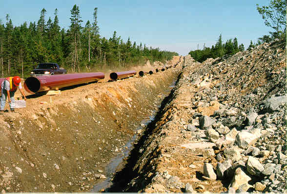
For a close-up view of the Beaver River Till, take a
virtual flier on the Maritimes and Northeastern Sable Gas Pipeline route.
----------------------
Canadian Family Stories
------------------
Blog
NOVA SCOTIA'S BLACK LOYALISTS-Canada's Checkerboard Army- Segregated Schools Nova Scotia -telling the truth-CANADA'S MILITARY- the honour, dignity, intelligence, duty- Boer, WWI WWII , Korea, Desert Storm, Afghanistan, UN Peacekeepers- CANADA PURE
-----------------------
Blog:
IDLE NO MORE CANADA- Can 10,000 YEARS of our beloved Aboriginals peoples of Canada languages be saved? Learning about Canada's 10,000 Years of our First Peoples culture 4 kids-Canada fun- FED.GOV.2003- see nothing changes much 4 our First People of Canada-talk,talk,talk
------------
BLOG:
CANADA- NOVA SCOTIA- Nouvelle-Écosse- history of Acadians -Nova Scotia
---------------------------
Blog
NOVA SCOTIA PURE-CANADA HISTORY-FACTS AND HUMOUR 1st Classified-Trews Georges Island Nova Scotia weekend- One Billion Rising Canada-break the chains- 2nd CANADA PROVINCE-TERRITORIES- flags-coats of arms, history- and THE BEST CANADIAN JOKES- Federal Government 2003 (smile)- 4 OUR MILITARY AND ALL Canadians- u gotta smile - stellar humour and Canadiana
---------------------------
Blogged – 2015
CANADA MILITARY NEWS: Feb25- Suicide- Teens -Vets beautiful young Canadians and ASSISTED Suicide Dying with dignity 4 the horribly ill and aged suffering needlessly - Who's 2 say- some questions- answers and food 4 thought -imho/Do know that God is holding our Canadian Soldiers of Suicide close whilst begging them 2 please stay on earth cause their work's not done- we need them and our children - O Canada
PTSD- This ad just won 'Best Commercial' in The Netherlands.
------------------
BLOGGED:
CANADA
MILITARY NEWS: Feb/Mar2014- Help Lines- SEND UP THE COUNT-
PTSD/SUICIDE/WOUNDED/LOVED/MISSED- Help Lines/Videos/Blogs/Photos
-------------------------
Blogged:
CANADA HISTORY OF WHITE SLAVERY/USA/EUROPE- WHITE SERVITUDE (Indentured Servant)...Iran's vicious cruelty (SHAME ON USA) against citizen.... NEDAS..... black Muslim slavery/ Jon Stewart's Rosewater and why it matters... AND THEN THEY CAME 4 ME.....Baha'i-To Light A Candle- and Education is NOT a Crime....#1BRising- why we are still here- Zahra Kazemi, Canadian Iranian Journalist raped, tortured beaten 2 death 4 taking pictures of Evin Prison/#Free Rafi- Saudi Arabia / Mohamed Nadel Fahmy- Canadian Egyptian (bring him home 2 Canada now/ so tired of global politicans (all) selling humanity's soul at the cost of our troops and everyday folks 4 UN $$$greed and war/EDWARD SNOWDEN WINS AN OSCAR
-------------------------
BLOGGED
CANADA MILITARY NEWS- Black History Nova Scotia and Canada honour, duty and
pride - these postings are from 2009 and some from 90s- WILLIAM HALL IS ONE OF
MY GREATEST HEROES- VICTORIA CROSS and a true Canadian Military hero... Rocky
Jones was another- blogged him- respect and honour /Viola Desmond honours women
and Canada/Ike and Tina Turner/Bob Marley... and Gottingen St. 60s and 70s/Incredible
Gibson Woods of Nova Scotia historical gem of Black History
-------------------------
BLOG
CANADA MILITARY NEWS- Nova Scotia-DEADMAN'S ISLAND- the War of 1812 Archives and USA and Canada data honour
-----------------------
Blogged june 29 2015
Canada Military News: History and Rules of our Flags/ Canada Day- /fun 4 kids/fun/facts/jokes for all/ a little history/ a whole lot of Canada-GETCHA CANADA ON FOLKS /God loves Canada and so do we
-------------------------
BLOG:
https://ns1763.ca/ Nova scotia’s best historical site
ever...done way back when research had so much value – simpatico was cool
1998
ns1763.ca
traffic statistics, monthly earnings and website value.
Find more data about ns1763.ca.
CANADA MILITARY NEWS- Nova Scotia-DEADMAN'S ISLAND- the War of 1812 Archives and USA and Canada data honour
------------------
BLOG:
CANADA MILITARY NEWS-Wheelchair Rights in Canada/Disabled have great sex lives and always have-global (July 11, 2015)Disability Rights in Canada March 25-2015/Disabilities- Know it 2 own it-Advocating your Rights on Campus... #Disability /Disabilities are abilities in disguise baby!
-----------------------
"We have a whole new year ahead of us - and wouldn't it
be wonderful if we could all be a little more gentle with each other - and a
little more loving - have a little more empathy - and maybe next year at this
time we'd like each other a little bit more." - JUDY GARLAND
--
Egypt el-Sissi inaugurates
cathedral, mosque in new capital
Egypt’s
president on Sunday inaugurated a new cathedral for the Coptic Orthodox Church
and one of the region’s largest mosques in a highly symbolic gesture at a time
when Islamic militants are increasingly targeting the country’s minority
Christians
The
ceremony, attended by Palestinian leader Mahmoud Abbas and a host of Arab
dignitaries, included recorded video messages of support from the region’s top
Christian clerics as well as Pope Francis.
----------------------
The
Palestinian Authority says it is withdrawing its officers from a key crossing
point between the Hamas-controlled Gaza Strip and Egypt.
Abbas
met with Egyptian President Abdel-Fattah el-Sissi in Cairo on Saturday.
---------------
“There are three things we want
to accomplish as part of a withdrawal,” Graham said. “We want to make sure
that, when we leave, the Kurds do not get slaughtered . . . We need to make
sure ISIS doesn’t come back once they’re defeated, and Iran is not the biggest
winner.”
----------
--------------------
All this technology is making us anticocial
-----
Electricity
from renewables topped coal in Germany for first time in 2018
------------------
A recent count by the Xerces Society recorded fewer
than 30,000 butterflies, which it said is an 86 percent decline since 2017.
By comparison, the group in 1981 counted more than
1 million western monarchs wintering in California, the San Francisco Chronicle
reported.
Anderson Cooper honored at
Sean Penn’s star-studded benefit
Women of French yellow vest
group counter violent image
Women
also marched in other cities around France.
Some
women tried to rebrand the movement as peaceful through signs reading “I am
your daughter” or “I am your Grandma.”
-------------