Cartier (1534-42) the French crown laid claim to all America
north of the sphere of Spanish influence- Nova Scotia- Little France

Seven Years War
a.k.a.
French and Indian War
Timeline
1754-1763 in North America
1756-1763 in Europe and India
The Seven Years War (1756-1763)
is one of the top ten wars in history
since the fall of the Roman Empire in 476 A.D.
One of the world's more complicated wars...
BBC's Guide to Life, The Universe and Everything
BBC's Guide to Life, The Universe and Everything
The period 2004-2013 is the 250th anniversary of the
Seven Years War, a.k.a. the French and Indian War.
The Seven Years War is the first world war,
with important battles in Europe and India,
as well as Africa and North America.
This timeline focuses mainly on events in North America.
| In Canada, the designation French and Indian War is nearly unknown.
English Canadians typically refer to the war as the Seven Years War, while French Canadians call it the Guerre de la conquete (War of the Conquest), since it is the war in which New France was conquered by the British and became part of the North American portion of the British Empire. More Wikipedia Seven Years' War Canadian Encyclopedia |
The French Colonization
|
| In Canada, there was nothing but a constant struggle against nature, still
mistress of the vast solitudes, against vigilant rivals and a courageous and cruel race of natives. The history of the French colonists in Canada showed traits and presented characteristics rare in French annals; the ardor of the French nature and the suavity of French manners seemed to be combined with the stronger virtues of the people of the north; everywhere, amongst the bold pioneers of civilization in the new world, the French marched in the first rank without ever permitting themselves to be surpassed by the intrepidity or perseverance of the Anglo-Saxons, down to the day when, cooped up within the first confines of their conquests, fighting for life and liberty, the Canadians defended foot to foot the honor of their mother country, which had for a long while neglected them, and at last abandoned them, under the pressure of a disastrous war conducted by a government as incapable as it was corrupt... As early as 1506 a chart of the St. Lawrence was drawn by John-Denis, who came from Honfleur in Normandy. Before long the fishers began to approach the coasts, attracted by the fur-trade; they entered into relations with the native tribes, buying, very often for a mere song, the produce of their hunting, and, introducing to them, together with the first fruits of civilization, its corruptions and its dangers. Before long the native people of America became acquainted with the fire-water... La Salle, in his intrepid expeditions (from 1669 to 1687), discovered – that is, performed the first European exploration of – Ohio and Illinois, navigated the Great Lakes, crossed the Mississippi...and pushed on as far as Texas. Constructing forts in the midst of the Indian districts, taking possession of Louisiana in the name of King Louis XIV... — Chapter LIII (53): Louis XV, France in the Colonies, 1745-1763 A Popular History of France From The Earliest Times, Volume VI c.1830 by Francois Pierre Guillaume Guizot Project Gutenburg |
The French went to Louisbourg in 1713 after ceding Acadia and
Newfoundland to the British through the Treaty of Utrecht, which ended
the War of the Spanish Succession. It wasn't long before the settlement
became a thriving community, mostly based on the salt cod trade, so
much so that by 1719, France had begun building fortifications to
protect its interests. The colony of Louisbourg in what is now Nova
Scotia became a hub of commerce, trading in manufactured goods and
provisions imported from France, Quebec, the West Indies and
New England. Life was good, for a while, anyway.
— National Post, 31 December 2008
— National Post, 31 December 2008
British colonization of the Americas Wikipedia
French colonization of the Americas Wikipedia
Scottish colonization of the Americas Wikipedia
Spanish colonization of the Americas Wikipedia
The French Settlement Of Vermont: 1609-1929 Elise A. Guyette
English Movement and Settlement: Connecticut River Valley 1691-1791
French colonization of the Americas Wikipedia
Scottish colonization of the Americas Wikipedia
Spanish colonization of the Americas Wikipedia
The French Settlement Of Vermont: 1609-1929 Elise A. Guyette
English Movement and Settlement: Connecticut River Valley 1691-1791
Map: United States Exploration before 1675 University of Texas
1590: The White-De Bry Map of Virginia U.S. National Park Service
1715: A New and Exact Map of the Dominions of the King of Great Britain on the Continent of North America, containing Newfoundland, New Scotland, New England, New York, New Jersey, Pennsylvania, Maryland, Virginia and Carolina University of Georgia
1733: A map of the British Empire in America, with the French and Spanish Settlements adjacent thereto University of Georgia
The Zenith Of The French Empire In North America Canadian Military Heritage
Timeline of Quebec history (1663 to 1759) Wikipedia
Brief Overview:
|
200,000 acres is about 300 square miles or 800 square kilometres.
|
The Ohio Country (sometimes called the Ohio Territory) was the name used in the 1700s for the regions of North America west of the Appalachian Mountains and in the region of the upper Ohio River south of Lake Erie – roughly corresponding to the present-day states of Ohio, eastern Indiana, western Pennsylvania, and northwestern West Virginia.
The effort to control the Ohio Country was the most direct cause of the French and Indian War.
The French, who had long claimed the Ohio Country as their territory, felt threatened by the Ohio Company's venture. In 1753, 1,500 French soldiers entered the disputed area and began work to build and improve several forts, including Fort Le Boeuf (1753), Fort de Chartres (1754) and Fort Machault (1756) – these three forts all were located on and protected the vital main transportation and communications corridor for France, between Canada (Quebec) and Louisiana.
Robert Dinwiddie, Virginia's lieutenant governor, upon hearing of France's actions, immediately sent George Washington and Christopher Gist to Fort Le Boeuf to persuade the French to leave. The French commander refused and told the Englishmen that the French would arrest any English (that is, non-French European) settlers or merchants entering the Ohio Country.
French and Indian War Ohio History Central
Ohio Country Ohio History Central
France and Britain both laid claim to North America's vast interior. The chief battleground for their struggle over the continent was the Ohio Valley. In the 1740s, French authorities were alarmed by the activities of British traders from Pennsylvania and Virginia among the Native Americans in the Ohio Valley and the building of a fort at Oswego on Lake Ontario and a military base in Halifax, Nova Scotia...
The Fall of New France Library of Congress
The purpose of the Ohio Company was to divert the trade with the Indians north of the Ohio, and its headwaters, (which hitherto, the French and Pennsylvanians had enjoyed) southward, by the Potomac route, and to settle the country round the head of the Ohio with English colonists from Virginia and Maryland. To this end, the King of England granted to the Company five hundred thousand acres of land west of the mountains, "to be taken chiefly on the south side of the Ohio, between the Monongahela and Kanawha, but with privilege to take part of the quantity north of the Ohio. Two hundred thousand acres were to be taken up at once, and to be free of quit rents, or taxes to the king for ten years, upon condition that the company should, within seven years, seat one hundred families on the lands, built a fort, and maintain a garrison and protect the settlement"... Thus many settlements were made on lands which were supposed to be in Virginia which were afterwards disclosed to be within the charter limits of Pennsylvania...
— Report of the Commission to Locate the Site of the Frontier Forts of Pennsylvania
Chronology: France in America Library of Congress
Background of the Conflict United States National Park Service
Life, Liberty and the Pursuit of Land by Daniel M. Friedenberg
"...a wonderful antidote to the white-washed history we all got fed
in early school years. I strongly recommend reading this work."
More Canadian Military Heritage
Canada (Quebec) and Louisiana together did not number eighty thousand inhabitants, whilst the population of the English colonies already amounted to twelve hundred thousand souls...
Source: Chapter LIII (53): Louis XV, France in the Colonies, 1745-1763
A Popular History of France From The Earliest Times, Volume VI c.1830
by Francois Pierre Guillaume Guizot Project Gutenburg
New France Canadian Encyclopedia
1739 - 1749
French military expeditions explored and mapped the Ohio River valley.
These expeditions were led by Le Moyne and Celeron 1739
and Celeron and Bonnecamps 1749 (the lead plate expedition).
French military expeditions explored and mapped the Ohio River valley.
These expeditions were led by Le Moyne and Celeron 1739
and Celeron and Bonnecamps 1749 (the lead plate expedition).
The Wayback Machine has archived copies of this document:
1739 Delongueuil Expedition
Archived: 2005 April 28
http://web.archive.org/web/20050428181928/http://www.jamestownny.net/pr_markers.php?id=1
Archived: 2006 January 05
http://web.archive.org/web/20060105232214/http://www.jamestownny.net/pr_markers.php?id=1
These links were accessed and found to be valid on 10 January 2010.
|
The Wayback Machine has archived copies of this document:
1749 Celeron Expedition
Archived: 2005 May 02
http://web.archive.org/web/20050502035737/http://www.jamestownny.net/pr_markers.php?id=2
Archived: 2006 January 05
http://web.archive.org/web/20060105222235/http://www.jamestownny.net/pr_markers.php?id=2
These links were accessed and found to be valid on 10 January 2010.
|
...the French and Indian War or Seven Years' War, was a struggle to decide
whether the French or English should control the continent of North
America. The treaty of Aix-la-Chappelle, signed in 1748, amounted to a
little more than a cessation of hostilities or a truce.
The English colonists occupied a long narrow line of territory from Newfoundland along the Atlantic coast to Georgia. The French had possession of two of the chief rivers of the country, the St. Lawrence and the Mississippi, and had built fort after fort until they had a line extending from Quebec to Loulsiana, and were in possession of what is now the western part of New York, Pennsylvania, western part of Virginia and all the countries between the territory named and the Mississippi.
After all the important points had been taken up by the French, the English began to awake from their slumber, and they saw that unless they undertook heroic measures they would lose the heart of the continent, and with the French at the west of them must confine their settlements to the Atlantic coast. In order to prevent this environment by the French, a company was formed in 1748 for planting a colony along the upper Ohio River.
A glance at the map shows that the territory from the city of Erie on Lake Erie in Pennsylvania to a junction of the Alleghany and Monongehela Rivers is the gateway of the west. Both parties realized the importance of this territory. The French already occupied it. The Ohio company, realizing that they must hold by force, began the construction of a fort where the city of Pittsburg, Pennsylvania, now stands, but before they could finish it the French drove them away, then completed the fort and named it Fort Duquesne. Matters looked serious, so much so that a convention of the northern colonies met at Abany in 1754, to consider what must be done...
Chapter XII: History of the Town of Goffstown, New Hampshire
by George P. Hadley, 1922
By the 1730s and 1740s, British America had a number of cities (Boston,
Philadelphia, New York...) with diversified social structures,
newspapers, professional middle classes etc. rooted in the economy and
society of their hinterlands. By contrast, Quebec City was mainly an
administrative center for the official bureaucracy of New France, and
Montreal was not much more than a large trading post. There was not a
single printing press in New France. (French printing in Canada
commenced under British rule.)
Seven Years War
|
The Big Picture
Considering the enormous length of the French possessions in North
America, stretching, as they did, in a curved line from Louisbourg,
through Quebec, across Lakes Ontario and Erie and down the Ohio and
Mississippi Rivers to New Orleans, it is remarkable at how few points
they were exposed to effective invasion. By sea there were only two
ways: the mouth of the Mississippi River and the mouth of the
St. Lawrence River. The former would lead the invader nowhere; there
would still be thousands of miles of wilderness to traverse in order to
reach Quebec, the heart of the whole system. The latter way was guarded
by the Fortress of Louisbourg, in the 1740s and early 1750s the
strongest fort in all of North America. By land – disregarding the isthmus of Chignecto
between French and English Acadia, which would lead only to a
peculiarly difficult tract of wilderness – there were at most three
avenues of attack: (1) the old war-way up the Hudson River and down the
Richelieu River, leading directly from New York to Montreal;
(2) a branch line from the Hudson along the Mohawk River to
Lake Ontario; and (3) the Potomac-Monongahela-Allegheny route to
Lake Erie.
The English colonies were exposed to land attack from the French by way of the same routes but their main vulnerability was by sea – the whole Atlantic coast was wide open from Georgia to Maine. The French had a huge geographical advantage.
Politically, also, the French were in the better position. French society in North America was a single unit with one governor (or at most two, including Louisiana) in complete control.
The thirteen English colonies, by contrast, were almost miniature republics, disunited, jealous of one another, and suspicious of the mother country. They hardly ever agreed on anything (except that none of them liked taking orders from London). With the occasional exception of the New England provinces, it was next to impossible to get them to work together towards a common end. Residents of any one colony showed interest in supporting military action only if an immediate threat was on their doorstep. The more southern provinces (Virginia, North Carolina, South Carolina, Georgia) in particular, far removed from the area of possible collision, could not be made to see the impending danger from the French at Fortress Louisbourg, then by far the strongest military base anywhere in North America. They were quite content to allow their northern brethern to act as buffer states between them and danger. It was only when the French occupation of the Ohio valley threatened the line of the Potomac that Virginia and her neighbours began to wake up. Thus the advantage of the enormous superiority of the English population over the French was neutralized by their apathy and lack of union. Parkman described the situation perfectly in Chapter Two of his book Montcalm and Wolfe
“In the heterogeneous structure of the British colonies, their clashing interests, their internal disputes, and the misplaced economy of penny-wise and short-sighted assembly-men, lay the hope of France. The rulers of Canada [Quebec] knew the vast numerical preponderance of their rivals; but with their centralized organization they felt themselves more than a match for any one English colony alone. They hoped to wage war under the guise of peace...”
With this indifference and lack of union among the English, compared to the united direction and resolve on the part of the French added to their better geographical position from a military point of view, how could the French lose? What could go wrong?
— Excerpted and adapted from A History of Canada (page 151) by James Bingay, published 1934 by Thomas Nelson and Sons, Toronto

On 25 October 1743 France signs a treaty known as the Second Family
Compact with Spain and on 15 March 1744 joins Spain's war against
England. In May 1744, the French capture the British fort at Canso and
two months later, in July, make an unsuccessful assault on
Annapolis Royal, both in Nova Scotia. On 16 June 1745 Sir Peter Warren captures Fort Louisbourg – his expedition is funded mainly by Massachusetts. The French incite Indian raids into Maine while Sir William Johnson leads his Iroquois warriors into Canada [Quebec]. The French retaliate by burning Saratoga, New York, in late November 1745...
1744 May 24
France attacks and captures British fort at Canso
Massachusetts Governor tries to meet the French threat
In 1744, colonial North America is again plunged into a war precipitated
by yet another succession crisis in Europe. On this occasion, it is
the War of the Austrian Succession, a war for which the British in Nova
Scotia are ill-prepared. Twenty-five years of neglect by Britain has
left the defences of the colony in a wretched condition. Canso is
virtually defenceless, while the fort at Annapolis Royal is, in the
words of Lieutenant-Governor Mascarene "apt to tumble down in heavy rains or in thaws after frosty weather." Mascarene's fears are soon to be realized.
France makes the first move
War against England is declared by France on 11 March 1744 and by
England against France on 9 April 1744. The French at Louisbourg,
getting the news first (a ship from St. Malo) that England and France
are at war, are quick to strike. On 24 May 1744, a force of 350 French
and Micmacs, under the command of Francois Dupont du Vivier, captures the rickety British fort at Canso
and sends the garrison into captivity at Louisbourg... In desperation,
Paul Mascarene, administrator and commander in chief of the Province of
Nova Scotia, appeals to Governor William Shirley
of Massachusetts for 200 reinforcements. Shirley is unable to persuade
the Massachusetts House of Representatives to send the 200 requested
but does manage to send a reinforcement of 70 unarmed men... Despite
his difficulties, Mascarene manages to hang on to the fort at
Annapolis... The year 1744 ends with the British still maintaining a
toehold in Nova Scotia... Mascarene writes to the Lords of Trade: "This
shews how much the preservation of this place is owing to the
reinforcement we have received from the Province of the Massachusetts
Bay..." The resumption of war elicits a vigorous response from
Massachusetts. Governor William Shirley,
anticipating the outbreak of war, undertakes a number of measures to
ensure the safety of the colony. He organizes companies of rangers to
counter and pursue potential Indian raiding parties and places the
militia in a state of readiness. In addition, he directs that
blockhouses be built along the northern perimeter of the colony and that
protection be provided in Maine for the settlers... Late in 1744,
Governor Shirley begins to formulate plans for an expedition against the
great French fortress of Louisbourg on Cape Breton Island...
— The Struggle for Acadia: The Final Phase 1744-1779 by W.E. Daugherty
Indian and Northern Affairs Canada
— The Struggle for Acadia: The Final Phase 1744-1779 by W.E. Daugherty
Indian and Northern Affairs Canada
The French commander at Louisbourg was the one-legged naval officer Jean-Baptiste-Louis le Prévost DuQuesnel,
who had been appointed to that post on 1 September 1740 and had arrived
at Louisbourg on 3 November 1740. We can only imagine what went
through Prevost's mind as he greeted the ship captain fresh in from
St. Malo on that early May day, in 1744, when he heard the captain's
news: "France and England are at war!" Upon being convinced (maybe
because of the short passage time the French captain experienced) that
the English in America had yet to receive the news, Prevost thought, if
he were to act fast he would have an advantage. As it was, the French
could not afford to mount a large force, however, Prevost calculated
that a large force was not needed because he would have the element of
surprise on his side, further, the intelligence was that the English at
Canso were few and had little in the way of defensive work in place. So
it was that Le Prevost, the commandant at Louisbourg, felt the need to
involve himself and the Louisbourg garrison in a little warfare. Some
at Louisbourg thought it to be a "foolish enterprise" and "tried in vain
to dissuade him"; but Prevost had his way and the decision was taken to
send an expedition to Canso, only a short sail down the coast. Prevost
put a locally born officer in charge, one whose family goes back to the
earliest times of Acadia, a 37 year old captain by the name of Joseph Du Pont Duvivier.
Thus, in the greening month of May 1744, Louisbourg was busy with men
and supplies spilling down the streets to the docks and out onto the
waiting vessels. For the first time since its founding in 1713,
Louisbourg was mustering its forces for the real thing; this great
defensive fortress was now to involve itself in an offensive effort.
Canso was to be French, as it ought to be; and, so too, soon, if these
enthusiastic Frenchmen were to have their way – all of Acadia.
Louisbourg, for the most part, was in high spirits as a sizable number
of her military men sailed off. On 13 May 1744, a force of 357 French
soldiers were carried in a flotilla of small boats to Canso. In
preparation for the French landing, two Louisbourg privateers began to
bombard the English blockhouse with cannon-shot. When the first shot
sailed through the thin blockhouse walls, the English commander, Heron,
rushed out with a flag of truce, thinking "it advisable to capitulate
in time to obtain the better terms." The place was then taken over by
the French and they burned all the wooden works to the ground; the
English prisoners were brought back to Louisbourg. Correspondence was
then carried on between the governors, Prevost at Louisbourg and Shirley
at Boston, about what was to be done with the British prisoners...
— The Struggle for Acadia: The Final Phase 1744-1779 by Peter Landry
Jean-Baptiste-Louis le Prévost DuQuesnel by Peter Landry
Jean-Baptiste-Louis le Prévost DuQuesnel Dictionary of Canadian Biography
Jacques Prevost de La Croix Dictionary of Canadian Biography
Joseph Du Pont Duvivier Dictionary of Canadian Biography
Joseph Du Pont Duvivier by Peter Landry
Francois Du Pont Duvivier Dictionary of Canadian Biography
Francois Du Pont Duvivier Wikipedia
Canso Timeline, 1713-1744 Industry Canada archive
Grassy Island National Historic Site
Raid on Canso Wikipedia
Grassy Island National Historic Site
Raid on Canso Wikipedia
Chapter 7, The Lead-Up, Annapolis Royal and War by Peter Landry
William Shirley, Governor of Massachusetts by Peter Landry
William Shirley, Governor of Massachusetts Wikipedia
Paul Mascarene, Acting Governor of Nova Scotia by Peter Landry
Paul Mascarene, Acting Governor of Nova Scotia Wikipedia
Paul Mascarene Dictionary of Canadian Biography
William Shirley, Governor of Massachusetts by Peter Landry
William Shirley, Governor of Massachusetts Wikipedia
Paul Mascarene, Acting Governor of Nova Scotia by Peter Landry
Paul Mascarene, Acting Governor of Nova Scotia Wikipedia
Paul Mascarene Dictionary of Canadian Biography
View of the port and town of Louisbourg in August 1744 Canadian Military Heritage
View of the harbour at Louisbourg in August 1744 Canadian Military Heritage
View of the harbour at Louisbourg in August 1744 Canadian Military Heritage
1744 August - October
France sends expedition to capture Annapolis Royal
The last remaining toehold of Great Britain in Nova Scotia
At the outbreak of the hostilities between France and Great Britain – which became King George's War – François Du Pont Duvivier
was chosen to command a raiding party of 350 men in an attack on the
British settlement at Canso. After the success of this raid Duvivier
was charged with the task of raising an Acadian and Mi'kmaq army to
capture Annapolis Royal, the last remaining foothold of Great Britain in
Nova Scotia. Having achieved less then expected success in gathering
these forces, Duvivier arrived at Annapolis Royal with an inadequate
army to force a surrender. After laying siege to the settlement for
nearly a month he received word that reinforcements and naval support
from Louisbourg would not arrive, forcing him to break siege and return
to Isle Royale.
— Francois Du Pont Duvivier Wikipedia
— Francois Du Pont Duvivier Wikipedia

Route taken by François Du Pont Duvivier's expedition
to capture the fort at Annapolis Royal, August to October, 1744
by Raymond Thériault, Course à L'Accadie
Centre d'études acadiennes, Université de Moncton
Centre d'études acadiennes, Université de Moncton
Regular business at Louisbourg was put aside temporarily when
the easy victory at Canso persuaded the French to attempt the capture of
Annapolis Royal... On 29 July 1744, Duquesnel dispatched François Du
Pont Duvivier from Louisbourg to Nova Scotia with 50 colonial regulars,
an undetermined number of Isle Royale Micmacs, and the expectation that
the warships of a small naval squadron would soon appear. Having landed
at Baie-Verte (New Brunswick) on 8 August 1744, Duvivier cast himself
as the Acadian liberator back among his own, but despite strong
emotional appeals along the route to Annapolis Royal, he succeeded in
detaching no more than a dozen Acadians from the strict neutrality which
by this time had become the practical expedient of government and
governed in Nova Scotia. Keenly disappointed, he retaliated with
threats which served only to alienate the Acadian community. He fared
little better with the Indians... only 230 Micmacs and Malecites rallied
to his side on 7 September, the day he attacked the British fort at
Annapolis. The siege lasted a full four weeks. Despite decided
tactical and psychological advantages, the French effort was compromised
from the start by Duvivier's singular lack of offensive spirit. Aided
not a little by the ailing Duquesnel's ambiguous, even contradictory,
communications from Louisbourg (instructing him to attack if a
favourable occasion presented itself, but not to take unnecessary
risks), Duvivier adamantly refused to seize the opportunity afforded by
the decrepit state of the British fort and the low morale of its
garrison.
The garrison at Annapolis Royal, which consisted of no more than 75 able-bodied soldiers, was commanded by Lieutenant Governor Paul Mascarene. Shrewd, practical, and courageous, Mascarene inspired an effective and confident defence. His efforts were considerably assisted by the arrival on 26 September of two vessels bringing reinforcements and supplies from Boston. Although the morale of his detachment was shaken, Duvivier refused to withdraw. The fate of the French effort, however, was sealed abruptly on 2 October with the arrival from Louisbourg of Michel de Gannes de Falaise bearing the news that the naval squadron had not sailed and the order to withdraw to winter quarters at Minas. Duvivier feigned disgust at the prospect of retreat, but Duquesnel's order was in reality fortunate for him because it enabled him to divert attention from his own indecisiveness...
— Francois Du Pont Duvivier Dictionary of Canadian Biography
1744 Summer and Autumn
Massachusetts spars with France
Not war, but certainly not peace
Edward Tyng
was commissioned captain of the south and north batteries and
fortifications in Boston on 16 April 1740. On 26 August 1740, Tyng
assumed command of the province's (Massachusetts) new snow, Prince of Orange.
For the next two years he cruised the New England coast in search of
Spanish and French privateers. In the spring of 1744 Captain Tyng was
sent from Boston to Annapolis Royal with news of the outbreak of war
with France. He returned to Boston on 27 May 1744, carrying 26 women
and children refugees, as the Annapolis garrison feared an attack by the
French and their Indian allies. In June 1744 Tyng set out in search of
French privateers off the New England coast. While cruising off Cape
Cod he met French ship Cantabre commanded by Captain Joannis-Galand d'Olabaratz
– who owned it together with the infamous Intendant Francois Bigot and
the one-legged Le Prevost, Governor of Louisbourg – after a 12-hour
engagement, Tyng captured the smaller vessel
and took it as a prize. The people of Boston were much impressed as
Tyng took his prize and its 93-man crew into Boston harbour. Captain
Tyng brought badly needed supplies and men to the besieged Annapolis
Royal in September of 1744.
Captain Edward Tyng by Peter Landry
Edward Tyng Dictionary of Canadian Biography
Captain Edward Tyng by Peter Landry
Edward Tyng Dictionary of Canadian Biography
1744 December 27
Mutiny at Fortress Louisbourg
Almost the entire garrison of Louisbourg took part in the mutiny. The
complaints of the mutineers were reasonable. The Swiss wanted better
living conditions. The French made the same demand in addition to
complaining about the abuses of certain officers and officials. The
soldiers also wanted more wood for heating, better rations, the clothing
due to recruits, and the booty to which the soldiers who had
participated in the capture of Canso in May were entitled. The
commissary, Francois Bigot,
acceded to their demands, while the governor and the officers succeeded
in calming the atmosphere. Order was re-established, if not
discipline, and no blood was shed as a result of the mutiny, though some
officers were forced at bayonet point to listen to their men's
complaints. Although no violence ensued, this mutiny was the largest
among the colonial troops of the Ancien Regime.
Mutiny at Louisbourg Canadian Military Heritage
François Bigot Dictionary of Canadian Biography
Mutiny at Louisbourg Canadian Military Heritage
François Bigot Dictionary of Canadian Biography
1745 February 5
Massachusetts decides to attack Fortress Louisbourg
During the fall and winter of 1744-1745, Governor William Shirley, of
colonial Massachusetts, campaigns to convince New Englanders that an
attack on the fortress of Louisbourg in Nova Scotia is practical. On
5 February 1745, the Massachusetts House of Representatives approves a
plan to move against French-held Louisbourg in conjunction with the
other British colonies. The colonies quickly raise a land force,
Massachusetts being in the lead with seven regiments. William
Pepperell, a wealthy merchant from Kittery, Massachusetts (now Maine),
becomes the expedition's commander. In April of 1745 the troops embark
for Nova Scotia and by May have laid seige to the fortress, which
surrenders on June 17...
— Bourne family: Massachusetts military papers
Given in 1896 to Houghton Library, Harvard College Library, Cambridge, Massachusetts
— Bourne family: Massachusetts military papers
Given in 1896 to Houghton Library, Harvard College Library, Cambridge, Massachusetts
The crowning event of King George's War – the seige and capture of
Louisburg – is "the most important military exercise ever undertaken by
the English Colonies in America". France had fortified Louisburg at
enormous expense. It was the richest American jewel that had ever
adorned the French crown. Its situation for the protection of Canada
(Quebec) was excellent, and it was an advantageous strategic point from
which to harass the contiguous English-American colonies. Massachusetts
and Nova Scotia in particular began to feel the destructive power of
the French, and the Massachusetts Bay government was virtually
responsible for the preservation of the latter. William Vaughn, son of
the Lieutenant-Governor of New Hampshire province, was, without doubt,
one of the first to suggest an expedition against Louisburg, and he
played a not uncertain part during its progress and and in its
successful issue. But to Governor Shirley of Massachusetts Bay must be
awarded the honor of the first official act in the matter. He urged it
upon the various legislatures (Massachusetts, New Hampshire, Connecticut
and Rhode Island). Singularly enough, his own legislature, after some
hesitancy, agreed to the expedition by a majority of only one vote...
The American Historical Review, v5 n1 October 1899, pages 137-139
Review by Victor Hugo Paltsits, of:
Collections of the Massachusetts Historical Society, Boston, 1899
Sixth Series, volume X: Pepperell Papers
The American Historical Review, v5 n1 October 1899, pages 137-139
Review by Victor Hugo Paltsits, of:
Collections of the Massachusetts Historical Society, Boston, 1899
Sixth Series, volume X: Pepperell Papers
William Vaughan Dictionary of Canadian Biography
1745 April 30
4000 New England troops arrive and go ashore
About one hundred New England vessels, of all sorts, were assembled at
Canseau in
April 1745. Governor Shirley had instructed Pepperell to have all of
these vessels arrive near Louisburg at the same hour, in the night and
no matter what might then be the condition of the surf, to land all the
troops on the rocky shore before daylight, march at once through
thickets and over morasses to the city and beyond it, and to take the
fortress and town by surprise. Of course a strict compliance with these
orders was impossible, but it was undertaken. The vessels all left
Canseau, bearing about four thousand troops, and early in the morning of
the 30th of April 1745 appeared in Gabarus Bay, eastward of Louisburg.
The troops were disembarked on the same day, and most of the artillery,
ammunition, and provisions were landed. The alarm bells of the city
were rung, and cannon from the fortress were fired to warn the suburban
inhabitants of danger...
— Connecticut troops under Roger Wolcott help capture Louisburg
The Society of Colonial Wars in the State of Connecticut, New Haven
— Connecticut troops under Roger Wolcott help capture Louisburg
The Society of Colonial Wars in the State of Connecticut, New Haven
On 12 June 1745, Commodore Peter Warren commanded the largest British squadron in North American waters since 1711...
Warren's Fleet at Louisbourg, 1745 by Peter Landry
Warren's Fleet at Louisbourg, 1745 by Peter Landry
A Plan of the City and Fortress of Louisbourg Boston, 1746
Massachusetts Historical Society
Massachusetts Historical Society
(1) New England Vessels in the Expedition Against Louisbourg, 1745
by Howard Millar Chapin
(2) New England Vessels in the Expedition Against Louisbourg, 1745
by Howard Millar Chapin
by Howard Millar Chapin
(2) New England Vessels in the Expedition Against Louisbourg, 1745
by Howard Millar Chapin
The Louisburg Expedition excerpts from Journal and Letters Samuel Curwen, 1842
Born at Barnstable, Massachusetts, on 12 December 1709, John Gorham
began working on ships operating out of the port before he had turned
twenty, trading at various ports in Canada, and he was occasionally
involved in land speculation in Nova Scotia and Maine. Following the
family pattern, however, he entered into military service before 1741.
At the outbreak of King George's War in 1744, Gorham organized a group
of about fifty Rangers in New England that was sent to reinforce the
garrison at Annapolis Royal, Nova Scotia. Gorham's Rangers, mostly
Mohawks or persons of mixed-blood, were a highly successful free-ranging
unit that employed "unorthodox" tactics — i.e., those not commonly
employed by British regulars — including the applied use of terror.
Their arrival at Annapolis Royal shifted the military balance in favor
of the English, and for this, Gorham received wide recognition. His
Rangers rapidly gained a fearsome reputation among the French and
indigenous populations. Early in 1745, Gorham returned to Massachusetts
to recruit additional Rangers, and was persuaded by Governor Shirley
and William Pepperell to join the expedition against Louisburg and
Ile Royale. At their request, Gorham accepted a commission as Lt. Col.
of the 7th Massachusetts Regiment commanded by his father. John Gorham
organized the landing at Gabarus Bay on 30 April 1745 and, along with
Lt. Col. Arthur Noble, led the failed assault on the Island Battery on
23 May 1745. With his father's death on 20 February 1745/46 OS (3 March
1746 NS), he was promoted to Colonel of the 7th Massachusetts and
remained in effective command of New England forces at Louisburg until
April 1746...
— John Gorham: Background Note
William L. Clements Library, University of Michigan
— John Gorham: Background Note
William L. Clements Library, University of Michigan
1745 June 16
Massachusetts captures Fortress Louisbourg
Louisbourg was a large French settlement founded in 1713, fortified in
the 1730s, besieged twice by New Englanders and the British, and finally
demolished by the British and abandoned in the 1760s. (The name is
sometimes spelled "Lewisburg" or "Lewisburgh" in contemporary documents,
both in New England and in Nova Scotia.)
When the Treaty of Utrecht (1713) established British control of
mainland Nova Scotia and confirmed British title to Newfoundland, the
French moved to Ile Royale (Cape Breton Island). The colony of
Ile Royale included the islands of Ile Royale and Ile Saint Jean (Prince
Edward Island). Ile Royale, particularly Louisbourg, was intended to
replace Placentia, Newfoundland, as the headquarters for the French
fishery and serve as a haven for trading ships. Louisbourg became a
major entrepôt.
Much of Ile Royale's fish was marketed in Europe and the Caribbean. By
the 1740s Ile Royale was selling large quantities of cod each year to
the West Indies. The colony also became a market for Caribbean
products. Shiploads of sugar, molasses and rum were brought to
Ile Royale and immediately re-exported, primarily to the British
American colonies. So extensive was the trade in rum and molasses that,
by the 1750s, the value of Ile Royale sugar products rivalled the value
of the colony's codfish production....
— History of Louisbourg, Fortress Louisbourg Association
http://www.fortressoflouisbourg.ca/archaeologyE/SiteInformation.html#HistoryFortress
— History of Louisbourg, Fortress Louisbourg Association
http://www.fortressoflouisbourg.ca/archaeologyE/SiteInformation.html#HistoryFortress
Louisbourg is now a small town, population about 1200, on the Atlantic shore of Cape Breton Island, Nova Scotia.
Louisbourg
started out in 1713 as a base for the flourishing French cod fishery,
but as the town prospered Louisbourg developed into one of the most
important ports in New France. By the 1730s Louisbourg was one of the
busiest seaports in North America – only Boston and New York had more
shipping traffic. By the 1740s Louisbourg's year-round population was
about 3000. In addition to its economic and commercial importance,
Louisbourg was the capital and administrative centre of Ile Royale,
which included Cape Breton Island and Prince Edward Island. From 1717
to 1758, this was the site of the great Fortress of Louisbourg,
built by the government of France as its strongest fortress in
America. In the 1740s and 1750s, Louisbourg was one of the most heavily
defended sites on the North American continent. The fortress was
designed using methods and principles established by great French
military engineer Vauban, the chief engineer of Louis XIV. French privateers, using the harbor as a base, preyed on New England fishermen working the Grand Banks
– until 1745, when a small force of New Englanders under William
Pepperrell, supported by a fleet of merchant men commanded by Sir Peter
Warren, attacked Louisbourg from the land. The attackers knew all about
the fatal weakness of the fortress – it was designed to resist
artillery bombardment only from the seaward side, and was vulnerable
from the rear. The attack was successful; the French garrison was
forced to surrender. Three years later, in exchange for Madras in
India, Louisbourg was returned to France by the Treaty of
Aix-la-Chapelle – thus enraging Massachusetts. In 1758 it was again
captured by a British land and sea attack led by General Jeffery Amherst and Admiral Boscawen.
To ensure that it would never again be a threat to New England, Britain
demolished the fortress in 1760. After the British blasted the massive
fortifications to smithereens, in 1760, not much could be seen at the
site for two hundred years. It was forgotten until the 1950s. A
rebuilding program began in 1961, and it is now a National Historic Site
of Canada.
Sir William Pepperrell Dictionary of Canadian Biography
William Pepperrell Wikipedia
Sir Peter Warren Dictionary of Canadian Biography
Peter Warren Wikipedia
Sir William Pepperrell Dictionary of Canadian Biography
William Pepperrell Wikipedia
Sir Peter Warren Dictionary of Canadian Biography
Peter Warren Wikipedia
Paris was stunned that its strongest North American post could be taken
by an untrained army of provincials. Boston, however, received the news
with joyous celebrations. And London, for its part, was overjoyed at
word of Louisbourg's capture. Honors, tributes and testimonials were
heaped upon the victors. Warren was promoted to the rank of rear
admiral. Pepperrell became a baronet and, along with Governor Shirley,
was given the right to raise regiments, an honor that provided
remuneration as well as status...
— Louisbourg: The Siege of 1745 by B.A. Balcom
— Louisbourg: The Siege of 1745 by B.A. Balcom
By 1738 the fortifications were just about complete. There were 580 troops at Louisbourg, 100 of whom were Swiss...
Chapter 2, Louisbourg: Its Soldiers & Fortifications by Peter Landry
Chapter 2, Louisbourg: Its Soldiers & Fortifications by Peter Landry
The reputation of the fortress of Louisbourg on Cape Breton Island is a
formidable one. In the mid-1700s it was considered to be impregnable;
and more recent historians, in referring to it as the Gibraltar of North
America, can record nothing but amazement at the accomplishments of the
expedition undertaken by the New England colonies in 1745... The
construction of the fortress of Louisbourg came about as a direct result
of the signing at Utrecht in 1713 of the treaty which ended the War of
the Spanish Succession. The treaty, as it affected North America, could
hardly be considered a French victory. Its terms forced France to
recognize British control of the Hudson's Bay area and to cede to
Britain control of Acadia (now Nova Scotia, New Brunswick, and part of
eastern Maine). France did manage to obtain one concession which was to
prove of great importance – the retention of Isle Royal (Cape Breton
Island). The loss of Acadia had left unprotected the Gulf of
St. Lawrence, the main route to Quebec. But the government of France
felt that the construction of a fortress and naval base on Cape Breton
Island would enable them to protect the heart of New France, and at the
same time to harass British vessels – especially those engaged in the
fishing industry. Time was to prove the French correct. Their
fortress, constructed in the years following 1713, became a threat to
the prosperity of the British colonies in New England, and in the fears
of New Englanders at least, a threat to their very existence...
— Louisbourg, 1745, by Robert Emmet Wall, Jr.
The New England Quarterly, v37 n1, March 1964
— Louisbourg, 1745, by Robert Emmet Wall, Jr.
The New England Quarterly, v37 n1, March 1964
First Siege of Louisbourg, 1745 by Peter Landry
First Government Lottery
The first authorized lottery in Colonial America took place in 1745 in
Boston, Massachusetts. In the previous year Massachusetts (which then
included the area that is now Maine) was compelled to spend a large sum
of money defending the frontier and seacoast as well as being required
to protect the royal province of Nova Scotia – mainly by mounting a
combined British and colonial military force sent to attack the French
stronghold of Fort Lewisburg on Cape Breton Island, Nova Scotia. The
colonists had already been subjected to unusually high poll and estate
taxes, but part of the military debt was still outstanding. On January 9, 1744/45 (o.s.) the General Court
of Massachusetts passed an act that provided for the payment of the
debt, "in a manner the least burdensome to the inhabitants," that is, by
a lottery. Each ticket cost 30 shillings O.T. (Old Tenor). 25,000 tickets were printed... The drawing of the lots took place at Faneuil Hall in Boston beginning on June 7, 1745...
— The First Colonial Government Lottery, Massachusetts 1744-45
The colony of Massachusetts had borne considerable expense in equipping the British military expedition against Fort Lewisburg and hoped the king would repay them for their expenses. It was thought the lottery would ease this financial burden but, as late as May 1745 many tickets remained unsold. If some tickets were not sold the lottery would lose money, and would actually increase the financial burden on the colony. However, all the tickets were finally sold by the start of the lottery drawing so the lottery was a success. (In 1749 King George II finally repaid Massachusetts – 21 tons of silver – for their expenses in the Lewisburg expedition of 1745.)
— Massachusetts 1744-45 Lottery
Quebec is apprehensive
The capture of Louisbourg and of the Island of Cape Breton by the
English colonists, in 1745, profoundly disquieted the Canadians. They
pressed the government of France to make an attempt upon Acadia. "The
population has remained French," they said; "we are ready to fight for
our relatives and friends who have passed under the yoke of the
foreigner." In 1746, the ministry sent the Duke of Anville with a
considerable fleet; storms and disease destroyed vessels and crews
before it had been possible to attack. In May 1747, a fresh squadron,
commanded by the Marquis de La Jonquiere, encountered the English off Cape Finisterre
in Spain. Admiral Anson had seventeen ships, M. de La Jonquiere had
but six; he, however, fought desperately. "I never saw anybody behave
better than the French commander," wrote the captain of the English ship
Windsor; "and, to tell the truth, all the officers of that
nation showed great courage; not one of them struck until it was
absolutely impossible to manoeuvre." The remnants of the French navy,
neglected as it had been through the unreflecting economy of Cardinal
Fleury, were almost completely destroyed, and England reckoned more than
two hundred and fifty ships of war...
— Chapter LIII (53): Louis XV, France in the Colonies, 1745-1763
A Popular History of France From The Earliest Times, Volume VI c.1830
by Francois Pierre Guillaume Guizot
Project Gutenburg
— Chapter LIII (53): Louis XV, France in the Colonies, 1745-1763
A Popular History of France From The Earliest Times, Volume VI c.1830
by Francois Pierre Guillaume Guizot
Project Gutenburg
Rhode Island pays part of the cost
of the Louisbourg expedition of 1745
In February 1744/45,
£2,500 in new tenor bills were emitted (by His Majesty's Colony of
Rhode Island) on account of the Cape Breton expedition, and in September
1745, £5,000 more of the same form. In June 1746, £11,250 new tenor
were emitted (issued) on account of the Canada (Louisbourg)
expedition... The success of the counterfeiters of bills of public
credit caused the passage of a savage act in 1743. Any person convicted
of the offence of counterfeiting the bills of any of the New England
governments was to have his ears cropped; to be branded with an R
on each cheek; to be imprisoned at discretion; to pay double damages
and double interest on the amount of the bills while in the possessor's
hands and his real and personal estate was to be forfeited to the
colony. If without estate he was to be set at work or sold for a term
of years...
— Chapter XVIII: ...Rhode Island Currency and Banking in the Province of the Massachusetts Bay, by Andrew McFarland Davis, 1901
Dinsmore Documentation Project
— Chapter XVIII: ...Rhode Island Currency and Banking in the Province of the Massachusetts Bay, by Andrew McFarland Davis, 1901
Dinsmore Documentation Project
The royal colony of Rhode Island spent a total of £18,750 to help
pay for the attack and capture of the Louisbourg Fortress in 1745. To get some idea of just how big this cost was, expressed in today's money it would be the equivalent of about $50,000,000 to $100,000,000. This was a huge expenditure for a small colony, then with a population of about 30,000. In today's money, the Louisbourg expedition cost Rhode Island about $2,000 to $4,000 for every man, woman and child in the colony. |
1745 July 15
Massachusetts governs Louisbourg
On the 15th of July, 1745, at a meeting of the council held at the
citadel in the city of Louisburg, at which the Honorable William
Pepperell, President, and the Honorable Commodore Warren were present,
the following vote was passed: Advized, that notes or bills under the
hands and seals of Genl Pepperrell and Comre Warren be made to the value
of ten thousand pounds, New England currency of the old tenor, to pay
off the workmen employed on the repairs...
— Chapter VIII: The Inflation Under Shirley Currency and Banking in the Province of the Massachusetts Bay, by Andrew McFarland Davis, 1901
Electronic Text Center, University of Virginia
— Chapter VIII: The Inflation Under Shirley Currency and Banking in the Province of the Massachusetts Bay, by Andrew McFarland Davis, 1901
Electronic Text Center, University of Virginia
1745 November 28
French attack at Saratoga
Retaliation for Massachusetts' attack at Louisbourg six months earlier
In 1745, guerilla war was on in grim earnest between the two principal
European peoples in North America, the English and French. This was
emphasized to New Yorkers in November of that year, when a force of
500 French and Indians from Crown Point paddled down Lake Champlain,
crossed the Fort Anne Mountains to Fort Edward. From there, they went
along the old military road built in 1709 by Peter Schuyler, and on the
28th of November pounced suddenly upon the settlement at Saratoga. They
blotted it out, killing thirty of the inhabitants, including Peter
Schuyler. Even then, however, it seemed as though New York politicians
had not yet fully learned the danger that lay in the parsimonious doling
out of public money for defenses. New France had spent many millions
in building the fortress at Louisbourg, but New York appropriated only
$150 to rebuild Saratoga fort. After it had been built, it was found to
be too weak to be of any use, so it was burned, and the place
abandoned.
Excerpted and adapted from
The History of New York State... editor, Dr. James Sullivan, 1927
Excerpted and adapted from
The History of New York State... editor, Dr. James Sullivan, 1927
Attack on Fort Saratoga, 28 November 1745
Peter Schuyler Dictionary of Canadian Biography
1745 November: A large body of three hundred French and two hundred Indians came upon the Dutch settlement at Saratoga, murdering the inhabitants without any opposition. They ravaged a large extent of country, burning all the houses, several saw mills with much sawed lumber and a block house, also all the cattle. Thirty persons were killed and scalped and above sixty taken prisoners. All this was effected without so much as a wound to any of the French. A large number of negroes were among the captives. In the course of the winter the captives were sent to the prison in Quebec; where many of them died of sickness. The news of this attack reached Albany three days after it happened...
Excerpted and adapted from
A History of...Schenectady...in the Dutch and English Times
Chapter 11: Old French War, 1744-1748 1883
1746 September 10 n.s.
Duc d'Anville arrives with 13,000 men in 73 ships
His orders from the King of France:
Expel the British from Nova Scotia,
then burn Boston, ravage New England...
France sent an armada of forty warships across the Atlantic in 1746 to retake Louisbourg, but it met disaster...
The History of New York State... editor, Dr. James Sullivan, 1927
The History of New York State... editor, Dr. James Sullivan, 1927
The government of France, totally exasperated by the loss of Louisbourg
in 1745, set out in 1746 to put the matter straight. There was to be a
lesson taught to those who thought they could interfere with the might
of France. The teacher was to be Admiral Jean-Batiste, De Roye de la
Rochefoucauld, Duc d'Anville, a French aristocrat, in his thirty-seventh
year. He carried "the French king's commission to retake and dismantle
Louisbourg, effect a junction with the army of Bay Verte, and expel the
British from Nova Scotia, consign Boston to flames, ravage New England,
and waste the British West Indies." D'Anville led a fleet of more than
70 sailing vessels and 13,000 men over the wide Atlantic; leaving
France on the 22nd June 1746, and arriving at Chebucto [now Halifax
Harbour, Nova Scotia] on the 10th of September...
Excerpted from:
The d'Anville Armada 1746 a detailed account by Peter Landry
Duc d'Anville by Peter Landry
Duc d'Anville Dictionary of Canadian Biography
Duc d'Anville's Encampment at Chebucto 1746 Historic Monument
Excerpted from:
The d'Anville Armada 1746 a detailed account by Peter Landry
Duc d'Anville by Peter Landry
Duc d'Anville Dictionary of Canadian Biography
Duc d'Anville's Encampment at Chebucto 1746 Historic Monument
...The pride of France was deeply mortified by the results of this
daring and successful expedition. Her rulers determined to recover the
lost city and fortress, and to desolate the colonies of the English in
America. For that purpose a powerful fleet was sent to Cape Breton,
under the command of the Duke d'Anville...
— Connecticut troops under Roger Wolcott help capture Louisburg
The Society of Colonial Wars in the State of Connecticut
— Connecticut troops under Roger Wolcott help capture Louisburg
The Society of Colonial Wars in the State of Connecticut
The American colonists were keenly disappointed that the stupendous
preparations they had made for the invasion of Canada (Quebec) should
come to naught without a blow being struck. The colonies north of
Virginia had mobilized the 8,000 militia troops asked for by England.
Pennsylvania, thanks to the influence of Benjamin Franklin, had raised
12,000 men. New York had offered a bounty of £6 to every man who would
enlist in her militia force. This was soon increased by "40 shillings
and a blanket." Altogether, New York had 1,600 men in the field, and in
addition had impressed mechanics for war work. However, by the time
the impatient militiamen were advised that the invasion had been
abandoned, morale had reached such a low level – through neglect to pay
and properly feed the soldiers regularly – that "the men were barely
restrained from open mutiny." Morale would have been quickly restored
had they been permitted to advance on Canada. At all events, New
Englanders bitterly resented the restoration of Louisbourg to Canada to
capture which they had risked so much. But this was called for by the
terms of the Treaty of Aix la Chapelle, which was signed in April 1748,
on the basis of mutual restoration of conquests...
— The History of New York State... editor, Dr. James Sullivan, 1927
— The History of New York State... editor, Dr. James Sullivan, 1927
The presence of d'Anville's fleet in Nova Scotian waters had given the
people of New England quite a fright. Due to the threat, New England
had significantly reinforced their outpost at Annapolis Royal. During
September, Massachusetts Governor William Shirley sent approximately
300 soldiers up from Boston, thus raising the number of men under arms
to about 1,000 at that garrison, a level which it had not seen for a
number of years. Then, with the French fleet having departed North
American waters in late fall, the French threat for 1746 disappeared,
but the English knew that the French would be back. Governor Shirley
set in motion his new plans for Nova Scotia. He sent a force up from
Boston immediately, consisting of approximately 500 Massachusetts men
under Colonel Arthur Noble. In the late fall this force sailed into Annapolis Basin...
— Battle at Grand Pre by Peter Landry
— Battle at Grand Pre by Peter Landry
The defence of Acadia was the business of the Home Government in
England, and not of the colonies; but as they were deeply interested in
the preservation of the endangered province, Massachusetts gave five
hundred men in response to Shirley's call, and Rhode Island and New
Hampshire added, between them, as many more. Less than half of these
levies reached Acadia. It was the stormy season. The Rhode Island
vessels were wrecked near Martha's Vineyard. A New Hampshire transport
sloop was intercepted by a French armed vessel, and ran back to
Portsmouth. Four hundred and seventy men from Massachusetts, under
Colonel Arthur Noble, were all who reached Annapolis, whence they sailed
for Mines (Minas), accompanied by a few soldiers of the Annapolis
garrison. Storms, drifting ice, and the furious tides of the Bay of
Fundy made their progress so difficult and uncertain that Noble resolved
to finish the journey by land; and on the 4th of December 1746 he
disembarked near the place now called French Cross,
at the foot of the North Mountain – a lofty barrier of rock and forest
extending along the southern shore of the Bay of Fundy. Without a path
and without guides, the New England party climbed the snow-encumbered
heights and toiled towards their destination, each man carrying
provisions for fourteen days in his haversack. After sleeping eight
nights without shelter among the snowdrifts, they reached the Acadian
village of Grand Pre, the chief settlement of the district of Mines
(Minas)...
— Chapter XXII: Acadian Conflicts, 1745-1747
A Half-Century of Conflict, Volume II, by Francis Parkman
Project Gutenburg
— Chapter XXII: Acadian Conflicts, 1745-1747
A Half-Century of Conflict, Volume II, by Francis Parkman
Project Gutenburg
1747
England reimburses Rhode Island
for the heavy cost of the Louisbourg Expedition of 1745
In 1747 Rhode Island received from the British Parliament £7800 sterling
as her share of the colonial outlay for the Louisburg expedition.
— Page 291: Colonial Appeals to the Privy Council by Arthur Meier Schlesinger, Political Science Quarterly v28 (March 1913) page 291
Dinsmore Documentation Project
— Page 291: Colonial Appeals to the Privy Council by Arthur Meier Schlesinger, Political Science Quarterly v28 (March 1913) page 291
Dinsmore Documentation Project
1747 February 11
Massachusetts suffers serious defeat
Massacre at Grand Pre, Nova Scotia
A surprise mid-winter attack is launched about three o'clock on the morning of 11 February (n.s.)
during a blinding snowstorm, on Col. Arthur Noble's detachment of
British troops from Massachusetts, by a French and Indian force under Nicholas Antoine Coulon de Villiers.
The French achieved total surprise against the ill-prepared and
unsuspecting New Englanders. In spite of later attempts to gloss over
their inefficiency, it is obvious that Noble and his officers were
tragically neglectful of ordinary precautions and that the New
Englanders were taken completely by surprise. In the close fighting,
Noble and about seventy of his men were killed.
Chapter 3: Battle at Grand Pre (1747) a detailed account by Peter Landry
Memorial monument Historic Sites and Monuments Board
Nicholas Antoine Coulon de Villiers Dictionary of Canadian Biography
Arthur Noble Dictionary of Canadian Biography
Arthur Noble Electric Scotland
Arthur Noble by Peter Landry
Jean Baptiste Nicolas Roch de Ramezay by Peter Landry
In December 1746 an expeditionary force of New England troops under Lieutenant-Colonel Arthur Noble settled in at Grand Pre with the aim of ending incursions into Nova Scotia by the Canadians and French. On learning this news Jean Baptiste Nicolas Roch de Ramezay decided to attack them, and he entrusted leadership of the detachment, which left on 9 February 1747, to his second in command, Captain Nicolas-Antoine Coulon de Villiers. After being wounded in the attack Coulon was replaced by Louis de La Corne...
— See: Jean Baptiste Nicolas Roch de Ramezay Dictionary of Canadian Biography
Confusion about the identity of Louis de La Corne has arisen because of the variety of names given to him. Jean-Louis de La Corne's first combat experience was in Acadia (Nova Scotia) in February 1747 when he served as second in command of a party of some 300 Canadians and Indians led in a winter attack by Nicolas-Antoine Coulon de Villiers against Colonel Arthur Noble and 500 men in Grand Pre. Villiers was wounded almost immediately, but under La Corne's leadership Colonel Noble and a large number of the enemy were killed, wounded, or taken prisoner...
— See: Jean-Louis de La Corne Dictionary of Canadian Biography
Nicholas Antoine Coulon de Villiers is the father of Joseph Coulon de Villiers, Sieur de Jumonville, who was killed in May 1754 by George Washington's men in the Battle of Jumonville Glen, and of Louis Coulon de Villiers, the commander of the French force that forced George Washington to surrender in July 1754 at Fort Necessity.
The successful raid of de Villiers, in the winter of 1747, convinces the
English that so long as Chignecto is in possession of the French, and
is used as a base of operations to defy the English Government, there
can be no lasting peace or security for settlers of British blood.
Taking this view of the matter, Governor Cornwallis decides to take
measures to drive the French from the Isthmus.
— Excerpted from Chignecto Isthmus: First Settlers by Howard Trueman, 1902
— Excerpted from Chignecto Isthmus: First Settlers by Howard Trueman, 1902
...The fall of Louisbourg in 1745 and the removal of the inhabitants
alarmed the French government, who now entertained fears for the safety
of Canada and determined to take steps for the recapture of the lost
stronghold, and with it the whole of Acadia, in the following year.
Accordingly, a formidable fleet, under the command of the Duc d'Anville,
sailed from La Rochelle, France, in June 1746; while the governor of
Quebec sent a strong detachment of fighting Canadians under Ramesay to
assist in the intended siege. But disaster after disaster overtook the
fleet. A violent tempest scattered the ships in mid-ocean and an
epidemic carried off hundreds of seamen and soldiers. In the autumn the
commander, with a remnant of his ships, arrived in Chebucto Bay
(Halifax), where he himself died. The battered ships finally put back
to France, and nothing came of the enterprise. Meanwhile, rumours
having reached Quebec of a projected invasion of Canada by New England
troops, the governor Beauharnois
had recalled Ramesay's Canadians for the defence of Quebec; but on
hearing that the French ships had arrived in Chebucto Bay, and expecting
them to attack Annapolis, Ramesay marched his forces into the heart of
Acadia in order to be on hand to support the fleet. Then, when the
failure of the fleet became apparent, he retired to Beaubassin at the
head of Chignecto Bay, and proceeded to fortify the neck of the
peninsula, building a fort (Fort Gaspereaux) at Baie Verte on the
eastern shore. He was joined by a considerable band of Malecites and
Micmacs under the Abbe Le Loutre; and emissaries were sent out among the
Acadians as far as Minas to persuade them to take up arms on the side
of the French.
In the autumn of 1746, William Shirley, the governor of Massachusetts, who exercised supervision over the affairs of Nova Scotia, seeing in this a real menace to British power in the colony, raised a thousand New Englanders and dispatched them to Annapolis. Of these only four hundred and seventy, under Colonel Arthur Noble of Massachusetts, arrived at their destination. Most of the vessels carrying the others were wrecked by storms; one was driven back by a French warship. In December, however, Noble's New Englanders, with a few soldiers from the Annapolis garrison, set out to rid Acadia of the Canadians; and after much hardship and toil finally reached the village of Grand Pre in the district of Minas. Here the soldiers were quartered in the houses of the Acadians for the winter, for Noble had decided to postpone the movement against Ramesay's position on the isthmus until spring. It would be impossible, he thought, to make the march through the snow.
But the warlike Canadians whom Ramesay had posted in the neck of land between Chignecto Bay and Baie Verte did not think so. No sooner had they learned of Noble's position at Grand Pre than they resolved to surprise him by a forced march and an attack by night. Friendly Acadians warned the British of the intended surprise; but the over-confident Noble scouted (scoffed at) the idea. The snow in many places was "twelve to sixteen feet deep," and no party, even of Canadians, thought Noble, could possibly make a hundred miles of forest in such a winter. So it came to pass that one midnight, early in February, Noble's men in Grand Pre found themselves surrounded. After a plucky fight in which sixty English were killed, among them Colonel Noble, and seventy more wounded, Captain Benjamin Goldthwaite, who had assumed the command, surrendered. The enemies then, to all appearances, became the best of friends. The victorious Canadians sat down to eat and drink with the defeated New Englanders, who made, says Beaujeu, one of the Canadian officers, "many compliments on our polite manners and our skill in making war." The English prisoners were allowed to return to Annapolis with the honours of war, while their sick and wounded were cared for by the victors. This generosity Mascarene afterwards gratefully acknowledged.
When the Canadians returned to Chignecto with the report of their victory over the British, Ramesay issued a proclamation to the inhabitants of Grand Pre setting forth that "by virtue of conquest they now owed allegiance to the King of France," and warning them "to hold no communication with the inhabitants of Port Royal." This proclamation, however, had little effect. With few exceptions the Acadians maintained their former attitude and refused to bear arms, even on behalf of France and in the presence of French troops....
— The Acadian Exiles, part 1 by Arthur G. Doughty, Toronto, 1916
Chronicles of Canada, in thirty-two volumes
Edited by George M. Wrong and H. H. Langton
Arthur G. Doughty Wikipedia
The Acadian Exiles, by Arthur G. Doughty Project Gutenberg
1747 May 14 n.s.
First Battle of Cape Finisterre
Fourteen British ships of the line under Admiral George Anson attack a
French thirty-ship convoy commanded by Admiral de la Jonquiere during
the War of the Austrian Succession. In a five-hour battle in the Bay of
Biscay off Cape Finisterre in northwest Spain, the British capture four
ships of the line, two frigates and seven merchantmen, seriously
weakening the French Navy and thus contributing to the difficulties
France has during the 1750s in supplying its colonies in North America.
At this battle, Anson has with him, as second in command, Peter Warren,
the naval hero of the first siege of Louisbourg (1745). Also present is
Boscawen, who later leads the English naval fleet during the second
siege of Louisbourg (1758). La Jonquiere is on his way to Quebec with
many of those who had been deported to France by the English after the
French surrendered Louisbourg in 1745. (In April 1751, La Jonquiere,
now Governor of New France, issues the order to construct Fort
Beausejour.)
First battle of Cape Finisterre Wikipedia
Cape Finisterre by Peter Landry
George Anson Encyclopedia Britannica 1911
Jacques-Pierre de Taffanel de La Jonquière Dictionary of Canadian Biography
First battle of Cape Finisterre Wikipedia
Cape Finisterre by Peter Landry
George Anson Encyclopedia Britannica 1911
Jacques-Pierre de Taffanel de La Jonquière Dictionary of Canadian Biography
1747
The Ohio Company is formed in Virginia
Early real-estate developers hope to make a lot of money selling land to settlers in the wilderness
The shareholders were mostly wealthy and influential residents of the
colony of Virginia [now the states of Virginia and West Virginia]. The
Ohio Company was successful in its land speculation plan; by 1754 the
company had 100 families living in Ohio.
Ohio Company Wikipedia
Ohio Company Ohio History Central
Thomas Lee one of the founders the Ohio Company
Ohio Company Wikipedia
Ohio Company Ohio History Central
Thomas Lee one of the founders the Ohio Company
1748
War between England and France is likely in the near future
In 1748 it became clear that the treaty of peace just signed was in
reality just an armed truce between England and France, and that warfare
was likely to begin again at any moment...
— Benjamin Franklin's Plans for a Colonial Union, 1750-1775
by Mrs. L.K. Mathews, University of Wisconsin
American Political Science Review, August 1914
Dinsmore Documentation Project
— Benjamin Franklin's Plans for a Colonial Union, 1750-1775
by Mrs. L.K. Mathews, University of Wisconsin
American Political Science Review, August 1914
Dinsmore Documentation Project
1748 June 19
Treaty of Fort Pickawillany gives England access to Ohio area
The Miami town of Pickawillany was located on the Great Miami River
[about 3 km north of present-day Piqua, Ohio]. In the historical
record, the first references to Pickawillany appear around 1750 when the
British were establishing trading posts with the Indians on the
frontier. While the strength of other Miami towns was decreasing due to
French or English influence, many Miamis moved their families to
Pickawillany and soon the village was largest concentration of Miamis on
the Ohio frontier. Indians from other tribes were also moving there
and soon, Pickawillany had one of the largest concentrations of Indians
in the Ohio Country.
The Treaty of Pickawillany is signed by the Twigtwee Indians, a group of Miami-speaking Indians under the leadership of a sachem named Memeskia, known as "Old Britain" by the English and "La Demoiselle" by the French. This treaty establishes trade between the Twigtwees and the English. When the French find out, they are furious.
Pickawillany Ohio History Central
Pickawillany by Shelby County Historical Society
More Canadian Military Heritage
Pickawillany Wikipedia
Raid on Pickawillany Wikipedia
Great Miami River Wikipedia
Pickawillany by Glenn Black Laboratory of Archaeology
Journey from Logstown to Pickawillany, in 1752 by Captain William Trent
Journal of Captain William Trent, 1752 edited by Alfred T. Goodman, 1871
Journal of Captain William Trent from Logstown to Pickawillani, 1752
Part 1 pages 5-21
Part 2 pages 22-37
Part 3 pages 38-55
Part 1 pages 5-21
Part 2 pages 22-37
Part 3 pages 38-55

1748 July 20
Treaty of Friendship
between the Twightwee Nation and the King of Great Britain
...Indian Treaty held at Lancaster, in the County of Lancaster and
Province of Pennsylvania, on Wednesday the Twentieth Day of July,
Instant, before the Honourable Benjamin Shoemaker, Joseph Turner, Thomas Hopkinson,
and William Logan, Esquires, by virtue of a Commission under the Great
Seal of the said Province, dated at Philadelphia the sixteenth Day of
the same Month, Three Indian Chiefs, Deputies from the Twightwees, a
Nation of Indians situate on or about the River Ouebache, a Branch of
the River Mississippi, viz.:
Ciquenackqua, Assepausa, and Natocequeha, appeared on behalf of
themselves & their Nation, & prayed that the Twightwees might be
admitted into the Friendship and Alliance of the King of Great
Britain... Now these Presents Witness, & it is hereby declared that
the said Nation of Indians called the Twightwees are accepted by the
said Commissioners as Good Friends & Allies of the English Nation,
and that they, the said Twightwees and the Subjects of the King of Great
Britain, shall forever hereafter be as one Head and one Heart, &
live in true Friendship as one People, in Consideration whereof the said
Ciquenackqua, Assepausa, & Natoecqueha, Deputies of the said
Twightee Nation, Do hereby in behalf of the said Nation Covenant,
Promise, & Declare that the several People of the said Twightwee
Nation, or any of them, shall not at any time hurt, injure, or defraud,
or suffer to be hurt, injured, or defrauded, any of the Subjects of the
King of Great Britain, either in their Persons or Estates, but shall at
all times readily do Justice & perform to them all Acts and Offices
of Friendship and good Will. Item; that the said Twightwee Nation by
the Alliance aforesaid becoming entitled to the Privelege and Protection
of the English Laws...
More Minutes of the Provincial Council of Pennsylvania, Lancaster, July 1748
More Minutes of the Provincial Council of Pennsylvania, Lancaster, July 1748
Two Kinds of Treaties
Treaties between the Indians and the English colonies in North America were of two kinds: (1) treaties of amity and agreement, and (2) treaties which involved the transfer of ownership of land.— Lois Mulkearn, librarian of the Darlington Memorial Library at the University of Pittsburgh, in The Virginia Magazine of History and Biography, v59 n1 January 1951
1748 September 1
Conrad Weiser, the noted Indian interpreter and agent, "set up the Union
Flag on a long Pole" on September 1st, 1748, the first time the flag of
Great Britain was ever unfurled along the upper Ohio River.
More by George P. Donehoo, Beaver County History
Conrad Weiser by the Pennsylvania Historical & Museum Commission
Conrad Weiser Wikipedia
Journal of Conrad Weiser by Glenn Black Laboratory of Archaeology
More by George P. Donehoo, Beaver County History
Conrad Weiser by the Pennsylvania Historical & Museum Commission
Conrad Weiser Wikipedia
Journal of Conrad Weiser by Glenn Black Laboratory of Archaeology
Conrad Weiser Homestead: Finding a Light Into the Forest
by Philip E. Pendelton. This article originally appeared in
Pennsylvania Heritage Magazine, Volume XXII, Number 3 – Summer 1996
Conrad Weiser, Peacemaker of Colonial Pennsylvania
by Frederick S. Weiser, published 1960 by the Historical Society of Berks County, Reading, Pennsylvania
by Philip E. Pendelton. This article originally appeared in
Pennsylvania Heritage Magazine, Volume XXII, Number 3 – Summer 1996
Conrad Weiser, Peacemaker of Colonial Pennsylvania
by Frederick S. Weiser, published 1960 by the Historical Society of Berks County, Reading, Pennsylvania
1748 October 18 n.s.
Louisbourg Fortress is given back to France
Massachusetts, New Hampshire and Connecticut are enraged
The Treaty of Aix-la-Chapelle is signed [in the city then known as
Aix-la-Chapelle and now known as Aachen, Germany]. It gives back to
Britain and France the territory each side had lost in the war
1744-1748. The French returned the barrier towns to the Dutch, and
Madras in India to the British. The British returned to France the
fortress of Louisbourg on Cape Breton Island in Canada, which had been
captured by Massachusetts in 1745, and held by England 1745-1748.
— Treaty of Aix-la-Chapelle (1748) Wikipedia
— Treaty of Aix-la-Chapelle (1748) Wikipedia
Near the close of 1748 a treaty of peace was concluded between England
and France at Aix-la-Chappelle. England yielded Cape Breton to the
French, the conquest of which so distinguished the colonial army, and
received in return the city of Madras in Hindoostan which the French had
taken from the English. If the capture of Louisburg was an
interposition of divine providence as it was then viewed, it is
difficult to realize how it could be so easily yielded to the French.
The treaty declared that "all things should be restored on the footing
they were before the war." Nothing was gained, and all the old
questions in dispute were again revived in the French and Indian War
which soon followed.
— Chapter XI: History of the Town of Goffstown, New Hampshire
by George P. Hadley, 1922
— Chapter XI: History of the Town of Goffstown, New Hampshire
by George P. Hadley, 1922
The Fortress of Louisbourg is given back to France, generating feelings
of intense anger and indignation in New England; its capture had come
about as the result of the blood and sweat of their sons. Louisbourg's
return was as a result of a trade made at the treaty table. In
exchange, France gives back Madras and other Indian territories; and
abandons her support of the Scottish rebels; and dismantles the
fortifications at Dunkirk. These are all very great concessions on the
part of France – but Louisbourg is only a far off small piece of
territory of no great consequence, and is no great loss to England.
Thus it is that Louisbourg becomes a small chip in an international
"peace" making deal. And so, in the bargain, the colonial governors of
Massachusetts and New Hampshire and Connecticut, who had spent much and
gained much upon its capture, lost Louisbourg to the enemy...
— The Return of Louisbourg to the French by Peter Landry
— The Return of Louisbourg to the French by Peter Landry
France Establishes ControlIn the early 1700s, French outposts were established on the Wabash, Illinois, Mississippi and other western rivers. In 1729, French traders and groups of Delaware, Shawnee, and Mingo established Lower Shawneetown in Ohio. More Library of Congress Excellent map: How France spread its influence along the Ohio River and throughout the Ohio watershed area: Prelude to the French and Indian War Part One: Settlement by Charles C. Hall Prelude to the French and Indian War Part Two: Scheming Developers and Traders by Charles C. Hall Excellent map: George Washington's route to Fort LeBoeuf in late 1753: Prelude to the French and Indian War Part Three: Invitation to the Dance by Charles C. Hall Prelude to the French and Indian War Part Four: The Spark that Sets the World Ablaze by Charles C. Hall Excellent map: Fort Necessity Campaign Prelude to the French and Indian War Part Five: A Charming Field for a Defeat by Charles C. Hall |
1749 May 30 n.s.
Ohio Company chartered
On 19 May 1749, King George II
of Great Britain officially grants to the Ohio Company a charter of
land around the forks of the Ohio River (now downtown Pittsburgh,
Pennsylvania).
1749 June 15 n.s.
The Celeron Expedition
France tries to hold central North America
Celeron's
route from Montreal was up the St. Lawrence to Fort Frontenac, thence
across Lake Ontario and on to Lake Erie, past Fort Niagara, thence
through the forest to Chautauqua Lake and the site of Jamestown; thence
through the forest again to the Alleghany River. He travelled more than
3,000 miles [5,000 km] between the Niagara and Ohio rivers, going as
far south as West Virginia. Here and there he buried his leaden plates,
to prove French possession...
The History of New York State... editor, Dr. James Sullivan, 1927
Dr. James Sullivan: Official Historian of New York State 1916-1923; Assistant Commissioner for Higher and Professional Education of the New York State Department of Education; Author of The Government of New York State; Editor of Sir William Johnson Papers; Editor of the Quarterly Journal of the New York State Historical Association...
...If we (the French) are obliged to abandon these posts, losing
them, we lose the whole country and the communication from Montreal to
the Mississippi; and the English will immediately be in possession...
Report by Chevalier Charles de Raymond to La Jonquiere, 9 April 1750
— Illinois on the eve of the Seven Years' War, 1747-1755
Page 183 Chapter II: The Expedition of Celeron and its Results
Collections of the Illinois State Historical Library, v29
Library of Congress
Report by Chevalier Charles de Raymond to La Jonquiere, 9 April 1750
— Illinois on the eve of the Seven Years' War, 1747-1755
Page 183 Chapter II: The Expedition of Celeron and its Results
Collections of the Illinois State Historical Library, v29
Library of Congress
In 1749, the French begin to implement a plan to solidify their presence
in the Ohio River country [now western Pennsylvania and the states of
Ohio and Kentucky]. On 15 June 1749, an expedition of 216 French troops
and 55 Indians, under Captain Pierre-Joseph de Celeron de Blainville,
sets out from Montreal in a flotilla consisting of dozens of large
canoes and bateaux. The expedition travels from Quebec up the Saint
Lawrence River, across Lakes Ontario and Erie and over the Chautauqua
Portage (near present-day Westfield in New York State) to reach the
headwaters of the Ohio River. Celeron travels down the Ohio River as far as the Miami River, burying lead plates or plaques at intervals along the banks of the Ohio, claiming the land for Louis XV of France.
More Erie Maritime Museum, Erie, Pennsylvania
More Erie Maritime Museum, Erie, Pennsylvania
"Over the Chautauqua Portage to reach the headwaters of the Ohio River"

(Above) Modern map showing Lake Erie to Chautauqua Lake

(Above) Modern map showing Lake Erie to Chautauqua Lake
Celeron's expedition had to cross the divide, from the Great Lakes
watershed where water flows eastward to the Atlantic Ocean, to the
Ohio-Mississippi watershed, where water flows southward to the Gulf
of Mexico. At the location shown on the map above, this divide is close
to – within ten kilometres of – the south shore of Lake Erie. When Celeron
portaged overland from Lake Erie to Chautauqua Lake, he crossed this
divide. The water in Chautauqua Lake flows southward into Chadakoin
River, then into Cassadaga Creek, then into Conewango Creek, then
into the Allegheny River (map below). At the Forks of the Ohio, the
Allegheny River flows into the Ohio River, and the Ohio flows into
the Mississippi River, which flows into the Gulf of Mexico.
(Below) Modern map showing Chautauqua Lake to Allegheny Riverwatershed where water flows eastward to the Atlantic Ocean, to the
Ohio-Mississippi watershed, where water flows southward to the Gulf
of Mexico. At the location shown on the map above, this divide is close
to – within ten kilometres of – the south shore of Lake Erie. When Celeron
portaged overland from Lake Erie to Chautauqua Lake, he crossed this
divide. The water in Chautauqua Lake flows southward into Chadakoin
River, then into Cassadaga Creek, then into Conewango Creek, then
into the Allegheny River (map below). At the Forks of the Ohio, the
Allegheny River flows into the Ohio River, and the Ohio flows into
the Mississippi River, which flows into the Gulf of Mexico.
Celeron de Bienville's Expedition Ohio History Central
Celeron de Bienville Ohio History Central
Pierre-Joseph Celeron de Blainville United States National Park Service
French Creek (Pennsylvania) Wikipedia
Allegheny River Wikipedia
Celeron de Bienville Ohio History Central
Pierre-Joseph Celeron de Blainville United States National Park Service
French Creek (Pennsylvania) Wikipedia
Allegheny River Wikipedia
I (La Galissoniere) have sent the Sieur de Celeron with a detachment of
two hundred Frenchmen and thirty Indians. He has orders to go to the
Beautiful River or Ohio River and descend it, both to drive out the
Hurons who have assassinated the French and to win back some other
Indians who have departed from their duty, as well as to remove the
English who come to trade in those regions where they proposed this year
to establish a post. This river which falls into the Wabash and thence
into the Mississippi indubitably belongs to France, and if the English
were to establish themselves there it would give them entry into all our
posts and would open to them the way to Mexico. I have given orders to
the Sieur de Celeron to take possession anew, and I have charged him to
examine the region well and to see what settlements might be made
there...
— Illinois on the eve of the Seven Years' War, 1747-1755
Pages 97-98 Chapter II: The Expedition of Celeron and its Results
Collections of the Illinois State Historical Library, v29
Library of Congress
La Galissoniere tried to drive the British out of the Ohio valley by sending Pierre-Joseph Celeron de Blainville, who left Montreal on 15 June 1749, visited the regions of Fort Frontenac (Kingston, Ontario), Fort Niagara (near Youngstown, New York), and the Ohio, returning to Montreal on 10 November. Celeron verified that the Indian tribes were falling more and more under British influence, because of the growing activity of the Ohio Company since its beginnings in November 1747...
Roland-Michel Barrin, Marquis de la Galissoniere Dictionary of Canadian Biography
Roland-Michel Barrin, Marquis de la Galissoniere Wikipedia
Roland-Michel Barrin, Marquis de la Galissoniere Canadian Encyclopedia
Marquis de la Galissoniere: Memoir on the French Colonies in North America
University of Groningen, Netherlands
"Journal of the Campaign: Which I, Celeron, Chevalier of the Military Order of St. Loius, Captain Commanding a Detachment, sent to the Belle River by the order of the Marquis de la Galissonniere, Commanding General of all New France and Country of Louisiana."
I left de la Chine on the 15th of June 1749 with a detachment formed of a captain, eight subaltern officers, six cadets, an armorer, twenty men of the troops, one hundred and eighty Canadians...
16th, I arrived at noon at the portage of Chatakouin [near present-day Barcelona, New York]...
22d, We have achieved (completed) the portage, which could be counted as four leagues, and we arrived on the border of Lake Chatakium [Lake Chautauqua]. At this place I had my canoes repaired and rested my men...
29th, I entered at noon into the Belle Riviere [modern name Allegheny River]. I buried a lead plate (the first), on which is engraved the possession taken, in the name of the king, of this river and of all those which fall into it. I also attached to a tree the arms of the king, engraved on a sheet of white iron...
(August 3d, 1749) This evening I buried a lead plate (the second) and the arms of the king by a tree...
(August 13th, 1749) ...have interred a Plate of Lead (the third) at the foot of a large cone (pine tree?) at the entrance of the river and on the south bank of the Kenawah, which discharges itself to the east of the river Ohio...
15th of August, 1749: ...buried a Fourth Lead Plate, at the entrance of the River Yenanguekouan...
18th of August, 1749: ...buried the Fifth Plate of Lead, placed at at the foot of a tree, on the southern shore of the Ohio and the eastern shore of Chiniondaista...
August 31, 1749: ...the Sixth Plate of Lead, buried at the entrance of the River a la Roche (Miami)...
Bonnecamp's Map, 1749 showing the burial locations of the first five lead plates
Celeron's Expedition Down the Ohio, 1749 by Glenn Black Laboratory of Archaeology
Celeron's Journal of Expedition, 1749
by Glenn Black Laboratory of Archaeology
Part 1 pages 666-691
Part 2 pages 692-707
Part 3 pages 708-721
by Glenn Black Laboratory of Archaeology
Part 1 pages 666-691
Part 2 pages 692-707
Part 3 pages 708-721
1749 June 16 o.s.
England reimburses Massachusetts
for the heavy cost of the Louisbourg Expedition of 1745
Twenty-one tons of silver and ten tons of copper coins
...On July 27th, 1745, the house (Massachusetts Legislature) voted to
prepare a petition to his Majesty for relief under the heavy burthen
occasioned by the Cape Breton expedition. On the 31st of July, William
Bollan, who was then about to embark for Great Britain, and who was said
to be thoroughly familiar with the matter, was authorized to act in
concert with Kilby, the agent of Massachusetts, in preparing and
pursuing the petition of the two houses for relief under the
insupportable charges of the Cape Breton expedition... On the 15th of
January, 1746/47, a favorable report was made on the petition of the
province (Massachusetts) for the reimbursement, and the matter was
referred to a committee (of Parliament, in London) to adjust and
liquidate the accounts on which it was based. Bollan submitted to this
committee copies of acts showing emissions (issuance) of public bills in
aid of the Louisburg expedition amounting to £258,800... On the 5th of
March, 1747/48, it was voted (by the Massachusetts Legislature) that
Bollan be authorized to receive for the use of the province all such
sums of money as were or should be granted by parliament (in London) to
or for the province for payment of the expenses of the Cape Breton
expedition...
— Chapter X: The Lords of the Treasury Favor Reimbursement for the Louisburg Expedition and Parliament Passes the Grant Currency and Banking in the Province of the Massachusetts Bay, by Andrew McFarland Davis, 1901
Dinsmore Documentation Project
— Chapter X: The Lords of the Treasury Favor Reimbursement for the Louisburg Expedition and Parliament Passes the Grant Currency and Banking in the Province of the Massachusetts Bay, by Andrew McFarland Davis, 1901
Dinsmore Documentation Project
Poverty and Distress
On the 15th of June, 1748, Bollan filed a petition with the Lords of the
Treasury (in London) in which he set forth that the province
(Massachusetts) was reduced to poverty, weakness and distress, by the
prosecution of the expedition for the reduction of Louisburg... The
resolve of the House of Commons allowing the province £183,649 2s 7½d
sterling, as a reimbursement for the expenses of the Cape Breton
expedition was communicated to the house of representatives on the 13th
of June, 1748...
— Chapter XI: The Delivery of the Money is Delayed and Obstructed Currency and Banking in the Province of the Massachusetts Bay, by Andrew McFarland Davis, 1901
Dinsmore Documentation Project
— Chapter XI: The Delivery of the Money is Delayed and Obstructed Currency and Banking in the Province of the Massachusetts Bay, by Andrew McFarland Davis, 1901
Dinsmore Documentation Project
Paid to Bollan in London on 16 June 1749
(they still had to get it to Boston)
...Sir Peter Warren, William Bollan, and Eliakim Palmer of London, were
appointed to receive the money and to give a full discharge (receipt)
for the same. They were also authorized to petition his Majesty to
transmit the sum in foreign coined silver, in a government ship, to the
province (Massachusetts). On arrival the treasurer was empowered to
receive the same... An address to his Majesty was adopted at the same
time (probably the 28th of January, 1748/49) expressing thanks for the
reimbursement and petitioning for the free transportation of the money
in a government ship...
On the 15th of June, 1749, Bollan announced that he had received an order for the money, and on the 30th he added that the same had been paid over on the 16th of June... Warren and Bollan purchased 650,000 ounces of silver coins... The silver was first sacked and then boxed. Copper coin was procured from the mint and boxed... The copper coin was purchased by the ton, and was packed in 100 cases... The whole was then transferred to Portsmouth under the escort of the horse guards and then shipped...
In November (1749), Lieutenant-Governor Phips said to the assembly, "I congratulate you, gentlemen, upon the favor of Divine Providence in the safe arrival of the money allowed by the parliament of Great Britain, for our expense in reducing Cape Breton, whereby we are enabled in great measure to pay off the great debt contracted by the charge of the late war and now lying upon this province." Bollan, who had come over with the money, was summoned before the court to tell his story, and, on the 15th of December, it was "unanimously resolved that it appears to this court that the said William Bollan has discharged the trusts reposed in him with great zeal and faithfulness..."
— Chapter XII: The Money Paid... Currency and Banking in the Province of the Massachusetts Bay, by Andrew McFarland Davis, 1901
Dinsmore Documentation Project
Twenty Tons of Spanish silver coins
and Ten Tons of British copper coins
...In 1749 the British government sent Massachusetts Bay Colony
twenty-one tons of Spanish silver coins and ten tons of British coppers
(primarily 1749 dated halfpence) as reimburse for assistance they
provided to the Lewisburg expedition on Cape Breton Island, Nova Scotia,
during the French and Indian War (equivalent to £183,649 2s 7½d sterling)...
— Introduction to Early Massachusetts Currency by Louis Jordan, University of Notre Dame
— Introduction to Early Massachusetts Currency by Louis Jordan, University of Notre Dame
The quote (above) states: "In 1749 the British government
sent Massachusetts Bay Colony 21 tons of Spanish silver coins and ten tons of British coppers." The shipment was 653,000 ounces of silver (and ten tons of copper). The quantity of silver is: 653,000 Troy ounces = 46,220 pounds (weight) 653,000 Troy ounces = 20,990 kilograms 653,000 Troy ounces = 23.1 short tons (2000 pounds) 653,000 Troy ounces = 21.0 long tons (2200 pounds) This is confirmed by the following 1897 quote (source given below): Seventeen trucks loaded with two hundred and seventeen chests full of Spanish dollars, and ten trucks bearing one hundred casks of coined copper, were driven in procession up King Street one day in the fall of 1749... 17 trucks (heavy freight wagons) were needed to carry the silver but 10 trucks were sufficient to carry the ten tons of copper. (ICS: 2007 April 16 and 24) |
653,000 ounces of Silver
In 1749 the British government sent over to Massachusetts 653,000 ounces of silver and ten tons of copper...
— The History of Fiat Money and Currency Inflation in New England from 1620 to 1789 by Frank Fenwick Mcleod, Annals of the American Academy of Political and Social Science, September 1898
Dinsmore Documentation Project
— The History of Fiat Money and Currency Inflation in New England from 1620 to 1789 by Frank Fenwick Mcleod, Annals of the American Academy of Political and Social Science, September 1898
Dinsmore Documentation Project
217 Chests full of Spanish Dollars
...the enormous expenditures incurred in the prosecution of the
Louisbourg expedition, sent exchange to upwards of one thousand. The
present to the crown of this important fortress, compelled some
recognition of the bankrupt condition of the Province (Massachusetts),
and the British government sent over an amount of coin adequate to meet
the expenses of the campaign at the rate of exchange current when the
bills were issued. Seventeen trucks
loaded with two hundred and seventeen chests full of Spanish dollars,
and ten trucks bearing one hundred casks of coined copper, were driven
in procession up King Street (to the Boston treasury office) one day in
the fall of 1749...
[King Street is now named State Street.]
— Sources:
(1) Currency Discussions in Massachusetts in the Eighteenth Century, Part II by Andrew McFarland Davis, Quarterly Journal of Economics, January 1897
Dinsmore Documentation Project
(2) Currency Discussions in Massachusetts in the Eighteenth Century, Chapter XII by Andrew McFarland Davis
Electronic Text Center, University of Virginia
£183,649 sterling
WHEREAS the sum of one hundred and eighty-three thousand six hundred and
forty-nine pounds two shillings and sevenpence halfpenny sterling money
(£183,649 2s 7½d), has been granted by the parliament of
Great Britain, for reimbursing to this province (Massachusetts) their
expences in taking and securing Cape Breton...
— Massachusetts' Currency Reform Act (1749) Acts and Resolves of the Province of Massachusetts-Bay, volume III
Electronic Text Center, University of Virginia
— Massachusetts' Currency Reform Act (1749) Acts and Resolves of the Province of Massachusetts-Bay, volume III
Electronic Text Center, University of Virginia
Severe currency inflation in Massachusetts is ended
...the colony of Massachusetts used this large shipment of metallic
money to end a severe long-term inflation in 1750... From 1745 until
1749 the annual inflation rate in Massachusetts never fell below
19 percent. Yet in 1750 Massachusetts abruptly ended its inflation and
currency depreciation... In 1748 a proposal for currency reform was
placed before the colonial legislature, and reform legislation was
passed in 1749. Its basic substance was as follows. A transfer of
specie (metal coins) was due from London as compensation for expenses
incurred in King George's War. This specie was to be exchanged for the
colony's outstanding notes at specified rates until all existing
currency had been returned or until March 31, 1750, at which date the
old currency was to become valueless... Currency depreciation was
immediately arrested by the reform...
— Money and inflation in colonial Massachusetts by Bruce D. Smith
Quarterly Review, Federal Reserve Bank of Minneapolis, 1984
— Money and inflation in colonial Massachusetts by Bruce D. Smith
Quarterly Review, Federal Reserve Bank of Minneapolis, 1984
Spanish dollar Wikipedia
The Spanish Dollar and the Colonial Shilling by William Graham Sumner, American Historical Review v3 (July 1898)
The Spanish Dollar and the Colonial Shilling by William Graham Sumner, American Historical Review v3 (July 1898)
| BRITISH REIMBURSEMENTS TO NEW ENGLAND 1745-1750 for the cost of attacking and capturing Louisbourg Fortress |
|||
| DATE | Paid to COLONY |
POUNDS STERLING |
POUNDS STERLING |
| 1746 1747 1748 |
CAPE BRETON PROVISIONS, etc. | £263,981 | |
| 1748 | LOUISBOURG REIMBURSEMENTS | £235,202 | |
| New Hampshire | £16,356 | ||
| Massachusetts | £183,649 | ||
| Connecticut | £28,864 | ||
| Rhode Island | £6,333 | ||
| 1750 | INTENDED CANADA EXPEDITION REIMBURSEMENTS |
£135,384 | |
| New Hampshire | £23,250 | ||
| Massachusetts | £87,435 | ||
| Connecticut | £17,192 | ||
| Rhode Island | £7,507 | ||
| Total | £634,567 | ||
—
British Aids (Payments) to New England, 1745-1750 Colonial Currency, Prices, and Exchange Rates by Leslie V. Brock, Chairman of the History Department, College of Idaho
Electronic Text Center, University of Virginia
Electronic Text Center, University of Virginia
The Louisbourg Fortress
|
| As he was organizing this military action against Cape Breton,
Governor Shirley of Massachusetts asked the other colonies south through Pennsylvania for financial and military support. As privately noted by Benjamin Franklin, who was present during the debate (26-28 February 1745), the Pennsylvania assembly refused to support the expedition, saying that the plans had been made without consulting Pennsylvania and that any credit for the victory would certainly go to New England. |
New England Feels Threatened
|
France Feels Threatened
|
1749
England reimburses Connecticut
for the heavy cost of the Louisbourg Expedition of 1745
Preparations for the use of the money to be received by Connecticut from
Great Britain in reimbursement for the expenses of the Cape Breton
expedition, began in October 1748, by the passage of a resolution by the
Connecticut assembly, instructing the London agent of the colony to
deposit the money which he should receive in the Bank of England. This
was followed by a vote in May 1749, that all such allowances of sterling
money as should be made by the parliament of Great Britain towards
reimbursing the colony in the late expedition to Cape Breton, and such
as might be intended for the expenses of the colony in the late intended
expedition against Canada should be improved for the calling in and
exchanging, sinking and discharging the then outstanding bills of credit
made and issued by the colony...
Chapter XIX: ...Connecticut by Andrew McFarland Davis, 1901
Dinsmore Documentation Project
Chapter XIX: ...Connecticut by Andrew McFarland Davis, 1901
Dinsmore Documentation Project
1749 July 02 n.s.
Halifax founded
Edward Cornwallis arrives at Chebucto (Halifax Harbour, Nova Scotia) and
begins the work of establishing a new military base and town to be
named Halifax.
In the 1730s and 1740s, English power in Acadia
consisted of a "feeble garrison at Annapolis
and a feebler one at Canseau"
"English power in Acadia (Nova Scotia), hitherto limited to a feeble
garrison at Annapolis and a feebler one at Canseau (Canso), received at
this time (June 1749) a great accession (boost). The fortress of
Louisbourg, taken by the English during the war (1745),
had been restored (1748) to France by the treaty (of Aix-la-Chapelle);
and the French at once prepared to make it a military and naval station
more formidable than ever. Upon this the British Ministry resolved to
establish another station as a counterpoise (counterweight); and the
harbor of Chebucto (Halifax), on the south coast of Acadia (Nova
Scotia), was chosen as the site of it.
Thither in June, 1749, came a fleet of transports loaded with emigrants, tempted by offers of land and a home in the New World. Some were mechanics, tradesmen, farmers, and laborers; others were sailors, soldiers, and subaltern officers thrown out of employment by the peace. Including women and children, they counted in all about twenty-five hundred.
Alone of all the British colonies on the continent, this new settlement was the offspring, not of private enterprise, but of royal authority. Yet is was free like the rest, with the same popular representation and local self-government. Edward Cornwallis, uncle of Lord Cornwallis of the Revolutionary War, was made governor and commander-in-chief...
Before summer (1749) was over, the streets were laid out, and the building-lot of each settler was assigned to him; before winter closed, the whole were under shelter, the village was fenced with palisades and defended by redoubts of timber, and the (English) battalions lately in garrison at Louisbourg manned the wooden ramparts.
Succeeding years brought more emigrants, and in 1752 the population was above four thousand. Thus was born into the world the city of Halifax. Along with the crumbling old fort and miserably disciplined garrison at Annapolis, besides six or seven small detached posts to watch the Indians and Acadians, it comprised the whole British force on the peninsula (mainland Nova Scotia); for Canseau had been destroyed by the French (in 1744)..."
— Chapter 4, Montcalm and Wolfe by Francis Parkman, 1884
Project Gutenberg
1749 July 29 n.s.
France Starts Burying Lead Plates Along the Ohio River
Celeron's Expedition: 250 men in 23 large canoes
In 1749 the Marquis de la Galissoniere, who governed Canada [Quebec],
sent a party of about 250 men to inspect the country between the Niagara
and Ohio rivers, to take possession of it in the name of the King of
France, and to ascertain the sentiments of the native tribes.
The command of this party was entrusted to a captain and chevalier named Celeron de Bienville. They went up the St. Lawrence as far as Fort Frontenac, crossed Lake Ontario in canoes which they carried up by the bank of the Niagara River, and launching them at a safe distance above the falls, made their way into Lake Erie. Then for seven days they forced their way through the dense forest to the placid waters of Chautauqua Lake, and after landing where Jamestown now stands, and struggling once more with the tangled woods, they reached the Allegheny River. This route was chosen because, instead of flowing north into the nearby Lake Erie, the water from Chautauqua Lake drains to the south, entering the Allegheny River and the Ohio River, ultimately flowing into the Gulf of Mexico at the mouth of the Mississippi River.
At that point of their route, on the 29th of July 1749 they took possession of the country in the name of Louis XV.
This act of taking possession was performed as follows: The royal arms of France stamped upon a tin plate were nailed to a tree. At the foot of the tree a plate of lead was buried, upon which was an inscription stating that Monsieur Celeron had buried this plate "as a token of renewal of possession heretofore taken of the aforesaid river Ohio, of all streams that fall into it, and all lands on both sides to the source of the aforesaid streams, as the preceding kings of France have enjoyed or ought to have enjoyed it, and which they have upheld by force of arms and by treaties, notably by those of Ryswick, Utrecht, and Aix-la-Chapelle."
It will be observed that this is the usual style which France has maintained for some centuries. Whenever her borders have been extended it has always been officially declared to be simply taking possession of what was hers already.
Upon various other spots as they descended the river our party of Frenchmen buried these leaden tablets, the last place being at the mouth of the Great Miami River. Some of the plates have since then been dug up and preserved in museums.
Excerpted from:
New France and New England
VIII: Beginnings of the Great War by John Fiske, 1902
Dinsmore Documentation Project
The situation in North America after the 1748 Treaty of Aix-la-Chapelle
demanded the best that France had to give. The English colonies were
beginning a new phase of their expansion. Heretofore they had been
content to wax strong between the Appalachians and the sea, facing
through passes of those mountains Canada to the north and Louisiana to
the west. Now they were bursting over the barrier, choosing the point
of least resistance along the Ohio valley. Here the great Ohio River
formed an inviting highway... here also lay the vulnerable connection
between Canada (Quebec) and Louisiana. A prominent and significant
figure in the contest for this great valley was Pierre-Joseph de Celeron
de Blainville. Like many another of the French leaders in the new
world, he was a combination of soldier and fur trader...
– Celeron de Blainville and French Expansion in the Ohio Valley
by George A. Wood, The Mississippi Valley Historical Review, v9 n4 March 1923
– Celeron de Blainville and French Expansion in the Ohio Valley
by George A. Wood, The Mississippi Valley Historical Review, v9 n4 March 1923
The governor of Canada [Quebec], in 1749, dispatched Celeron de
Bienville with a band of men in twenty-three birch-bark canoes to take
formal possession of the Ohio River valley.
Leaving La Chine [Montreal] on 15 June, they paddled up the St. Lawrence
River and across Lake Ontario, arriving at the mouth of the Niagara
River on 6 July 1749. They carried their canoes over the Niagara
portage to Lake Erie, and, skirting the southeastern shore of that lake,
they landed on 15 July and worked their way through dense forest about
fifteen kilometres to Chautauqua Lake. Here they embarked, paddled down
the lake to its outlet, then downstream to the Allegheny River. (This
part of the trip, between Lake Chatauqua and the Alleghany River, was
difficult – the water was low: "In some places – and they were but too
frequent – the water was only two or three inches [5-7 cm] deep; and we
were reduced to the sad necessity of dragging our canoes over the sharp
pebbles, which, with all our care and precaution, stripped off large
slivers of the bark.")
Once on the Allegheny River, on 29 July the ceremony of taking possession began. The men were drawn up, and Louis XV was proclaimed king of all the region drained by the Ohio. The arms of France stamped on a sheet of tin were nailed to a tree, at the foot of which a lead plate was buried in the ground. On the plate was an inscription claiming the Ohio, and all the streams that run into it, in the name of the King of France.
A second plate was buried below the mouth of French Creek, and a third near the mouth of Wheeling Creek. The fourth plate, at the mouth of the Muskingum, was buried on 16 August 1749 — where half a century later, in 1798, it was found protruding from the river bank by a group of boys while swimming. Yet another was unearthed at the mouth of the Great Kanawha by a freshet, and was likewise found by a boy while playing at the water's edge. The last plate was hidden where the Great Miami joins the Ohio. This done, Celeron crossed Ohio to Lake Erie and went back to Montreal, arriving there on 10 November 1749.
Celeron buried six lead plates, but only two have been found. One is in possession of the American Antiquarian Society in Worcester, Masssachusetts; the other is at the Virginia Historical Society Museum in the Lee House, Richmond, Virginia.
Image of lead plate buried by Celeron
by Virginia Historical Society, Richmond, Virginia
Image of lead plate buried by Celeron
by American Antiquarian Society, Worcester, Massachusetts
by Virginia Historical Society, Richmond, Virginia
Image of lead plate buried by Celeron
by American Antiquarian Society, Worcester, Massachusetts
There was a seventh lead plate that was never buried. Somehow it fell
into the hands of Indians, who took it to Sir William Johnson, the
English superintendent of Indian affairs. He in turn sent it to
Governor Clinton, governor of New York colony, who sent it across the
Atlantic Ocean to the Lords of Trade in London. This alerted the
British to the increasing activity of the French in lands claimed by
Great Britain. Britain decided to challenge the French claim, first by
scattered skirmishes and finally by war.
Translation of the Entire Inscription
on Each Plate
In the year 1749, during the reign of Louis XV, King of France, we,
Celeron, commander of a detachment sent by the Marquis de la
Gallissoniere, commander in chief of New France, to restore tranquillity
in some savage villages of these districts, have buried this plate at
the confluence of (location details vary from plate to plate) near the
river Ohio, alias Beautiful River, as a monument of our having retaken
possession of the said river Ohio and of those that fall into the same,
and of all the lands on both sides as far as the sources of the said
rivers, as well as of those of which preceding kings have enjoyed
possession, partly by the force of arms, partly by treaties, especially
by those of Ryswick, Utrecht, and Aix-la-Chapelle.
Above excerpted from the following:
A School History of the United States by John Bach McMaster, 1897
Project Gutenberg
Chapter 2, Montcalm and Wolfe by Francis Parkman, 1884
Project Gutenberg
Discovery of the Ohio The History of Jefferson County, Iowa 1879
Mardos Memorial Library, American History and Genealogy Project
Discovery of the Ohio
The Combined History of Moultrie and Shelby Counties, Illinois
Seeing is Believing
We Dined in a Hollow Cottonwood Tree: During the Celeron Expedition in the summer of 1749, the French were on a mission formulated by the French crown to assert claims to the Ohio Valley by depositing lead plates to mark their territory. As they traveled to Logstown, the party stopped for the night and dined in the enormous tree in the Allegheny Forest...
Indian God Rock Indian God Rock is located on the bank of the Allegheny River about 8 miles south of Franklin, Venango Co., Pennsylvania. The rock is 22 feet in height and composed of a hard sandstone with sloping sides. In 1984, Indian God Rock was placed on the National Register of Historic Places. In the summer of 1749 a French expedition headed by Bienville de Celeron traveled down the Allegheny River and laid claim to the territory for the French. At important locations, lead plates were buried, claiming the lands for the French King. One of the sites selected was the Indian God Rock, and the following entry appears in de Celeron's diary for 3 August 1749: "Buried a lead plate on the south (sic) bank of the Ohio [Alleghany] river, four leagues below the Riviere Aux Boeufs (French Creek), opposite a bald mountain and near a large stone on which are many figures crudely engraved."
#33 Celeron de Blienville Plaque – Virginia Street, Marietta
Contains a quote stating the plaque is a replica of the one engraved on a lead plaque buried there Aug. 15, 1749, for Celeron de Blienville and of which a fragment recovered in 1798 is preserved by the American Antiquarian Society, Worchester, Mass.
Source:
A county full of history: Historical markers in Washington County
The Marietta Times, Marietta, Ohio
http://www.mariettatimes.com/communities/markrs.asp
The monument marking the Celeron de Blienville lead plate at Virginia
and Gilman streets has been in poor condition in recent years with glass
strewn around the base and leaves and weeds growing around it. The
monument marks where a lead plate was buried by a French explorer in
1749 to mark the Ohio Valley for France...
Excerpted from: Who looks after our monuments? by Justin McIntosh
The Marietta Times, Marietta, Ohio, 3 July 2005
http://www.mariettatimes.com/news/story/new11_732005103032.asp
Excerpted from: Who looks after our monuments? by Justin McIntosh
The Marietta Times, Marietta, Ohio, 3 July 2005
http://www.mariettatimes.com/news/story/new11_732005103032.asp
Celeron de Blainville Buries Lead Plates
by Mrs. Delta A. McCulloch, Pocahontas Times, 1924
West Virginia Archives and History
(Includes a detailed account of the finding of one of these lead plates.)
1749 August 3 n.s.
Louisbourg Fortress is handed back to France
Des Herbiers, the new French governor, marches into Louisbourg, Cape
Breton Island, and officially takes over from the English, thus
fulfilling one of the terms of the Treaty of Aix-la-Chapelle.
Joshua Mauger
At the time of the transfer of British authority from Louisbourg to
Halifax, a remarkable but shadowy figure enters Nova Scotia history.
Joshua Mauger (pronounced Major) had become victualler to the Royal Navy
at Louisbourg, an appointment which suggests that he had influential
friends in London. He moved to Halifax in 1749 and spent most of the
next eleven years in Halifax. During this time, Mauger developed wide
business interests, some of which, like his trade with Louisbourg, led
to conflicts with government authorities.
Mauger became owner of the largest non-government fleet of ships in Halifax. He owned or was a partner in 27 vessels, some bought in New England, some acquired at public auction after the Vice-Admiralty Court seized them for illegal trade, some purchased as prize vessels. Mauger shipped fish and lumber to the West Indies and brough back rum, molasses, and sugar. He imported a variety of goods from foodstuffs to grindstones. There is some evidence he dealt in slaves.
The Seven Years War provided him with a new outlet for his energies. He invested in privateers, as well as in the purchase of prize vessels, and acted as agent for the officers and crews of British navy vessels which captured French ships off Cape Breton. He became very wealthy. In 1760 he moved to England, where he lived for the rest of his life.
Excerpted from:
Joshua Mauger Dictionary of Canadian Biography
Joshua Mauger Canadian Encyclopedia
Joshua Mauger by Peter Landry
Biographical sketch of Joshua Mauger Dartmouth Patriot, 25 May 1901
For a dozen years prior to 1775 the Council of Twelve, under the
leadership of Joshua Mauger, plundered the province of Nova Scotia,
secured the recall of three governors and defeated the well-intentioned,
but inept, attempts of Governor Francis Legge to disclose their abuses.
— J. Murray Beck, Nova Scotia, 1714-1784 Canadian Encyclopedia
"The sharp man Mauger was quick to fit out a schooner, the Musquito, which brought the first prize into Halifax, a Dutch merchantman caught laden with French goods. The methods of Mauger's crew were worthy of the owner. Suspecting money hidden aboard, they put thumbscrews on six of the Dutchmen and a passenger to make them tell. As one of these unfortunates was dancing under the torture, Mauger's second mate took hold of the man and skipped merrily up and down the deck with him, while a privateersman played a hornpipe on the fiddle."
— Thomas Raddall, in his novel Halifax: Warden of the North
— McNabs Island: An Historical Overview by Brian Kinsman, Parks and Recreation Division, Nova Scotia Department of Natural Resources, April 1995
1750 September-October
England constructs Fort Lawrence
In 1750, a British Army expeditionary force under Major Charles Lawrence
arrived at Beaubassin [about 2 km northwest of present-day Amherst,
Nova Scotia]. The village was ordered burnt by a local French priest to
ensure that the British could not profit from its seizure, however the
British forces soon found they were outnumbered by Acadians and
Mi'kmaq. Lawrence's troops retreated but returned in September 1750 in
greater numbers and began construction of a palisade fort on a ridge
immediately east of the Missaguash River, generally understood to be the
historic boundary line between Acadia and Nova Scotia since the Treaty
of Utrecht was signed in 1713. The work on the new Fort Lawrence
proceeded rapidly and the facility was completed within weeks. [It was
located about 2 km northwest of present-day Amherst, Nova Scotia].
Fort Lawrence Wikipedia
Fort Lawrence memorial plaque Historic Sites and Monuments Board
Fort Lawrence Wikipedia
Fort Lawrence memorial plaque Historic Sites and Monuments Board
The fort at Fort Lawrence, is located on the high land
that separates the valleys of the Missiquash and La Planche rivers, a
little less than two miles distant from Fort Beausejour. It was
constructed in the month of September 1750. Lieutenant-Colonel
Lawrence arrived at the Isthmus with a strong force, consisting of the
48th Regiment, and three hundred men of the 45th Regiment. "The Indians
and some of the French were rash enough to oppose the landing of so
formidable a body of troops, but they were driven off after a sharp
skirmish, in which the English lost about twenty killed and wounded." A
short distance from where they landed Colonel Lawrence erected a
picketal fort with block-houses, which was named for himself. A
garrison of six hundred men was maintained here until the fall of
Beausejour.
Excerpted from:
Chignecto Isthmus: First Settlers by Howard Trueman, 1902
Excerpted from:
Chignecto Isthmus: First Settlers by Howard Trueman, 1902
1750 October 6 n.s.
Ambush at Missaguash River
French-English tension increases
Edward How – a prominent and wealthy member of the English establishment
in Nova Scotia, justice of the peace, militia officer, member of the
Nova Scotia Council – is shot to death in an ambush on the bank of the
Missaguash River [now the border between Nova Scotia and New Brunswick,
but then a disputed part of the boundary between the two huge European
empires of France and England]. Accounts of the murder differ. Some
say it was an ambush, others that an Indian killed How. Many writers
have put the real responsibility on the Abbe Jean-Louis Le Loutre, but
his role has not been proved conclusively. Whoever the guilty party
might have been, How's death certainly made conditions throughout Acadia
more tense.
Edward How Dictionary of Canadian Biography
More (1) by Peter Landry
More (2) by Peter Landry
Jean-Louis Le Loutre Dictionary of Canadian Biography
Jean-Louis Le Loutre Canadian Encyclopedia
Edward How Dictionary of Canadian Biography
More (1) by Peter Landry
More (2) by Peter Landry
Jean-Louis Le Loutre Dictionary of Canadian Biography
Jean-Louis Le Loutre Canadian Encyclopedia
...A few weeks later (in October 1750) there was an act of treachery
which greatly embittered the British soldiers. This was the murder of
Captain How, one of the British officers, by some of Le Loutre's
Micmacs. It was stated that Le Loutre was personally implicated in the
crime, but there appears not the slightest foundation for this charge.
One morning in October Howe saw an Indian carrying a flag of truce on
the opposite side of the Missaguash river, which lay between Fort
Lawrence and Fort Beausejour. Howe, who had often held converse with
the Indians, went forward to meet the Indian, and the two soon became
engaged in conversation. Suddenly the Indian lowered his flag, a body
of Indians concealed behind a dike opened fire, and Howe fell, mortally
wounded. In the work of bringing the dying officer into the fort ten of
his company also fell...
Chapter VI: The Ancient Boundaries (of Acadia)
by Sir Arthur G. Doughty, 1916,
Quebec History Encyclopedia
Chapter VI: The Ancient Boundaries (of Acadia)
by Sir Arthur G. Doughty, 1916,
Quebec History Encyclopedia
1751 April 12 n.s.
France begins construction of Fort Beausejour
Marquis de la Jonquiere, Governor of New France, issues an order dated
12 April 1751, "to construct a picket fort at Point Beausejour and
another at the Gaspereau River." By that time, the construction of
nearby Fort Lawrence by the British is near completion.
The new Fort Beausejour is placed at a strategic location overlooking the Bay of Fundy, on the Fundy side of the Isthmus of Chignecto, the narrow strip of land that connects mainland Nova Scotia to the North American continent. By 1754, Fort Beausejour is a much more substantial military stronghold than the nearby British Fort Lawrence. These two forts – the British Fort Lawrence, and the French Fort Beausejour – lie within sight of each other, only three km apart, on opposite sides of the tiny Missaguash River that then was the effective boundary between the British and French Empires [and now is the boundary between Nova Scotia and New Brunswick].
More (1) by Peter Landry
More (2) by Peter Landry
Fort Beausejour Canadian Encyclopedia
Jean-Louis de La Corne Dictionary of Canadian Biography
1752 June 13
Logstown Treaty is signed
Gives England claim to Ohio
Logstown
was one of the larger Indian towns on the upper Ohio River in
1730s-1750s [north of present-day Ambridge, Pennsylvania – about 25 km
northwest of Fort Duquesne (Pittsburgh)]. Important conferences were
held there between the British, French, and Indians in the mid-1700s,
during the struggle for control of the Ohio country.
The Logstown Treaty, signed at Logstown on 13 June 1752, between Christopher Gist and Delaware and Shawnee tribes, provided England with claims to some regions east of the Mississippi River, including some areas west of the Allegheny Mountains to the Ohio River. It was one of a series of treaties defining the boundaries separating English and Native American Territories. In the Logstown Treaty, Gist secured permission from the Indians for the Ohio Company to build a storehouse at the Forks of the Ohio, where fur traders could keep goods and conduct business with Indian customers.
More
Image of the Title Page of the Logstown Treaty
A meeting of the Ohio tribes, Delawares, Shawnees, and Mingoes, to form a treaty of alliance with Virginia, took place at Logstown...
Treaty of Logstown, 1752 University of Nebraska
1752 June 21
English settlement at Pickawillany is destroyed by French
French and Indians from Detroit take Pickawillany – the most important
English trading post in the area – by surprise. The Miami Indian chief
Old Britain, thirteen of his followers and one white trader were
killed. Some accounts say the Indians allied with the French boiled and
ate Old Britain. The Pickawillany site – the earliest known permanent
settlement in Ohio [near the present-day town of Piqua, Ohio] – was
destroyed during the attack and never occupied again.
— See: History of Miami County, Ohio by Thomas Chalmers Harbaugh, 1909
— See: History of Miami County, Ohio by Thomas Chalmers Harbaugh, 1909
The First Battle
The destruction of Pickawillany has been called the first battle of the French and Indian War – the war that finally ended France's dream of vast colonial empire in the New World.
Charles-Michel Mouet de Langlade
was a cadet in the colonial regulars. His first recorded military
exploit occurred in 1752 at Pickawillany. The British and the French
were in bitter competition for control of the Ohio valley and its native
population. When Pierre-Joseph Celeron de Blainville
was unable to persuade the Miamis under Memeskia (La Demoiselle) to
move from Pickawillany, which was within the British sphere of
influence, Langlade was sent there with a force of about 300 Indians and
French. Attacking on 21 June 1748 when most of the Miamis were away
hunting, Langlade forced the remaining few and the British traders
present to surrender. Memeskia was boiled and eaten.
British and French trading methods
There is a sharp contrast between British and French trading methods.
The British preferred to establish trading posts to which they persuaded
the Indians to come. The French, on the other hand, far from remaining
tamely within the limits of some fort or settlement, followed the
Indians to their hunting grounds and obtained their furs fresh from the
slaughter. The middleman's role was also made easier for the Iroquois
because British goods were cheaper than the French. Trading with the
English at Albany, for eight pounds of powder the Indian paid one
beaver; trading with the French at Montreal, he paid four beavers. At
Albany, for a gun he paid two beavers, as compared with five beavers at
Montreal. The British gave six quarts of rum for one beaver; the French
had no fixed rate but never gave as much as a quart of liquor for a
beaver...
— The First Push Westward of the Albany Traders, by Helen Broshar, Mississippi Valley Historical Review v7 (December 1920)
Dinsmore Documentation Project
— The First Push Westward of the Albany Traders, by Helen Broshar, Mississippi Valley Historical Review v7 (December 1920)
Dinsmore Documentation Project
1752 July 1 n.s.
Marquis de Duquesne arrives at Quebec
Marquis de Duquesne arrives at Quebec to begin his duties as the new
Governor General of New France. Immediately, he starts work to
strengthen the French claim to the route down the Ohio River. The King
of France had asked Duquesne to devote special attention to
strengthening control of the French empire in America – in particular he
was to remove all British presence from the Ohio valley. The name
'Fort Duquesne' appears prominently in the history of the Seven Years
War in North America.
Ange Duquesne de Menneville, Marquis Duquesne Dictionary of Canadian Biography
Ange Duquesne de Menneville United States National Park Service
Ange Duquesne de Menneville, Marquis Duquesne Dictionary of Canadian Biography
Ange Duquesne de Menneville United States National Park Service
Before he left France, Governor Duquesne had been given his written
instructions on 15 April 1752. The king asked him to devote special
attention to ensuring the territorial integrity of the French empire in
America. In particular he was to drive the British merchants out of the
Ohio valley and establish peace with the Indian tribes that had been
hostile since the uprising in 1747...
1752 August 14 n.s.
New Governor at Halifax
Peregrine Hopson takes over as the new governor at Halifax, replacing Edward Cornwallis, Cornwallis returns to England.
Peregrine Thomas Hopson Dictionary of Canadian Biography
Peregrine Thomas Hopson Dictionary of Canadian Biography
1752 September 14
The everyday working calendar is changed from Julian to Gregorian.
Eleven days are removed from the calendar, by making September 14th the
day following September 2nd. The days 3-13 inclusive are deleted. The
month of September 1752 has only 19 days instead of the usual 30 days in
this month. This change applied to Great Britain (except Scotland) and
all of its colonies, including those in North America – Newfoundland,
New Scotland, New England, New York, New Jersey, Pennsylvania, Maryland,
Virginia and Carolina.
From here on, all dates are stated in the Gregorian Calendar.
1752 November 22
Treaty between England and Micmacs in Nova Scotia
This short-lived treaty (it was broken within six months) was an attempt
to improve relations between the new British colonial government in
Nova Scotia and the long-term inhabitants.
Jean-Baptiste Cope Dictionary of Canadian Biography
Jean-Baptiste Cope Dictionary of Canadian Biography
View of Annapolis Royal, Nova Scotia, about 1753 Canadian Military Heritage
1753 April 24
The 1753 French Expedition arrives at Presque Isle
In January 1753, Governor Duquesne, wishing to follow his predecessor's
plans, decided to send a detachment of four hundred volunteers, half
regular soldiers and half Canadians, to the upper country [the Ohio Country]
to drive out the English traders, and to overawe the Indian tribes.
This detachment, armed and equipped, left Quebec on 30th January 1753,
by land. It was commanded by Captains St. Pierre, Pean, and Le Mercier.
This detachment had eighteen gunners... On 2nd March, after we had
stayed several days in Montreal, we were reinforced with two hundred
militiamen...
— Pages 20, 23, Travels in New France
Chapter III: The Expedition of 1753
Historic Pittsburgh http://digital.library.pitt.edu/...
On 24th April 1753, we arrived... at a place called Presque Isle (on the southern shore of Lake Erie) where the ground plan of a fort was being laid out... This fort was built of squared timbers, with four bastions mounting twelve cannons which we had brought. The fort was given the name of the place where it was built – that is, the fort of Presque Isle...
— Pages 31, 32, Travels in New France
Chapter IV: Niagara and Presque Isle
Historic Pittsburgh http://digital.library.pitt.edu/...
There is a nine-day discrepancy between the account above (written
by someone who was there at the time) giving the date of arrival at
Presque Isle as April 24th, and the account below (author unknown)
giving the arrival date as May 3rd. This nine-day difference seems
insignificant to us, 250 years later, and is noted here only for clarity.
(It appears that May 3rd was the start date of the actual construction
of the fort, not the date of arrival at the site of the expedition.)
1753 May 3
France begins construction of Fort Presque Isle
Early in 1753, a French expedition departs Montreal to establish a chain
of forts in the Ohio country [now Ohio and western Pennsylvania]. They
arrive at Presque Isle [now Erie, Pennsylvania] on 3 May 1753. They
begin work preparing the site for a fort on a bluff [now Garrison Hill]
overlooking the peninsula and Lake Erie. Fort Presque Isle is completed
by August 3rd, just three months after work had begun. At the same
time, construction of Fort Le Bouf [about 25 km south of Fort Presque
Isle] is under way. Between them, these two forts control the northern
end of the important Venango Path that is the connecting link, in the
French transportation route, between Lake Erie and the headwaters of the
Ohio River – a crucial part of the French route through the continental
interior, connecting Quebec with Louisiana.
Fort Presque Isle ExplorePAhistory.com
Fort Presque Isle Wikipedia
Map: location of Fort Presque Isle ("Old French Fort") Report of the Commission to Locate the Site of the Frontier Forts of Pennsylvania
Fort Venango ExplorePAhistory.com
Venango Path ExplorePAhistory.com
Fort LeBoeuf ExplorePAhistory.com
Presque Isle was chosen because of the short portage from there to Lake LeBoeuf, and from Lake LeBoeuf canoes could be floated down French Creek to the Allegheny River.
History of Erie County by Samuel P. Bates
The French were here early on. Maps of North America drawn by French
cartographers as early as 1640 show reasonably accurate representations
of Lake Erie's size, shape, and location.
1753 July
France begins construction of Fort LeBoeuf
French forces begin construction of Fort sur la Riviere aux Boeufs,
usually known as Fort LeBouf, as part of a system of fortifications
extending from the St. Lawrence River through the continent's interior
to the Gulf of Mexico. Fort LeBoeuf, located about 25 km (about
15 miles) south of Fort Presque Isle [now Erie, Pennsylvania] is
intended to help protect the Ohio Valley from incursions by English
explorers, traders and settlers. Captain Marin, commander in chief of
the French expedition to the Ohio country, arrives at Presque Isle early
in June 1753. He selects the site for Fort LeBoeuf, the second French
fort in what is now Pennsylvania, at the south end of the supply road to
French Creek, or Riviere aux Boeufs (Buffalo River) as it was known to
the French.
History of the Fort de Riviere au Boeuf by Nick Bolla
Fort de la Riviere au Boeuf Wikipedia
Fort Le Boeuf Wikipedia
Fort LeBoeuf ExplorePAhistory.com
Description of Fort LeBoeuf by George Washington, 13 December 1754
Illustration: Fort Leboeuf Report of the Commission to Locate the Site of the Frontier Forts of Pennsylvania
LeBoeuf Creek is about 5km (about 3 miles) long, from its headwaters at
the Lake LeBoeuf outlet to its junction with French Creek. In modern
times, the main stem of French Creek is navigable by canoe all the way
from the Union City Dam at Wattsburg, to its confluence with the
Allegheny River at Franklin.

Modern map showing the location of
Fort Presque Isle, Fort LeBoeuf, Fort Machault, and Fort Venango
on the southern shore of Lake Erie.
Fort Venango (England, 1760) was located
about 70m 220 feet southward
from Fort Machault (France, 1756).
about 70m 220 feet southward
from Fort Machault (France, 1756).
Illustration: French Fort Machault Report of the Commission to Locate the Site of the Frontier Forts of Pennsylvania
Illustration: English Fort Venango Report of the Commission to Locate the Site of the Frontier Forts of Pennsylvania
Hutchins' Map of Indian Towns and Bouquet's Route, 1764
showing locations of
Fort Presque Isle, Fort LeBoeuf, Fort Venango
Fort Pitt, Braddock's Road, Forbes' Road, Fort Ligonier
A Very Strategic Location
 showing Fort Presque Isle, Fort LeBoeuf, Fort Machault, and Fort Duqesne.")
Transportation (“road”) map showing the location of
Fort Presque Isle, Fort LeBoeuf, Fort Machault, and Fort Duquesne
in what is now western Pennsylvania.
Rivers and lakes like these were the easiest way for travellers
in the 1700s to get around in the interior of North America.
Source: Watercourses map by Nelson Minar:
http://www.somebits.com/rivers/rivers-polymaps.html#10.00/42.0019/-79.8749
in the 1700s to get around in the interior of North America.
Source: Watercourses map by Nelson Minar:
http://www.somebits.com/rivers/rivers-polymaps.html#10.00/42.0019/-79.8749
|
The defeat of General Braddock, at the Battle of the Monongahela, 9 July 1755, precipitated the expulsion of the Acadians from Nova Scotia, beginning the next month. |
A Very Strategic Location
The forts at Presque Isle and LeBoeuf
are at the heart of the French
communication system in North America;
everything goes through them
These two military sites, Fort Presque Isle and Fort LeBoeuf, both
controlled by the Governor of New France, are located at the summit
(highest altitude) of the inland French transportation and communication
route between Quebec and New Orleans. They are on opposite sides of
the divide between two huge watersheds, one draining southward into the
Gulf of Mexico, and the other draining eastward into the Atlantic Ocean.
In the 1750s, these two forts are connected by a fairly good road, the Venango Path, cut through the forest, ten metres (30 feet) wide; most of this road is "low and swampy", and is built with corduroy across the soft sections. The distance between the two forts is only 25 km (15 miles), short enough for soldiers to march from one to the other in less than a day.
[This road is now Pennsylvania State Highway 97.]
You can go to Fort LeBoeuf at the south end of the road, put your canoe on the water of LeBoeuf Creek beside the fort, and have a continuous water surface all the way to New Orleans, downhill all the way. LeBoeuf Creek flows into French Creek, which flows into the Allegheny River, which flows into the Ohio River, which flows into the Mississippi River, which flows into the Gulf of Mexico. "A cork dropped into tiny LeBoeuf Creek, would flow out through the mouth of the Mississippi at New Orleans into the Gulf of Mexico."
For nearly a century, from 1673 until November 1758, the whole distance is controlled by France.
Or you can go to Fort Presque Isle at the north end of the road, put your canoe on the water of Lake Erie beside the fort, and have a continuous water surface, downhill all the way, across Lake Erie, to the Niagara River, then across Lake Ontario to the St. Lawrence River and on to the Gulf of St. Lawrence, and then through Cabot Strait between Newfoundland and Cape Breton Island into the North Atlantic Ocean.
In these days (any time before the 1840s) when there are no railways, no hard-surfaced roads – in most places no roads at all – the rivers and streams are the main method for transportation and communication. There are no telephones, no radio, no electric telegraph. When the Governor at Quebec wants to issue instructions to an official anywhere in New France – on the shores of any of the Great Lakes, or in the Ohio country, or in Louisiana, the message is written on paper and someone carries that paper to its destination. The message travels at the speed of a horse on land, or on water at the speed of a vessel – a canoe on inland waters, or a sailing ship on the ocean. For messages between Quebec and New Orleans, it is faster and safer to go via the inland rivers than to travel by a sailing ship down the Atlantic coast and around Florida to New Orleans. The same is true for messages going the other way, from Louisiana to Quebec.
Old French Portage Road - New York State Route 394
The Old French Portage Road is an important part of the history and beauty of the Chautauqua region in western New York. Originally a Native American trail, by 1615 French explorers had begun to use the route as a link between the Great Lakes and the Ohio River Valley. The nine miles of hilly terrain between Chautauqua Lake and Lake Erie was a critical section in this larger transportation network. Much of the present road between the villages of Mayville and Westfield was built in 1753 by French military engineer Hugh Peon and a work force of 200 men when the French had control of lands between Canada and Louisiana. The route played an important role in the movement of supplies and troops during the French and Indian and the Seven Years wars...
In December 1753, George Washington
counted 220 canoes lying around Fort LeBoeuf. This may have been what
we would now call a "Rent-a-Canoe" operation. Travellers arriving on
foot from Fort Presque Isle could arrange to take a canoe for continuing
their journey southward. Travellers arriving from the south could
leave their canoe at Fort LeBoeuf and continue on foot or horse
northward toward Fort Presque Isle. No doubt a similar arrangement was
available at Fort Presque Isle for westbound travellers arriving by
canoe from Fort Niagara, or eastbound travellers arriving on foot from
Fort LeBoeuf.
Description of Fort LeBoeuf by George Washington
"...gave Orders to the People who were with me, to take an exact Account of the Canoes which were hauled-up to convey their Forces down in the Spring. This they did, and told of 50 Birch Bark, and 170 of Pine..."
— 13 December 1753
French and Indian War by William L. Clements Library
Towards the end of spring the vanguard of the expedition sent by
Duquesne to occupy the Ohio landed at Presquisle, where Erie now
stands. This route to the Ohio, far better than that which Celeron had
followed, was a new discovery to the French; and Duquesne calls the
harbor "the finest in nature." Here they built a fort of squared
chestnut logs, and when it was finished they cut a road of several
leagues through the woods to Riviere aux Boeufs, now French Creek. At
the farther end of this road they began another wooden fort and called
it Fort Le Boeuf. Thence, when the water was high, they could descend
French Creek to the Allegheny, and follow that stream to the main
current of the Ohio...
— Chapter 5 Montcalm and Wolfe by Francis Parkman
— Chapter 5 Montcalm and Wolfe by Francis Parkman
We reached Fort Frontenac on the 5th of March 1755. There we took
bateaux, which carried us down the south shore of Lake Ontario as far as
Fort Niagara, where we landed on the 15th of March. The next day we
left by land to go to the post at Toronto. From there we departed, on
the 19th, in bateaux and canoes. We followed the south shore of Lake
Erie to the fort of the Presque Isle, which we reached on the 27th.
There we left three hundred mem, and then marched on foot to the fort of
the River aux Boeufs. Here we got canoes and pirogues to take us on as
far as Fort Duquesne, which we reached on April 8th. Two days later,
we sent back the empty canoes and pirogues, two men to each one, to
fetch the provisions left behind because there were not enough boats...
— Page 69, Travels in New France
Chapter XI: Indian War Parties
Historic Pittsburgh http://digital.library.pitt.edu/...
— Page 69, Travels in New France
Chapter XI: Indian War Parties
Historic Pittsburgh http://digital.library.pitt.edu/...

Confluence of French Creek (left) and Allegheny River (right)
Photographed on 15 July 2003
by Andrea McMillen, student at Allegheny College
by Andrea McMillen, student at Allegheny College
Source:
http://watershed.allegheny.edu/fcwrp/photos/frenchcreek/pages/03-Franklin2_o_jpg.htm
In the 1720s through the 1750s, this was one of the most important
transportation routes in North America. Every summer, dozens (hundreds
in each year 1753 to 1758) of canoes, some of them large enough to carry
twenty men, passed this way both downstream (toward Louisiana) and
upstream (toward the St. Lawrence River and Quebec). This traffic was
almost entirely French. After the British capture of the Fort Duquesne
in November 1758, French traffic along this route ended forever.
The French Creek Project Allegheny College
French Creek, Photographs 2003 by Andrea McMillen
About French Creek Western Pennsylvania Conservancy
French Creek: River of the Year (2003)
by Department of Conservation and Natural Resources
Commonwealth of Pennsylvania
Once known by the French as "Riviere au Boeuf"...
...European settlers relied upon French Creek as a "water highway" for timber and other goods destined for places as far away as New Orleans during the late 1700s and early 1800s...
The Gathering at French Creek 14-15 July 2007, Union City, Pennsylvania
George Washington's Trip To Fort LeBoeuf in the Winter of 1753-54
In the summer of 2005, students from Lawrence Technological University recreated an historic canoe trip from Detroit to Pittsburgh via Lake Erie to mark the 250th anniversary of the French and Indian War...
In the summer of 2005, students from Lawrence Technological University recreated an historic canoe trip from Detroit to Pittsburgh via Lake Erie to mark the 250th anniversary of the French and Indian War...
The administrative capital of Louisiana was at Mobile 1702-1720, then at
Biloxi 1720-1723, and finally at New Orleans from 1723. For all of
these locations, the preferred communications route between the French
Governor at Quebec and the local Louisiana government was by inland
water – the St. Lawrence River, Lakes Ontario and Erie, and the
Allegheny, Ohio and Mississippi Rivers.
Three weeks downstream
|
| The
mouth of the Ohio River is at Cairo, Illinois (980 miles or 1580km downstream from Fort Duquesne).
The mouth of the Mississippi River is at New Orleans. |
The Wayback Machine has archived copies of this website:
The Seven Years War Association Journal including an excellent map showing these locations:
Archived: 2005 March 05
http://web.archive.org/web/20050305211326/http://www.sevenyearswarassociation.com/ Reference/SYWChron1748-54.html
Archived: 2005 October 23
http://web.archive.org/web/20051023060810/http://www.sevenyearswarassociation.com/ Reference/SYWChron1748-54.html
Archived: 2006 July 15
http://web.archive.org/web/20060715142801/http://sevenyearswarassociation.com/ Reference/SYWChron1748-54.html
Archived: 2006 September 05
http://web.archive.org/web/20060905071526/http://www.sevenyearswarassociation.com/ Reference/SYWChron1748-54.html
Archived: 2007 May 23
http://web.archive.org/web/20070523202644/http://www.sevenyearswarassociation.com/ Reference/SYWChron1748-54.html
These links were accessed and found to be valid on 23 May 2010.
|
The Wayback Machine has archived copies of this document:
French and Indian War Sites in Pennsylvania
Archived: 2005 April 22
http://web.archive.org/web/20050422083255/http://www.frenchandindianwar250.org/ forts_fields.cfm?StateID=14
Archived: 2005 May 27
http://web.archive.org/web/20050527231329/http://www.frenchandindianwar250.org/ forts_fields.cfm?StateID=14
These links were accessed and found to be valid on 23 May 2010.
|
The Forts are ImportantThe forts of the French and Indian War had a unique role to play. They largely determined how the war was fought and therefore deserve attention. The real war was the combatants' story, as it always is. Many of the fighters never donned regimental markings, but the structures they built determined where and when the fate of North America was decided. Decisions to invest labor and capital in certain types of structures at specific sites dictated the course of war. Construction of inland forts was inconsistent with British Blue Water strategy as it had developed by the 1750s. Britain's military system concentrated on her standing regiments of drilled infantry, which were as good as any fielded by Frederick the Great. These, along with money to hire allies, mercenaries, etc., could be rapidly moved around the world; forts could not. Forts on seacoasts, to be sure, seemed a worthwhile investment for England – they enlarged the Blue Water arena – but inland forts were a French military specialty. In North America, Britain reluctantly engaged in inland fortification to be competitive with the hated French... — Excerpted and adapted from: Defending the Long Perimeter: Forts on the Pennsylvania, Maryland, and Virginia Frontier, 1755-1765 by Louis M. Waddell, Pennsylvania Historical and Museum Commission Pennsylvania History: A Journal of Mid-Atlantic Studies, v.62 no.2 (April 1995) http://dpubs.libraries.psu.edu/DPubS?service=Repository&version=1.0&verb=Disseminate&view=body&content-type=pdf_1&handle=psu.ph/1141420918# (Note: You can access this online record by using your browser's Copy and Paste feature to copy this URL whole and then to paste the whole URL into your browser's URL window.) |
| Newspaper Coverage of the English and French War
For Control of North America, 1754-1760 Stories of Enemy Atrocities, Letters From the Front and Battle-Field Reports Gave Readers a Running Account Of the Fight For a Continent. by David A. Copeland |
1753 October 29
Captain Marin, commander in chief of the French expedition to the Ohio
country, becomes ill during the summer of 1753; on October 29, 1753, he
dies.
1753 October 31
George Washington leaves Williamsburg, Virginia, with a letter written
by Governor Dinwiddie to the French commanding officer at Fort LeBoeuf,
demanding that the French forces depart from the area.
Robert Dinwiddie Wikipedia
Robert Dinwiddie Wikipedia
1753 November 15
George Washington and Christopher Gist leave Wills Creek (now
Cumberland, Maryland), on their way to deliver Governor Dinwiddie's
letter to the French commanding officer at Fort LeBoeuf.
George Washington's and Christopher Gist's Journals of the Trip to Fort LeBoeuf
George Washington's and Christopher Gist's Journals of the Trip to Fort LeBoeuf
1753 November 23
George Washington and Christopher Gist arrive at the Forks of the Ohio,
on their way to deliver Governor Dinwiddie's letter to the French
commanding officer at Fort LeBoeuf.
George Washington's and Christopher Gist's Journals of the Trip to Fort LeBoeuf
George Washington's and Christopher Gist's Journals of the Trip to Fort LeBoeuf
1753 November 30
George Washington and Christopher Gist leave Logstown, on their way to
deliver Governor Dinwiddie's letter to the French commanding officer at
Fort LeBoeuf.
The Trip to Fort LeBoeuf United States National Park Service
The Trip to Fort LeBoeuf United States National Park Service
1753 December 11
George Washington and Christopher Gist arrive at Fort LeBoeuf, to
deliver Governor Dinwiddie's letter to the French commanding officer
there, Jacques Legardeur de Sainte-Pierre.
Jacques Legardeur de Sainte-Pierre Dictionary of Canadian Biography
Jacques Legardeur de Sainte-Pierre United States National Park Service
Jacques Legardeur de Sainte-Pierre Mackinac State Historic Parks
Jacques Legardeur de Sainte-Pierre Wikipedia
George Washington's Trip To Fort LeBoeuf in the Winter of 1753-54 by Washington Irving
Fort LeBoeuf Museum
Waterford, Pennsylvania: George Washington actually slept here
1754 January 6
George Washington and Christopher Gist arrive Wills Creek (now
Cumberland, Maryland), bringing with them the reply given by the French
commanding officer at Fort LeBoeuf to Governor Dinwiddie's letter.
There is still a long way to go to get the French reply to Governor
Dinwiddie at Williamsburg, Virginia.
More
More
1754 January 16
George Washington arrives at Williamsburg, Virginia, and gives to
Governor Dinwiddie the reply by the French commanding officer at Fort
LeBoeuf. 77 days have gone by between the departure of Dinwiddie's
letter from Williamsburg, and the arrival of the reply. This
eleven-week time is typical of the slow communications of those times;
in fact this was quick work, considering that the trip was made in
winter with deep snow on the ground and ice in the rivers for most of
the time, and Washington was travelling through primeval wilderness
without roads.
More
More
France held most of North AmericaIn 1754-1755 France held most of North America, including what is now eastern and central Canada as well as New France (that is, the wide swath of land south and west from Lake Erie, following the Allegheny, Ohio and Mississippi Rivers all the way from Lake Erie to Louisiana). At this time, Britain held a narrow territory – mostly extending inland only a hundred miles or so – along Atlantic coast from what is now Maine to Carolina. The farthest western extent of British control was along the Hudson River. At the time of the Albany Congress, in June 1754, Albany (now the capital of New York state) was the last outpost of European-style civilization before the frontier. The territory controlled by France was much larger than that controlled by Britain. This continued until William Pitt the Elder became the effective leader of the British government in June 1757. |
1754
First settlers at Riverport [now in Lunenburg County, Nova Scotia].

Riverport, Nova Scotia, founded in 1754, when the Seven Years War was getting started.
Photographed on 19 November 2005
1754
The French and Indian War begins in North America in 1754. It becomes
the Seven Years War when fighting spreads to Europe in 1756.
1754
Fort de Chartres is renovated and improved
In 1718 the French reorganize the administration of their American
possessions and remove the Illinois Country from Canadian jurisdiction
and make it part of Louisiana. The Government of this vast territory is
located in New Orleans and is turned over to the Company of the Indies,
a commercial enterprise chartered by King Louis XV. In December of
1718 a contingent of soldiers, officials and workmen, led by Pierre
Dugue de Boisbriand, is sent north from New Orleans to establish a civil
government in the region. In 1720, the first wooden Fort de Chartres
is completed eighteen miles [30km] north of the village of Kaskaskia
from which the civil authority would operate and whose military presence
it was hoped would pacify the Fox Tribe.
Work on a larger fort, located farther inland, begins around 1725. In 1731 the Company of the Indies goes out of business, and returns control of Louisiana to the King of France.
During the 1730s the French government begins planning a new stone fort near the old site. Construction of the new fort is delayed for years due to indecision about where the new fort was to be located. Construction finally begins in 1751 when an Irish soldier of fortune named Richard MacCarty becomes commander of the fort. The original fort has fallen into ruin by this time and his orders are to construct a new one using slave labor and local limestone. The new fort takes three years to build; the enormous expense is paid by the government of France. When completed in 1754, the fort encloses an area of more than four acres [about two hectares] and can house over 400 soldiers. It has a stone powder magazine, a storehouse, a prison with four dungeons, barracks, and quarters for officers.
Under the Treaty of Paris that ends the Seven Years War in 1763, France surrenders most of its North American possessions, including Fort de Chartres, to Great Britain. British troops of the 42nd Royal Highland Regiment take official possession of Fort de Chartres in October 1765 and rename it Fort Cavendish. This fort is not important to the British.
Fort de Chartres by the Illinois Historic Preservation Agency
Fort de Chartres Wikipedia
Pierre Dugue de Boisbriand Wikipedia
Pierre Dugue de Boisbriand Dictionary of Canadian Biography
Pierre Sidrac Dugue de Boisbriand Louisiana Secretary of State
Fort de Chartres Chronology The Company of French Marines
Fort de Chartres by greatriverroad.com
...Fort de Chartres by Troy Taylor
Fort de Chartres: Origin, Growth, Decline by Joseph Wallace
Illinois State Historical Society, 1903
Fort de Chartres State Historic Site
Fort Chartres, the stronghold of the French in the Illinois, had been
built in 1720 on the Mississippi about equidistant from Kaskaskia and
Cahokia. The original wooden structure was becoming dilapidated and the
question of rebuilding the fort came up just as the French were
becoming interested in the project of establishing a post on the lower
Ohio. It was first decided to rebuild at Kaskaskia, and in 1738 the
materials were gathered for reconstruction work there. In the following
year, however, this work was suspended, both because Governor Bienville
was becoming interested in the project of relocating the fort on the
lower Ohio, and also because the contractors at Kaskaskia had been found
guilty of fraud in connection with the work there. (The report was
that 224 tons of stone, 224 tons of lime, and 26,000 clapboards had been
gathered at a cost of three times the allotted sum. This material was
later disposed of by allowing the parish to use it in the construction
of a church.) Bienville, in considering the location of a post on the
lower Ohio had of course advocated that some Indian tribe be induced to
settle there. He had attempted to entice the Kickapoo and Piankashaw to
go there but they had at first refused, alleging that the ground was
subject to floods. Nevertheless, Bienville continued to work on the
scheme, seeing in it a way in which he might check the Chickasaw whom he
had not been able to conquer by arms...
Source: Shawneetown, A Chapter in the Indian History of Illinois by Norman W. Caldwell, in Journal of the Illinois State Historical Society vol. 32, 1945-1946
Glenn Black Laboratory of Archaeology
Source: Shawneetown, A Chapter in the Indian History of Illinois by Norman W. Caldwell, in Journal of the Illinois State Historical Society vol. 32, 1945-1946
Glenn Black Laboratory of Archaeology

Modern map showing the location of
Fort de Chartres and Fort Kaskaskia
on the east side of the Mississippi River.
The frontier forts of western Pennsylvania
by George Dallas Albert, 1896
(1) Report of the Commission to Locate the Site of the Frontier Forts of Pennsylvania
(2) Report of the Commission to Locate the Site of the Frontier Forts of Pennsylvania
by George Dallas Albert, 1896
(1) Report of the Commission to Locate the Site of the Frontier Forts of Pennsylvania
(2) Report of the Commission to Locate the Site of the Frontier Forts of Pennsylvania
1754 January
The first skirmish of the French and Indian War occured when a small
force under George Washington engaged and defeated a reconnaissance
party of French and Indians near Fort Duquesne (now Pittsburgh,
Pennsylvania). In January 1754, Major Washington returned to
Williamsburg from his winter trip to deliver Governor Dinwiddie's letter
to the French that demanded they vacate English territory.
1754 February 17
England initiates the construction of Fort Prince George
Governor Dinwiddie claims the Forks of the Ohio for Virginia, and orders
Captain William Trent and Ensign Ward to make arrangements to begin
building Fort Prince George at the Forks. Trent started for the Forks
with a crew of only 33 men. On February 17, 1754, he arrived at the
head of the Ohio River and began felling trees for the fort to be built
there, at the juncture of the Allegheny and Monongahela rivers...
The History of Captain William Trent's Company
The History of Captain William Trent's Company
|
The Forks of the Ohio River is a strategically
located site where the Allegheny and Monongahela rivers come together to form the Ohio River. This is now downtown Pittsburgh, Pennsylvania. |
| Recent photographs of the Forks of the Ohio |

Modern map showing the Forks of the Ohio – the confluence of
the Allegheny and Monongahela Rivers to form the Ohio River.
Now downtown Pittsburgh, Pennsylvania.
• Fort Prince George — February - April 1754
• Fort Duquesne — April 1754 - November 1758
• Fort Pitt — after November 1758
• Fort Duquesne — April 1754 - November 1758
• Fort Pitt — after November 1758
1754 April 15
France wins a big one:
English Fort Prince George becomes French Fort Duquesne
On April 15, 1754, French troops and their Indian allies arrived at the
Forks of the Ohio in three hundred and sixty canoes and bateaux (light,
flat-bottomed boats used especially in Canada). This combined force of
fifteen hundred men encountered forty Virginia militiamen who had
erected a fortified log storehouse they called Fort Prince George. The
Virginians surrendered it...
Forts at the Forks by Jane Ockershausen
Forts at the Forks by Jane Ockershausen
George Washington, at Wills Creek (now Cumberland, Maryland), receives
the news that Trent's advance party, that had been sent to start
building the fort at the Forks of the Ohio, had been surrounded by a
600-man French force and forced to return to Virginia. The French,
commanded by Claude-Pierre Pecaudy de Contrecoeur, immediately destroy
the partially completed British Fort Prince George and start building
their own larger and stronger fort, named Fort Duquesne in honour of the
Marquis Duquesne, Governor General 1752-1755 of New France – all French
colonies in North America.
Claude-Pierre Pécaudy de Contrecoeur Dictionary of Canadian Biography
Arrival of the French at Fort Duquesne by Nat Youngblood
Allegheny Land Trust
Plan of Fort Duquesne in 1754 Canadian Military Heritage
Claude-Pierre Pécaudy de Contrecoeur Dictionary of Canadian Biography
Arrival of the French at Fort Duquesne by Nat Youngblood
Allegheny Land Trust
Plan of Fort Duquesne in 1754 Canadian Military Heritage
The Governor General of New France was the head of
state representing the King of France in North America. A French noble, he was appointed to govern the colonies of New France, which included Canada (Quebec), Acadia (Nova Scotia) and Louisiana. The residence of the Governor General was in Quebec City. The Governor General was responsible for military and diplomatic matters affecting New France. Because of the very slow speed of communications in those days, the French colonies of Acadia and Louisiana had their own local governors who handled internal affairs for each colony. Marquis Duquesne was the next-to-last Governor General of New France. French control of this area effectively ended with the capture of Quebec in September 1759 by British General James Wolfe, and ended officially with the signing of the Treaty of Paris in 1763. |
1754 May 28
Battle of Jumonville Glen
It started here, and spread all over the world...
On the morning of 28 May 1754, young Virginia militia officer Major
George Washington and forty soldiers attacked the Canadian [Quebec]
militia under the command of Ensign Joseph Coulon de Villiers de
Jumonville. A shot was fired, no one really knows by whom, and soon the
peaceful glen was filled with the crash of musketry and the sulphurous
smell of powder. The skirmish lasted about fifteen minutes. When it
was over, ten Frenchmen were dead and 21 captured. One escaped and made
his way back to Fort Duquesne at the forks of the Ohio. Washington's
casualties were one man killed and two or three wounded.
Jumonville Glen United States National Park Service
The Case of the Missing Diplomat Paladin Communications
The Battle of Jumonville Glen Wikipedia
Joseph Coulon de Jumonville Wikipedia
Joseph Coulon de Villiers de Jumonville Dictionary of Canadian Biography
Louis Coulon de Villiers Dictionary of Canadian Biography
Louis Coulon de Villiers United States National Park Service
Francois Coulon de Villiers Dictionary of Canadian Biography
Pierre-Jacques Druillon de Mace Dictionary of Canadian Biography
(second in command to Jumonville)
Jumonville by Sarah F. Melcher
Jumonville Glen by jumonvilleglen.com
Jumonville Defeat ExplorePAhistory.com
Tanaghrisson Dictionary of Canadian Biography
Tanacharison Wikipedia
The Virginia - Pennsylvania Border during the French and Indian War
by the Fort Edwards Foundation of Capon Bridge, West Virginia
...the numerous and ubiquitous De Villiers brothers...
— Page 3: Preface Illinois on the eve of the Seven Years' War, 1747-1755
Collections of the Illinois State Historical Library, v29
Library of Congress
— Page 3: Preface Illinois on the eve of the Seven Years' War, 1747-1755
Collections of the Illinois State Historical Library, v29
Library of Congress
Getting Away with Murder: The Tragic Story of George Washington at Jumonville Glen by Jacob Blosser
...While historians have been quick to applaud Washington or to forget the incident, few have attacked the young Virginian for his actions at Jumonville Glen. Indeed, no Anglo-American historian has ever questioned Washington's peacetime killing of ten French ambassadors. The few books that blame Washington for the attack have been written in French by Quebec historians. Rarely translated into English, these books have been received by a very limited audience...
...While historians have been quick to applaud Washington or to forget the incident, few have attacked the young Virginian for his actions at Jumonville Glen. Indeed, no Anglo-American historian has ever questioned Washington's peacetime killing of ten French ambassadors. The few books that blame Washington for the attack have been written in French by Quebec historians. Rarely translated into English, these books have been received by a very limited audience...
"The volley fired by a young Virginian in the backwoods of America set the world on fire."
— Horace Walpole, prominent British statesman
...The battle at Jumonville caused an international scandal with prominent diplomatic consequences...
Remembering Washington at Jumonville by Len Barcousky
Pittsburgh Post-Gazette, 23 May 2004
...In winning the war, Great Britain won control of the North American continent... It all started here in southwestern Pennsylvania. The initial skirmish of the French and Indian War occurred on Washington's second mission to establish a fort in the Ohio Valley (the French beat the English to the Point at present-day Pittsburgh with the construction of Fort Duquesne). On May 28, 1754, Colonial soldiers under Washington's command and his American Indian allies surprised a small French force, killing (the French would later say assassinating) envoy Ensign Coulon de Jumonville, and several of his soldiers. The glen where the skirmish took place is now named after the French officer killed there... The Laurel Foundation submitted the winning bid of $834,500 at the Oct. 9, 2002, auction...
Manuscript tells story of French and Indian War by Jerry Storey
Pittsburgh Tribune-Review, 16 February 2003
In the spring of 1754, a twenty-two-year-old officer named George Washington
led a small group of soldiers over the Allegheny Mountains. The
Virginia militia's mission was peaceful: to construct a fort near the
head of the Ohio River. It turned to disaster when a Seneca chief
persuaded Washington to attack some French soldiers nearby. The
skirmish lasted no more than fifteen minutes. When it was over, ten
Frenchmen were dead, including a French ensign tomahawked by the Seneca
chief. These were the first shots in a war...
Clash of the Empires: How the French and Indian War Redrew the Map of North America
by Laura Wolff Scanlan
Clash of the Empires: How the French and Indian War Redrew the Map of North America
by Laura Wolff Scanlan
Jumonville Glen, located in Mt. Summit, Pennsylvania, is the site where
Ensign Coulon de Jumonville was killed in a skirmish in 1754 with
Virginia troops led by Col. George Washington – believed to be the
flashpoint leading to the French and Indian War.
Jumonville Glen United States National Park Service
Jumonville Glen United States National Park Service
...It had been a lopsided skirmish. Around the rim of the hollow three
of Washington's troops were wounded, and one lay dead; at its bottom the
French had suffered fourteen casualties. One of the wounded, a
thirty-five-year-old ensign named Joseph Coulon de Villiers de
Jumonville, identified himself as the detachment's commander. Through a
translator he tried to make it known that he had come in peace, as an
emissary with a message summoning the English to withdraw from the
possessions of His Most Christian Majesty, Louis XV. The letter he
carried would make everything clear. His interpreter would read it. As
the combatants' adrenaline levels subsided and the wounded men moaned,
the translation went badly. The letter had to be read a second time,
and Washington turned to take it back to his own translator. As he
withdrew, Tanaghrisson stepped up to where Jumonville lay. "Tu n'es pas
encore mort, mon pere," he said; Thou art not yet dead, my father. He
raised his hatchet and sank it in the ensign's head, striking until he
had shattered the cranium. Then he reached into the skull, pulled out a
handful of viscous tissue, and washed his hands in Jumonville's brain.
The tall Virginian who until that instant had thought himself in
command did nothing while the Half King's warriors, as if on signal, set
about killing the wounded. Within moments only one of the Frenchmen
who had been hit in the firefight was left alive...
Introduction: The Crucible of War by Fred Anderson
Introduction: The Crucible of War by Fred Anderson
There is a Jumonville Street in Pittsburgh, and another in New Orleans.
The eminent American historians Francis Parkman and L.H. Gipson
strive to justify Washington's actions, to exonerate him from the
charge of having murdered Jumonville and of admitting the crime. In
discussing the aftermath of the affair both of them misconstrue some of
the evidence and ignore certain pertinent facts... Quoting in
translation (and giving the wrong provenance for the quotation), Parkman writes
that the senior officers at Fort Duquesne agreed, "should the English
have withdrawn to their side of the mountains, 'they should be followed
to their settlements to destroy them and treat them as enemies, till
that nation should give ample satisfaction and completely change its
conduct.' " This translation might be taken to mean that Coulon de
Villiers was ordered to destroy the English settlements, but the
original French allows of no such interpretation. It was Washington's
force, not the English settlements, that was to be attacked... In fact,
war had not been declared and the French were being careful to give the
English no grounds to declare it. Contrecoeur's order of 28 June 1754
to Coulon specifically stated: "Despite their unheard of action, the Sr
de Villiers is enjoined to avoid all cruelty so far as is within his
power."
— Footnote by W.J. Eccles Dictionary of Canadian Biography
William John Eccles, Professor of history, University of Toronto
— Footnote by W.J. Eccles Dictionary of Canadian Biography
William John Eccles, Professor of history, University of Toronto
In the first half of the 1700s, Britain's hold in North America was, at
heart, a consensual arrangement. Over more than a century, the home
government had reduced most of the settlements to Crown colonies with
royally appointed governors. But London did not exercise what
historians call government in depth. It had little sway in the family
and business networks that held the colonies together. In fact, outside
a few port towns, the Crown had to rely on local bigwigs – the New
England merchants and Virginia planters – to wield authority in its
name. For years, the status quo persisted. The menace posed by
Britain's imperial rival, France, helped keep the colonies in line. But
by the early 1760s Britain had successfully prosecuted a world war with
France, a conflict that began when a twenty-two-year-old lieutenant
colonel in the Virginia militia named George Washington attacked French
troops not far from the site of modern-day Pittsburgh. The conflict
quickly spread from North America to the German states, India, and the
Caribbean. The Seven Years' War – which the colonists called the French
and Indian War – left Britain the master of North America and the
dominant imperial power around the globe, with the most formidable navy
the world had ever seen. Still, the war had been costly...
Power Rangers, page 4 by Joshua Micah Marshall
The New Yorker, 2 February 2004
Power Rangers, page 4 by Joshua Micah Marshall
The New Yorker, 2 February 2004
A French account of the Jumonville attack
...The French commander in the valley of the Ohio, M. de Contrecoeur,
was occupied with preparations for defence, when he learned that a
considerable body of English troops were marching against him under the
orders of Colonel Washington. He immediately despatched M.
de Jumonville with thirty men to summon the English to retire and to
evacuate French territory. At break of day on the 18th(sic) of May,
1754, Washington's men surprised Jumonville's little encampment. The
attack was unexpected; it is not known whether the French envoy had time
to convey the summons with which he had been charged; he was killed,
together with nine men of his troops. The irritation caused by this
event precipitated the commencement of hostilities. A corps of
Canadians, re-enforced by a few Indians, marched at once against
Washington; he was intrenched in the plain; he had to be attacked with
artillery. The future hero of American independence was obliged to
capitulate; the English retired with such precipitation that they
abandoned even their flag...
Chapter LIII (53): Louis XV, France in the Colonies, 1745-1763
A Popular History of France From The Earliest Times, Volume VI c.1830
by Francois Pierre Guillaume Guizot
Project Gutenburg
Chapter LIII (53): Louis XV, France in the Colonies, 1745-1763
A Popular History of France From The Earliest Times, Volume VI c.1830
by Francois Pierre Guillaume Guizot
Project Gutenburg
Treatment of Prisoners of War
...The taking and treatment of prisoners was a sensitive and reliable
measure of the limits of colonial influence over their Indian allies. Tanighrisson had disregarded Washington's grant of quarter to survivors of a skirmish. Washington never mentioned Tanighrisson's execution of Jumonville, perhaps because it was a violation of his own offer of quarter, which he had not been able to honour. Washington did not reveal this story even when widely accused of assassinating Jumonville himself. The more experienced Villiers considered Indians as independent allies who neither negotiated nor signed the surrender terms, and were not bound by them. He acknowledged and accepted this in his journal and in the terms offered at Fort Necessity. It is telling that the attack on Virginians retreating
from Fort Necessity was not the result of ignorance, inexperience, or
oversight by some recently-arrived French commander (like Montcalm at Oswego or Fort William Henry
later). This was a distinction made by an experienced Canadian
frontier commander, at the head of an overwhelmingly colonial force, who
still recognized that even mission Indians were allies who would seek
their own trophies and booty, including captives. Again, as with Jumonville Glen,
Washington did not prevent either of them from considering what their
Indian allies did as beyond their control, their responsibility and, in
Washington's case, even beyond their version of what had happened...
— "Hostage-taking 1754: Virginians vs Canadians"
by Ian K. Steele, Professor of History at the University of Western Ontario
Journal of the Canadian Historical Association v16 n1 2005 pages 49-73.
Consortium Érudit
— "Hostage-taking 1754: Virginians vs Canadians"
by Ian K. Steele, Professor of History at the University of Western Ontario
Journal of the Canadian Historical Association v16 n1 2005 pages 49-73.
Consortium Érudit
1754 June 3
Fort Necessity is completed, more or less
England's farthest west outpost in North America
George Washington finishes the hastily-built stockade at Great Meadows.
This is Fort Necessity. Fort Necessity is located near present-day
Farmington, Pennsylvania, near the three-way junction of the borders of
Pennsylvania, West Virginia and Maryland – in June 1754 this was the
farthest west outpost of the British Empire in what is now the United
States.
Fort Necessity ExplorePAhistory.com
Fort Necessity ExplorePAhistory.com
Fort Necessity consisted of a circular stockade 50 feet in diameter made
from ten-inch white oak logs. Inside was a fourteen-foot square
storehouse made from bark and hides in which provisions and gun powder
were stored. This stockade might hold 50 soldiers when quite crowded.
More by Francis H. Straus II
Fort Necessity fort was little more than a few logs lashed together to surround Washington's hapless army.
Study Guide by Spark Notes
More by Francis H. Straus II
Fort Necessity fort was little more than a few logs lashed together to surround Washington's hapless army.
Study Guide by Spark Notes
1754 June 9
George Washington is promoted to full Colonel in charge of the Virginia Regiment.
1754 June 19 - July 11
Albany Congress
"Plan of a Proposed Union of the Several Colonies of Masachusets-bay,
New Hampshire, Coneticut, Rhode Island, New York, New Jerseys,
Pensilvania, Maryland, Virginia, North Carolina, and South Carolina, For
their Mutual Defence and Security, and for Extending the British
Settlements in North America..."
In 1754, war with France being again apprehended, a congress of
commissioners from the different colonies was, by an order of the Lords
of Trade, to be assembled at Albany, there to confer with the chiefs of
the Six Nations concerning the means of defending both their country and
ours...
— The Autobiography of Benjamin Franklin by Benjamin Franklin
Project Gutenberg
— The Autobiography of Benjamin Franklin by Benjamin Franklin
Project Gutenberg
The Albany Congress meets in Albany, New York. At this time, Albany is
the last outpost of European-style civilization before the frontier.
The Albany Plan of Union of 1754 is mainly the work of Benjamin Franklin
and Thomas Hutchinson. Conrad Weiser is there. Virginia is not
there. Benjamin Franklin suggests a union of the colonies ("Join or
Die"); it is rejected.
Albany Congress Wikipedia
Albany Plan of Union University of Groningen, Netherlands
Albany Plan of Union The Avalon Project at Yale Law School
Albany Plan of Union The University of Oklahoma Law Center
Albany Plan of Union The University of Chicago
Albany Plan of Union The Constitution Society
Proceedings of the Colonial Congress held at Albany, June 1754 University of Nebraska
Albany: The diplomatic center
of British North America
The policy of Albany and English Westward Expansion
Of all the communities in colonial America none exerted a larger
influence upon matters of general concern than the fur-trading post of
Albany. Few though such matters were, they were none the less
important. With the rise of the French power in America all the
colonies were confronted with questions of French expansion, Indian
relations, and the extension of English influence into the west. The
well-known congress held at Albany in 1754 to consider these very
questions was but the last of a series of intercolonial conferences held
for the same purpose and at the same place. Situated as it was on the
remote frontier of the province of New York, its very existence bound up
with a single interest, that of the fur trade, a Dutch community in the
midst of a province ruled by England but already cosmopolitan, Albany
seemed to possess all the characteristics making for provincialism and
isolation; and yet this village of a few hundred souls on the banks of
the Hudson was for three quarters of a century the diplomatic center of
British North America. That it was so was due partly to its unique
geographical position, partly to the character of its political
relationships. Albany was situated at the intersection of two of the
most important lines of communication on the continent. Northward ran
the route through the upper Hudson and Lake Champlain to Canada, the
inevitable path of invasion in either direction. Westward through the
Mohawk valley stretched the route to the lakes and the Mississippi
basin, the easiest natural route to the interior between the
St. Lawrence waterway and the southern end of the Appalachian mountain
chain. Quite as important in determining the policy and the interests
of Albany was its long-standing alliance with the Iroquois confederacy
or Five Nations... The later policy of the Albany traders was largely
influenced by trade methods developed during the period of Dutch rule.
From the first the center of the Indian trade was at Fort Orange, built where Albany now stands...
—
The First Push Westward of the Albany Traders, by Arthur H. Buffinton, Mississippi Valley Historical Review v4 (March 1922)
Dinsmore Documentation Project
—
The First Push Westward of the Albany Traders, by Arthur H. Buffinton, Mississippi Valley Historical Review v4 (March 1922)
Dinsmore Documentation Project
Governor Shirley had been appointed one of the Commissioners on the part
of the British Government, together with Mr. Mildmay, to settle the
boundaries between the French and English territories in America, under
the 1748 Treaty of Aix-la-Chapelle. The Commissioners met at Paris
in 1752. It was soon apparent that the French Government wanted nothing
from the negotiations except delay, time to prepare for holding all she
claimed – Louisiana, the Canadas, and between these a transportation
connection protected by a chain of military posts, from the St. Lawrence
to the Mississippi, that could effectively limit the English
settlements to the shores of the Atlantic, and thus place the control of
the continent in the hands of the French. After much of finesse and
delay, the conference was broken up, by Messrs. Shirley and Mildmay. It
now became evident that war was inevitable. The British Cabinet
determined to be early in the field, and circulars were addressed to the
Provincial Governors in America, recommending them to adopt some plan
of union for their mutual defence. Acting upon this suggestion, a
Congress, which met at Albany, June 19th, 1754, composed of delegates
from New Hampshire, Massachusetts, Connecticut, Rhode Island,
Pennsylvania and Maryland, with the Governor and Council of New York, to
confer with the Indians belonging to the Six Nations, formed a plan of
union. But the plan was rejected by the British Cabinet, which
determined to prosecute the war...
Excerpted and adapted from:
Chapter XV, History of Manchester, NH C.E. Potter, 1856
Excerpted and adapted from:
Chapter XV, History of Manchester, NH C.E. Potter, 1856
William Mildmay and William Shirley were appointed joint commissioners
to France in January 1749-1750, to settle issues provided for in the
Treaty of Aix-la-Chapelle. The matters in dispute included the
boundaries of Nova Scotia; the right to the islands of St. Lucia,
Tobago, St. Vincent, and Dominica; and the accounts of prizes taken at
sea after the signing of the preliminary articles of peace. Mildmay was
separately commissioned to effect the exchange of prisoners.
Negotiations dragged on for years in Paris...
Source: William Mildmay Papers William L. Clements Library, University of Michigan
Source: William Mildmay Papers William L. Clements Library, University of Michigan
In the above, note that strange date, "January 1749-1750".
Two dates, a year apart! Why don't they make up their minds? The truth is, this is not a case of indecisiveness or uncertainty – just a difficulty often encountered in dating an event during these years, any time before September 1752, when England and France were using two different official calendars. In France, the Gregorian calendar started the New Year on January 1st (same as we all do today). In England, the Julian calendar then in use started the New Year on March 25th, close to the Vernal Equinox, the first day of spring (not a bad choice for starting a new calendar year). This created/creates confusion – for any date in January or February or the first three weeks of March – what is the correct year? Look at it this way: What month followed December 1749? In the Gregorian calendar, the next month was January 1750 (because the New Year came in January). In the Julian calendar, the next month was January 1749 (because the New Year came in March). What year attaches to the January following December 1749? If you are using the Julian calendar it is 1749, but if you are using the Gregorian calendar it is 1750. To avoid a long complicated description (like this), the easy way is simply to write January 1749-1750 and hope that the reader can figure it out. |
Papers Dealing with French Encroachment
|
1754 July 3
The Battle of Great Meadows
a.k.a. The Battle of Fort Necessity
English Fort Necessity is attacked by French forces from Fort Duquesne
Captain Louis Coulon de Villiers led the French attack on Fort
Necessity. He was the brother of Ensign Joseph Coulon de Jumonville, who
was killed five weeks earlier by a British force led by George
Washington. Before reaching Fort Necessity, the French stopped where
Jumonville was killed.
Louis Coulon de Villiers Dictionary of Canadian Biography
Louis Coulon de Villiers Wikipedia
The Battle of the Great Meadows Answers.com
The Battle of Great Meadows About.com (part of The New York Times Company)
The Battle of Fort Necessity United States National Park Service
Fort Necessity Canadian Military Heritage
1754 July 3 8pm
Washington surrenders Fort Necessity to the French
Col. George Washington surrenders Fort Necessity to the French – on
July 3rd, not July 4th as has been frequently reported. The French are
now masters of the Ohio country – the area now known as western
Pennsylvania, the State of Ohio and the State of Michigan.
Image of the Original Articles of Capitulation Library of Congress
Articles of Capitulation French transcription and English translation
United States National Park Service
Image of the Original Articles of Capitulation Library of Congress
Articles of Capitulation French transcription and English translation
United States National Park Service
A combined force of French soldiers and their native allies overwhelmed
Fort Necessity on July 3, 1754, marking the start of the French and
Indian War in the New World. The French permitted Washington and his
men to return to Virginia safely, but made them promise they would not
build another fort west of the Appalachian Mountains for at least a
year. England did not officially declare war until 1756, although the
conflict had actually begun two years earlier at Fort Necessity.
More Ohio History Central
More Ohio History Central
That we (George Washington and his officers) were wilfully, or ignorantly, deceived by our interpreter in regard to the word assassination,
I do aver, and will to my dying moment; so will every officer that was
present. The interpreter was a Dutchman, little acquainted with the
English tongue, therefore might not advert to the tone and meaning of
the word in English; but, whatever his motives were for so doing,
certain it is, he called it the death, or the loss, of the
Sieur Jumonville. So we received and so we understood it, until, to
our great surprise and mortification, we found it otherwise in a literal
translation...
The Diaries of George Washington:
Expedition to the Ohio 31 March to 27 June 1754 Library of Congress
The Diaries of George Washington:
Expedition to the Ohio 31 March to 27 June 1754 Library of Congress
...On one side, the French claimed the Ohio valley and undertook the
military occupation of this disputed region without waiting for the
commissioners' decision. They pushed the English back as far as
possible without knowing the exact limits of the territory they
claimed. On the other side, the English also thought themselves the
legitimate proprietors of this region. They entered it with armed
forces, were drived away from a fort they were building [Fort Prince
George, later Fort Duquesne, at the forks of the Ohio] and then returned
to try again. On the way they heard that a party of Frenchmen were
advancing against them, they looked for this party that was behaving
secretively, and they finally found it hidden in an obscure ravine, half
a mile from the road. Washington was used to the idea of surprise
attacks, and had good reason to be on his guard. Therefore, he fell
upon the French and slew them... A single Canadian escaped to bring the
news... There was no official inquiry, but only official charges...
The Jumonville Affair, by Marcel Trudel, professor of the History of Canada at Laval university. This paper was written in French, and presented in French at the meeting of the Institut d'historie de l'Amerique francaise, 17 April 1952. Translated into English by Donald H. Kent
Pennsylvania History v21 n4 October 1954
The Winner's Report
to Governor General Duquesne de Menneville
Page 52 front
back
Page 53 front back
Page 54 front back
Page 55 front back
Page 56 front back
Page 57 front back
Page 58 front back
Page 59 front back
Page 60 front
Page 53 front back
Page 54 front back
Page 55 front back
Page 56 front back
Page 57 front back
Page 58 front back
Page 59 front back
Page 60 front
Louis Coulon de Villiers Dictionary of Canadian Biography
Ange Duquesne de Menneville, Marquis Duquesne Dictionary of Canadian Biography
...By the 1960s, distinct schools of historical thought had developed at
Laval and Montreal. The Montreal historians tended to lay blame for
Quebec's economic inferiority on the British conquerors, who prompted
the "decapitation" of the social structure... At Laval, Marcel Trudel
and his colleagues drew inspiration from the Annales school in France,
whose practitioners studied long term geographic, economic, and social
forces...
How Historians Complicate Things: A Brief Survey of Canadian Historiography
by Margaret Conrad, Canada Research Chair in Atlantic Studies at the University of New Brunswick
How Historians Complicate Things: A Brief Survey of Canadian Historiography
by Margaret Conrad, Canada Research Chair in Atlantic Studies at the University of New Brunswick
The Amerindian View...The French couldn't fight this war alone. Heavily outnumbered by the British, they needed Amerindian fighters to reinforce their troops, along with Amerindian military skills and local knowledge. So when war broke out, they asked their Amerindian allies to serve against the British. What the French wanted were pliant auxiliaries who'd do what they were told and stay out of the way. What they got were allies with their own ideas of how to make war... The first open clash between the French and British in the Ohio valley ocurred in 1754. This encounter ended with a allied (French and Indian) force besieging Fort Necessity. After a few hours of shooting back and forth, French and British officers got together and negotiated a capitulation. The French allowed the garrison to return to Virginia with their personal effects, provisions, weapons, and ammunition. They were granted the honours of war, and permitted to retain their flags and one symbolic cannon. Now as far as the Europeans are concerned, at this point it's all over. They've had their little fight, and decided who won. For the British, it's a defeat; for the French, a victory. The French have thrown the Virginians back over the Appalachians, Fort Duquesne's safe, everything's fine. And they've simply assumed that they're in charge and the Amerindians are willing to accept the French definition of success. This proved not to be the case. The Amerindians were not at all impressed with this result. A political and strategic victory for the French empire was neither here nor there as far as they were concerned. They hadn't been consulted regarding the terms of surrender; they hadn't signed the articles of capitulation; they hadn't achieved victory on their terms. Their campaign was still under way, and it would keep on going until they too obtained a satisfactory outcome. The next morning, a French detachment took possession of Fort Necessity; the garrison begin to leave. Ignoring the French, one hundred Amerindians advanced on the British position. Once there, they confronted two hundred armed soldiers, still in organized units, accompanied by their officers. The Amerindians relieved the garrison of their possessions, killed two of the wounded, and three soldiers who'd drunk themselves insensible. This sounds harsh – and it was. But Amerindians routinely killed potential prisoners who were unable to walk. They needed fit, healthy captives who could survive the march back to their communities. There wasn't much point in capturing someone they couldn't take home. Instead of resisting their outnumbered assailants, the British withdrew. The Amerindians pursued, and secured a total of sixteen prisoners. The French considered these captures to be a violation of the articles of capitulation, and the killings a treacherous war crime. But for the Canadian Iroquois, it was business as usual. And now, in their opinion, the campaign was over and everyone could go home... — Parallel Warfare and Amerindian-European Alliances in the Seven Years' War: Part I by D. Peter MacLeod |
Was Necessity Necessary? by Francis H. Straus II
Delivered to The Chicago Literary Club, 1 May l995
This title, "Was Necessity Necessary?" does not adequately convey the range and quality of this fascinating speech. The first half gives us a fresh description of George Washington's formative years. The last half describes the astonishing adventures of Robert Stobo, from 4th July 1754 when he was given to the French at Fort Necessity as a hostage, through his sentencing at Montreal on 8th November 1756 to be executed for high treason, his arrival at Louisbourg on 6th June 1759 to become an advisor to General Wolfe during the siege of Quebec, his arrival at Halifax after being captured by a French privateer, then his triumphant arrival in Virginia where the House of Burgesses voted him a bonus of £1000 (a huge sum) and double back pay for his time, more than five years, as a hostage...
Robert Stobo Dictionary of Canadian Biography
Robert Stobo had a career in which he distinguished himself in the
battle that opened one of the longest and bloodiest wars of the
eighteenth century; was turned over to the enemy as a hostage for
promises that would not be fulfilled; wrote a letter that made him an
international figure; was sentenced to have his head cut off; escaped
from prison twice and was recaptured twice; escaped a third time to lead
a small band through seven hundred miles of enemy territory; was twice
captured by pirates; was given an ovation by his government; consorted
with the mightiest men of his day; and played a major role in winning
one of history's decisive battles...
— The Fantastic Adventures of Captain Stobo by Robert C. Alberts
American Heritage Magazine, v14 i5, August 1963
— The Fantastic Adventures of Captain Stobo by Robert C. Alberts
American Heritage Magazine, v14 i5, August 1963
Robert Stobo
marched out from Williamsburg with George Washington, into the
wilderness with a covered wagon containing his personal luggage, ten
servants, and an ample supply of extra comforts, one of them being a
large cask of Madeira wine. Thus equipped, he took part in the
engagement at Fort Necessity on 3 July 1754, and after the smoke of
battle had cleared, Captain Robert Stobo and Captain Jacob van Braam
were chosen by the French victors as hostages...
— Robert Stobo, Plan of Fort LeQuesne, 1754
Historic Pittsburgh http://digital.library.pitt.edu/...
— Robert Stobo, Plan of Fort LeQuesne, 1754
Historic Pittsburgh http://digital.library.pitt.edu/...
1754 August 28
The settlement at Hoosick (Rensselaer County, New York) is attacked by a
group of French and Indians. Two persons are killed, and the houses,
barns, and crops are destroyed. The next day, the settlement of San
Coick, south of Hoosick, is also destroyed.
How do things stand now?In August 1754, things do not look good for the British in North America.The loss of Fort Prince George at the Forks of the Ohio in April 1754, quickly followed by the loss of Fort Necessity early in July 1754, meant that British-controlled territory in North America had been significantly diminished, and French-controlled territory in North America had been significantly enlarged. |
| At the time that the Seven Years War began, no one could be certain
of British victory. Despite the fact that the colonists' population was far greater than that of the French settlers in Canada, the British colonial system suffered from severe weaknesses, including a lack of centralized authority and bitter jealousies among the colonists... More
The Gilder Lehrman Institute of American History, New York City
|
1754 September 24
Major General Edward Braddock is appointed Commander in Chief of British
forces in the thirteen colonies. Braddock is an experienced officer
with more than forty years in the British Army. His orders call for the
removal of the French forces from the Ohio river valley and possibly
the expulsion of the French from North America.
General Braddock Leads Troops to Virginia Canadian Military Heritage
General Braddock Leads Troops to Virginia Canadian Military Heritage
1754 December
George Washington resigns his commission when Governor Dinwiddie reorganizes the Regiment and reduces officers' rank.
1755
New York State in 1755 – Wilderness Flashpoint
Key battleground between European superpowers
In 1755, the territory that is now New York was a place of lush
wilderness, where a strong sense of community and connection to the
earth characterized Colonial and Native American life. At that time,
our state's magnificent landscapes were marked by battle cries and the
smoke of musket fire. In a time of intense conflict between powerful
nations over territory, economic interests, and who would control North
America, New York State was the key battleground; the flashpoint for a
war that gave birth to the nation, the French and Indian War. Also
known as the Seven Years War, this fierce conflict between the British,
American colonists, French and Native Americans is considered by
historians to be the real first world war. It began over a growing
rivalry between the British and French for control of territory in
colonial America and spread to Europe, India, Southeast Asia and
Africa. The French and Indian War is sometimes known as the forgotten
war. A 250th Anniversary Commemoration extending from 2005 to 2010 will
reawaken the memory of this struggle and honor its heroes. Events
throughout the state will include historic presentations,
demonstrations, and tours, as well as reenactments of battles and
colonial life conducted by history re-enactors...
The French and Indian War in New York State
— Empire State Development Corporation
media release 28 March 2006
The French and Indian War in New York State
— Empire State Development Corporation
media release 28 March 2006
By modern standards, the province of New York around 1700 was a small
rural community on the edge of a wilderness. The center of activity,
then as now, was New York City, which occupied the southern portion of
Manhattan Island and contained about 5,000 inhabitants. The settled
portion of the province extended north from the City along the Hudson
River for 150 miles to Albany, and east along Long Island for the same
distance... Viewed in the light of the contemporary state of
transportation and communications [travel was very slow, at the speed of a horse on land, and on water at the speed of a sail boat powered by the wind],
the area involved was considerable – record time from New York to
Albany was three days... Albany, the northernmost outpost of
"civilization," was the center of trade and negotiations with the
Indians, and the fort at Albany, around which life was centered, was
considered to be an important bulwark in the defense of all the English
colonies...
– Source: “Law in Colonial New York: The Legal System of 1691”
Harvard Law Review 1967
– Source: “Law in Colonial New York: The Legal System of 1691”
Harvard Law Review 1967
The above description of New York province "around 1700"
conveys to us a pretty good idea of conditions in the same area
in the 1750s, at the time of the Seven Years War.
1755
John Mitchell's map is published
Englishman John Mitchell produces a map of the British and French
Dominions in North America that provides the most up-to-date information
of its time, becoming the standard for the next fifty years.
Even during the life of the author, Mitchell's map was immensely
popular. It was reprinted at least five times in England; it was
translated and printed eight times in France... It was printed twice in
the Netherlands, and two Italian piracies were published in Venice...
Mitchell's map is the most important and the most famous map in American
history... It was called upon in the British House of Commons during
the debate on the Quebec Act of 1774. It hung on the walls of the United
States Congress in 1802 and several times later. It was called into
play during the peace negotiations at the end of the American Revolution
when the British land grants in the Ohio and Mississippi Valleys were
in dispute. Several copies lay on the table in 1783 when the boundary
line between the United States and Canada was laid down... In effect,
the Mitchell map is the 'title guarantee' of the United States of
America... Mitchell was not a surveyor...
— Excerpted from Page 96 of Early maps of the Ohio Valley : a selection of maps, plans, and views made by Indians and colonials from 1673 to 1783
by Lloyd Arnold Brown (1907-1966)
— Excerpted from Page 96 of Early maps of the Ohio Valley : a selection of maps, plans, and views made by Indians and colonials from 1673 to 1783
by Lloyd Arnold Brown (1907-1966)
Mitchell Map Wikipedia
John Mitchell's Map, 1755: Title Block

A map of the British and French dominions in North America, with the roads, distances, limits, and extent of the settlements, humbly inscribed to the Right Honourable the Earl of Halifax, and the other Right Honourable the Lords Commissioners for Trade & Plantations, by their Lordships most obliged and very humble servant, Jno. Mitchell. Tho: Kitchin, sculp.
by John Mitchell, 1755
Mitchell dedicated his map to George Montague Dunk, second earl of Halifax, president of the Board of Trade and Plantations (Colonies) between 1748 and 1761.
Source: Geography and Map Division of the U.S. Library of Congress
http://memory.loc.gov/ammem/gmdhtml/gmdhome.html
Osher Map Library and Smith Center for Cartographic Education
University of Southern Maine, Portland, Maine
A high-resolution view of the entire Mitchell map (fourth edition, 1775)
The title of the fourth edition was re-engraved to alter the line reading British and French Dominions to read just British Colonies. The new title was thus, A Map of the British Colonies in North America...
The name change is a recognition that in 1775 France no longer had a
colonial presence in North America, other than St. Pierre and Miquelon,
and so reflects the British defeat of the French and the annexation of
Quebec.
John Mitchell's Map – Introduction and Overview University of Southern Maine
The Mitchell Map has been described, and rightly so, as the most
important map in North American history. The most comprehensive map of
North America produced during the Colonial Era, it represented the
various territorial claims made by not only the competing British and
French empires but also by the various British colonies. It has
accordingly served, as recently as 1932, in legal disputes between
eastern states. More importantly, it was the map on which the
boundaries of the new United States were defined by American and British
negotiators in Paris in 1782-83; in that capacity, it has continued to
be of importance right up to the 1980s US-Canadian dispute over the Gulf
of Maine fisheries...
The Mitchell Map, 1755-1782:...2. Narrative Account
The bottom half of this Narrative Account includes an extensive discussion of the boundaries of Nova Scotia in the 1700s. This is found under the headings Making the Map: The Second Edition and Making the Map: The Third and Fourth Editions.
1755
Fort Lyttelton construction begins
Construction of Fort Lyttelton is started in 1755, to defend Pennsylvania's frontier.
Fort Lyttelton ExplorePAhistory.com
Fort Lyttelton ExplorePAhistory.com
1755 February
France Plans to Send Troops
In February 1755 French Marine Minister Jean-Baptiste de Machault d'Arnouville informs Governor Duquesne that Louis XV is planning to send four battalions to Canada (Quebec) and two to Louisbourg.
1755 February 23
Gen. Braddock arrives in Williamsburg.
14 April 2005
250th anniversary
|
1755 April 14
Alexandria Council
The governors of the British colonies:
Governor Shirley of Massachusetts
Governor Dinwiddle of Virginia
Governor Dobbs of North Carolina
Governor Morris of Pennsylvania
Governor Sharpe of Maryland
Governor Delancy of New York
meet at Alexandria, Virginia, to determine a strategy to force the French from North America. It was decided to attack the French – never mind that the two countries were at peace – at four points, all at once:
• Fort Duquesne (Pittsburgh),
• Fort Niagara,
• Crown Point (upstate New York) and
• Fort Beausejour (Acadia).
General Braddock is to attack Fort Duquesne (Pittsburgh);
Governor Shirley, Fort Niagara;
Colonel William Johnson, Crown Point; and
Colonel Robert Monckton, Fort Beausejour.
A conference of colonial Governors was held at Alexandria, Virginia, in
April 1755, Governor De Lancey, of New York, attending. In council with
General Braddock, military plans were discussed. It was agreed that
the centre of the military operations of that year should be in New
York. General Shirley was to move against Forts Niagara and Frontenac;
Colonel William Johnson was to advance upon Crown Point; and General
Braddock was to take command of what seemed to be the most urgent of the
movements – the expedition against Fort Duquesne. It was not felt for a
moment that the English general, possessing such a strong force of
English regulars, would fail to oust the French from the Ohio Valley.
The great danger points were in New York, it seemed – in the older
centres of French influence. But by the time Braddock expected to have
swept through the Ohio Valley and reached Niagara, Shirley expected to
have reached that point also. Colonel William Johnson was to head
4,000 men in an attack on Crown Point. These movements were to be
coordinated, and an independent Massachusetts force of 3,000, under John
Winslow, with a few hundred regular under Colonel Monckton, was to
attack French forts at the head of the Bay of Fundy. Only the last
expedition was fully successful, the other being affected by the
disaster which befell Braddock...
The History of New York State... editor, Dr. James Sullivan, 1927
The History of New York State... editor, Dr. James Sullivan, 1927
The military situation, between the French and British colonies in North
America in the spring of 1755, was accurately described by Parkman in Chapter Two of his book Montcalm and Wolfe
“French America had two heads,—one among the snows of Canada, and one among the canebrakes of Louisiana; one communicating with the world through the Gulf of St. Lawrence, and the other through the Gulf of Mexico. These vital points were feebly connected by a chain of military posts,—slender, and often interrupted,—circling through the wilderness nearly three thousand miles. Midway between Canada and Louisiana lay the valley of the Ohio. If the English should seize it, they would sever the chain of posts, and cut French America asunder. If the French held it, and entrenched themselves well along its eastern limits, they would shut their rivals between the Alleghanies and the sea, control all the tribes of the West, and turn them, in case of war, against the English borders,—a frightful and insupportable scourge...”
“Midway between Canada and Louisiana
lay the valley of the Ohio.”
The key was Fort Duquesne.
France or England –
whoever held Fort Duquesne,
would win North America.
lay the valley of the Ohio.”
The key was Fort Duquesne.
France or England –
whoever held Fort Duquesne,
would win North America.
1755 April
Fort Cumberland at Wills Creek
Gen. Braddock and his soldiers start for Wills Creek, the Ohio Company's
store house that will become Fort Cumberland. After the loss of Fort
Necessity the year before, Wills Creek is the farthest west English
outpost. Fort Cumberland is located on the north side of the Potomac
River at the confluence of Wills Creek and the Potomac River
[present-day Cumberland, located in mountainous Allegany County,
Maryland].
Fort Cumberland at Wills Creek (1)
Fort Cumberland at Wills Creek (2)
Fort Cumberland at Wills Creek (1)
Fort Cumberland at Wills Creek (2)
Two Forts named Cumberland
There are two forts named Cumberland in this story.
One is located in present-day Cumberland, Maryland. The other is near present-day Amherst, Nova Scotia. Fort Cumberland, Maryland Wikipedia Fort Beauséjour, Canada a.k.a. Fort Cumberland Wikipedia |
1755 June
News of Braddock's appointment reaches Fort Duquesne
In the course of the month of June 1755, a convoy of
two hundred men with fifty canoes laden with provisions and merchandise
arrived at Fort Duquesne. Among this number, there were five canoes
loaded for the account of a trader with whom I was associated. The five
canoes carried trade goods for the Indians, as well as wine, liquor,
brandy, and smoking tobacco. As soon as the canoes were unloaded, they
were sent back empty, with two men paddling each canoe, to the River aux
Boeufs from which they had come. A few days after the arrival of this
convoy, a courier came from Quebec bringing word that the English
colonel Braddock had been made in turn a major, then general of all the
troops in America. He had arrived from Europe at Williamsburg in
Virginia last February, and had selected Alexandria as general
headquarters. He had formed a camp of American troops there, to which
were added the troops that had come from Europe. This account was
confirmed shortly afterward by deserters and prisoners, whose stories
all agreed. This news caused uneasiness at Fort Duquesne...
— Page 74, Travels in New France
Chapter XII: Life at Fort Duquesne
Historic Pittsburgh http://digital.library.pitt.edu/...
— Page 74, Travels in New France
Chapter XII: Life at Fort Duquesne
Historic Pittsburgh http://digital.library.pitt.edu/...
1755 June 6
Battle of the Grand Banks
The Grand Banks is a group of shallow underwater plateaus southeast of Cape Race, Newfoundland.
Grand Banks Wikipedia
Grand Banks by Answers.com
1775 map of the Grand Banks Memorial University of Newfoundland
Grand Banks Wikipedia
Grand Banks by Answers.com
1775 map of the Grand Banks Memorial University of Newfoundland
In response to the appointment of General Braddock with orders capture
Fort Duquesne and evict French forces from central North America, in the
spring of 1755 the Government of France sends a fleet of 43 ships,
commanded by Admiral de la Motte, to reinforce French positions in New France. Its first call is to be Louisbourg.
The French fleet leaves Brest on May 3rd, 1755. Aboard are six battalions of French soldiers, 3,000 men in all. The French troops are under the command of a German veteran by the name of Baron Dieskau.
In early June 1755, off Newfoundland, Britain's Admiral Boscawen intercepts three ships, part of this French fleet, that had been separated from the main French fleet in a storm. After a two-day chase the British ran three of the stragglers down: Alcide (64 guns, Captain Hocquart), Lys (64 guns) and Dauphin. Boscawen captures Alcide and Lys, but under the cover of fog Dauphin gets away. Alcide and Lys are taken to Halifax as prizes.
More by Peter Landry
Admiral Boscawen by Peter Landry
Admiral Edward Boscawen Dictionary of Canadian Biography
Admiral Edward Boscawen Wikipedia
More Canadian Military Heritage
Voyage from France to Canada, 1755 by Larry Roux
1755 May 25th:— "On the 25th, Monsieur delaMotte signalled the fleet to come to a stop. Having reached the Great Bank, it was now time to open the orders from the King to see what the various ships' destinations were. Representatives from each ship came aboard Entreprenant where the orders were held. While the soldiers and sailors looked out over the water, and saw many icebergs and birds through the fog, delaMotte read the orders which stated that six ships: Bizarre, Esperance, Dauphin Royal, Defenseur, Acquillon and Commette would hence be under the command of M. de Salvert and continue with the battalions of Artois and Bourgogne to Louisbourg, in Acadia. The rest of the fleet would continue to Quebec. A strong wind came upon the ships during the meeting, and several men were almost lost in trying to return to their own ships..."
1755 June 4th:— "Out of the fog, Alcide, Lys and Actif came upon the ten enemy ships..."
Admiral de la Motte:
Emmanuel-Auguste de Cahideuc, Comte Dubois de La Motte Dictionary of Canadian Biography
Emmanuel-Auguste de Cahideuc, Comte Dubois de la Motte Wikipedia
The date was June 8, 1755... There was a crash as every gun in the
two-decker's broadside went off, and a moment later another from the big
ship. Alcide made what defense she could, but the odds were too
heavy and De Hocquart (HAH-core) presently hauled down his flag, with
eighty-seven dead aboard. Off to the west two other British were taking
the transport Lys... De Hocquart was as well aware as he that
matters must sooner or later come to the cannon. For the two French
ships were stragglers from a fleet sent to reinforce Quebec, and in
London there sat that strange, grumpy, gouty, and furiously able man,
William Pitt, who had, as it were, an oath registered in heaven to put a
period to the colonial ambitions of France. At the moment he was not
actually in power, but it was his spirit that had driven England on, and
no administration could draw back from the line he had taken.
The conflict was one of mutually incompatible ambitions, of opposed dynamisms seeking the same object. The strategic lines were extremely simple; France held the St. Lawrence and at least the mouth of the Mississippi, and was embarked on an effort to link them together in a cordon that should forever limit the British colonies to the eastern watershed of the Appalachians. The British were embarked on an effort to break that cordon, and the prize was a continent. The taking of the Alcide was only accidentally the first tactical incident. At that very hour Edward Braddock was marching to his death on the Monongahela, Baron Dieskau was preparing to lead a motley column against the English establishment on the lakes that flow into the Richelieu, and the western frontier of the colonies was all one blaze of war...
— The Battles That Changed History, by Fletcher Pratt
Chapter 12: Quebec, Quiberon, America A Project Gutenberg Canada Ebook
Action of 8 June 1755 Wikipedia
The French ships Alcide and Lys, both third-rate warships, were captured off Newfoundland in the Gulf of St. Lawrence.
The French ships Alcide and Lys, both third-rate warships, were captured off Newfoundland in the Gulf of St. Lawrence.
Rating system of the Royal Navy Wikipedia
...A First to Third Rate ship was regarded as a "ship-of-the-line". The First and Second Rates were three-deckers, that is, they had three continuous decks of guns (on the lower deck, middle deck and upper deck), as well as smaller weapons on the quarterdeck, forecastle and poop... Third Rates, those of 80 guns, were likewise three-deckers from the 1690s until the early 1750s, but both before this period and subsequent to it, 80-gun ships were built as two-deckers. All the other Third Rates, with 74 guns or less, were likewise two-deckers, with just two continuous decks of guns (on the lower deck and upper deck), as well as smaller weapons on the quarterdeck, forecastle and poop...
...A First to Third Rate ship was regarded as a "ship-of-the-line". The First and Second Rates were three-deckers, that is, they had three continuous decks of guns (on the lower deck, middle deck and upper deck), as well as smaller weapons on the quarterdeck, forecastle and poop... Third Rates, those of 80 guns, were likewise three-deckers from the 1690s until the early 1750s, but both before this period and subsequent to it, 80-gun ships were built as two-deckers. All the other Third Rates, with 74 guns or less, were likewise two-deckers, with just two continuous decks of guns (on the lower deck and upper deck), as well as smaller weapons on the quarterdeck, forecastle and poop...
1755 June 11
Braddock arrives at Fort Cumberland
Braddock and his men arrive at Fort Cumberland on the Potomac River in Western Maryland.
16 June 2005
250th anniversary
|
1755 June 16
British Capture Fort Beausejour
In the spring of 1755, Colonel Monckton was instructed to prepare for an
expedition against Fort Beausejour and St. John. He was given for the
purpose a letter of unlimited credit on Boston; and every regiment in
Nova Scotia was brought up to the strength of one thousand men. By May
the expedition was ready. Monckton, with two thousand troops, embarked
at Annapolis Royal, and by June 1 the expedition was at Chignecto. In
the meantime Vergor, the French commandant at Beausejour, had not been
passive. He had strengthened his defences, had summoned the inhabitants
of the surrounding districts to his help, had mounted cannon in a
blockhouse defending the passage of the river, and had thrown up a
strong breastwork of timber along the shore. On June 3 the British
landed. They had little difficulty in driving the French from their
entrenchments. The inhabitants had no heart in the work of defence; and
the French, unable to make a stand, threw their cannon into the river
and burned the blockhouse and other buildings. They then retired to the
fort, together with about two hundred and twenty of the Acadians; the
rest of the Acadians threw away their arms and ammunition, asserting
that they did not wish to be hanged. The British took up a position in
the woods about a mile and a half from the fort; and on the 13th they
succeeded in establishing a battery on a hill within easy range. The
bombardment of the place, which began the next day, was at first
ineffective; and for a time the British were driven back. But, in the
meantime, news reached the French that no reinforcements could be
expected from Louisbourg; and such disaffection arose among the Acadians
that they were forbidden by a council of war to deliberate together or
to desert the fort under pain of being shot. When the British renewed
the attack, however, the Acadians requested Vergor to capitulate; and he
feebly acquiesced. The British offered very favourable terms. So far
as the Acadians were concerned, it was proposed that, since they had
taken up arms under threat of death, they were to be pardoned and
allowed to return to their homes and enjoy the free exercise of their
religion. The soldiers of the garrison were sent as prisoners to
Halifax. After the fall of Beausejour, which Monckton renamed
Fort Cumberland, the British met with little further resistance.
Fort Gaspereau on Baie Verte, against which Monckton next proceeded, was
evacuated by the commandant Villeray, who found himself unable to
obtain the assistance of the Acadians. And the few Acadians at the
river St. John, when Captain Rous appeared before the settlement with
three ships, made an immediate submission. Rous destroyed the cannon,
burned the fort, and retired with his troops up the river...
— The Acadian Exiles, part 1 by Arthur G. Doughty, Toronto, 1916
Chronicles of Canada, in thirty-two volumes
Edited by George M. Wrong and H. H. Langton
Arthur G. Doughty Wikipedia
The Acadian Exiles, by Arthur G. Doughty Project Gutenberg
— The Acadian Exiles, part 1 by Arthur G. Doughty, Toronto, 1916
Chronicles of Canada, in thirty-two volumes
Edited by George M. Wrong and H. H. Langton
Arthur G. Doughty Wikipedia
The Acadian Exiles, by Arthur G. Doughty Project Gutenberg
Fort Beausejour Historic Sites and Monuments Board bronze plaques
Fort Gaspareaux Historic Sites and Monuments Board bronze plaque
1755 June 16
Fort Cumberland in Acadia
French Fort Beausejour becomes English Fort Cumberland
In the territory that is now Canada, "the first key event" of the Seven
Years War "(still undeclared at the time) was the British capture of
Fort Beausejour on June 16, 1755 ... it was a pivotal victory
for Britain..."
— The Seven Years War Rages On by Randy Boswell
National Post, 13 June 2005, page A8
— The Seven Years War Rages On by Randy Boswell
National Post, 13 June 2005, page A8
Fort Beausejour, garrisoned by 400 Frenchmen, is surrendered on
16 June 1755 to Col. Winslow of Massachusetts, commanding
2,300 soldiers, of whom 300 are regulars. Immediately after the capture
by the British, Fort Beausejour is renamed Fort Cumberland, and the
British garrison at Fort Lawrence is transferred there. This military
stronghold is located on Beausejour Ridge, a.k.a. Aulac Ridge [about
5 km northwest of present-day Amherst, Nova Scotia, and about one km
west from present-day Aulac, New Brunswick]. After the garrison is
transferred, Fort Lawrence is abandoned.
More by Peter Landry
Fort Beausejour Wikipedia
Fort Cumberland Wikipedia
Fort Beausejour Taken Canadian Military Heritage
Map: The Taking of Fort Beausejour, 1755
Monckton changed the name of Fort Beausejour to Fort Cumberland, in honor of the Royal Duke who won the victory at Culloden, and as it was a much better fort than the one on the south side of the Missiquash, the troops were ordered to remain at Fort Cumberland. This fort stands in a commanding position on the south-west summit of the high ridge of upland that separates the Missiquash from the Aulac valley. It was a fort of five bastions, with casemates, and was capable of accommodating eight hundred men. It mounted thirty guns. After it fell into the hands of the English it was greatly improved. A stone magazine (a part of which is still standing) was built outside the southern embankment. The moat was excavated to a much greater depth.
Excerpted from:
Chignecto Isthmus: First Settlers by Howard Trueman, 1902
In November 1776, Fort Cumberland (formerly Fort Beausejour) became
the site of the Eddy Rebellion, an episode in the American Revolution. The Siege of Fort Cumberland, 1776 (book) by Ernest Clarke, published 1999 |
The Eddy Rebellion at Cumberland by Peter Landry
|
1755 June 17
French Fort Gaspereau captured by England
Fort Gaspereau was built at Baie Verte [now in southeastern New
Brunswick, close to Tidnish Bridge in Nova Scotia], on the
Northumberland Strait side of the Isthmus of Chignecto about 22 km
northeast of Fort Beausejour. This was the last French fort in Acadia,
other than Fortress Louisbourg.
More by Peter Landry
Fort Gaspareaux monument Historic Sites and Monuments Board
More by Peter Landry
Fort Gaspareaux monument Historic Sites and Monuments Board
1755 July 3
Shawano Indians attack the New River Settlement in Virginia. Several settlers killed.
1755 July 9
Start of construction of Fort Lyman, a.k.a. Fort Edward
Early in July 1755, General Phineas Lyman begins building a new fort at a sharp bend on the Hudson River known as "The Great Carrying Place." On 21 September 1755, Sir William Johnson
changes the name of the fort from Fort Lyman to Fort Edward – it is to
become the major British staging area in the northeast theatre of
operations. In 1757, Fort Edward will also become the headquarters of
an innovative group of Colonials known as Roger's Rangers. At several
times during the late 1750s Fort Edward will quarter upwards of 15,000
British regulars and provincials.
More Fort William Henry Museum
More by the Town of Fort Edward
Fort Lyman by New York State Military Museum
Fort Edward by New York State Military Museum
More Fort William Henry Museum
More by the Town of Fort Edward
Fort Lyman by New York State Military Museum
Fort Edward by New York State Military Museum

Modern map showing the location of the Great Carrying Place,
the portage between the Hudson River and Lake George.
In the 1750s, this was a strategic link in an important transportation
corridor connecting New York with the St. Lawrence River, and was
the actively-contested boundary between two great European empires.
Events here were closely followed by the governments
of England and France.
Maps of the French and Indian War
Massachusetts Historical Society
Massachusetts Historical Society
Immense Strategic Importance
Most important in the colonial period [before 1780] was the north-south
corridor formed by the Hudson and Champlain valleys. Extending from
tidewater on the Atlantic Ocean, it intersected the mountain barrier and
continued into the heart of French Canada, to tidewater on the Saint
Lawrence River. Although the mountains sometimes pressed up to the
water's edge, nowhere along their length did the lakes and rivers
themselves reach an elevation of more than two hundred feet [60 metres]
above sea level. The few barriers to travel, shallows and portage
places, "were minor in view of the immense strategic importance of this
vital waterway." From the Richelieu River, the narrow waters of Lake
Champlain ran southward between the mountains for a hundred miles
[160km] without obstruction. Just west of Lake Champlain and its
tributary, Lake George,
the Hudson River passes within sixteen miles [26km] of the
Champlain/Saint Lawrence watershed, then flows southward, "stretching
almost like a tightened string," through the Catskills until reaching
the Atlantic Ocean at New York City...
Bateaux and 'Battoe Men': An American Colonial Response to the Problem of Logistics in Mountain Warfare
New York State Museum
Bateaux and 'Battoe Men': An American Colonial Response to the Problem of Logistics in Mountain Warfare
New York State Museum
USGS relief map showing the Great Portage or the Great Carrying Place

USGS relief map showing the location of the Great Carrying Place,
the portage between the Hudson River and Lake George.
In the 1750s, this was a strategic link in an important transportation
corridor connecting New York with the St. Lawrence River, and was
the actively-contested boundary between two great European empires.
Events here were closely followed by the governments
of England and France.
Source: USGS United States Geological Survey New York Relief map
http://en.wikipedia.org/wiki/File:New_York_Relief_1.jpg
9 July 2015
260th anniversary
|
Disaster at the Monongahela
1755 July 9
Battle of the Monongahela
Gen. Braddock's British forces en route to capture Fort Duquesne are
ambushed and routed by French and Indians [at a site now in Braddock,
Pennsylvania] forcing retreat and failure of the expedition. Braddock
loses 63 of his 86 officers and two-thirds of his men. General Braddock
is mortally wounded when he and his force of British troops and
colonial militia are caught in a French and Indian ambush. Braddock had
just crossed the Monongahela River on his way to attack Fort Duquesne
[now downtown Pittsburgh, Pennsylvania].
Ambush on the Monongahela Kronoskaf
The Battle of Monongahela 1755 - Braddock's Defeat britishbattles.com
An Offensive Against the Ohio Valley Canadian Military Heritage
General Braddock's Disaster Canadian Military Heritage
Braddock's Plans and Difficulties Quebec History Encyclopedia
Recommended: Confrontation at the Monongahela...
by Ronald D. Martin, Pennsylvania History v37 April 1970
...A great deal more energy was wasted in friction between the fourteen governments than was directed in armed strength against their common enemy... But Braddock paid little attention to the warnings (of un-European fighting tactics), and thought the European methods would certainly prevail over any American conditions. Yet there is this excuse for Braddock — the government he served had shamefully neglected all preparation for war, even in Europe; it had never studied American conditions, but sent out its troops utterly untrained and unequipped to meet them; all he had hitherto seen of American ways was bad; and he was a mere mediocrity, not a genius. Progress was slow, and the road-making was unnecessarily elaborate, while the scouting was poor. It was July 7 before Braddock reached Turtle Creek, some eight miles from Fort Duquesne, with twelve hundred of his best men...
— Source: Chapter 7, "Canada and its Provinces, A history of the Canadian People and their Institutions, Volume I-II," Editors, Adam Shortt and Arthur G. Doughty, 1914, Printed by T.&A. Constable, Edinburgh University Press, Toronto.

General Braddock's army marching along Braddock Road,
approaching the Monongahelia River crossing just before
being ambushed, as depicted in the PBS documentary
The War That Made America. This scene gives
a vivid impression of the narrow trail through the
forest that we now know as "Braddock's Road."
approaching the Monongahelia River crossing just before
being ambushed, as depicted in the PBS documentary
The War That Made America. This scene gives
a vivid impression of the narrow trail through the
forest that we now know as "Braddock's Road."
The Braddock Road was not much more than a path through the forest,
barely wide enough – roughly 4m [12 feet] – for a gun carriage or a
freight wagon. Only three soldiers could march abreast. While marching
westward toward Fort Duquesne, the army was spread out in a long thin
line, three soldiers wide and 6km [4 miles] long, with dense forest
close on both sides, vulnerable to surprise attack from any enemy hidden
in the underbrush. On this narrow road, traffic (marching soldiers or
gun carriages or any of the 200 freight wagons carrying supplies) could
move only one way at a time.
Braddock Road Postcard Collection Braddock Road Preservation Society
From Fort Cumberland westward Braddock had to make a road for his troops
across mountains divided by ravines and torrents, over a rugged,
desolate, unknown, and uninhabited country...
Braddock Road by John Kennedy Lacock The original article, published in The Pennsylvania Magazine of History and Biography, January 1914
Lacock's Map of Braddock's Road (high resoution) Wikipedia
The Old Braddock Road Historical marker Database
Braddock Road Wikipedia
General Braddock's road through the wilderness Appalachian History
Braddock's Road to War by Richard Robbins
Pittsburgh Tribune-Review (newspaper), 22 August 2004
...When the road was young, the area was a vast forest, populated here and there by small Indian settlements and even fewer settlements populated by white Europeans. In the 1750s, the white population on the Ohio frontier was composed largely of a few thousand military – British and French regulars and Virginia colonials. The world was natural and raw. For a man to get around he needed to know the lay of the land – the ravines, hollows and uplands, locations of natural springs and the places where the forest gave way, however briefly, to a clearing and civilization...
Sites on Braddock's March Fort Edwards Foundation
Timeline of Braddock's March Fort Edwards Foundation
The army will scarce march above twelve miles [20km] per day...
— The Autobiography of Benjamin Franklin by Benjamin Franklin
Project Gutenberg
— The Autobiography of Benjamin Franklin by Benjamin Franklin
Project Gutenberg
Battle of the Monongahela Quebec History Encyclopedia
Battle of the Monongahela About.com (part of The New York Times Company)
...The fight was obstinate on both sides and success long doubtful; but
the enemy at last gave way. Efforts were made, in vain, to introduce
some sort of order in their retreat. The whoop of the Indians, which
echoed through the forest, struck terror into the hearts of the entire
enemy. The rout was complete. We (the French) remained in possession
of the field with six brass twelves and sixes, four howitz-carriages
of 50, 11 small royal grenade mortars, all their ammunition, and,
generally, their entire baggage. Some deserters, who have come in
since, have told us that we had been engaged with only 2000 men, the
remainder of the army being four leagues further off...
— French Account of Braddock's Defeat – Dave Stewart
— French Account of Braddock's Defeat – Dave Stewart
...The greatest part of the Men who were behind trees were either killed
or wounded by our own people, even one or two Officers were killed by
their own Plattoon. Such was ye confusion, that ye men were sometimes
20 or 30 deep, & he thought himself securest who was in the Center;
during all this time the Enemy kept a continual fire & every shot
took place. The General had given orders that they should fire in
Platoons (which was impossible to be effectd) which would not have
answered at all as the Enemy were situated. Within about two hours
& an half the Men were obliged (or at least did) retreat three or
four times & were as often rallied. We found that we should never
gain ye day unless we dislodged them from the rising ground, upon which
Lt: Coll: Burton with the Grenadiers pushed & attempted ye Hill; for
sometime we were in hopes of their success, but some Shot killing 2 or
3 of them, the rest retreated very fast, leaving their Officers
(entreating & comanding but) without any regard to what they said...
General Braddock who was in the heat of ye Action the whole time, was
greatly exposed: he had 4 horses shot under him & shot through
several parts of his cloaths; at the latter end of ye affair an unlucky
Shot hit him in the Body which occasioned his death in 3 or 4 days
afterwards.
— British Account of Braddock's Defeat
— British Account of Braddock's Defeat
With years of experience in military theory and a thorough knowledge of
military strategy to support him, Braddock marched into the wildreness
to cope with an enemy that competely ignored the rules of civilized
warfare – white ruffians of French birth or extraction, and Indians who
made their own rules as they went along, skulking from tree to tree,
sniping at their enemy, scalping their prisoners and burning them at the
stake. It was an intolerable situation, utterly confusing, but the
veteran military commander was too imbued with military tradition to
change his ways... No army ever heralded its approach to the enemy more
thoroughly than did Braddock's. The French and their Indian scouts
followed every movement of the train and noted every mile of progress it
made. The campfires of the army lighted the sky at night and every day
the ceaseless noise of drums, axes, and blasting powder created a din
that could be heard for miles. Secrecy was out of the question...
— Braddock's Expedition Encyclopedia of American History
— Braddock's Expedition Encyclopedia of American History
Historian debunks myths about American colonial troops' warfare tactics
University of North Texas News Service
...According to legend, Washington, then a junior officer, pleaded with Braddock to allow him to head the army's provincial troops in a guerilla attack on the French. But Braddock refused...
University of North Texas News Service
...According to legend, Washington, then a junior officer, pleaded with Braddock to allow him to head the army's provincial troops in a guerilla attack on the French. But Braddock refused...
General Braddock was, I think, a brave man, and might probably have made
a figure as a good officer in some European war. But he had too much
self-confidence, too high an opinion of the validity of regular troops,
and too mean a one of both Americans and Indians. George Croghan, our
Indian interpreter, join'd him on his march with one hundred of those
people, who might have been of great use to his army as guides, scouts,
etc., if he (Braddock) had treated them kindly; but he slighted and
neglected them, and they gradually left him...
— The Autobiography of Benjamin Franklin by Benjamin Franklin
Project Gutenberg
— The Autobiography of Benjamin Franklin by Benjamin Franklin
Project Gutenberg
Despite Washington's warnings, Braddock's troops marched in typical
European fashion – long rows of men, drums beating and banners flying.
For the French and Indians hiding in the woods and behind rocks, it was
target practice. Whenever the English soldiers tried to break ranks and
fight the same way as the enemy, the English officers beat their men
back into their columns. The English, including Braddock, were
slaughtered...
— Tactics during the Seven Years War by Ryan Moore
http://web.archive.org/web/20090103081542/http://www.geocities.com/Area51/Shire/6423/Ships/tactics.html
— Tactics during the Seven Years War by Ryan Moore
http://web.archive.org/web/20090103081542/http://www.geocities.com/Area51/Shire/6423/Ships/tactics.html
Military tactics, European style, by and large did not work in America,
neither for the French nor the English; though always the newly arrived
officer thought that it should. When it came to fighting wars in
America, Europeans were inept, this because they never seemed to meet
one another in an open field. However, it was gradually learned
(the French seem to catch on faster) that if one wanted to have the
better of their enemy they would have to learn to fight Indian style.
The trick was to travel light and far; catch your enemy off guard;
strike hard and fast; and, then, while your enemy was bloodied and
dazed, run away. It was, in fact, the only way that worked in the dense
woods of the American frontier...
Chapter 2, Louisbourg: Its Soldiers & Fortifications by Peter Landry
Chapter 2, Louisbourg: Its Soldiers & Fortifications by Peter Landry
Braddock's Defeat a French account of the battle, excerpted from
Documents Relative to the Colonial History of the State of New York J.R. Brodhead and E.B. O'Callaghan, 1855
Benjamin Franklin tells General Braddock
that his plans are dangerous
Franklin wrote: Having reviewed in my mind the long line his
(Braddock's) army must make in their march by a very narrow road, to be
cut for them thro' the woods and bushes... I had conceiv'd some doubts
and some fears for the event of the campaign. But I ventur'd only to
say to him, "...The only danger I apprehend of obstruction to your march
is from ambuscades of Indians, who, by constant practice, are dexterous
in laying and executing them; and the slender line, near four miles
[about 6km] long, which your army must make, may expose it to be
attack'd by surprise in its flanks, and to be cut like a thread into
several pieces, which, from their distance, can not come up in time to
support each other." He (Braddock) smil'd at my ignorance, and reply'd,
"These savages may, indeed, be a formidable enemy to your raw American
militia, but upon the king's regular and disciplin'd troops, sir, it is
impossible they should make any impression." I was conscious of an
impropriety in my disputing with a military man in matters of his
profession, and said no more. The enemy, however, did not take the
advantage of his army which I apprehended its long line of march expos'd
it to, but let it advance without interruption till within nine miles
[14km] of Fort Duquesne; and then, when more in a body (for it had just
passed a river, where the front had halted till all were come over), and
in a more open part of the woods than any it had pass'd, attack'd its
advanced guard by a heavy fire from behind trees and bushes, which was
the first intelligence the general had of an enemy's being near him...
— Source:
The Autobiography of Benjamin Franklin by Benjamin Franklin
Project Gutenberg
— Source:
The Autobiography of Benjamin Franklin by Benjamin Franklin
Project Gutenberg
There are about a dozen state Historic Markers in Pennsylvania, that
identify the location of the Braddock Road, the path General Edward
Braddock travelled with his army during the French and Indian War in
Pennsylvania.
Marker 121: Braddock Park
Marker 122: Braddock Road (Dunbar's Camp)
Marker 123: Braddock Road (Rock Fort Camp)
Marker 124: Braddock Road (Stewart's Crossing)
Marker 125: Braddock Road (Twelve Springs Camp)
Marker 126: Braddock's Crossing
Marker 127: Braddock's Defeat
Marker 121: Braddock Park
Marker 122: Braddock Road (Dunbar's Camp)
Marker 123: Braddock Road (Rock Fort Camp)
Marker 124: Braddock Road (Stewart's Crossing)
Marker 125: Braddock Road (Twelve Springs Camp)
Marker 126: Braddock's Crossing
Marker 127: Braddock's Defeat
When the Forest Ran Red: Washington, Braddock & a Doomed Army
DVD by Paladin Communications
"The Definitive Documentary about Braddock's Defeat"
The Special Edition When the Forest Ran Red DVD was released on 30 April 2004. It premiered theatrically on 19 May 2004 in Pittsburgh.
When the Forest Ran Red: Washington, Braddock & a Doomed Army
Film review by The Daily News, McKeesport, Pennsylvania, 14 May 2004
"It's a textbook study in how, what should have been a slam-dunk British effort to oust the French, turned into a disaster on the shores of the Monongahela River... It shows how those forks were a flashpoint, between English-speaking settlers expanding their colonies west of the Allegheny Mountains and French-speaking traders seeking to link settlements in what is now Quebec with the Illinois country and the Mississippi River. In between were native tribes that lived in the Ohio Valley – and preferred that Europeans fight their war elsewhere. The Europeans could (not) care less – but, as Forest points out, each side sought to exploit native tribes, and the native tribes were politically savvy enough to exploit their white allies and enemies..."
http://web.archive.org/web/20050321130217/http://www.zwire.com/site/news.cfm?newsid=11651987&BRD=1282&PAG=461&dept_id=182121&rfi=8
(Note: You can access this online film review by using your
browser's Copy and Paste feature to copy this URL whole and
then to paste the whole URL into your browser's URL window.)
Shame and humiliation in England
The effect of this battle, which neither before nor since has had
any exact parallel in British history, was prodigious. Shame and
humiliation was felt in England, unbounded exultation in France, while
the American colonists faith in the invincibility of British soldiers
was permanently shaken...
— Page 103 in The Fight with France for North America by A.G. Bradley
Published 1902 by E.P. Dutton, New York
— Page 103 in The Fight with France for North America by A.G. Bradley
Published 1902 by E.P. Dutton, New York
Only 400 men altogether
The enemy who had beaten Braddock did not at most exceed four
hundred Indians and French together... This whole transaction (the
Battle of the Monongahela) gave us Americans the first suspicion that
our exalted ideas of the prowess of British regulars had not been well
founded...
— Source:
The Autobiography of Benjamin Franklin by Benjamin Franklin
Project Gutenberg
— Source:
The Autobiography of Benjamin Franklin by Benjamin Franklin
Project Gutenberg
Three More YearsA supreme stroke of luck, capitalized uponby Captain Dumas, converted the Battle of the Monongahela from ignominious defeat to glorious victory for the French. This victory guaranteed French domination of the Ohio for three years more and opened up the western settlements of Pennsylvania, Maryland, and Virginia to savage attacks as the Indians of the Ohio area now proceeded to jump on the French bandwagon. During the terrible winter of 1755-56, few English colonists could imagine that the French and Indian War would conclude in the total elimination of France from North America. — Confrontation at the Monongahela... by Ronald D. Martin Pennsylvania History v37 April 1970 http://ojs.libraries.psu.edu/index.php/phj/article/view/23450/23219 |
1755 July 13
Death of General Braddock
General Edward Braddock – the highest-rank British officer in North
America – dies from the wound he received four days earlier at the
Battle of the Monongahela. George Washington assumes command of the
retreating army.
More United States National Park Service
Edward Braddock Ohio History Central
A Secret Grave Historical marker Database
More United States National Park Service
Edward Braddock Ohio History Central
A Secret Grave Historical marker Database
Captain Orme, who was one of General Braddock's aids-de-camp, and, being
grievously wounded, was brought off with him, and continu'd with him to
his death, which happen'd in a few days, told me that Braddock was
totally silent all the first day (after the Battle of the Monongahela),
and at night only said, "Who would have thought it?" That he was silent
again the following day, saying only at last, "We shall better know how
to deal with them another time;" and dy'd in a few minutes after...
— Source:
The Autobiography of Benjamin Franklin by Benjamin Franklin
Project Gutenberg
— Source:
The Autobiography of Benjamin Franklin by Benjamin Franklin
Project Gutenberg

Modern map showing the location of Braddock's Grave,
Fort Necessity, and Jumonville Glen
near Farmington, Pennsylvania
1755 July 14
A letter is sent by Governor Charles Lawrence to Vice-Admiral Boscawan and Rear-Admiral Mostyn
inviting them to attend a Council meeting at Halifax to discuss the
Acadian question. At this time, Governor Lawrence is unaware that
General Edward Braddock is dead and his army has been defeated by French
and Indian guerillas.
1755 July 25
News of Braddock's death and the defeat of his army reaches Halifax in
the morning of July 25th. This disastrous news generates near-panic
among the government leadership. Later that same day, another meeting
of Council is convened at Halifax and another memorial signed by
207 French Acadians is read: they continue to refuse to take any kind of
a new oath.
More by Peter Landry
More by Peter Landry
28 July 2005
250th anniversary
|
1755 July 28
Just three days after they hear the news of Braddock's defeat and death,
the governing Council at Halifax resolves: "After mature consideration
it was unanimously agreed, that, to prevent as much as possible their
attempting to return and molest the [English] settlers that may be set
down on their lands, it would be most proper to send them to be
distributed amongst the several colonies on the continent, and that a
sufficient number of vessels should be hired with all possible
expedition for that purpose."
More by Peter Landry
More by Peter Landry
...The frontiers of Canada and Acadia had not been clearly defined by
the treaties of peace. Distrust and disquiet reigned amongst the French
colonists; the ardor of conquest fired the English, who had for a long
while coveted the valley of the Ohio and its fertile territories. The
covert hostility which often betrayed itself by acts of aggression was
destined ere long to lead to open war. An important emigration began
amongst the Acadians; they had hitherto claimed the title of neutrals,
in spite of the annexation of their territory by England, in order to
escape the test oath and to remain faithful to the Catholic faith; the
priests and the French agents urged them to do more; more than three
thousand Acadians left their fields and their cottages to settle on the
French coasts, along the Bay of Fundy. Every effort of the French
governors who succeeded one another only too rapidly in Canada was
directed towards maintaining the natural or factitious barriers between
the two territories...
Source: Chapter LIII (53): Louis XV, France in the Colonies, 1745-1763
A Popular History of France From The Earliest Times, Volume VI c.1830
by Francois Pierre Guillaume Guizot
Project Gutenburg
Source: Chapter LIII (53): Louis XV, France in the Colonies, 1745-1763
A Popular History of France From The Earliest Times, Volume VI c.1830
by Francois Pierre Guillaume Guizot
Project Gutenburg
Slow Communication
All British government administration and control of the overseas
colonies had to be managed within the severe constraints imposed by the
very slow (unimaginably slow, for us in the twenty-first century)
communications of that time.
For example, before 1755 there was no regular mail service between England and North America. All mail, including official reports and correspondence, would be held by the post office until a ship (a ship moved not by mechanical power, but solely by wind) was ready to depart for a port located in the destination country. In 1755 there was a big improvement, when a regular scheduled mail service, known as the "packet" service, began operating a sailing vessel once a month between Falmouth, England, and New York, but even then a governor sending letters or reports from a colony near New York to the Board of Trade in London could normally not expect a response in less than four months, and five or six months was not uncommon given the ordinary delays in handling documents that exist within any bureaucracy. For letters and reports from, and instructions to, governors of colonies at some distance from New York, such as Nova Scotia or South Carolina, there could be an additional delay of a few weeks each way for the travel time to/from the New York post office to connect with the North Atlantic packet service. These unavoidable delays in communications meant that many matters had to be dealt with by the local governor acting as he saw fit within such local laws and regulations as existed at the time. For an excellent example of the difficulties imposed by the slow communications of the time, consider the situation faced by each of the fourteen governors of the British colonies in North America in August, September and October of 1755, following the disasterous defeat of General Edward Braddock at the Battle of the Monongahlea on 9 July 1755. Braddock was the highest-ranking British officer in North America, and his defeat, followed by his death from his wounds four days later, was an enormous blow to every citizen of each of the English colonies – Nova Scotia, Massachusetts, New Hampshire, Rhode Island, Connecticut, New York, New Jersey, Pennsylvania, Delaware, Maryland, Virginia, North Carolina, South Carolina and Georgia – along the Atlantic coast.
On Land, At the Speed of a Horse
The news of this defeat spread from the site of the battle, near what is
now Pittsurgh in southwestern Pennsylvania, only at the speed of a man
on horseback. On July 11th the news reached Fort Cumberland at the
confluence of Wills Creek and the Potomac River, at what is now the city
of Cumberland, Maryland. On 24 July 1755, Robert Hunter Morris,
Lieutenant Governor of Pennsylvania, met with a special session of the
Pennsylvania General Assembly (Legislature) to discuss what needed to be
"done at this time for the safety and security of the Province (of
Pennsylvania); the enemy, who know how to make the best use of victory,
will strengthen themselves in such a manner that it will be next to
impossible for us to remove them."
On July 25th, 1755, Captain Morris, from New York, sailed into the harbour at Halifax, Nova Scotia, in his brig, the Lily, bringing news that General Braddock had been defeated in the deep woods of Pennsylvania.
On Water, At the Speed of a Sailing Ship
The news was carried across the Atlantic Ocean by His Majesty's ship Seahorse to Portsmouth, England, and reached London in time to be published in the August 26th issue of the London Gazette – six weeks and six days after Braddock's defeat at the Monongahela.
when the wind was blowing in the right direction Before the British government could assess the situation and decide on appropriate instructions for its North American governors, it would have to wait an additional few weeks for a few more ships to arrive from North America, to bring confirmation and additional details of the disaster – and of any further agressive behaviour by the French and their Indian allies anywhere along the thousands of miles of disputed territory between the French and English colonies. By the time new instructions could be drafted and approved in London, and then carried across the Atlantic to New York (westbound, against the prevailing wind) followed by local distribution northward and southward along the coast, it would be early November at least, and quite possibly December, before the colonial governors could expect to receive instructions from London on how to deal with the grave military situation. The governors, and all concerned citizens, well knew these inevitable delays in communications, and knew they would have to manage their local resources as best they could in the interim. Of course, the governors would have had to assume that all that time, since mid-July, the French governor at Quebec and his generals could have been actively pursuing military objectives at any of numerous locations in the interior of the continent, and that news of additional successes by the French military forces could arrive at any time. This was a time when the fourteen governors would be severely tested in their abilities to conduct their official duties competently. |
1755 August 26
Construction of Fort William Henry begins
At the south end of Lac du Saint Sacrament (Lake George) General Phineas Lyman
begins construction of a four-bastioned fort to counter the French
presence at Fort Carillon at the northern end of the lake. Upon arrival
at the lake in the summer of 1755, General William Johnson
renames it Lake George in honor of the King of England. Gen. Johnson
sets up camp on the site that is now the Lake George Battlefield Park.
The fort under construction is named Fort William Henry in honor of William Duke of Gloucester, grandson of George II and brother of George III.
More Fort William Henry Museum, Lake George, New York
More Fort William Henry Museum, Lake George, New York
A Plan of Fort William Henry
page 26 of A Set of Plans and Forts in America 1765
Massachusetts Historical Society
page 26 of A Set of Plans and Forts in America 1765
Massachusetts Historical Society
It was the French and Indian War that made Johnson's name, and in
particular the disastrous year 1755 – a series of British defeats broken
by only one success, when Johnson fought off an attack by the French,
under von Dieskau, and in the process captured the Baron.
— Sir William Johnson by Paul Redmond Drew
— Sir William Johnson by Paul Redmond Drew
Sir William Johnson Dictionary of Canadian Biography
Lake George is about 55km long, varying in width from about 3km to 6km.
It has a maximum depth of about 120m [400 feet]. It is 98m [323 feet]
above sea level and 69m [227 feet] above Lake Champlain, into which it
has an outlet to the northward through a narrow channel and over falls
and rapids. The lake is fed chiefly by mountain brooks and submerged
springs; its bed is for the most part covered with a clean sand. Its
surface is studded with about 220 islands large and small. Some say
that Father Isaac Jogues, Rene Goupil and Guillaume Couture were the
first white men to see the lake, on 9 August 1642, while as captives
they were being taken by the Iroquois from the St. Lawrence River to the
towns of the Mohawks — others say that Champlain knew in 1609 of the
existence of this lake, and saw it himself in 1613. In 1646 Father
Jogues was again at the lake, which he named Lac Saint Sacrement. This
name remained until the summer of 1755, when General William Johnson
renamed it Lake George in honour of King George II.
Albany was the northernmost settlement of any size in New York
province. Two hundred miles almost due north lay Montreal. Though
separated by impenetrable wilderness, the two settlements were joined by
an almost continuous waterway consisting of the Richelieu River,
Lake Champlain, Lac Saint-Sacrement (Lake George), and the
Hudson River. The French claimed all the territory whose waters found
an outlet in the northern lakes and the St. Lawrence, by right of
discovery and occupancy. It included Lake Champlain. The English
resisted the claim and asserted their right to the country as far north
as the St Lawrence, through a title derived from the Five Nations.
During a long period of almost continuous warfare, the Iroquois sided
mostly with the English, partly because Albany was nearer their homeland
and easier to trade with, and partly because of the great skill of
Peter Schuyler in dealing with them...
— Peter Schuyler Dictionary of Canadian Biography
— Peter Schuyler Dictionary of Canadian Biography
...Champlain's army, comprising sixty men, proceeded slowly towards Lake
Champlain, and a few days after the party arrived at Lake St. Sacrament
(Lake George). On July 29th, 1609, they encountered the Iroquois, who
had come to fight, at the extremity of Lake Champlain, on the western
bank...
The Makers of Canada: Champlain by N. E. Dionne, 1912, Project Gutenberg
The Makers of Canada: Champlain by N. E. Dionne, 1912, Project Gutenberg
In 1755, New York and the New England colonies organize an army to
eliminate the French presence on Lake Champlain. The English colonies
assemble nearly 4,000 troops at Albany, in addition to hundreds of
bateaux and canoes. The English build a road from the Hudson River to
Lake George to transport supplies and watercraft to the Champlain
Valley. While the English are constructing forts along the frontier
road, the French, informed of the British approach, assemble an
expeditionary force of 2,500 troops to build Fort Carillon near
Ticonderoga. From this base the French row over the water of Lake
Champlain to South Bay and march overland to the southern end of Lake
George, where they attack the British. Vastly outnumbered, the French
are defeated at the Battle of Lake George.
French and British Military Conflict (1664-1763) Lake Champlain Maritime Museum
French and British Military Conflict (1664-1763) Lake Champlain Maritime Museum
The Great Carrying PlaceBetween the Hudson River and Lake GeorgeThe Road to Fort William Henry
General William Johnson
had sent four Mohawk scouts to Canada (Quebec). They returned on the
21st of August, 1755, with the report that the French were all astir
with preparation, and that eight thousand men were coming to defend
Crown Point. On this a council of war was called; and it was resolved
to send to the several colonies (Massachusetts, Connecticut, New York,
etc.) for reinforcements.
Meanwhile, the main body of Johnson's army had moved up the Hudson River to the spot called the Great Carrying Place, where Lyman had begun a fortified storehouse, which his men called Fort Lyman, but which was afterwards named Fort Edward. Phineas Lyman, of Connecticut, second in command of General William Johnson's army, was once a tutor at Yale College, and more recently a lawyer; he was a raw soldier but a vigorous and brave one. Two Indian trails led from this point (Fort Lyman) to the waters of Lake Champlain, one by way of Lake George, and the other by way of Wood Creek (South Bay). There was doubt which course the army should take. A road was begun to Wood Creek; then it was countermanded, and a party was sent to explore the path to Lake George. It was resolved at last to march for Lake George. Gangs of axemen were sent to hew out the way; and on the 26th of August, 1755, two thousand men were ordered to the lake, while Colonel Blanchard, of New Hampshire, remained with five hundred to finish and defend Fort Lyman. The train of Dutch wagons, guarded by the homely soldiery, jolted slowly over the stumps and roots of the newly made road, and the regiments followed at their leisure. William Johnson, the jovial Irishman who held the chief command, made himself very agreeable to the New England officers. "We went on about four or five miles," says Pomeroy in his journal, "then stopped, ate pieces of broken bread and cheese, and drank some fresh lemon-punch and the best of wine with General Johnson and some of his field officers." It was the same on the next day: "Stopped about noon, and dined with General Johnson by a small brook under a tree; ate a good dinner of cold boiled and roast venison; drank good fresh lemon-punch and wine." That afternoon they reached their destination, fourteen miles (22km) from Fort Lyman. The most beautiful lake in America lay before them; then more beautiful than now (Parkman wrote this in 1884) in the wild charm of untrodden mountains and virgin forests. "I have given it the name of Lake George," wrote Johnson to the Lords of Trade (in London, England), "not only in honor of his majesty, but to ascertain his undoubted dominion here." Johnson's men made their camp on a piece of rough ground by the edge of the water, pitching their tents among the stumps of the newly felled trees. In their front was a forest of pitch-pine; on their right, a marsh choked with alders and swamp-maples; on their left, the low hill where Fort George was afterwards built; and at their rear, the lake.
Note:
Major General Jeffrey Amherst began construction of Fort George in the summer of 1759, about one kilometre or 1000 yards southeast from Fort William Henry. With the capture of Fort Carillon on 26 July 1759, the military value of a fort at the south end of Lake George was much diminished, and the construction work was stopped, with the completion only of the work then underway. Fort George, as built, mounted ony fifteen guns.
While Johnson lay at Lake George, Dieskau
prepared a surprise for him. The German baron had reached Crown Point
at the head of three thousand five hundred and seventy-three men,
regulars, Canadians, and Indians. Then Dieskau moved on, with nearly
all his force, to Carillon, or Ticonderoga, a promontory commanding both
the routes be which alone Johnson could advance, that of Wood Creek
(South Bay) and that of Lake George...
— pages 446-448, The Battle of Lake George by Francis Parkman, The Atlantic monthly, v54 i324, October 1884 Cornell University Library's digitized Making of America online collection Also see: — Chapter 9, Montcalm and Wolfe by Francis Parkman, 1884 |
| While General Johnson was thus encamped in supposed security, making
preparations to pass down the lake to Crown Point, his scouts brought in
word of the approach of a French force against Fort Edward.
This force was under the command of Baron Dieskau, who was on his way to reduce Oswego, on Lake Ontario; but having heard of the expedition of Johnson against Crown Point, he had been diverted from his original intention, and had turned his course up Lakes Champlain and George in search of the English, and had landed his army, consisting of 3000 Canadians and Indians at the head of South Bay, in which is now the town of Whitehall, only some 25 miles (40km) north east from Johnson's encampment. From hence he pushed on against Fort Edward, but upon approaching this fortress, his army became panic struck, and refused to attack it, his raw militia and the Indians having the greatest dread of cannon. However they expressed their willingness to go against Johnson's army on the Lake, as that as they had learned, was without cannon or fortifications. Dieskau had no alternative but to accede to their proposition, or retreat to South Bay, and he forthwith commenced his march towards Johnson's position. — Chapter XV, History of Manchester, NH C.E. Potter, 1856 Baron Dieskau Dictionary of Canadian Biography Baron Dieskau Quebec History Encyclopedia |
Fort Amherst by New York State Military Museum
Fort Amherst, a fortified camp in 1757-58, is located on Halfway Brook at the halfway point between Fort Edward and Fort William Henry.
Fort Amherst, a fortified camp in 1757-58, is located on Halfway Brook at the halfway point between Fort Edward and Fort William Henry.
Following in the Footsteps of William Johnson and the Mohawks by Jerry L. Patterson
(A description of an exploration in August 2000, of the Lake George battlefield)
Our mutual objective for the day was to explore each of the three engagements of the battle: (1) The "Bloody Morning Scout" by Hendrick and his Mohawk Warriors and Ephraim Williams and his provincial soldiers (the ambush); (2) the Battle of Lake George itself; and (3) "Bloody Pond," the aftermath... Making our way down the steep slope on the brush-infested path, we came to the monument and found that it was dedicated to Ephraim Williams and was built at or close to the spot where he was killed. We knew we had found the location of the ambush. We were on the old military road connecting Fort William Henry to Fort Edward, still there, winding through the dense forests, after all these years...
Fort Edward, Fort Ticonderoga and the Hudson Valley by Mohican Press
Lake George History by LGV Associates
Military Road Town of Edinburg, New York (located on the west shore
of Sacandaga Reservoir, about 55km [about 35 miles] northward from
Schenectady)
The early trails and later the roads all had one thing in common, to gain access to a waterway. In our case the Hudson, thence north to Lake George, Champlain, Richeleiu River, the St. Lawrence and finally Montreal or south on the Hudson to Troy, Albany and later New York city. All trails led toward Fort Lyman (later called Fort Edward) or Fort William Henry at the head of Lake George or Ticonderoga. As there were no bridges (until well after the Revolution 1775-1783) or ferries, fording areas were used, where flat ledges or sandbars existed that formed natural fording areas. One major crossing or ford of the Hudson was just below the present Glens Falls and South Glens Falls Bridge. The crossing led directly into the first military road constructed by Sir William Johnson in 1755 and led from Fort Edward to Fort William Henry at the head of the lake called St. Sacrement, but renamed Lake George by Sir William Johnson...
The early trails and later the roads all had one thing in common, to gain access to a waterway. In our case the Hudson, thence north to Lake George, Champlain, Richeleiu River, the St. Lawrence and finally Montreal or south on the Hudson to Troy, Albany and later New York city. All trails led toward Fort Lyman (later called Fort Edward) or Fort William Henry at the head of Lake George or Ticonderoga. As there were no bridges (until well after the Revolution 1775-1783) or ferries, fording areas were used, where flat ledges or sandbars existed that formed natural fording areas. One major crossing or ford of the Hudson was just below the present Glens Falls and South Glens Falls Bridge. The crossing led directly into the first military road constructed by Sir William Johnson in 1755 and led from Fort Edward to Fort William Henry at the head of the lake called St. Sacrement, but renamed Lake George by Sir William Johnson...
Part 1: In Search of Sir William Johnson's Military Road, by Tom Calarco
Northeast Journal of Antiques & Art, Dec. 2005
http://www.northeastjournal.com/LeadingStories/dec05/military.html
Having been a surveyor for many years, Tom Nesbitt, now Park Supervisor of Crown Point Historic Site, had been thinking about tracing the location of Warren County's Old Military Road. This road, which stretched 14 miles from Hudson Falls to Lake George, was carved out of the wilderness in three days by a colonial army under the command of Sir William Johnson. It had great historical significance, especially during the French and Indian War. The site of many battles and skirmishes not only during that war but also during the Revolutionary War, it was most significant because of the Battle of Lake George. The battle, which consisted of three separate engagements, was the first British victory in the French and Indian War, and the first victory in American history by a predominantly colonial army of non-British natives over a foreign enemy. However, 250 years later, the road had completely disappeared... Nesbitt had come across documents during his survey work that showed portions of the old road. He began to wonder if through researching existing accounts and maps, he could trace its exact location...
Part 2: Search for the Old Military Road, by Tom Calarco
Northeast Journal of Antiques & Art, Jan. 2006
http://www.northeastjournal.com/LeadingStories/jan06/lake_george.html
Probably the most remarkable thing about the Old Military Road in Warren County is its obscurity... Along the old road, in 1755, the first important victory by an army of colonial soldiers against a foreign power was won at the Battle of Lake George. The road had been carved out of the wilderness only days earlier by a colonial army of farmers and Mohawk Indians under the command of Sir William Johnson... The path extended 14 miles from Fort Edward to Lake George, and it was cleared in only three days...
Part 3: Search for the Old Military Road, by Tom Calarco
Northeast Journal of Antiques & Art, Feb. 2006
http://www.northeastjournal.com/LeadingStories/feb06/militaryII.html
One of the most interesting and celebrated events associated with the old military road in Warren County was the massacre at Fort William Henry... In 1757, the outcome of the French and Indian War was as yet very much in doubt...
Military Road Mapping Project, by Sara Frankenfeld
http://www.adkgis.org/resources/cxd2004.html
Sara worked with historian Tom Nesbitt to map an old road built between Fort William Henry and Fort Edward during the French and Indian War. There was a concern that so much development is going on in the Lake George region that historic resources could easily be overlooked. The map was therefore created not just for historic purposes, but also for use by Town Planners. It could also be used to apply for a National Historic Site designation, and also by schools. The project was undertaken by Warren County Historical Society and funded by National Park Service grant under the Battlefield Protection Program...
Crown Point Road by the Crown Point Road Association
Built in 1759-60, during the French and Indian War, the Crown Point Road was of great importance in the early history of Vermont. It was ordered constructed by General Jeffrey Amherst following his capture of the French forts at Ticonderoga and Crown Point. Its purpose was to connect the great stone fortress at Crown Point, then being built, with Fort No. 4, now Charlestown, New Hampshire. There was a suitable branch nearly straight west to Fort Ticonderoga... The road, though a poor one by today's standards, was built well enough to serve its purpose. Portions of the road were graded, trees were cut, stumps removed, bridges and causeways were built, and corduroy sections were laid in swampy areas. Over this road, in the 1760 campaign, passed Colonial troops with supplies, munitions, cattle and sheep for the support of the army at Crown Point...
Built in 1759-60, during the French and Indian War, the Crown Point Road was of great importance in the early history of Vermont. It was ordered constructed by General Jeffrey Amherst following his capture of the French forts at Ticonderoga and Crown Point. Its purpose was to connect the great stone fortress at Crown Point, then being built, with Fort No. 4, now Charlestown, New Hampshire. There was a suitable branch nearly straight west to Fort Ticonderoga... The road, though a poor one by today's standards, was built well enough to serve its purpose. Portions of the road were graded, trees were cut, stumps removed, bridges and causeways were built, and corduroy sections were laid in swampy areas. Over this road, in the 1760 campaign, passed Colonial troops with supplies, munitions, cattle and sheep for the support of the army at Crown Point...

Modern map showing the important waterway
Lake George - Lake Champlain - Richelieu River
connecting the Hudson River with the St. Lawrence River,
a critical transportation link in the battle between
England and France for control of North America.
Fort Saint-Jean on Richelieu River, 1750s Wikimedia Commons
Fort Saint-Jean on Richelieu River, 1750s Canadian Military Heritage
Ile-aux-Noix, Richelieu River by James P. Millard
Governor Vaudreuil summed up the importance of this fort when he wrote: "Ile-aux-Noix (see map above) is the essential defensive point on this border, and we must hold it to the last, because if we had the misfortune to lose it the enemy would have no further obstacle to overcome to their penetrating into the interior of the Governmental District of Montreal, whence would follow the entire loss of the colony." Vaudreuil's gloomy prediction was to come true. Fort de Ile-aux-Noix was besieged by British forces on August 16-20, 1760...
Governor Vaudreuil summed up the importance of this fort when he wrote: "Ile-aux-Noix (see map above) is the essential defensive point on this border, and we must hold it to the last, because if we had the misfortune to lose it the enemy would have no further obstacle to overcome to their penetrating into the interior of the Governmental District of Montreal, whence would follow the entire loss of the colony." Vaudreuil's gloomy prediction was to come true. Fort de Ile-aux-Noix was besieged by British forces on August 16-20, 1760...
Lake Champlain, Lake George, and Richelieu River History Timeline
by James P. Millard
The French and Indian War Part I: 1754 - Dec 1756
The French and Indian War Part II: Jan 1757- Jul 1759
The Fall of New France: Aug 1759 - Dec 1760
The British Lakes: 1761 - 1773
The French and Indian War Part I: 1754 - Dec 1756
The French and Indian War Part II: Jan 1757- Jul 1759
The Fall of New France: Aug 1759 - Dec 1760
The British Lakes: 1761 - 1773
Jean-Nicolas Desandrouins Dictionary of Canadian Biography
References:
Francois Bigot
Michel-Jean-Hugues Péan Dictionary of Canadian Biography
(a French officer sent by Duquesne on various missions to the Ohio area)
Francois Bigot
Michel-Jean-Hugues Péan Dictionary of Canadian Biography
(a French officer sent by Duquesne on various missions to the Ohio area)
")
Richelieu River, 60 km [37 miles] upstream from its confluence with the St. Lawrence River.
Photographed on 6 May 2008, at 45°32'49"N 73°12'40"W,
looking upstream (toward the southwest).
looking upstream (toward the southwest).
1755 September
France begins construction of Fort Carillon
Governor-General Vaudreuil, the new French Governor of Canada, orders a
fort to be constructed on the Ticonderoga peninsula, a strategic
location on Lake Champlain that protects the important portage to Lake
George. The fort is completed in the summer of 1757, and is named Fort
Carillon. (In July 1759, after the fort is captured by England, General
Amherst renames it Fort Ticonderoga.)
More
François-Pierre de Rigaud de Vaudreuil Dictionary of Canadian Biography
Pierre Francois de Rigaud, Marquis de Vaudreuil-Cavagnal Wikipedia
Lake Champlain Wikipedia
Richelieu River Wikipedia
More
François-Pierre de Rigaud de Vaudreuil Dictionary of Canadian Biography
Pierre Francois de Rigaud, Marquis de Vaudreuil-Cavagnal Wikipedia
Lake Champlain Wikipedia
Richelieu River Wikipedia
1755 September 2
John Winslow issues his order that all males above the age of 20 years
are to meet on Friday, September 5th, at the church at Grand Pre
[Nova Scotia], that he has something to tell them.
More by Peter Landry
More by Peter Landry
Whereas his Excellency the Governour has Instructed us of his Last
resolution Respecting the maters Proposd Lately to the Inhabitants and
as ordered us to Communicate the same to the Inhabitants in General in
Person his Excellency be desierous that each of them Should be fully
Satisfyed of his Majesty's Intentions which he has also ordered us to
Communicate to you Such as they have been Given him.
I therefore order and Strictly Injoyne by these Pressence to all the Inhabitants as well of the above named Districts as of all the other Districts. both old men & young men as well as all the Lads of ten years of age to attend at the Church at Grand Pre on Fryday the 5th Instant at Three of the Clock in the afternoon that We May Impart to them what we are ordered to Communicate to them: Declaring that no Excuse will be admitted of on any Pretense whatsoever on Pain of Forfitting Goods and Chattels on Default.
Given at Grand Pre the Second of September in the 29th year of his Majesty's reign A.D. 1755.
— Page 90, Journal of Colonel John Winslow, While Engaged in Removing the Acadian French Inhabitants from Grand Pre and the Neighbouring Settlements in the Autumn of the Year 1755
Transcribed from the Original Manuscript Journal, in the Library of the Historical Society of Massachusetts, by permission of the Society, in March, 1880...
Royal Nova Scotia Historical Society
http://www.gov.ns.ca/nsarm/virtual/deportation/archives.asp?Number=NSHSIII&Page=90&Language=English
(Note: You can access this online record by using your browser's Copy and Paste feature to paste this URL into your browser's URL window.)
1755 September 8
Bloody Morning Scout
Battle of Lake George
Bloody Pond Massacre
On this one day, 8 September 1755, three separate battles are fought
between French and English forces in a small area at the southern end of
Lake George [now northern New York State near the Vermont boundary].
From their base at Fort Carillon, under the command of Baron Dieskau the
French row to South Bay and march overland to the southern end of Lake
George, where they ambush the British. This attack is the first of
three separate engagements this day – Bloody Morning Scout, Battle at
Lake George and Battle at Bloody Pond.
The Battle of Lake George by Francis Parkman, 13 pages, The Atlantic monthly, v54, October 1884
Cornell University Library's digitized Making of America online collection
Battle of Bloody Pond by New York State Military Museum
Sir William Johnson at the Battle of Lake George by W. Max Reid
Combat of Lake George, 1755 Sep 8 Kronoskaf
Plan of the Battle, Lake George, 1755 Sep 8 by Samuel Blodget, Boston, 1755
Blodget was present at the Battle of Lake George
Massachusetts Historical Society
Full title:— Prospective Plan of the Battle fought near Lake George on the 8th of September 1755, between 2000 English with 250 Mohawks under the Command of General Johnson and 2500 French and Indians under the Command of General Dieskau in which the English were Victorius, Captivating the French General with a Number of his Men, Killing 700 and Putting the Rest to Flight.
The English forces are defeated at Lake George by Baron Dieskau. Dieskau, with 1,500 French and Indian troops, overcomes Col. Williams, with 1,400 English and Indians, near Fort George. Immediately afterwards, the French attack Col. Johnson's force, barricaded at Fort George, but are repelled, with heavy loss. The two commanders are wounded, and the two opposing Indian chiefs are killed. Baron Dieskau is captured by the English, who dress his wounds and earn his life-long gratitude by their kindness.
More Fort William Henry Museum
8 September 1755: The Darkest Day in Mohawk History by Darren Bonaparte
...Known to historians of the French and Indian War as the Battle of Lake George, this conflict saw Mohawks fighting Mohawks in hand-to-hand combat with terrible losses on each side...
...Known to historians of the French and Indian War as the Battle of Lake George, this conflict saw Mohawks fighting Mohawks in hand-to-hand combat with terrible losses on each side...
...On the 27th of August (1755), a Canadian named Boileau, returned from a scout and informed me that about 3000 English were encamped at Lidius' house, where they were constructing a fort that was already pretty well advanced. I immediately resolved to go forward and to post myself in an advantaeous place, either to wait for the enemy, should he advance, or to anticipate him myself, by going in quest of him. On arriving at this post, some Abenakis who had been on the scout, unknown to the Iroquois, brought me in an English prisoner, who told me that the body of the English army had moved from Lidius', and that only 500 remained there to finish the fort (Fort Lyman), but that they were expecting 2400 men, who were to march to the head of Lake St. Sacrament (Lake George) for the purpose of building a fort (Fort William Henry) there also. On this intelligence I determined to leave the main body of the army where I was, and to take with me a picked force march rapidly and surprise Fort Lidius (Fort Lyman), and capture the 500 men encamped without its walls. My detachement was composed of 600 Indians, 600 Canadians and 200 Regulars belonging to La Reine and Languedoc Regiments. It was four days' journey by water and across the woods to Lidius'...
— Letter by Baron Dieskau to Count d'Argenson, 14 Sep 1755 – Dave Stewart
written at Lake George while Dieskau was a prisoner of the British army
Letter by Baron Dieskau to Count d'Argenson, 14 Sep 1755 by Larry Roux (another presentation of the same letter)
Baron Dieskau was brought to North America on one of the ships in the French fleet, commanded by Admiral delaMotte, that escaped from Admiral Boscawen in early June 1755 at the Battle of the Grand Banks.
Commentary on "dit" names of French soldiers
by Larry Roux
Example: Etienne Gourdon dit Vadeboncoeur
by Larry Roux
Example: Etienne Gourdon dit Vadeboncoeur
Lake George Battlefield Park is the approximate site of the second engagement on 8 September 1755.
The Battle of Lake George by James P. Millard
The Battle of Lake George by James P. Millard
Third-Largest City
Fort Edward was one of the largest British fortifications in North
America. It eventually became the staging ground for invasions
northward into French Canada by the British and provincial troops who
would eventually drive the French out of New France. Thousands of
troops encamped in and around this fort, most notably on the banks of
the Hudson and on the "Great Island" (Rogers Island) in the Hudson River
opposite to the fort. During the height of troop build up in 1758,
Fort Edward became the third largest city in what is now the United
States, after New York City and Boston.
— Fort Edward: America's 3rd Largest City
Empire State Development Corporation
media release 28 March 2006
— Fort Edward: America's 3rd Largest City
Empire State Development Corporation
media release 28 March 2006
The French and Indian War: History #2 by Larry Roux
By August 1755 The situation had settled to a certain degree into a typical war-like state. Except that there was still no official declaration of war made as of yet. Dieskau, commanding the French forces in America, had taken the advise of Governour Vaudreuil and decided that the English forts at Oswego were a menace and needed to be removed...
By August 1755 The situation had settled to a certain degree into a typical war-like state. Except that there was still no official declaration of war made as of yet. Dieskau, commanding the French forces in America, had taken the advise of Governour Vaudreuil and decided that the English forts at Oswego were a menace and needed to be removed...
The French and Indian War: History #4 by Larry Roux
As 1756 dawned, preparations were being made for battles throughout the American frontier. The English were planning an enourmous move up the Lake George/Lake Champlain corridor. The French, with the loss of the Baron de Dieskau, was without a commander of forces in New France – but that was soon to change. And still the official declaration of war had yet to be announced...
As 1756 dawned, preparations were being made for battles throughout the American frontier. The English were planning an enourmous move up the Lake George/Lake Champlain corridor. The French, with the loss of the Baron de Dieskau, was without a commander of forces in New France – but that was soon to change. And still the official declaration of war had yet to be announced...
1755 September 10
Deportation of the Acadians begins
"...141 young men and 89 married men are put on board the five transport
vessels" that were in the Minas Basin. The transports that had brought
Winslow and his men over from Chignecto were to act as prisons in the
stream of the Gaspereau River (Minas); with their "fighting men" under
lock and key, the rest of the Acadian population – the women, the old,
and the young – were easily rounded up... Their best men having been now
taken from them, the rest of the Acadians are assembled at the church
at Grand Pre and told that they are prisoners; and that they and their
families are to be transported out of the province. All that is needed
is a suitable number of transport ships; as soon as these arrive, they
will be gone with only their easily portable possessions...
More by Peter Landry
More by Peter Landry
The Acadians were the first European settlers in Nova Scotia, brought
over from France in the years after 1632 to colonize what was then the
French territory of Acadie, land which included modern-day peninsular
Nova Scotia, New Brunswick and Prince Edward Island. By 1713, when
Acadie was ceded to the British and became Nova Scotia, the Acadians
were long-settled and well-established. Scattered across the peninsula
in a chain of loosely-connected agrarian communities, they claimed
political neutrality and asked to be left alone on their farmlands,
undisturbed. Over time, their neutrality became increasingly
problematic... By 1754, Great Britain and France were at war in America
and it was no longer deemed safe to have the Neutral French as the
majority population in Nova Scotia; their continued presence was
perceived as a threat which could not be satisfactorily contained. In
June 1755 the British captured Fort Beausejour, strategically located on
the Isthmus of Chignecto at the head of the Bay of Fundy; as the next
step in securing the safety of Nova Scotia, the Council at Halifax
decided in July 1755 to deport the Neutral French...
Acadian Heartland: Records of the Deportation and Le Grand Derangement, 1714-1768
Department of Tourism, Culture and Heritage, Government of Nova Scotia
Acadian Heartland: Records of the Deportation and Le Grand Derangement, 1714-1768
Department of Tourism, Culture and Heritage, Government of Nova Scotia
...That his Majesties said French Subjects are esteem'd [estimated] to
be no less than 5000 Fighting men... and from the Circumstances before
mention'd may be said to be entirely devoted to the Interest of France;
The Province [Nova Scotia] is full of Corn and Cattle which is of little
use to the English, but rather a support to the Enemy [France] and
themselves should they again attempt to revolt which we may reasonably
expect they may do should they be encourag'd by an Expedition of any
Consequence from France or Canada [Quebec]... Upon consideration of the
above Several indisputable Facts, if they are not absolutely to be
regarded as utter Enemies to His Majesties Government they cannot be
accounted less than unprofitable Inhabitants for their conditional Oath
of Allegiance will not entitle them to the Confidence and Privileges of
Natural British Subjects nor can it even be expected in Several
Generations... Upon the whole it is most humbly submitted whether the
said French Inhabitants may not be transported out of the Province of
Nova Scotia and be replac'd by good Protestant Subjects.
— (minutes of) a Council held by order of the Honble Paul Mascarene Esqr President and Commandr in chief &ca at his own House in the Fort of Annapolis Royal [Nova Scotia]
on Thursday Jany 9th, 1745/6
— (minutes of) a Council held by order of the Honble Paul Mascarene Esqr President and Commandr in chief &ca at his own House in the Fort of Annapolis Royal [Nova Scotia]
on Thursday Jany 9th, 1745/6
(Note: In our modern calendar, this date is 20 January 1746.)
— Acadian Heartland: The Records of British Government at Annapolis Royal, 1713-1749
Department of Tourism, Culture and Heritage, Government of Nova Scotia
http://www.gov.ns.ca/nsarm/virtual/heartland/archives.asp?Number=Four&Page=84&Language=English
(Note: You can access this online record by using your browser's Copy and Paste feature to paste this URL into your browser's URL window.)
1755 October 16
Penns Creek Massacre
Leroy Massacre
This was the first case of Indian hostility in the region after
Braddock's defeat. A marker on the bank of Penns Creek north of
Selinsgrove, Pennsylvania, commemorates the massacre (1755) of settlers
by Native Americans, with fourteen killed and eleven taken captive. The
Leroy Massacre site is about 2 km southeast of Mifflinburg,
Pennsylvania. Near here, John Jacob Leroy was killed
by Indians on 16 October 1755, following the Penn's Creek Massacre. In
response, Conrad Weiser organizes local defence. Fort Augusta at
Shamokin [now Sunbury, Pennsylvania], the largest of Pennsylvania's
frontier forts, was built in 1756 as a result of this conflict.
More
More
Braddock's defeat was the signal for the opening of the war. From its
very conception Braddock's cxpedition was badly managed. The first
mistake was to route it through Virginia, for in that colony the horses
and wagons he needed were not to be obtained. Turning to Pennsylvania
for one hundred fifty wagons, he got all of them and fifty more within
three days. Some of the Pennsylvania farmers offered their wagons, to
be sure, with the idea of profit in mind; some as a means of defending
their homes; and some because they felt that if they refused them the
government would take them anyway. But only in Pennsylvania were the
wagons forthcoming.
With the stupid and disastrous defeat of Braddock, the whole frontier was open to attack. The white settlements beyond the Blue Mountains were wiped out almost at once. Everywhere from the Delaware to the Potomac the tale was of burning houses and barns with men, women, and children tomahawked and scalped or carried off into the woods.
On 16 October 1755, occurred the massacre at Penn's Creek near Shamokin, with fourteen killed and eleven taken captive. The raid at Great Cove, in what is now Fulton County, was a repetition of the Penn's Creek massacre. Most of the settlers in the Congohego Valley fled for their lives. In the middle of November the settlements on the Tulpehocken and the Swatara were attacked. Thirteen more people were killed and many houses and barns burned. Governor Morris made no effort to defend these settlers except to write to General Shirley of New York to send some troops down from Albany. The attack on the Moravian settlement of Gnadenhutten on the Lehigh on 24 November 1755, was one of the worst. Usually, however, the story was one of an attack on an isolated pioneer and his family rather than the slaughter of an entire settlement.
— French and Indian War History of Berks County by Morton Montgomery, 1909
1755 October 27
Fourteen british transport vessels sail from Minas Basin, together with
ten others that had come in from Chignecto. Thus, by this date, the
Acadians had been deported from Nova Scotia.
More by Peter Landry
More by Peter Landry
1755 December 9
The first post office in what is now Canada is established at Halifax,
under the direction of Postmaster-General Benjamin Franklin.
More
More
1755 December 21
French Ultimatum to England
On the 21st of December, 1755, the French minister of foreign affairs, Rouille,
notified the English cabinet, "that His Most Christian Majesty (the
King of France), before giving way to the effects of his resentment,
once more demanded from the King of England satisfaction for all the
seizures made by the English navy, as well as restitution of all
vessels, whether war-ships or merchant-ships, taken from the French,
declaring that he should regard any refusal that might be made as an
authentic declaration of war." England eluded the question of law, but
refused restitution. On the 23d of January, an embargo was laid on all
English vessels in French ports, and war was officially proclaimed. It
had existed in fact for two years past...
— Chapter LIV (54): Louis XV, The Seven Years' War, Ministry of the Duke of Choiseul, 1748-1774
A Popular History of France From The Earliest Times, Volume VI c.1830
by Francois Pierre Guillaume Guizot
Project Gutenburg
— Chapter LIV (54): Louis XV, The Seven Years' War, Ministry of the Duke of Choiseul, 1748-1774
A Popular History of France From The Earliest Times, Volume VI c.1830
by Francois Pierre Guillaume Guizot
Project Gutenburg
The strategic waterways in New York State – the Hudson-Champlain
corridor, the Mohawk Valley, and the St. Lawrence – made the state a
focal point of the French and Indian War, fought from 1754 to 1763. The
French and Indian War, now gaining recognition for its important role
in the shaping of the United States and Canada, was a fierce contest
between the British and American colonists against the French and
Canadians, with Native American allies on both sides...
— Explore Roots of French and Indian War in New York State
Empire State Development Corporation
media release 28 March 2006
— Explore Roots of French and Indian War in New York State
Empire State Development Corporation
media release 28 March 2006
Winter 1755-1756
Bounties for Scalps
On 12 June 1755, Massachusetts Governor William Shirleyoffered £40 for Indian male scalps and £20 for female scalps.
The following year, on 14 April 1756, Pennsylvania Governor
Robert Hunter Morris "declared war and proclaimed a general
bounty for Indian enemy prisoners and for scalps."
The bounties to be paid were £130 for a male scalp
and £50 for a female scalp.
1756
Fort Loudoun
Because it is situated at a more strategic location (now the town of
Fort Loudon, Pennsylvania) Fort Loudoun was built in 1756 to replace
Fort McDowell. It is named after Lord Loudoun, general and
commander-in-chief of all His Majesty's forces in North America, who
arrived in July 1756. [The General's name, and the fort's name, are
spelled "-oun", but the town's modern name is "-on".] The Forbes Road,
built in 1758 to enable the capture of Fort Duquesne, passes beside Fort
Loudoun.
Fort Loudon, Pennsylvania Wikipedia
Fort Loudon, Pennsylvania Fort Loudoun Historical Society
Fort Loudon, Pennsylvania Wikipedia
Fort Loudon, Pennsylvania Fort Loudoun Historical Society
Fort Loudon Tennessee
1756
Fort Shirley
During the 1750s, the wild frontier of the Colony of Pennsylvania could
be a dangerous place to live. By 1753, the French had build three forts
within western Pennsylvania, and had found strong allies among the
local indians living there. Numerous attempts made by the Colonial
government failed to subdue the French and Indians on the Pennsylvania
frontier. By early 1756, the Pennsylvania General Assembly finally
decided to take action to defend the settlers, and voted to build a
chain of forts along the Blue Mountains from the Delaware River to the
Mason and Dixon Line. One of these is Fort Shirley, constructed in 1756
to defend Pennsylvania's frontier.
— Fort Shirley ExplorePAhistory.com
— Fort Shirley ExplorePAhistory.com
The governor of Pennsylvania prevail'd with me (Benjamin Franklin) to
take charge of our North-western frontier, which was infested by the
enemy, and provide for the defense of the inhabitants by raising troops
and building a line of forts. I undertook this military business, tho'
I did not conceive myself well qualified for it. He gave me a
commission with full powers, and a parcel of blank commissions for
officers, to be given to whom I thought fit. I had but little
difficulty in raising men, having soon five hundred and sixty under my
command... It was the beginning of January (1756) when we set out upon
this business of building forts... The Moravians procur'd me five
waggons for our tools, stores, baggage, etc... Our fort was plann'd and
mark'd out, the circumference measuring four hundred and fifty-five
feet, which would require as many palisades to be made of trees, one
with another, of a foot diameter each. Our axes, of which we had
seventy, were immediately set to work to cut down trees, and, our men
being dextrous in the use of them, great despatch was made. Seeing the
trees fall so fast, I had the curiosity to look at my watch when two men
began to cut at a pine; in six minutes they had it upon the ground, and
I found it of fourteen inches diameter. Each pine made three
palisades of eighteen feet long, pointed at one end. While these were
preparing, our other men dug a trench all round, of three feet deep, in
which the palisades were to be planted; and, our waggons, the bodys
being taken off, and the fore and hind wheels separated by taking out
the pin which united the two parts of the perch, we had ten carriages,
with two horses each, to bring the palisades from the woods to the
spot. When they were set up, our carpenters built a stage of boards all
round within, about six feet high, for the men to stand on when to fire
thro' the loopholes. We had one swivel gun, which we mounted on one of
the angles, and fir'd it as soon as fix'd, to let the Indians know, if
any were within hearing, that we had such pieces; and thus our fort, if
such a magnificent name may be given to so miserable a stockade, was
finish'd in a week, though it rain'd so hard every other day that the
men could not work... This kind of fort, however contemptible, is a
sufficient defense against Indians, who have no cannon...
— The Autobiography of Benjamin Franklin by Benjamin Franklin
Project Gutenberg
— The Autobiography of Benjamin Franklin by Benjamin Franklin
Project Gutenberg
1756 January
French intelligence reports on English troops in Nova Scotia
Spies have been sent (by the French) to Minas and Port Royal, who have reported that there were 400 Regulars at Chibouctou, now Halifax, and 80 at Port Royal.
— Journal of Occurrences in Canada (Oct 1755 to June 1756)
by Glenn Black Laboratory of Archaeology
— Journal of Occurrences in Canada (Oct 1755 to June 1756)
by Glenn Black Laboratory of Archaeology
1756 February
Andrew Lewis in expedition against Indians attacking the area of New and
Kanawah Rivers crosses a corner of Kentucky and reaches the Ohio
River. He is the first English speaking man to reach the Ohio.
Reportedly, the French explorer La Salle reached the Ohio River in 1669,
and thereafter French explorers and traders passed along it
occasionally.
More
More
1756 March 27
Battle of Fort Bull, a French victory
In October 1755 – in what is now the city of Rome, Oneida County, New
York – by order of Governor William Shirley of Massachusetts, a fort,
named Fort Bull, was built midway between the Mohawk River and Wood
Creek, to protect the important portage, about one to six miles in
length depending on the season of the year, between these two
watercourses. In the years before roads became available, this portage,
known as the Oneida Carry, had strategic value as a key transportation
link between Lake Ontario and through the Mohawk River Valley to the
Atlantic Ocean at New York City. The Battle of Fort Bull was a French
raid on the British-held Fort Bull in March 1756. Chaussegros de Lery
assembled 362 men, including Indians, officers from Louisbourg, and
Canadian and French soldiers. After a long march, de Lery's force
reached Fort Bull on 27 March 1756. After a short battle, de Lery was
able to defeat the English. The fort was burned to the ground. Two
months after its destruction, the star shaped wood stockade with four
interior buildings was rebuilt in May-August 1756 as Fort Wood Creek.
Fort Bull by New York State Military Museum
Oneida Carry Forts by New York State Military Museum
The Oneida Carry and Its Early Fortifications by the United States National park Service
Battle of Fort Bull Wikipedia
The Story of Old Fort Johnson by W. Max Reid
In 1725 a fort was built midway between the Mohawk and Wood Creek and named Fort Bull, and on the Mohawk, east of the present site of Rome, Fort Williams was erected. Fort Bull was destroyed March 27, 1756, by a party of French and Indians under M. DeLery...
Erie Canal Village celebrates the 250th Anniversary of Fort Bull a joint effort between The Rome Historical Society, Erie Canal Village and Fort Stanwix.
In the fall of 1755, the French learned that the British had established
two warehouses to store provisions and munitions at either end of the
Great Carrying Place – a major portage between Oneida lake and the
Mohawk River. The French feared that the British were stockpiling
supplies for a major spring offensive on the Lake Ontario frontier. An
operation of this nature represented an ominous threat to New France's
military outposts on Lake Ontario and the St. Lawrence River. Since
waterways in New York opened from the winter ice about two weeks before
those in Canada, the British could launch anattack against the small
winter garrisons of Forts Frontenac and Niagara at a time when the
French, locked in by ice, would be unable to respond. The French decided
to counter this threat by striking first to destroy the warehouses,
before the stores they contained could be used to support a spring
offensive. Captain de Lery,
a French Marine officer, led a contingent of French Marines and French
Canadian militia on a 130-mile [220km] trek through the wildreness to
attack Fort Bull. Accompanied by the Abbe Francois Picquet and several
Oswegatchie Indians, the French hiked through the snow before launching
their surprise attack on an English supplt train and then on Fort Bull
itself. Along the way, they slept in snowdrifts and huddled for warmth
in makeshift shelters. They built rude wooden rafts to cross rivers that
barred the way. They ran short on food but plowed through the snow on
foot to launch their surprise raid.
— Rome Historical Society press release 31 March 2006
— Rome Historical Society press release 31 March 2006
After a long march with many delays, de Lery's
force reached Fort Bull on 27 March 1756. After a short battle,
de Lery was able to defeat the English. Entering the fort, his men
gathered together all the armaments and tossed them into the swampy
river where they were sure never to be found, or used against the French
again. The fort was then burned to the ground. de Lery then began to
march towards Fort Williams, but with the number of prisoners he had,
and when the Indians abandoned him, he was forced to return to Canada
(Quebec). According to de Lery's records, the English losses were 105,
and his own being one soldier and two Indians killed...
— History of the French and Indian War: Part IV by Larry Roux
— History of the French and Indian War: Part IV by Larry Roux
1756 April 18
Battle of Great Cacapon River (Mercer's Massacre)
This battle near Fort Edwards is the largest of the French and Indian
War to have occurred in what is now West Virginia. From this fort on
18 April 1756, a group of soldiers of Col. Washington's Virginia
Regiment go in pursuit of a few Indians and some of them stumble into an
ambush of over 100 French and Indian raiders. Lt. John Fenton Mercer
and Ensign Thomas Carter and fifteen soldiers are killed.
Battle of Great Cacapon Wikipedia
Battle of Great Cacapon Wikipedia
1756 May 12
Marquis de Montcalm,
the newly-appointed commander in chief of the French forces in North
America, arrives at Quebec. This energetic and accomplished military
leader immediately concentrates his troops and leads them southwest. He
drives the English from all of their holdings in and around the Great
Lakes and establishes a solid communication network between the
St. Lawrence through to the upper Ohio.
More
More
1756 Summer
France constructs Fort Machault
The last new fort built by France
In 1756, French forces build Fort Machault, the last new fort built by France in North
America. It is named for Jean-Baptiste Machault d'Arnouville, the French minister of marine.
French Fort Machault PA-Roots
British Fort Venango PA-Roots
Fort Machault Wikipedia
Fort Venango Wikipedia
Jean Baptiste de Machault D'Arnouville Wikipedia
Jean Baptiste de Machault D'Arnouville 1911 Encyclopædia Britannica
French Fort Machault PA-Roots
British Fort Venango PA-Roots
Fort Machault Wikipedia
Fort Venango Wikipedia
Jean Baptiste de Machault D'Arnouville Wikipedia
Jean Baptiste de Machault D'Arnouville 1911 Encyclopædia Britannica
Fort Machault was the last stop on the supply route from Canada (Quebec)
to Fort Duquesne. After abandoning Fort Duquesne in November 1758, the
French fell back to Fort Machault, and the British expected them to
launch a counterattack from there in the following campaign season. The
capture of Fort Niagara by England in summer 1759, however, made the
French presence in the Ohio Country untenable. They burned Fort
Machault and retreated to Canada.
Fort Machault ExplorePAhistory.com
Fort Venango ExplorePAhistory.com
Fort Machault ExplorePAhistory.com
Fort Venango ExplorePAhistory.com
From 1754 to 1758
|
England formally declares war on France
This is the official beginning
of the Seven Years War
18 May 2006
250th anniversary
|
1756 May 18
England formally declares war on France. This war is known as the Seven
Years War in Europe and Canada, and the French and Indian War in the
United States.
The Seven Years War, 1756-1763, was a worldwide war fought in Europe,
North America, and India between France, Austria, Russia, Saxony,
Sweden, and Spain on the one side and Prussia, Great Britain, and
Hanover on the other.
The Seven Years WarThe Seven Years War (1756-1763) was one of the major conflicts in history since the fall of Rome. It had Bourbon King Louis XV on one side trying as hard as possible to repeat the golden days of Louis XIV, and on the other side Frederick II of an emerging Prussia backed by British gold provided by William Pitt.The Seven Years War was mainly the result of conflict over trading rights. The British colonials (Americans) were pinned up against the Atlantic seaboard, with only the Hudson Bay company in the north challenging the French trading. With thirty-three times the population in less than half the land area, the British found the need to expand. But doing so, they would enter the Ohio Valley, controlled by France... More by Philip Keffer
Department of Humanities Computing, University of Groningen, Netherlands
|
British Victory Not AssuredIn retrospect, the British victory in the Seven Years War was one of the truly pivotal events in American history. Not only did the war give Britain all French lands in Canada and east of the Mississippi River (with the exception of two small islands south of Newfoundland), it also set in motion a train of events that culminated in the American Revolution.Yet at the time that the Seven Years War began, no one could be certain of British victory. Despite the fact that the colonists' population was far greater than that of the French settlers in Canada, the British colonial system suffered from severe weaknesses, including a lack of centralized authority and bitter jealousies among the colonists...
More The Gilder Lehrman Institute of American History, New York City
|
| The population levels of France and Britain (including Scotland and
Ireland) stood out in stark contrast – Britain, 9 million; France,
21 million. Each year with her climate and soil, France renewed her
riches; England had to make do with what she had, and agriculturally it
was much less. Louis XIV proved to be England's greatest ally as he went about draining France of her resources in order to support his corrupt court.
More by Peter Landry
|
1756 July 10
Col. George Washington
holds a Council of War at Fort Cumberland to discuss the chain of
English forts that is to be built across western Virginia from the
Maryland border to the North Carolina border. It is hoped that this
chain of forts will protect the settlers from attacks by the French and
their Indian allies.
1756 July 13
Capt. Robert McKenzie is ordered to take command at
Fort Pearsall.
Fort Pearsall.
1756 July 26
The Easton Conference begins on 26 July 1756. Ultimately, this leads to the signing of the Treaty of Easton in October 1758.
Although Indians invested ritual speech, oration, and memory with powers
to build consensus and whites invested codified legal systems and
written words with powers to enforce behavior, on some level each tried
to accommodate the other's political forms... Like their Indian
neighbors, whites also sought conflict resolution, friendship, and
material assistance when negotiating with strangers. Instead of seeking
consensus or the fluidity of a continuing dialogue about mutual
problems, however, they generally used a treaty conference to negotiate
for and to claim absolute legal control over land, resources, labor, or
groups of people. In their world, where the emphasis lay on particular
legal principles and the formal structures of government, neither
resonance of voice, presentation of gifts, nor wampum was a key factor.
The written word was all important. Deeds, commissions, receipts,
petitions, ordinances, legislation, and court records embodied the power
of political language for Europeans. Within the political forum,
written documents were meant to capture the presumed permanence of an
agreement...
More "Quakers and the Language of Indian Diplomacy" by Jane Merritt, pages 210-218, At the Crossroads: Indians and Empires on a Mid-Atlantic Frontier, 1700-1763
The University of North Carolina Press, Durham, North Carolina, 2003
More "Quakers and the Language of Indian Diplomacy" by Jane Merritt, pages 210-218, At the Crossroads: Indians and Empires on a Mid-Atlantic Frontier, 1700-1763
The University of North Carolina Press, Durham, North Carolina, 2003
1756 July 30
Massacre at Fort Granville
In 1755, the colonial government of Pennsylvania builds Fort Granville
on a site located about 2km southwest of the present-day town of
Lewiston, Pennsylvania, on the north bank of the Juniata River. On
30 July 1756, a force of Indians headed by Captain Jacobs and supported
by fifteen Frenchmen besieged Fort Granville and, having set fire to the
place and killed the lieutenant then in command, forced the garrison to
surrender on 2 August. This is a small part of the Seven Years war,
but it leads to the Kittanning Raid five weeks later, which is a
significant event.
More Report of the Commission to Locate the Site of the Frontier Forts of Pennsylvania, v1 1896
More Report of the Commission to Locate the Site of the Frontier Forts of Pennsylvania, v1 1896
1756 August 15
Important Victory for France
English Fort Oswego falls
England loses control of Lake Ontario
Gen. Montcalm captures Fort Oswego giving France control of Lake
Ontario. (Fort Oswego was called Fort Chouagen by the French.) After
the battle was over and Fort Oswego was demolished, Montcalm and his
soldiers departed for the Quebec, taking with them 1,700 prisoners and
captured British flags that are soon displayed in the churches of
Montreal and Quebec City. The French victory at Fort Oswego was
important to the overall war effort – it made a very strong impression
on the Indian allies of the British, who then believed that the British
were likely to lose the conflict. Some members of the Six Nations
decided to maintain their neutrality and others, the Seneca and Oneida,
moved to the French side.
Fort Oswego was located at the mouth of the Oswego River on the southeast shore of Lake Ontario [now Oswego, New York]. Fort Oswego was originally built by the British in 1726, captured by Montcalm in 1756, reoccupied and rebuilt by the British in 1759, and finally passed to the United States in 1796.
Fort Oswego Wikipedia
Battle of Fort Oswego (1756) Wikipedia
Fort Oswego by New York State Division of Military and Naval Affairs
1756 September 8
Kittanning Raid
On September 8, 1756, Lieutenant Colonel John Armstrong led 307 men from
the Second Battalion of the Pennsylvania Regiment in a daring raid
against Kittanning, an important Delaware Indian village situated along
the Allegheny River approximately forty miles upriver from the forks of
the Ohio. During a fierce engagement, Armstrong's force burned the
eastern portion of Kittanning and several surrounding cornfields,
destroyed a significant cache of gunpowder and ammunition, and killed
several Delaware warriors, including the notorious war leader Captain
Jacobs. The assault was hailed as a grand success by Pennsylvania
authorities and Armstrong was honored as a conquering hero, yet
250 years later, historians are uncertain what to make of the attack on
Kittanning...
Victory at Kittanning? Reevaluating the Impact of Armstrong's Raid on the Seven Years' War in Pennsylvania by Daniel P. Barr, Pennsylvania Magazine of History and Biography, January 2007
Victory at Kittanning? Reevaluating the Impact of Armstrong's Raid on the Seven Years' War in Pennsylvania by Daniel P. Barr, Pennsylvania Magazine of History and Biography, January 2007
Kittanning was not a single village, but rather a cluster of small
settlements that dotted either side of the Allegheny River some forty
miles upstream from the confluence of the Allegheny and Monongahela
rivers (modern Pittsburgh). As early as 1731, a pair of traders named
Davenport and LeTort reported that there were fifty families of
Delawares at Kittanning, and by 1755 estimates placed the total
population of the settlement between three and four hundred, including
men, women, and children, scattered among seven distinct clusters of
lodges.
Victory at Kittanning? Reevaluating the Impact of Armstrong's Raid on the Seven Years' War in Pennsylvania by Daniel P. Barr, Pennsylvania Magazine of History and Biography, January 2007
Victory at Kittanning? Reevaluating the Impact of Armstrong's Raid on the Seven Years' War in Pennsylvania by Daniel P. Barr, Pennsylvania Magazine of History and Biography, January 2007
Kittanning Wikipedia
Kittanning Expedition Wikipedia
Kittanning ExplorePAhistory.com
Armstrong's Victory at Kittanning by Pennsylvania Historical and Museum Commission
General John Armstrong ExplorePAhistory.com
"Col. John Armstrong's official report to the provincial council is an exciting, detailed and well-paced narrative of the fight...For Armstrong, war is a grim business, and he forthrightly addresses desertion, cowardice, and indiscriminate killing."
— An account of the Kittanning Raid by Col. John Armstrong, 14 Sept. 1756
http://storm.simpson.edu/~proctorn/1756/SUP-Kittanning.htm
Historian Fred Anderson notes that equivalent raids by Indians on Pennsylvania villages were usually labeled massacres.
The only successful English offensive in 1756
Fred Anderson's magisterial Crucible of War, widely hailed as the
definitive account of the Seven Years' War in North America, notes that
Armstrong's raid on Kittanning was "the only successful Anglo-American
offensive to be mounted in America in 1756," but in the same breath
concedes that the alleged victory "cost the Pennsylvanians more lives
than it took and probably aggravated the situation on the province's
frontier."
Victory at Kittanning? Reevaluating the Impact of Armstrong's Raid on the Seven Years' War in Pennsylvania by Daniel P. Barr, Pennsylvania Magazine of History and Biography, January 2007
Victory at Kittanning? Reevaluating the Impact of Armstrong's Raid on the Seven Years' War in Pennsylvania by Daniel P. Barr, Pennsylvania Magazine of History and Biography, January 2007
1756 October 12
Abandoned Fort Lawrence is burned
As the British army was now using the more substantial facility at Fort
Cumberland (the former Fort Beausejour), British forces decided to
demolish the abandoned works at Fort Lawrence to prevent the facility
being used as shelter by Acadians who may have escaped to nearby
forests. Fort Lawrence was razed by fire on 12 October 1756, only
six years after its construction. Today the site of Fort Lawrence is a
barren field behind a visitor information centre [about 2 km northwest
of present-day Amherst, Nova Scotia].
More Wikipedia
Fort Lawrence monument
More Wikipedia
Fort Lawrence monument
1756 December 4
William Pitt is in
William Pitt becomes the effective Prime Minister of England. Pitt is
the architect of the eventual British victory over France in the Seven
Years War.
William Pitt by Peter Landry
William Pitt by Peter Landry
1757 January 17
Battle of La Barbue Creek
In January 1757, Robert Rogers and his men attack a party of French
travelling on the ice on Lake Champlain – thirty men in ten sleighs,
each pulled by eight horses – at La Barbue Creek (Putnam's Creek) that
runs into Lake Champlain almost exactly half-way between the French
forts named Ticonderoga and Crown Point. Unfortunately for Rogers, the
French were travelling in two groups a few minutes apart, two sleighs in
the first group and eight in the second. Rogers Rangers attack the
first group before they see the second coming. The sound of gunshots
alarms the second group who retreat to Fort Ticonderoga and warn the
French soldiers there. The French send men under Captain Basserode, who
overtake Rogers near Carillon. A pitched battle is fought, a seesaw
affair until Rogers orders his rangers to disperse into the night (a
common ranger tactic). The Rangers lose fourteen killed, six wounded
and have another six taken prisoner. Major Rogers himself is wounded twice. Rogers and his surviving men make it back to Fort William Henry to recover.
— Detailed account of the Battle at La Barbue Creek:
Part 1 Part 2 Part 3
by Burt Garfield Loescher (1946), transcribed by Janice Farnsworth (2001)
— Detailed account of the Battle at La Barbue Creek:
Part 1 Part 2 Part 3
by Burt Garfield Loescher (1946), transcribed by Janice Farnsworth (2001)
(1) Complete text of The history of Rogers' rangers by Burt Garfield Loescher, 1969
(2) Complete text of The history of Rogers' rangers by Burt Garfield Loescher, 1969
(2) Complete text of The history of Rogers' rangers by Burt Garfield Loescher, 1969
1757 March 18
Fort William Henry repels a French attack
...Inland the French had early begun trying to confirm their previous
successes in the west by driving in the British centre at Fort William
Henry. The very night after the Irishmen in garrison had been
celebrating St Patrick's Day with toasts in New England rum, Vaudreuil's brother, Rigaud,
appeared with 1600 men. There were only 350 effectives in the fort;
but they were ready, and fired so briskly that Rigaud retired, after
various futile demonstrations. He left an enormous blaze behind him, in
which several hundred boats were burnt...
— 1757: the Year of William Henry Quebec History Encyclopedia
— 1757: the Year of William Henry Quebec History Encyclopedia
1757 April
William Pitt is out
William Pitt is forced to resign as Prime Minister of England.
1757 June
William Pitt is in again
The elder William Pitt (1708-1778), the first Earl of Chatham, was
brought into the British government as secretary of state (under an
arrangement that gave him the effective decision-making power for
military and diplomatic affairs). One of the first things he did was to
replace tentative and ineffectual military commanders with younger men
charged with carrying out a dynamic offensive strategy. For example,
Pitt selected James Wolfe to lead the attack on Quebec.
More by Edward J. Dodson, Department of Humanities Computing
University of Groningen, Netherlands
The Earl of Chatham, William Pitt 'The Elder' by the Ten Downing Street website
William Pitt the elder, first earl of Chatham Wikipedia
William Pitt the elder, first earl of Chatham by Military History Encyclopedia
1757 Summer
Fort Carillon is completed. French General Montcalm uses the new Fort
Carillon as a base from which to launch his attack on British Fort
William Henry on Lake George.
1757 August 9
Draft of the New Jersey Militia to serve in the Army
Ninth of eight month, 1757: — Orders came at night to the military
officers in our country (Burlington, New Jersey), directing them to
draft the militia, and prepare a number of men to go off as soldiers, to
the relief of the English at Fort William Henry, in New York
government; a few days after which, there was a general review of the
militia at Mount Holly (New Jersey), and a number of men were chosen and
sent off under some officers. Shortly after, there came orders to draft
three times as many, who were to hold themselves in readiness to march
when fresh orders came. On the 17th there was a meeting of the military
officers at Mount Holly, who agreed on draft; orders were sent to the
men so chosen to meet their respective captains at set times and places,
those in our township to meet at Mount Holly... When officers who are
anxiously endeavoring to get troops to answer the demands of their
superiors see men who are insincere pretend scruple of conscience in
hopes of being excused from a dangerous employment, it is likely they
will be roughly handled. In this time of commotion some of our young men
left these parts and tarried abroad till it was over; some came, and
proposed to go as soldiers; others appeared to have a real tender
scruple in their minds against joining in wars, and were much humbled
under the apprehension of a trial so near... The French army having
taken the fort they were besieging, destroyed it and went away; the
company of men who were first drafted, after some days' march, had
orders to return home, and those on the second draft were no more called
upon on that occasion...
John Woolman (1720-1772): Journal – Chapter V: 1757-1758 Modern History Sourcebook
John Woolman (1720-1772): Journal – Chapter V: 1757-1758 Modern History Sourcebook
1757 August 9
Another French Victory: Fort William Henry falls
On the morning of 9 August 1757, British and colonial officers defending
the besieged Fort William Henry surrendered to French forces, accepting
the generous "parole of honor" offered by General Montcalm. As the
column of British and colonials marched with their families and servants
to Fort Edward some miles south, they were attacked by the Indian
allies of the French. The resulting "massacre," thought to be one of
the bloodiest days of the French and Indian War, became forever
ingrained in American myth by James Fenimore Cooper's classic novel The Last of the Mohicans.
— Review of Betrayals: Fort William Henry and the Massacre by Ian K. Steele
"Until now no one has written a careful, full-length study of a military engagement from a multicultural perspective. Ian K. Steele's Betrayals attempts to clarify the circumstances that made alliances between Indians and Europeans fragile and unpredictable....In many ways, the author succeeds admirably in his aims....Valuable reading for anyone interested in intercultural alliances in warfare; Steele has broken new ground with this book."
— American Indian Quarterly, as quoted in:
— Review of Betrayals: Fort William Henry and the Massacre by Ian K. Steele, Professor of History at the University of Western Ontario
Fort William Henry: The Siege & Massacre by Mohican Press
More Wikipedia
The Battle of Fort William Henry by James P. Millard
More Canadian Military Heritage
Fort William Henry: Digging for Clues recent archaeological work
Journal of the Attack made on Fort William Henry by the French and Indians, March the 19th 1757
— An Account of Two Attacks on Fort William Henry, 1757 by Keith Raynor
— An Account of Two Attacks on Fort William Henry, 1757 by Keith Raynor
Shortly after he captured it, Montcalm burned Fort William Henry, and it was forgotten until 1952.
...The massacre at Fort William Henry raises the whole vexed question of
the rights of the savages and of their means of defense. The Indians
naturally wished to live in their own country in their own way
– as other people do. They did not like the whites to push them aside
– who does like being pushed aside? But, if they had to choose between
different nations of whites, they naturally chose the ones who changed
their country the least. Now, the British colonists were aggressive and
numerous; and they were always taking more and more land from the
Indians, in one way or another. The French, on the other hand, were
few, they wanted less of the land, for they were more inclined to trade
than to farm, and in general they managed to get on with the Indians
better Therefore most of the Indians took sides with the French; and
therefore most of the scalps lifted were British scalps...
— Fort William Henry, 1757 Chronicles of Canada, The Passing of New France, A Chronicle of Montcalm, 1915
— Fort William Henry, 1757 Chronicles of Canada, The Passing of New France, A Chronicle of Montcalm, 1915
...Some contemporaries reported that as many as 1,500 men, women and
children were shot, scalped and bludgeoned to death. More recent
accounts describe less killing and make the point that the Indians were
well aware that prisoners were more valuable alive than dead for
ransom. Guns, clothing, and implements also were more important to the
natives than scalps and the number of likely deaths ranged somewhere
between 70 and 180....
— Fort William Henry “Massacre” Online Highways LLC
— Fort William Henry “Massacre” Online Highways LLC
Fort William Henry, located at the south end of Lake George
in New York state, from October 1755 to August 1757 was the
northern-most outpost of British soldiers in the interior of colonial
America (that is, in what is now the United States). This small
frontier fort was extemely vulnerable to attack from French and Native
American forces. In early August 1757, under the leadership of the Marquis de Montcalm,
French forces attacked the fort, and forced a British surrender on
August 9th. Indians attacked retreating British troops on their way to
nearby Fort Edward. This attack, known as the "massacre," was both
memorialized and distorted in James Fenimore Cooper's The Last of the Mohicans.
David R. Starbuck, drawing upon his archeological findings at the site
of the fort, offers an engaging and sobering corrective to myths
generated by popular depictions of this brutal conflict.
— Review of Massacre at Fort William Henry (book) by David R. Starbuck
— Review of Massacre at Fort William Henry (book) by David R. Starbuck
1757 December 8
Second Battle of Bloody Creek
Second Battle of Bloody Creek, 1757 Wikipedia
Second Battle of Bloody Creek [now in Annapolis County, Nova Scotia]
— Memorial monument Historic Sites and Monuments Board
— Memorial monument Historic Sites and Monuments Board
In 1757, Nova Scotia was only
|
 In the year 1757 we [Great Britain] were said to be Masters of the province of
Nova Scotia, or Acadia, which, however, was only an imaginary
possession; it is true, we had a settlement in Chebucto harbour,
namely, Halifax; a garrison at Annapolis Royal, one at Chiquecto [Chignecto],
called Fort Cumberland; and three other insignificant stockaded intrenchments,
Fort Sackville [at the head of Bedford Basin], Lunenburgh,
and Fort Edward [Windsor], all in the southern peninsula; but the
troops and inhabitants of those several places could not be
reputed [regarded] in any other light than as
prisoners (surrounded by French troops)...
In the year 1757 we [Great Britain] were said to be Masters of the province of
Nova Scotia, or Acadia, which, however, was only an imaginary
possession; it is true, we had a settlement in Chebucto harbour,
namely, Halifax; a garrison at Annapolis Royal, one at Chiquecto [Chignecto],
called Fort Cumberland; and three other insignificant stockaded intrenchments,
Fort Sackville [at the head of Bedford Basin], Lunenburgh,
and Fort Edward [Windsor], all in the southern peninsula; but the
troops and inhabitants of those several places could not be
reputed [regarded] in any other light than as
prisoners (surrounded by French troops)...
Confirmed as British by the Treaty of Utrecht in 1713, the peninsula of Nova Scotia was neglected until 1749 – a period of "phantom rule"... The only English inhabitants were a few merchants at Annapolis, fishermen and a handful of troops at Canso, and after 1749 the garrison at Halifax...
1758 March 13
Battle on Snowshoes
Beside Bald Mountain, at the north end of Lake George
[near modern Ticonderoga, in New York State] Rogers Rangers get into
deep trouble a long way from home. Robert Rogers is wounded and almost
captured; he loses 125 men killed.
Frigid Fury: The Battle on Snowshoes
by New York State Division of Military and Naval Affairs
More about Robert Rogers Wikipedia
More about Robert Rogers Dictionary of Canadian Biography
Rogers' Rangers
Rogers Rangers Wikipedia
Frigid Fury: The Battle on Snowshoes
by New York State Division of Military and Naval Affairs
More about Robert Rogers Wikipedia
More about Robert Rogers Dictionary of Canadian Biography
Rogers' Rangers
Rogers Rangers Wikipedia
Robert Rogers' 28 "Rules of Ranging" Wikipedia
Robert Rogers' 28 "Rules of Ranging" RogersRangers.org
Robert Rogers' 28 "Rules of Ranging" RogersRangers.org
Archaeology on Rogers Island Fox News, 6 June 2006
...15,000 soldiers and civilians who lived here in the late 1750s, when Fort Edward was the largest British military outpost in North America...
...15,000 soldiers and civilians who lived here in the late 1750s, when Fort Edward was the largest British military outpost in North America...

Modern map, showing the location of the Battle on Snowshoes, March 1758.
From August 1757 to July 1759, this area around Lake George is the
boundary between two huge European empires, now fighting a war on four
continents (so wide-spread that Winston Churchill
called it the "first world war"). France now controls all territory
from Fort Carillon northward along the transportation and communications
corridor along Lake Champlain to the St. Lawrence River, Quebec and
Montreal. England now controls all territory from Fort Edward southward
along the transportation and communications corridor along the Hudson
River valley to New York. Fort Edward is the farthest north outpost in
the territory controlled by England. Fort Carillon is the farthest
south outpost in the territory controlled by France. These two forts
are about 70km [about 45 miles] apart. The area between them is a
no-man's land. During the winter 1757-58, both sides send out frequent
patrols into this disputed area, to try to keep informed about the
other's activities. Inevitably there are occasional skirmishes as these
patrols run into each other. During the winter 1757-58, the most
serious encounter between opposing patrols here, became known as the
Battle on Snowshoes, 13 March 1758.
Rogers Rangers History
Rogers Rangers by Todd F. Mills, Manager of Bibliographic Services for the Arapahoe Public Library District in Colorado
Rogers Rangers by Kathy Leigh
Rogers Rangers History Detroit
Major Robert Rogers - Revenge 1759 excerpted from History of Charlestown, NH, by Rev. Henry H. Saunderson, 1876
Rogers Rangers by Todd F. Mills, Manager of Bibliographic Services for the Arapahoe Public Library District in Colorado
Rogers Rangers by Kathy Leigh
Rogers Rangers History Detroit
Major Robert Rogers - Revenge 1759 excerpted from History of Charlestown, NH, by Rev. Henry H. Saunderson, 1876
The History of Rogers Rock by Frederic F. Van DeWater, 1946
The story of how Rogers Rock got its name comes out of the British war with the French during the winter of 1757 to 1758 at Lake George...
Rogers Rock: A Lake George Paddling and Rock Climbing Adventure by Jeff Edwards
The story of how Rogers Rock got its name comes out of the British war with the French during the winter of 1757 to 1758 at Lake George...
Rogers Rock: A Lake George Paddling and Rock Climbing Adventure by Jeff Edwards
1758 April-December
Forbes Road
Difficult military logistics in Pennsylvania
Hundreds of wagons and thousands of horses
A war measure that generated friction between the army and civilians
in Pennsylvania until 1760 was the impressment of transport.
Pennsylvania's first experience with providing transport to the army
occurred during the Braddock Expedition in 1755. Although no wagons
were pressed into service, it took the threat of a press and the promise
of army gold to prompt Pennsylvania farmers to hire out their wagons to
the general. Unfortunately for the military, the army failed to settle
its accounts with the colony's wagon owners in a timely fashion,
thereby discouraging compliance with future requests for wagons.
The colony did not have a heavy demand placed upon its supplies of wagons and horses until 1758, during the expedition commanded by General Forbes to capture Fort Duquesne. Forbes' strategy for reducing the French fortress called for a protected advance along a road running west from Carlisle to the forks of the Ohio. This road, which had to be hacked out over several hundred miles of wilderness terrain, was to have fortified depots constructed along it at intervals of forty miles [65km]. The idea was to push the army westward along this well-supplied, fortified line towards Duquesne where it could be massed for a final hammer blow against the enemy. In the case of a military reversal, the army could safely retreat along a fortified supply line.
The colony did not have a heavy demand placed upon its supplies of wagons and horses until 1758, during the expedition commanded by General Forbes to capture Fort Duquesne. Forbes' strategy for reducing the French fortress called for a protected advance along a road running west from Carlisle to the forks of the Ohio. This road, which had to be hacked out over several hundred miles of wilderness terrain, was to have fortified depots constructed along it at intervals of forty miles [65km]. The idea was to push the army westward along this well-supplied, fortified line towards Duquesne where it could be massed for a final hammer blow against the enemy. In the case of a military reversal, the army could safely retreat along a fortified supply line.
70 Tons a Week, Just to Feed the Soldiers
The logistical demands of such a campaign were daunting. The army's weekly rations alone amounted to over seventy tons of provisions. Add to that the large quantity of forage, tools, and munitions required by Forbes's expeditionary force, and the true dimensions of the army's transport problems can be appreciated.
To move this mountain of supplies required hundreds of wagons and thousands of horses. The work of gathering and transporting supplies began in mid-spring 1758. Pennsylvania had sufficient wagons and horses to meet this need, but farmers proved unwilling to part with them. In part this owed to necessity. Farmers needed their horses and wagons to work their farms and sow their crops. Others disregarded the army's advertisement for wagons because they thought the terms of hire unfavorable. There was also much resentment over unpaid accounts from previous years.
George Stevenson, recruiting officer for the Pennsylvania forces and prothonotary for York County, informed Colonel Henry Bouquet that he had had "little Success" in obtaining wagons for the army. "The People," he told the Swiss officer, "...are willing to do every thing they can, but that they are afraid of being ill treated: by what I can learn amongst them, this Jealousy arises, from some Unfair Usage, which they alledge, some of 'em have formerly rece'd from Officers of the Army."
Despite the sincere efforts of some of the leading citizens and magistrates to encourage people to bring in their wagon teams, insufficient numbers forced General Forbes to request press warrants from Governor Denny. These ultimately brought in the needed wagons and animals but left bad memories on both sides.
Both Bouquet and Forbes were angered that some magistrates failed to execute the warrants or that they warned the people to hide their wagons. "Civil authority," Bouquet wrote his superior, "is so completely nonexistent in this [Berks] county that, after all the efforts I have made for four days, I have been able to obtain only eight wagons up to the present time ... These people seem so obstinate and so unfriendly, the magistrates are so weak and so afraid of displeasing the country folk, that the service which may depend on them will be totally neglected as soon as I have gone."
Bouquet's sentiments were echoed by a Berks County magistrate who condemned the obstructionism in his own district. "We have a Set of people here," he told Bouquet, "that will not only do nothing, in this affair, but by their Exemple and Ill will, puts Mischief into others."
Still, by July Bouquet could report that the numbers of wagons were adequate and supplies were moving forward with good speed and in sufficient quantity. But the roads along the communication were so rocky, steep, and difficult that they quickly took their toll on the army's transport. Reports of wagons "breaking to pieces" fill Bouquet's correspondence.
Starving Horses
The situation was further aggravated by the failure of the army's deputy quartermaster general, Sir John St. Clair, to lay in adequate stores of provender for the pack and wagon horses. As a consequence, the animals were collapsing from malnourishment and fatigue. "Most of ... [our farmer's] horses ... [have] come home in such a starved Condition," a Lancaster justice informed Forbes, "that they are not able to carry loads back again." The horses that managed to continue had to have their loads reduced so they would not collapse. Additional horses fell due to the inattention of the wagoners and pack horse drivers.
By mid-August losses of wagons and horses were beginning to mount and Bouquet saw a supply shortage looming. He warned Forbes as early as August 8, 1758, that the position of the army would be rendered precarious if more provisions could not be brought forward along the road.
By early September, the supply situation had become critical. "Everything depends on having wagons," Bouquet counseled. "Once this point is obtained, everything else is at your disposal."
Action had to be taken or the chances of capturing Duquesne before year's end would fade. Bouquet suggested the use of suasion, bayonets, and a new compulsory wagon law to be enacted by the assembly. Following Bouquet's advice, Forbes pressed the Pennsylvania assembly for the necessary legislation warning that body of direful consequences if it failed to act. Fortunately, the assemblymen promptly addressed the general's appeal. On September 20, 1758, the lawmakers passed a new wagon act imposing a fine of £20 on individuals who refused to provide wagons to the army. This threat, and the efforts of Sir John St. Clair in pressing horses and wagons, enabled the army to procure sufficient transport so that by mid-October supplies were once again pushing forward along the military road. Forbes's reliance on impressment insured that his expedition would not fail for lack of transport, but the army would pay a heavy price for its resort to such strong-arm tactics.
The capture of Fort Duquesne in November 1758 by Forbes' expeditionary force in no way lessened the army's need for an efficient supply line into western Pennsylvania. In 1759, the British determined to strengthen their hold on the Ohio by erecting a new fort on or near the ruins of Duquesne, which necessitated the garrisoning of thousands of provincials and regulars at posts along the communication. As in 1758 the success of the campaign hinged on the military's ability to maintain the flow of supplies and provisions westward along this road. But the large numbers of wagons and horses hired in 1758 and the heavy losses of animals and transport during a rigorous campaign had left the army strapped with debts totaling £180,000. Until these were paid off few Pennsylvanians would willingly enter their wagons inthe King's service.
Forbes's first hint of this looming problem came in December 1758 when disgruntled wagoners refused to re-enter their wagons into military service because they had not been paid as promised. The general took steps early in the new year to pay off all wagon accounts contracted "during the late Campaign to the Westward" by directing those with claims against the army to bring in their accounts for settlement. The procedure for inspecting and settling these accounts was so cumbersome, however, that Forbes only further exasperated an already frustrated populace.
Before long, wagon owners turned to the assembly for relief in recovering their money. On February 28, 1759, in the same report that detailed abuses of the regulars quartered at Lancaster, the Committee of Grievances criticized the military for the harsh methods it had used to secure wagons and horses the previous year. "Both Officers and Soldiers have paid so little Regard" to the laws regulating the hire of horses and carriages, that they "have terrified, abused, and insulted the Inhabitants, in many Parts of the Province." Individuals who had legally contracted to supply the army with wagons and horses had not yet been paid, nor had they been compensated when their transport was returned damaged – "most of [the packhorses] ... returned were so low in Flesh, as to be in a great Measure useless."...
— Excerpted and adapted from: Civil-Military Relations in Pennsylvania, 1758-1760... by Charles Brodine, United States Naval Historical Center
Pennsylvania History: A Journal of Mid-Atlantic Studies, v.62 no.2 (April 1995) pages 219-222
http://cip.cornell.edu/DPubS/Repository/1.0/Disseminate/psu.ph/1129044190/body/pdf
In June, 1758, Berks county had in the military service 56 good and
strong wagons, each wagon furnished with four horses and an expert
driver. These wagons were formed in two divisions, the first division
containing 26 wagons, and the second 30. A deputy wagon-master was over
each division. Their names were John Lesher and Jacob Weaver, able to
speak the English and German languages, and they understood blacksmith
and wheelwright work.
— French and Indian War History of Berks County by Morton Montgomery, 1909
— French and Indian War History of Berks County by Morton Montgomery, 1909
Nature withheld its benediction of Forbes' enterprise throughout that
summer and fall of 1758, with one of the rainiest seasons in anyone's
memory. The road flooded repeatedly, its clay and rocky bed becoming
impassable. Landslides blocked passage and torrents often washed away
the road where it traversed the mountain passes. Great numbers of
wagons, bearing between 1,600 and 2,000 pounds [700 to 1000kg] of
supplies, simply became marooned; worse, the stumps and boulders left on
the road destroyed them by the hundreds...
Source: General Forbes' Road to War by James P. Myers
Military History, December 2001
Source: General Forbes' Road to War by James P. Myers
Military History, December 2001
General John Forbes Dictionary of Canadian Biography
There are seventeen state Historic Markers in Pennsylvania, that
identify the location of the Forbes Road, the path General John Forbes
travelled with his army during the French and Indian War in
Pennsylvania. Forbes Road Markers can be seen in Allegheny County,
Bedford County, Cumberland County, Fulton County and Somerset County.
Marker 133: Forbes Road (Fort Juniata)
Marker 134: Forbes Road (General)
Marker 135: Forbes Road (Raystown Path) #1
Marker 136: Forbes Road (Raystown Path) #2
Marker 137: Forbes Road (Raystown Path) #3
Marker 138: Forbes Road (Washington Camp)
Marker 139: Forbes Road, 1758. Fort Bedford to Fort Duquesne
Marker 140: Fort Bedford
Marker 141: Fort Duquesne
Marker 143: Fort Ligonier
Marker 144: Fort Loudon
Marker 145: Fort Lyttelton
Marker 148: Fort Pitt
Marker 149: Fort Pitt Blockhouse
8 June 2008
250th anniversary
|
1758 June 8
French Fortress Louisbourg Attacked
Largest amphibious invasion in North America
Fortress Louisbourg on Cape Breton Island, Nova Scotia, is attacked by
the British. This is the largest battle in North America until the
American Civil War over 100 years later and is still the largest
amphibious invasion in North American history.
The British Lay Siege to Louisbourg Canadian Military Heritage
The British Lay Siege to Louisbourg Canadian Military Heritage
In 1758, the largest building in North America is the King's Bastion, headquarters at Fortress Louisbourg.
The first lighthouse in what is now Canada was built at the fortress of
Louisburg by the French Government in 1734. British troops destroyed
the beacon during the 1758 siege.
More
More
1758 June 30
Construction of Fort Bedford begins
Fort Bedford is a British stockade built in 1758 at Bedford,
Pennsylvania. It is the key fortification along the Forbes Road, the
line of communication during the Forbes Campaign. Several large forts
are built along the Forbes Road – Fort Loudon, Fort Littleton, Fort
Juniata Crossings, Fort Bedford, Fort Dewart, and Fort Ligonier.
Several small blockhouses and encampments were also built along the
route between the forts. In late June 1758, 811 men are in camp at
Bedford. Colonel Henry Bouquet begins construction of Fort Bedford,
using 310 workmen who are paid nine cents a day for the skilled men and
less for labourers, with a gill of rum for all the men at the end of
each work day.
one gallon = 4 quarts = 8 pints = 32 gills = 231 cubic inches
one gill = 118 cubic centimetres = 118 millilitres
one gill = 118 cubic centimetres = 118 millilitres
1758 July 3
Decision to build the Forbes Road
In 1758, William Pitt puts John Forbes in command of a new army in
Pennsylvania to take the lands west of the Allegheny mountains again.
This time, the British general in command will carefully build a
Pennsylvania route that is fortified at the end of every days' march.
This new route is called the Forbes Road; it starts in Shippensburg,
Pennsylvania and ends in Pittsburgh, Pennsylvania. Several large forts
are built along the Forbes Road – Fort Loudon, Fort Littleton, Fort
Juniata Crossing, Fort Bedford, Fort Dewart, and Fort Ligonier.
Troops Assembling at Fort Bedford by Nat Youngblood
Allegheny Land Trust
Troops Assembling at Fort Bedford by Nat Youngblood
Allegheny Land Trust
Difficult Decision
The most difficult decision that Forbes has to make is: What route will
he take? The decision is made more difficult by the competing interests
of Pennsylvania and Virginia in the western country. To Washington and
the other Virginians it seems preposterous that the road already cut by
Braddock will not be used, because, though it is admittedly a more
roundabout route, for the army and the supplies, than the traders path
through Pennsylvania, an immense amount of labor will be required to
make the Pennsylvania route passable for an army.
Had Forbes contemplated a rapid expedition – a raid, fast in and fast out – the old route would have been the better, but instead of speed he was more concerned with insuring a continuous supply of provisions for his army of occupation over a longer period of time. His plan was not only to take Fort Duquesne, but to stay and hold the area to prevent the French from coming back to rebuild. Whatever route he chose, it would have to be kept in daily use for heavy supply wagons for some time after Fort Duquesne was dealt with. This consideration argued against the Braddock Road, which required several difficult crossings of the deep and swift Monongahela and Youghiogheny rivers, compared to only one relatively easier river crossing of the Juniata River for the route now known as the Forbes Road.
In the beginning, Forbes expected to go by way of Fort Cumberland, using Braddock's route, but he soon learned of the possibility of the shorter route, and in June 1758 he sent Bouquet forward with the advance division to Raystown, over the road that had been cut by James Burd in 1755. At Raystown a stockade had been constructed by Pennsylvania militia in 1755 which was now enlarged and strengthened and named Fort Bedford. It was still possible to move the main army through the valley to Fort Cumberland instead of transferring the Virginia troops, which were assembling at that point, to Bedford, but Bouquet sent out exploring parties along the traders path and collected all available information about it. By the end of June he was convinced that it was a practicable route. Washington at Fort Cumberland was still pressing for the use of the Braddock route and he and Bouquet met halfway between Cumberland and Bedford to discuss the matter, but Bouquet could not be shaken in his conviction in favour of the northern route, and on July 3 Forbes, over Washington's continuing objections, issued the order for the cutting of the new road.
Where to Place the New Road?
Building his new road involved Forbes in two significant difficulties.
First, nobody was certain how to get through Pennsylvania's largely
uncharted western forests, nor where or how to clear an adequate way
over four or five steep ridges of the Alleghenies that could carry not
only 6,000 soldiers but also the continuous supply columns and wagons
required to sustain that army.
Before the new road could be cut, its route had to be determined. In 1755, Pennsylvania's James Burd had already started to open a road part of the way, from Shippensburg to the summit of the Allegheny Ridge, to provide Braddock with supplies from eastern Pennsylvania. The older Burd road thus solved the problem of getting Forbes' army from Shippensburg to a point somewhat west of Raystown [now Bedford]. Forbes and his engineers decided to strike northwest from the point where Burd's unfinished route turned southwest.
The principal obstacle to determining how to proceed involved discovering suitable passes through the Allegheny and Laurel Ridges. A great deal of time was lost in reconnoitering a feasible route.
Army Train Ascending the Allegheny Front by Nat Youngblood
Allegheny Land Trust
Forbes and Bouquet did not rush the decision about the route, however. During July 1758, while troops and supplies were being moved from Fort Loudoun to form a new base of supplies at Fort Bedford, more exploring parties were sent out, and late in the month Major George Armstrong led a detachment over Laurel Hill and discovered a site for another fort at Loyalhanna. "The situation," he reported, "is undoubtedly Good for nature has supplyed it with all the conveniences, and what makes it more desirable is the Western breezes carrying with them the Smell of the French brandy" (a metaphorical reference to the objective, the garrison at Fort Duquesne).
— Excerpted and adapted from:
French and Indian War: Brigadier General John Forbes' Expedition by James P. Myers
Military History, December 2001
Map showing the Forbes Road route across Pennsylvania
Map showing the Forbes Road route across Pennsylvania
John Forbes' Wilderness Campaign and the Birth of Pittsburgh
The regular forces in Forbes's army were made up of Scottish troops from the 77th Regiment of Foot, better known as Montgomery's Highlanders, and four companies of the 60th Regiment, also known as the Royal Americans. This regiment included many men who were recruited among the Germans living in Pennsylvania. Also, the army consisted of hundreds of teamsters to drive the supply wagons and herdsmen to prod the sheep, cattle, and other livestock. Finally, a number of women accompanied the expedition serving as cooks and laundresses. Taken altogether, this composite army reflected the international nature of the British colonies in the 18th century. The Scottish Highlanders marched alongside the Germans of the Royal American Regiment. Throughout the ranks of the provincial troops one could find Swedes, Dutch, Finns, Poles, and Irish. One regimental chaplain was required to deliver two sermons on Sunday, one in English and the other in Gaelic...
General Forbes' letter to William Pitt, 10 July 1758
General John Forbes by Keith and Lois Forbes
American history has never acknowledged the debt owed by George Washington to General John Forbes. There is no mention at all of it on the Mount Vernon web site. This is one of the major omissions in American history. Instead, US history gives most of the credit to Washington...
American history has never acknowledged the debt owed by George Washington to General John Forbes. There is no mention at all of it on the Mount Vernon web site. This is one of the major omissions in American history. Instead, US history gives most of the credit to Washington...
The Forbes Road and the Campaign of 1758
General Forbes' Road to War
Nat Youngblood's paintings of the Forbes Road Paladin Communications Inc.
Scenes from the French and Indian War by Nat Youngblood
Allegheny Land Trust
General Forbes' Road to War
Nat Youngblood's paintings of the Forbes Road Paladin Communications Inc.
Scenes from the French and Indian War by Nat Youngblood
Allegheny Land Trust
1758 July 8
France wins the Battle of Carillon
Fort Carillon (now named Fort Ticonderoga) is a large fort built at a
strategically important narrows at the south end of Lake Champlain where
a short traverse gives access to the north end of Lake George in New
York State. The fort controlled both commonly used trade routes between
the English-controlled Hudson River Valley and the French-controlled
Saint Lawrence River Valley. The name "Ticonderoga" comes from an
Iroquois word meaning "the land between two waters" (between Lake
Champlain and Lake George). The site is selected, and Fort Carillon is
built, by the French government. On July 8, 1758 the British, under
General James Abercromby,
stage a frontal attack against hastily assembled works outside Fort
Ticonderoga's main walls (which are still under construction).
Abercombie leads an army of 16,000 British and Colonial troops against a
small French force of 3200 entrenched at Fort Carillon. Despite being
outnumbered 4 to 1, the French forces inflict a humiliating defeat on
Abercrombie. The British are soundly defeated by 4,000 French
defenders. This battle gives the fort a reputation for invulnerability,
although it never again repulsed an attack...
Battle of Ticonderoga 1758 by BritishBattles.com
Siege of Ticonderoga, 6-8 July 1758 by Military History Encyclopedia
More Wikipedia
French Victory at Ticonderoga Canadian Military Heritage
French list of wounded and killed, 8 July 1758 by Larry Roux
Battle of Ticonderoga 1758 by BritishBattles.com
Siege of Ticonderoga, 6-8 July 1758 by Military History Encyclopedia
More Wikipedia
French Victory at Ticonderoga Canadian Military Heritage
French list of wounded and killed, 8 July 1758 by Larry Roux
The Battle of Carillon was fought at Fort Carillon (later known as Fort
Ticonderoga), on the shore of Lake Champlain in what was then the
British colony of New York, 7-8 July 1758, during the French and Indian
War, and resulted in a victory of the French garrison under Louis-Joseph de Montcalm and the Chevalier de Levis, against the overwhelmingly superior numbers of the British attackers under
General James Abercrombie.
Battle of Carillon Wikipedia
Fort Ticonderoga Wikipedia
Battle at Fort Carillon by Larry Roux
General James Abercromby by Military History Encyclopedia
General James Abercrombie Wikipedia
Battle of Carillon Wikipedia
Fort Ticonderoga Wikipedia
Battle at Fort Carillon by Larry Roux
General James Abercromby by Military History Encyclopedia
General James Abercrombie Wikipedia
Ticonderoga, New York:— The French and Indian War 250th Anniversary
Commemoration Commission extends an open invitation to visitors and area
residents interested in local history at the Battle of Carillon
Commemoration at Fort Ticonderoga, in Ticonderoga, on July 8, 2007, at
1:45 p.m. The program is part of the 2007 I Love NY Summer Festival. A
wreath-laying ceremony will commemorate the 249th anniversary of the
Battle of Carillon...
— New York State Commemorates 250th Anniversary of Battle of Carillon at Fort Ticonderoga
Empire State Development Corporation
media release 29 May 2007
— New York State Commemorates 250th Anniversary of Battle of Carillon at Fort Ticonderoga
Empire State Development Corporation
media release 29 May 2007
27 July 2008
250th anniversary
|
1758 July 27
French Fortress Louisbourg captured by British
The French Fortress at Louisbourg, Nova Scotia – by far the strongest
fortress in North America at the time – surrenders to the British under
Admiral Edward Boscawen and General Jeffrey Amherst after a 48-day
siege.
Louisbourg Canadian Encyclopedia
Jeffery Amherst Dictionary of Canadian Biography
Edward Boscawen Dictionary of Canadian Biography
Augustin de Boschenry de Drucour Dictionary of Canadian Biography
The Battle of Louisburg 1758 BritishBattles.com
Louisbourg Canadian Encyclopedia
Jeffery Amherst Dictionary of Canadian Biography
Edward Boscawen Dictionary of Canadian Biography
Augustin de Boschenry de Drucour Dictionary of Canadian Biography
The Battle of Louisburg 1758 BritishBattles.com
The assault on Louisbourg was front-page news in the British colonies to
the south, Massachusetts, Rhode Island, New York and Pennsylvania.
View of the city and harbour of Louisbourg
New York Mercury, 14 August 1758
Battle of Louisburg
Siege and fall of Louisbourg
View of the city and harbour of Louisbourg
New York Mercury, 14 August 1758
Battle of Louisburg
Siege and fall of Louisbourg

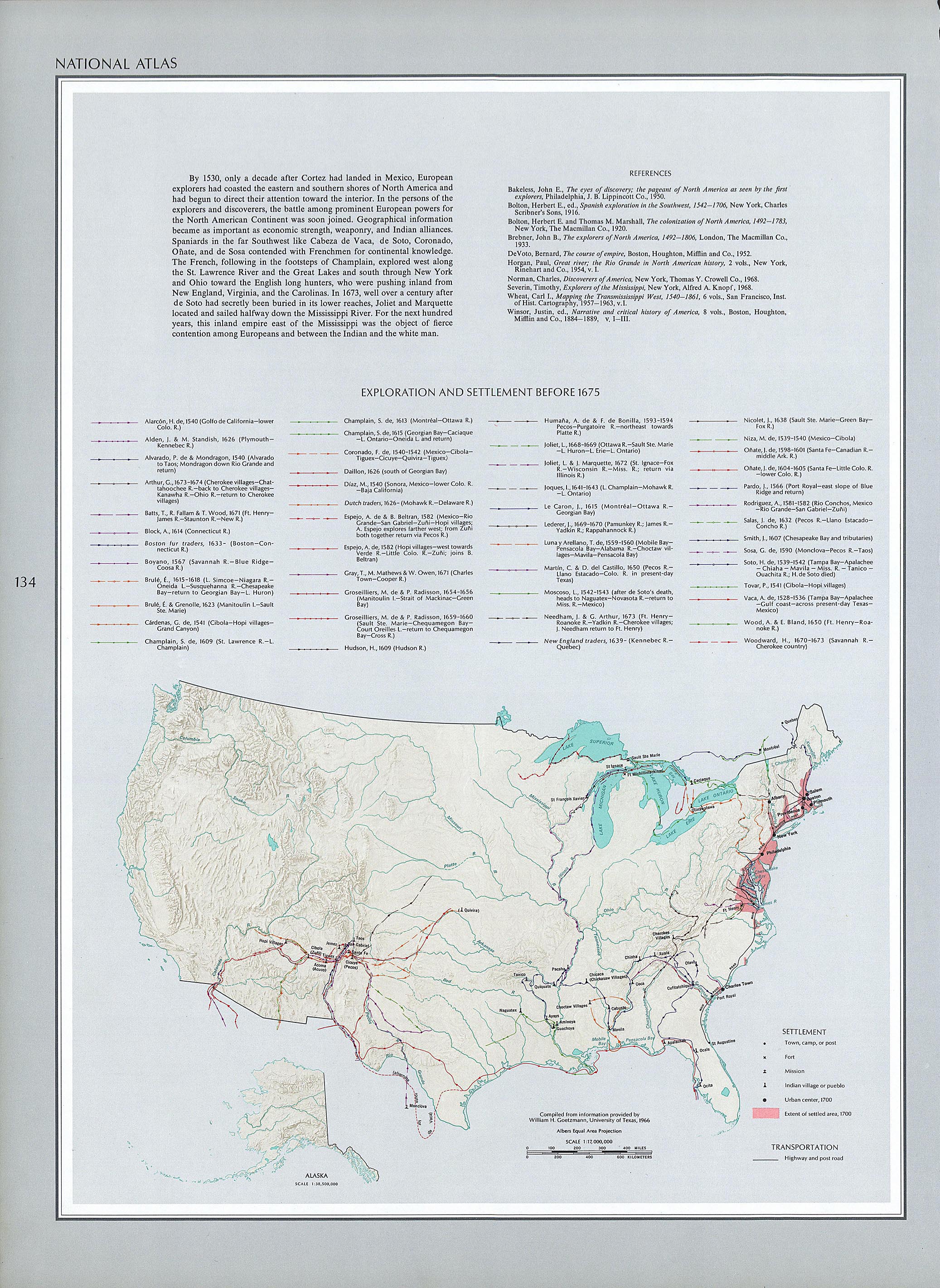
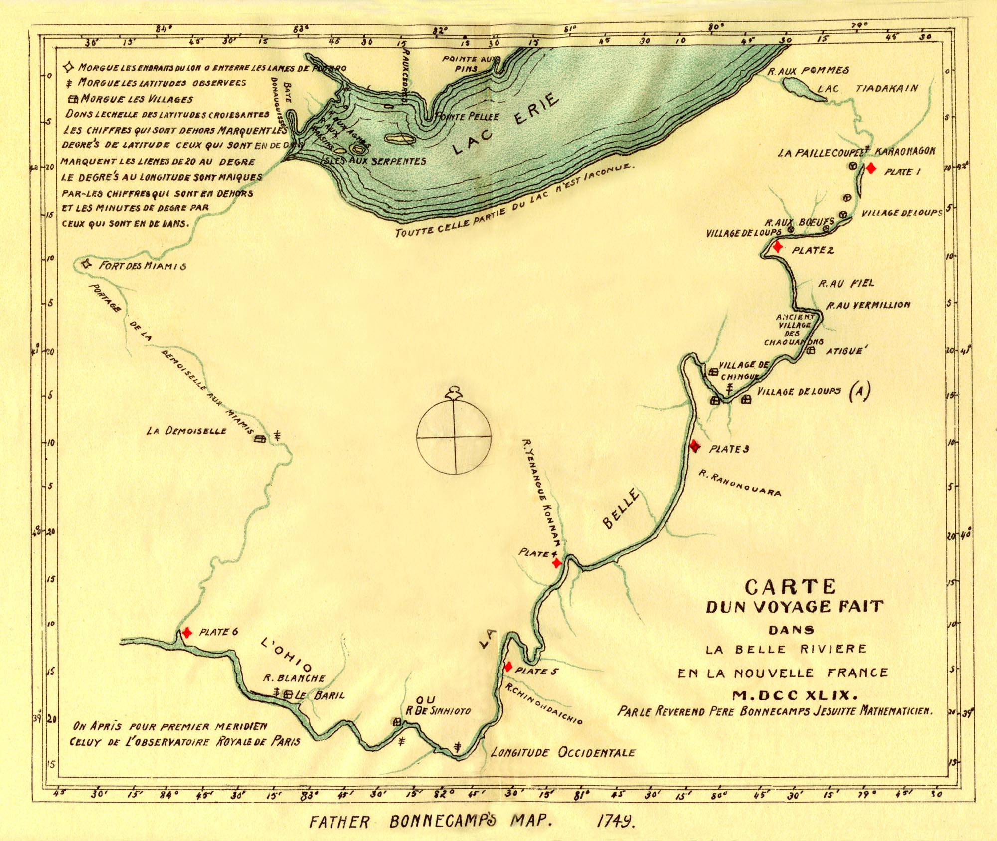
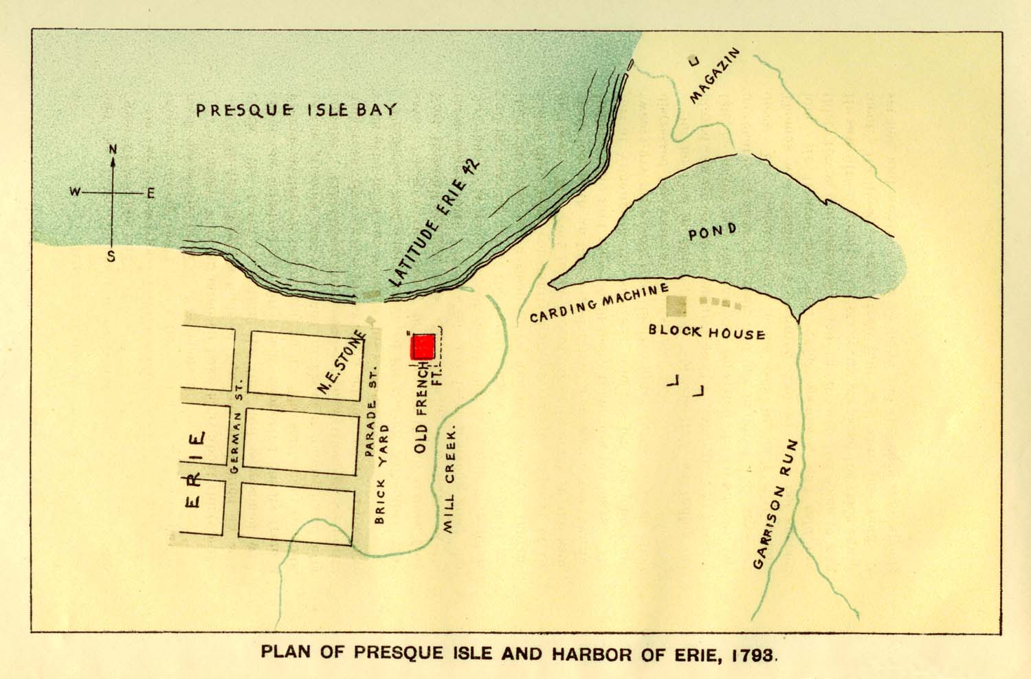
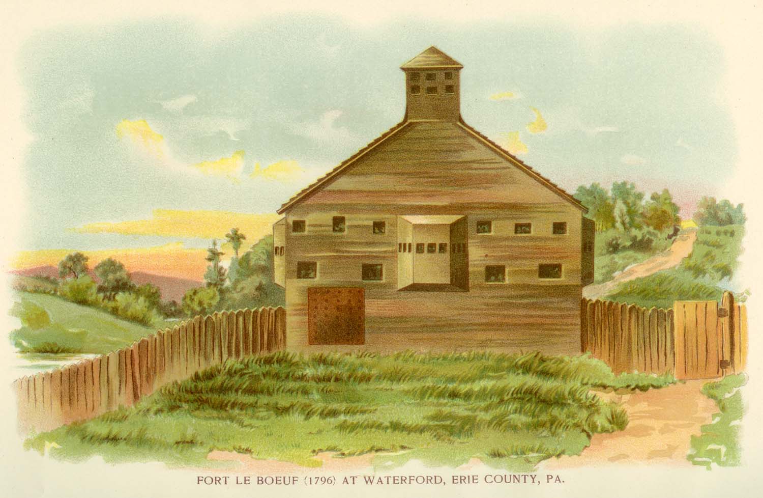
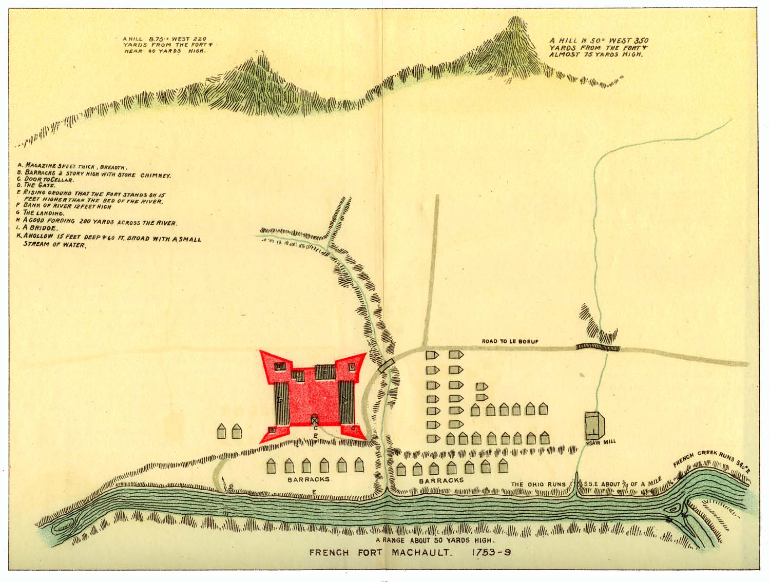
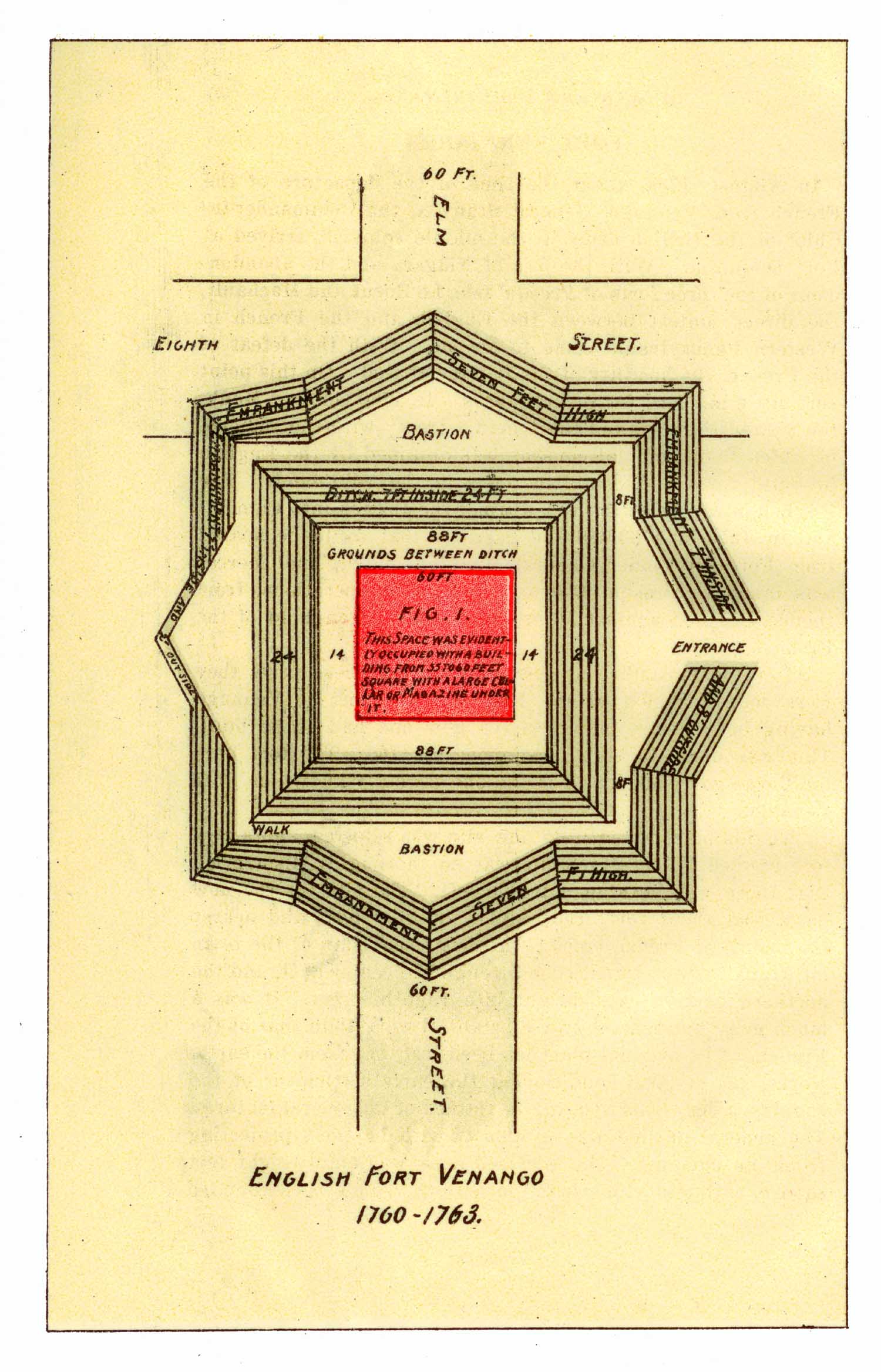
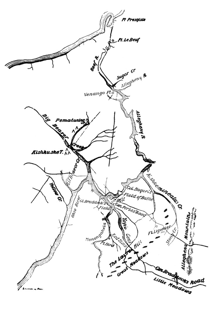

Capture of the French ships Prudent and Bienfaisant
in Louisbourg Harbour, 26 July 1758
Painting attributed to Richard Paton (1717-1791)
The Turning PointBefore July 1758, France Was Winning.After July 1758, England Was Winning. |
| In the summer of 1758 the tide finally began to turn in favour of the British
with the fall of the French fortresses at Louisbourg (Cape Breton Island) and Frontenac (at the headwaters of the St. Lawrence). The Tide Turns Against New France Canadian Military Heritage A Change in Tactics Canadian Military Heritage General Mobilization in Canada (Quebec) Canadian Military Heritage Meagre French Reinforcements, Strong British Effort Canadian Military Heritage |
1758 August 27
French Fort Frontenac captured by British
Nova Scotian Lt. Col. John Bradstreet
of the Royal Americans captures the French Fort Frontenac on Lake
Ontario. Fort Frontenac is the main French supply depot on Lake
Ontario. Bradstreet demonstrates how vulnerable Fort Duquesne's supply
line is, by destroying vast quantities of provisions destined for Forts
Niagara, Detroit and Duquesne, together with the boats that were to
deliver them.
Fall of Fort Frontenac by Military History Encyclopedia
General James Abercromby by Military History Encyclopedia
General James Abercromby Wikipedia
General James Abercromby by Military History Encyclopedia
General James Abercromby Wikipedia
The Forbes Expedition
|
1758 September 4
England begins construction of Fort Ligonier
The Fort at Loyalhanna, Pennsylvania
In 1758, Secretary of State William Pitt and Sir John Ligonier,
Commander-in-Chief of the British Army, organize their strength to drive
the French from the New World by simultaneous attacks on Louisbourg,
Crown Point, Niagura and Duquense. General John Forbes is ordered to
organize and lead a campaign against the French at Fort Duquesne.
British General John Forbes, assigned the task of taking Fort Duquense,
decides to abandon the Braddock route and extend the path westward
through the forests from the recently completed Fort Bedford. A series
of fortifications were built along the "Forbes Road" constructed across
Southern Pennsylvania. The distance to the Forks of the Ohio is too
great for an army to travel without rest and reprovisioning. Almost
exactly half way from Bedford to the Forks, at Loyalhanna Creek [now
Ligonier, Pennsylvania], Forbes decides to build a fortified camp to
serve as the staging area for the final assault on Fort Duquesne. Work
begins on 4 September 1758 on this cap, later to be named Fort Ligonier
in honor of Sir John Ligonier. It is first called the Fort at
Loyalhanna until mid-November 1758, when it first appears in Col.
Bouquet's accounts as Fort Ligonier.
Fort Ligonier by Michael D. McCumber
Fort Ligonier Wikipedia
Battle of Fort Ligonier Wikipedia
Construction of Fort Ligonier by Nat Youngblood
Allegheny Land Trust
Fort Ligonier by Michael D. McCumber
Fort Ligonier Wikipedia
Battle of Fort Ligonier Wikipedia
Construction of Fort Ligonier by Nat Youngblood
Allegheny Land Trust
John Forbes Wikipedia
1758 September 14
Battle of Grant's Hill
By September 1758, the British army under General Forbes is massed at
Fort Ligonier, only fifty kilometres from Fort Duquesne. In keeping
with his methodical strategy, Forbes decides to send a scouting party to
Fort Duquesne. This seemingly sound military decision would lead to a
significant defeat. Major James Grant
of the 77th Highland Regiment was chosen to lead the scouting
expedition. Under his command were 800 men. On September 9, Major
Grant and his little army left the protection of Fort Ligonier and begun
the march west. Five days later, a sortie from the garrison of Fort
Duquesne commanded by de Ligneris surrounds the English, and many of the latter, including Grant, are taken prisoner. 273 English troops are killed, captured, or missing.
Battle of Fort Duquesne (a.k.a. the Battle of Grant's Hill)
Pittsburgh, The Story of a City by Leland Dewitt Baldwin,professor of American history at the University of Pittsburgh
More Canadian Military Heritage
Major Grant's Piper
General James Grant Wikipedia
General James Grant Gazetteer for Scotland
Major General James Grant Northwest Territory Alliance
Grant's Engagement, 9 September 1758 by Nat Youngblood
Allegheny Land Trust
2 October 2008
250th anniversary
|
1758 October 2
Canada's oldest Legislative Assembly first meets
Nova Scotia Provincial Parliament is established – 19 members met on
2 October 1758. For the first hundred years, this Assembly is known as
the Provincial Parliament, and an elected member is called "MPP" –
Member of the Provincial Parliament. Since Confederation in 1867, the
name "Parliament" has been reserved for the federal assembly at Ottawa,
and the Nova Scotia Assembly has been known as the "Legislature", with
an elected member called "MLA"– Member of the Legislative Assembly.
1758 October
Treaty of Easton
The Treaty of Easton was a colonial agreement in North America signed in
October 1758 between the British colonial government of the Province of
Pennsylvania and the Native American tribes in the Ohio Country – the
Native Americans agree not to fight the British during the French and
Indian War.
Treaty of Easton Wikipedia
Gloomy and Dark Days by Daniel K. Richter, The Historical Society of Pennsylvania
Treaty of Easton Wikipedia
Gloomy and Dark Days by Daniel K. Richter, The Historical Society of Pennsylvania
1758 October
The Forbes Road is Nearly Impassible
A trench of half-liquid clay that was called a road
Autumnal rains, uncommonly heavy and persistent, had ruined the
newly-cut road. On the mountains the torrents tore it up, and in the
valleys the wheels of the wagons and cannon churned it into soft mud.
The horses, overworked and underfed, were fast breaking down. The
forest had little food for them, and they were forced to drag their own
oats and corn, as well as supplies for the army, through two hundred
miles of wilderness. In the wretched condition of the road this was no
longer possible. The magazines of provisions formed at Raystown and
Loyalhannon to support the army on its forward march were emptied faster
than they could be filled. Early in October the elements relented; the
clouds broke, the sky was bright again, and the sun shone out in
splendor on mountains radiant in the livery of autumn. A gleam of hope
revisited the heart of Forbes. It was but a flattering illusion. The
sullen clouds returned, and a chill, impenetrable veil of mist and rain
hid the mountains and the trees. Dejected Nature wept and would not be
comforted. Above, below, around, all was trickling, oozing, pattering,
gushing. In the miserable encampments the starved horses stood steaming
in the rain, and the men crouched, disgusted, under their dripping
tents, while the drenched picket-guard in the neighboring forest paced
dolefully through black mire and spongy mosses. The rain turned to
snow; the descending flakes clung to the many-colored foliage, or melted
from sight in the trench of half-liquid clay that was called a road.
The wheels of the wagons sank in it to the hub, and to advance or
retreat was alike impossible.
— This is Francis Parkman's description of the Forbes Road in October 1758, excerpted from a Gutenberg Project e-book: Montcalm and Wolfe
— This is Francis Parkman's description of the Forbes Road in October 1758, excerpted from a Gutenberg Project e-book: Montcalm and Wolfe
Francis Parkman Wikipedia
Francis Parkman by Peter Landry
Francis Parkman by Dictionary of Canadian Biography
Books by Francis Parkman online at Project Gutenberg
Francis Parkman quotes by Wikiquote
Francis Parkman by Peter Landry
Francis Parkman by Dictionary of Canadian Biography
Books by Francis Parkman online at Project Gutenberg
Francis Parkman quotes by Wikiquote
1758 October 12
Battle of Fort Ligonier
The French and Indian army at Loyalhanna was under command of De Vitri.
He began battle almost immediately on their arrival. The firing began
about eleven o'clock in the forenoon and lasted four hours. The battle
was fought on or near the ground where is now the town of Ligonier. The
army at Ligonier numbered twenty-five hundred on its first arrival from
Bedford; but nearly three hundred were lost in Grant's fiasco, leaving
only about twenty-two hundred...
— Volume 1, Chapter 1, Part 2 (Fort Ligonier) History of Westmoreland County, Pennsylvania
Westmoreland County History Project
— Volume 1, Chapter 1, Part 2 (Fort Ligonier) History of Westmoreland County, Pennsylvania
Westmoreland County History Project
Battle of Fort Ligonier Wikipedia
Second-Largest City
Consider the size of the army assembled at Ligonier. By early November
1758, some 4,000 troops were encamped around the fort. This made
Ligonier the second-largest community in Pennsylvania, after
Philadelphia, with its nearly 17,000 people.
— More
— More
1758 October 12
Proclamation issued by Governor of Nova Scotia
invites New Englanders to settle there
Charles Lawrence, Military Governor of Nova Scotia, issued a Proclamation that is published in the Boston Gazette.
It informed the people of New England that since the enemy which had
formerly disturbed and harassed the province was no longer able to do
so, the time had come to people and cultivate, not only the lands made
vacant by the removal of the Acadians, but other parts of "this valuable
province" as well. The Proclamation concluded with the words "I shall
be ready to receive any proposals that may be hereafter made to me for
effectually settling the vacated, or any other lands within the said
province."
More by Peter Landry
More by Peter Landry
This proclamation created a great deal of interest and inquiry, and
finally led to a considerable number of New England farmers settling in
different parts of Nova Scotia, Chignecto getting a good share of
them. The first proclamation had, however, to be supplemented by a second,
in which full liberty of conscience and the right to worship as they
pleased was secured to Protestants of all denominations. This guarantee
was not included in Lawrence's first invitation to the New Englanders,
and the descendants of the Puritans had not read in vain the history of
the sacrifices made by their forefathers to worship in their own way.
Excerpted from:
Chignecto Isthmus: First Settlers by Howard Trueman, 1902
Excerpted from:
Chignecto Isthmus: First Settlers by Howard Trueman, 1902
Charles Lawrence Dictionary of Canadian Biography
Charles Lawrence by Peter Landry
Charles Lawrence Wikipedia
Charles Lawrence by Peter Landry
Charles Lawrence Wikipedia
1758 October 12-13
A French force attacks General Forbes's army at Fort Ligonier and is repulsed. The British continue a slow but determined advance toward Fort Duquesne.
1758 November 24
Fort Duquesne abandoned by French forces
The French abandon and burn Fort Duquesne.
1758 November 25
England takes possession of Fort Duquesne
In one of the most important victories of the whole war, General Forbes
takes possession of the Forks of the Ohio in what turns out to be a
permanent transfer – France never again seriously threatens any part of
the Ohio Country.
French and Indian War: Brigadier General John Forbes' Expedition by James P. Myers, originally published in the December 2001 issue of Military History.
French and Indian War: Brigadier General John Forbes' Expedition by James P. Myers, originally published in the December 2001 issue of Military History.
In honour of William Pitt, the demolished Fort Duquesne is renamed
Pittsburgh by General Forbes. The next day, Forbes writes a letter to
Pitt, dated from "Pittsburgh". The letter reaches Pitt in England in
April 1759, a month after Forbes died.
1758 December
Col. George Washington resigns his commission and retires to Mount Vernon awaiting his January wedding to Martha Dandridge.
1759
First settlers at Chester [now in Lunenburg County, Nova Scotia].
1759 April 18
Five agents from New England arrived at Halifax to take a look at the land promised by Governor Lawrence.
More by Peter Landry
More by Peter Landry
1759 July 24-25
Battle of La Belle Famille
Youngstown, in upper New York state, was the site of one of the
bloodiest and most decisive battles of the French and Indian War. It
ended as a British victory which led to the surrender of Fort Niagara.
Battle of La Belle Famille Wikipedia
Battle of La Belle Famille Wikipedia
1759 July 26
French Fort Niagara surrenders
Fort Niagara was strategically located at the mouth of the Niagara River, where it flows into Lake Ontario.
Final Stage of Conquest by Edward J. Dodson, University of Groningen, Netherlands
Battle of Fort Niagara Wikipedia
Guardhouse of the Great Lakes by the Old Fort Niagara Association
A brief history of Old Fort Niagara by Peter A. Porter
The Western Front Canadian Military Heritage
Final Stage of Conquest by Edward J. Dodson, University of Groningen, Netherlands
Battle of Fort Niagara Wikipedia
Guardhouse of the Great Lakes by the Old Fort Niagara Association
A brief history of Old Fort Niagara by Peter A. Porter
The Western Front Canadian Military Heritage
The treatment of French and Canadian captives taken in the battle of La
Belle Famille and the consequent surrender of Fort Niagara, in
July 1759, reveals the interplay of Amerindian, Canadian, British
colonial, and British military values. The Iroquois negotiated
separately with Sir William Johnson,
the shape-shifting commander of the victors, to keep a number of
prisoners taken in battle and destined for adoption or sacrifice. The
British colonies of New York, New Jersey, and Connecticut initially
received all the other prisoners from the surrendered garrison, and
promptly hired them out to earn their keep. The British Army belatedly
applied what they could of the humane new Anglo-French Convention of
Sluis, calling for very different treatment of prisoners. The results
were bizarre in several respects and, though occurring after years of
bloody frontier war, were surprisingly humane even concerning Canadian
troupes de la marine officers who were notorious for what would now be
called human rights violations...
The treatment of prisoners captured at Niagara in July 1759 evolved through three distinct and revealing phases, beginning immediately after the battle when Sir William Johnson, the Irish-born frontier trader who had become both a Mohawk chief and a British baronet, was in command of the victors... On the morning of 24 July, the arriving Allegheny relief force, led by veteran troupes de la marine Captain François Marie Le Marchand de Ligneris, soon signalled that European martial conventions could not be presumed. A working party of 11 Royal Americans was attacked and most of them were killed and scalped; their corpses were dismembered, and body parts were mounted on stakes positioned to intimidate their living comrades. This occurred after almost all Amerindians on both sides had secretly agreed to withdraw from the action, at least temporarily, and were mere witnesses to a white man's fight. In the main action later that morning, Ligneris's force failed to fight its way through a well-positioned detachment of 500 British and New York regulars at La Belle Famille...
(page 1) When Worlds Collide: The Fate of Canadian and French Prisoners Taken at Fort Niagara, 1759
by Ian K. Steele, Journal of Canadian Studies, Fall 2005
When Worlds Collide: The Fate of Canadian and French Prisoners Taken at Fort Niagara, 1759
by Ian Kenneth Steele, Professor of History at the University of Western Ontario
Journal of Canadian Studies, v39 n3, Fall 2005
...No doubt the vital issue for those fleeing the battlefield was how to become a prisoner. An Iroquois who killed an enemy quickly, and took his scalp, could immediately chase another, but taking a prisoner effectively ended participation in the fight. Did veteran Canadian frontiersmen know the words and gestures that led to successful surrender to Iroquois warriors? Iroquois warriors chasing fleeing Canadians knew that chiefs were more valued than braves...
(page 2) When Worlds Collide: The Fate of Canadian and French Prisoners Taken at Fort Niagara, 1759
Cultural Differences
re
Taking of Captives
...When Virginians, Canadians, and Indians clashed, the Allegheny
borderlands were a new “muddle ground” of fateful cultural confusions
rather than an established middle ground of recognized compromises. The
taking of captives was an early, significant, and portentious part of
the contest. Indians who were resettling the region were familiar with
traditional panis slavery, with raiding for captives in long-range blood
feuds, and with trading Indian captives to Europeans. Their capture of
European traders, as diplomatic gifts, was a very recent development.
Colonial trade rivalries became military, and the paltry forts became
sites of negotiated surrender in 1754. Before European regulars arrived
in numbers, or the Anglo-French war was formally declared, colonial
intruders surrendered to their Indian and colonial rivals on three
occasions. Virginians surrendered their incomplete stockade at the
forks of the Ohio in April. In May, Virginians and Indians ambushed a
Canadian party under Ensign Jumonville, and survivors of the initial
skirmish sought quarter. Within five weeks, avenging Canadians and
Indians forced Virginians to surrender their aptly-named Fort
Necessity. In taking prisoners and hostages in the Allegheny
borderlands, colonial officers adapted and violated both European and
Indian conventions, and took different approaches in dealing with the
independent actions of their Indian allies. On the eve of a major war,
captives and their brethren learned what distinctions had been made, and
that they might well be violated...
— "Hostage-taking 1754: Virginians vs Canadians"
by Ian K. Steele
Journal of the Canadian Historical Association v16 n1 2005 pages 49-73.
Consortium Érudit
— "Hostage-taking 1754: Virginians vs Canadians"
by Ian K. Steele
Journal of the Canadian Historical Association v16 n1 2005 pages 49-73.
Consortium Érudit
26 July 2009
250th anniversary
|
1759 July 26
French Fort Carillon becomes English Fort Ticonderoga
Fort Carillon, on Lake Champlain, is attacked again by the British under the leadership of General Jeffrey Amherst.
After their victory at Fort Carillon early in July 1758, the war had
not gone well for the French. They suffered numerous losses elsewhere
in the war and the small garrison at Fort Carillon was weak. This time,
the British forces took Fort Carillon. Amherst renamed it Fort
Ticonderoga.
More Wikipedia
More by James P. Millard
More by Lee D. and Amberleigh R.
Lake Champlain Canadian Military Heritage
More Wikipedia
More by James P. Millard
More by Lee D. and Amberleigh R.
Lake Champlain Canadian Military Heritage
The spring of 1759 saw the gathering of another British and provincial
army on Lake George with the objective of driving the French from Lake
Champlain. This British expedition was led by a more cautious
commander-in-chief, Major General Jeffery Amherst. The British left
their new fortification of Fort George, located at the southern end of
Lake George, with over 11,000 troops in another impressive flotilla.
Although the French troops at Carillon were nearly equal in number to
the previous year, their rations were short and disease had ravaged the
men inside the fort. The calm, precise, and methodical management of
the British troops and artillery forced the small 400-man French army to
retreat to Crown Point by bateaux and three sloops. The British army
moved most of their fleet overland to Lake Champlain and recovered the
vessels intentionally sunk by the French during their retreat. The
fighting was now concentrated in the Champlain Valley. A small French naval fleet on Lake Champlain hampered the British advance...
— French and British Military Conflict (1664-1763) Lake Champlain Maritime Museum
— French and British Military Conflict (1664-1763) Lake Champlain Maritime Museum
1759 July 31
Battle of Beauport, a French victory
The Battle of Beauport was a prelude, part of the British effort to
deploy soldiers and guns near Quebec in preparation for the Battle of
the Plains of Abraham (which took place six weeks later). An attempt by
the British to land 4,000 men on the north side of the river at the
Montmorency falls east of Beauport on July 31, is supported by a notable
naval bombardment with British ships and batteries firing 4000 rounds
in eight hours on French shoreline entrenchments. The attempt failed;
French General Montcalm inflicted 440 casualties while his forces
suffered only 60.
More Wikipedia
Attack at Montmorency Fails Canadian Military Heritage
More Wikipedia
Attack at Montmorency Fails Canadian Military Heritage
1759 August 4
England takes Crown Point
Crown Point by Gregory T. Furness
Fort Crown Point by New York State Military Museum
Fort Crown Point, when completed and garrisoned, was seven times larger than the French fort (Ste. Frederic) on the same site, and was the largest British fortress in colonial America. Major earthen ramparts faced with logs, ditches and cleared fields of fire covered seven acres and mounted 105 cannons.
1759 September 13
Battle of the Plains of Abraham
The Battle of the Plains of Abraham was a decisive battle of the North
American theatre of the Seven Years' War. It was fought on a plain just
outside the walls of Quebec City in New France (Quebec province).
Combat lasted only half an hour, ending a three-month siege of
Quebec City.
More Wikipedia
Battle of Quebec
Siege of Quebec, 25 June to 18 September 1759
Battle of Plains of Abraham, 13 September 1759
More Wikipedia
Battle of Quebec
Siege of Quebec, 25 June to 18 September 1759
Battle of Plains of Abraham, 13 September 1759
18 September 2009
250th anniversary
|
1759 September 18
Capitulation of Quebec
Wolfe's capture of Quebec.
Articles of Capitulation The Pennsylvania Gazette, 22 November 1759
Battles of 1759-1760 in Quebec National Battlefields Commission
Map Showing the Siege Of Quebec, 5 Sep. 1759
"This map shows in great detail the most important engagement of the French and Indian War, and the largest, the Siege of Quebec in 1759. This proved to be the decisive battle of the War in America, as the fall of Quebec marked the surrender of French control in Canada and the end of her colonial venture in America. This map shows the French and British positions at the outset of the Siege of Quebec on September 5, 1759."
On the morning of that engagement the country from Quebec
to the Mississippi and New Orleans belonged to France.
At sunset she had lost her hold on American power forever.
Chapter XII: History of the Town of Goffstown, New Hampshire
by George P. Hadley, 1922
to the Mississippi and New Orleans belonged to France.
At sunset she had lost her hold on American power forever.
Chapter XII: History of the Town of Goffstown, New Hampshire
by George P. Hadley, 1922
Captain Knox's Account of the Fall of Quebec, 1759 – Dave Stewart
Articles of Capitulation of Quebec 18 Sep 1759
1774 Chapter 83: An Act...Provision for the Government of the Province of Quebec
1790 Chapter 31: An Act...to Repeal Certain Parts...Government of the Province of Quebec
1791 Dec 26: Proclamation...that the Province of Quebec be Divided into Two Distinct Provinces...Upper Canada...Lower Canada
Table of Contents A collection of the acts passed in the Parliament of Great Britain...
1759 October 4
Fort LeBoeuf and Fort Presque Isle abandoned by France
After the capture of Fort Niagara by the British, the French are unable
to supply the garrisons of any of their forts in the Ohio Country. They
abandon and burn Fort LeBoeuf, and Fort Presque Isle.
1759 October 12
D'Olabaratz's Last Stand
The last French Naval activity on Lake Champlain
Early in 1758 the government at Quebec gave Jean d'Olabaratz
the task of ensuring the naval defence of Lake Champlain. Along with
the shipbuilder Pierre Levasseur, son of René-Nicolas Levasseur, he
supervised the building of three xebecs. After they were launched, the Muskelonge, Brochette, and Esturgeon were put under the command of d'Olabaratz, who was himself under François-Charles de Bourlamaque's
orders. His mission consisted of patrolling the waters of Lake
Champlain and delaying as long as possible the advance of the British
troops coming northward from Crown Point. On several occasions he was
on the verge of engaging with enemy ships, but each time he adroitly
evaded them. On 11 October,
Amherst's army started northward on Lake Champlain, intending to attack
the French under François-Charles de Bourlamaque at Île aux Noix...
At daybreak on 12 October 1759 d'Olabaratz and his three xebecs attacked
a troop-laden bateau near the Îles aux Quatre Vents and captured
21 Highlanders of the 42nd Foot. Sailing north, he was spotted later in
the day by a British brigantine and sloop. Captain Joshua Loring
chased him toward the advancing British army, and on 12 October 1759
d'Olabaratz sought refuge in a bay on the western shore of the lake near
present-day Plattsburgh, New York. After holding a council with his
officers on board the Muskelonge, he scuttled his flotilla... [This incident has been attributed erroneously to Joannis-Galand d'Olabaratz, father of Jean d'Olabaratz.]
Jean d'Olabaratz Dictionary of Canadian Biography
Jean d'Olabaratz Dictionary of Canadian Biography
The D'Olobaratz Voyage Re-enactment 2009
The D'Olobaratz Voyage Re-enactment (2-4 October 2009) is two-day
historic seamanship invitational re-enactment commemorationg the
250th anniversary of the last French Naval activity on Lake Champlain.
Led by the replica longboat La Sorciere, a flotilla of replica longboats
manned by Canadian and American re-enactors will retrace the voyage,
with the boats portraying D'Olobaratz's French flotilla racing to reach
Lake Champlain's Crab Island before British re-enactor boats can
intercept them. The longboats will race north from Crown Point, New
York, to Isle la Motte, Vermont, via Basin Harbor, Vermont, and
Cumberland Bay, New York, offering wonderful opportunites for spectators
to cheer their favorite boats ahead...
— The D'Olobaratz Voyage Re-enactment 2009
2009 Vermont Lake Champlain Quadricentennial Commission
— The D'Olobaratz Voyage Re-enactment 2009
2009 Vermont Lake Champlain Quadricentennial Commission
20 November 2009
250th anniversary
|
1759 November 20
Battle of Quiberon Bay
The naval Battle of Quiberon Bay took place on 20 November 1759 during
the Seven Years' War in Quiberon Bay, off the coast of France near
St. Nazaire. British admiral Edward Hawke with 23 ships of the line
caught up with a French fleet with 21 ships of the line under Marshal
de Conflans. The outnumbered Conflans decided to take refuge in the bay
thinking the British would not dare to follow him onto a lee shore.
He was wrong. After hard fighting, most of the French ships were sunk,
captured, or forced aground, thus giving the Royal Navy one of its
greatest victories.
The Battle That Gave Birth to an Empire On November 20th, 1759, the British admiral Sir Edward Hawke won a battle at sea that for its courage and élan was the equal of Trafalgar. Hawke's demolition of a French fleet in Quiberon Bay off the coast of France at St. Nazaire had rewards and consequences for Britain that outshone all that Nelson achieved in the seas off Cadiz...
The Battle of Quiberon Bay Wikipedia
The Battle of Quiberon Bay 1759 by the Royal Navy
The Battle of Quiberon Bay by Military History Encyclopedia
The Battle of Quiberon Bay Musee du Patrimonie Quiberon
20 Nov. 1759: The Battle of Quiberon Bay (painting)
National Maritime Museum, Greenwich, England
21 Nov. 1759: The Day After The Battle of Quiberon Bay (painting)
National Maritime Museum, Greenwich, England
The Battle of Quiberon Bay, on the southwest coast of France, and not
the more celebrated Battle of Quebec, was the decisive military event of
1759. "...in the end, it was Lagos and Quiberon Bay that proved
decisive at Quebec, and control of the Atlantic that settled ownership
of Canada..."
— Fred Anderson, page 383 in his book "Crucible of War: The Seven Years' War and the Fate of Empire in British North America, 1754-1766"
Alfred A. Knopf, New York, 2000
Fred Anderson's Crucible of War review by by Major Robert Bateman, Department of History, United States Military Academy, West Point, New York
In 1759, France had plans to invade Britain but the British fleet, under
Lord Hawke, had been successfully blockading the French west coast,
trapping the French fleet in port. Commodore Duff commanded another
British fleet standing off Quiberon Bay near where it was thought the
troops were being assembled for the invasion. One of France's biggest
warships was the Formidable, an 80-gun ship of the line was commanded by
Chevalier Louis de Saint-Andre du Verger and carrying a complement of
971 persons. The French fleet was kept in port until 14 November 1759
when gales forced Hawke to retreat to Torbay in Devon for refuge and
repairs. The French Commander, Marechal Hubert de Conflans, saw his
opportunity and sailed south for Quiberon ready to attack Duff's ships.
On the 20th, Conflans with 21 ships began the attack on the eight ships
of Duff only to realise that Hawke had returned and was himself
beginning an attack on the French with his fleet of 21 ships. The
French were now both outnumbered and attacked from two sides and were
soon in disarray. A strong wind blew the French into Quiberon Bay and,
eventually 11 ships escaped into the estuary of the River Vilaine and
eight more reached safety in Rochefort. Five French were sunk or burnt
while one, the Formidable, was captured. The Formidable had borne the
brunt of the British attack and suffered badly. It was estimated that
300 men died and over 150 were wounded...
Source: Jean-Francois de Galaup de La Perouse by John Robson
Source: Jean-Francois de Galaup de La Perouse by John Robson
Isle Of Wight Shipwrecks, 'Royal George' (Battle of Quiberon Bay)
BBC's Guide to Life, The Universe and Everything
BBC's Guide to Life, The Universe and Everything
Neither the Anglo-American seizure of Fort Duquesne in 1758 nor the
conquest of Quebec in 1759 proved decisive. What finally determined the
outcome of the war in America were two nearly simultaneous, reinforcing
developments in 1759: the Battle of Quiberon Bay (November 20) and the
Six Nations' decision to abandon the neutral stance it had maintained
since 1755 and join the Anglo-Americans in the Niagara campaign.
The battle cost the French navy its ability to operate on the Atlantic,
denying Levis the reinforcements and supplies he needed to capture
Quebec and resist the invading Anglo-American armies. The absence of
trade goods and weapons simultaneously prevented him from rebuilding the
Indian alliances that Montcalm had destroyed, so that the Iroquois
alliance with the Anglo-Americans tipped the strategic balance
irrevocably against the French...
— Round Table introduction by Fred Anderson
Associate Professor of History, University of Colorado, Boulder, Colorado
The Seven Years' War has been hidden in plain sight for nearly 250 years...
— The Global History of the Seven Years' War
Round Table comments by David Armitage
Associate Professor of History, Columbia University, New York
Frantic graduate students and overcommitted academics may well despair when they begin Fred Anderson's new book, Crucible of War. Length is not the problem, exactly. The trouble is that it is long and utterly readable, compelling, and impervious to skimming. Sadly, serious history books are not supposed to be this much fun nowadays, and readers might experience a bit of guilt for spending the extra time on such a good story...
— Narrative Syle and Indian Actors in the Seven Years' War
Round Table comments by Brian Delay
PhD candidate, Department of History, Harvard University, Boston
The world war that commenced on the banks of the Ohio in 1754 has never been an easy one to name...
— Whose Great War for Empire? British America and the Problem of Imperial Agency
Round Table comments by Eliga H. Gould
Associate Professor of History, University of New Hampshire
...By October 1754, the British plan for operations in North America included an advance on the French forts in the Ohio country, and the destruction of French forts on Lake Ontario, Lake Champlain, and the Nova Scotia isthmus. In early 1755, General Braddock and two regiments of British troops arrived in Virginia. That spring, British ships tried to intercept French reinforcements bound for Canada. In July 1755, Braddock's advance into the Ohio country culminated in the Battle of the Monongahela. This all occurred before an official declaration of war....
— The Spanish Empire and the Seven Years' War
Round Table comments by Paul Mapp
PhD candidate, Department of History, Harvard University, Boston
17591759 proved to be a year of stunning successes for England in North America. One British expedition took Niagara. Another, led by Amherst himself, seized both Ticonderoga and Crown Point, thereby opening the way to Montreal. A third, commanded by young General James Wolfe, sailed up the St. Lawrence River and, after much difficulty, defeated Montcalm on the Plains of Abraham just outside Quebec. The surrender of Quebec itself soon followed. In 1760, Amherst completed the conquest of Canada with a successful three-pronged offensive against Montreal. By the end of 1760, French resistance in North America had virtually ceased. More by Ronald W. McGranahan United States Naval Academy, Annapolis (retired) |
| It was not the British who defeated the French at Quebec; it was
the Six Nations and the British who defeated the French in 1759. If not for the Six Nations, we would now be speaking French, not English. — Letter in the Hamilton Spectator, 27 February 2007 |
| Without the Indians, the French hadn't a hope
of withstanding the British juggernaut... — The Toronto Star, 26 February 2006 |
1760 February 27
Battle of Fort Dobbs
In 1756, Arthur Dobbs, Governor of the Royal Colony of North Carolina,
commissioned the construction of Fort Dobbs to protect Piedmont
settlements during the French and Indian War (1754-1763). At that time,
Fort Dobbs was North Carolina's only frontier fort; all others were on
the Atlantic coast. Only one battle occurred at Fort Dobbs. On
27 February 1760, seventy Cherokee attacked Captain Waddell and his
forty-six men. According to Waddell's account, only two of his men were
wounded, and only one killed; the Cherokee, however, lost ten to twelve
men.
— Fort Dobbs North Carolina History Project
— Fort Dobbs North Carolina History Project
1760
First settlers at Canning [now in Kings County, Nova Scotia].
1760
First settlers at Greenwich [now in Kings County, Nova Scotia].

Greenwich, Nova Scotia, founded in 1760, at the height of the the Seven Years War.
Photographed on 9 November 2005
A Dangerous TimeWe now know that military activity by France in North America after 1760 was ineffectual and of no lasting consequence, but this was not known at the time by people living along the Atlantic coast – modern Nova Scotia and Newfoundland.In 1761 and 1762, these people had no idea that the many hard-fought battles over vast territories in eastern and central North America had ceased. Yes, Louisbourg and Quebec had been taken by England, but the French navy and army, backed by the resources of France (which were much greater than those of England) were still a huge threat, and if France decided to retake its North American territory the place where it would start would be along the Atlantic coast, Newfoundland and Nova Scotia. In 1761 and 1762, people living here were conscious that any day, a large French fleet carrying formidable military forces could suddenly appear over the horizon and launch an invasion. This was only fifteen years since D'Anville had led a fleet of more than 70 ships and 13,000 men over the wide Atlantic to what is now Halifax Harbour. There was no guarantee that what France had done in 1746, France could not do again in the early 1760s. When we see signs announcing that a settlement was established at this time, we should remember that this was a time of great uncertainty about the immediate future. We now know how things turned out, but at the time this was by no means a foregone conclusion. |
1760
Many New England soldiers at Fort Cumberland (Beausejour) and Fort
Lawrence return home after their enlistments expire. Governor Lawrence encourages them to stay and to take up land grants – some do (Troop, Tongue, Huston, others).
1760
Fort Presque Isle taken over by England
England occupies the site of Fort Presque Isle and rebuilds the fortification.
1760
Fort Venango built by England
England occupies the site of Fort Machault and rebuilds the fortification.
British Fort Venango
French Fort Machault
Fort Venango Wikipedia
British Fort Venango
French Fort Machault
Fort Venango Wikipedia
1760 April 28
Battle of Sainte-Foy
After the disaster of the Plains of Abraham on 13 September 1759, the French army
retreats from Quebec to Montreal and regroups under General Levis.
In April 1760, Levis returns to Quebec with an army of over seven
thousand men, including Canadian militia and First Nations warriors. He
hopes to besiege Quebec and force its surrender in the spring, when he
expects a French fleet to arrive. During the battle, the British army
loses over one thousand killed and wounded, and the French almost nine
hundred, making the Battle of Sainte-Foy one of the bloodiest battles on
Canadian soil. However, Levis is unable to retake Quebec City. The
British force remains besieged in the city until naval reinforcements
are able to arrive. The French fleet never arrives – France's navy
having been smashed at Quiberon Bay the previous autumn – and when HMS
Lowestoft raises its flag as it nears Quebec, Levis abandons the siege
and retreats to Montreal, where he surrenders in September 1760 to
overwhelming British force.
More Wikipedia
More Canadian Military Heritage
The Battle of Sainte-Foy Quebec History Encyclopedia
Francois Gaston duc de Levis Quebec History Encyclopedia
More Wikipedia
More Canadian Military Heritage
The Battle of Sainte-Foy Quebec History Encyclopedia
Francois Gaston duc de Levis Quebec History Encyclopedia
1760 May
The Final Seige of Quebec
British Fleet Lifts the Siege Canadian Military Heritage
1760 July 8
The Battle of the Restigouche
The last naval engagement of the Seven Years War
This battle — the last naval engagement of the Seven Years War between
France and Great Britain for possession of North America — was not
fought on the open sea, but rather on the shallow waters of the
Restigouche River, between what is now Quebec and New Brunswick. This
was the last battle between the French and British for the control of
the New World. It sealed forever the fate of New France.
GPS location: 48°01'N 66°39'W
Google map showing this location
Google map showing this location
Battle of Restigouche Canadian Encyclopedia
Battle of the Restigouche Industry Canada archive
Battle of the Restigouche National Historic Site (1) Parks Canada
Battle of the Restigouche National Historic Site (2) Parks Canada
Battle of the Ristigouche Municipality of Restigouche South East
John Byron Dictionary of Canadian Biography
Byron was the British commander during the Battle of the Restigouche
1760 August 16-24
Battle of the Thousand Islands
The Battle of the Thousand Islands was fought 16-24 August 1760, in the
upper St. Lawrence River, along the present-day US-Canada border, by
British and French forces during the closing phases of the French and
Indian War. The engagement took place at Fort Levis (about one mile
upstream from the present Ogdensburg-Prescott International Bridge),
Point au Baril (now Maitland, Ontario), and the surrounding waters and
islands. The small French garrison at Fort Levis held the much larger
British army at bay for over a week, managing to sink two British
warships and to cripple a third. Their resistance delayed the British
advance to Montreal from the west...
Battle of the Thousand Islands Wikipedia
Fort Levis by New York State Military Museum
Fort La Presentation by New York State Military Museum
Battle of the Thousand Islands Wikipedia
Fort Levis by New York State Military Museum
Fort La Presentation by New York State Military Museum
1760 September 5
Peace treaty between the Huron and the British

National Post, 5 September 2007
A treaty of peace was concluded in September 1760 whereby the Huron came
under British protection. They were granted much more than a safe
conduct. They were received on the same terms as the Canadian
militiamen; that is, there would be no punishment for having taken up
arms against the British. Furthermore, they were accorded the free
exercise of their religion, of their customs and of freedom of trade
with the English. In the context of the time, the free exercise of
their customs referred to noninterference by Europeans in their
lifestyle, local government and justice system. There would be no
imposition of laws, taxation or military service... The terms of the
treaty were respected during the early years of British rule. In time
the provincial and federal governments again infringed on the Huron's
rights, until in May 1990 the Supreme Court of Canada took notice of the
treaty.
— Murray Treaty of Longueil, 1760 Canadian Encyclopedia
— Murray Treaty of Longueil, 1760 Canadian Encyclopedia
Supreme Court of Canada, October 1989
Huron band Indians charged with cutting down trees, camping and making fires in places not designated in Jacques-Cartier park contrary to provincial regulations — Whether regulations applicable to Hurons practising customs and religious rites — Whether document signed by General Murray in 1760 guaranteeing them free exercise of their customs and religion is a treaty — Whether treaty still in effect — Whether territorial scope of treaty extends to territory of park so as to make regulations unenforceable in respect of accused... The Quebec Superior Court held that the document was not a treaty and dismissed the appeal. A majority of the Quebec Court of Appeal reversed this judgment. The court found that the 1760 document was a treaty and that the customary activities or religious rites practised by the Hurons in Jacques-Cartier park were protected by the treaty. Section 88 of the Indian Act made the respondents immune from any prosecution. This appeal is to determine (1) whether the 1760 document is a treaty; (2) whether it is still in effect...
Decision:– The treaty was still in effect when the offences with which the respondents were charged were committed. The Act of Capitulation of Montreal in 1760 and the Treaty of Paris in 1763 did not have the effect of terminating rights resulting from the treaty...
— R. v. Sioui [1990] Supreme Court of Canada Human & Constitutional Rights
Arthur W. Diamond Law Library at Columbia Law School, New York
The Murray Treaty, made in September 1760 during the final week of
conflict between the French and the British, was in the form of a
laissez-passer which guaranteed the Hurons safe passage to their village
at Lorette, near Quebec. The document preserved the Hurons' right to
trade with the British as well as their customary practices and Catholic
religion. The military governor of Quebec, James Murray,
signed the treaty on behalf of the Crown. It was confirmed as a treaty
by the Supreme Court of Canada in the case of R. v. Sioui in 1990.
— Backgrounder Historic Indian Treaties
Department of Indian and Northern Affairs, Government of Canada
— Backgrounder Historic Indian Treaties
Department of Indian and Northern Affairs, Government of Canada
Supreme Court of Canada - Decisions - R. v. Sioui
This appeal is to determine (1) whether the 1760 document is a treaty...
Although during the siege of Quebec James Murray was the fourth ranking officer in the British military hierarchy in Canada, after the death of Wolfe and the departure of Townshend and Monckton he became the highest ranking officer in the British Army stationed in Canada. General Amherst was the highest military authority in North America and his authority covered all British soldiers in Canada. Murray received the command of the troops at Quebec from him. A very important fact is that since 1759 Murray had also acted as military governor of the Quebec district, which included Lorette. He had used his powers to regulate, inter alia, the currency exchange rate and the prices of grain, bread and meat and to create civil courts and appoint judges... The respondents are correct in stating that on September 5, 1760, Murray was the highest ranking British officer with whom the Hurons could have conferred... The treaty was still in effect when the offences with which the respondents were charged were committed. The Act of Capitulation of Montreal in 1760 and the Treaty of Paris in 1763 did not have the effect of terminating rights resulting from the treaty...
— R. v. Sioui, [1990] 1 S.C.R. 1025 Judgments of the Supreme Court of Canada
8 September 2010
250th anniversary
|
1760 September 8
French Montreal is captured by English forces
Half of the North American continent changes hands
Surrounded on all sides by superior forces, French Governor Vaudreuil surrenders Montreal and all of New France to the English under the command of General Jeffrey Amherst. General Levis, after burning his flags, reluctantly agrees to lay down his army's weapons. The French soldiers are paroled back to France.
More Seven Years War Association
More Seven Years War Association
1760 October
In North America, the fighting ends
Although the Seven Years War (the French and Indian War) does not
officially end until 1763, in North America the fighting pretty much
comes to an end after British General Jeffrey Amherst captures French
Montreal in September 1760. England and France continue the war in
Europe and India, but military activity by France in North America after
1760 is sporadic and of little consequence.
1760 October 9
Charles Lawrence, Military Governor of Nova Scotia, dies suddenly at Halifax
1760 October 25
King George II dies. George III becomes King of England.
The old King George II, who died on the 25th of October, 1760, was succeeded on the throne of England by his grandson, George III,
aged twenty-two, the first really native sovereign who had been called
to reign over England since the last of the Stuarts in 1714. George I
and George II were Germans, in their feelings and their manners as well
as their language. The young George III had been raised in England,
and was completely English.
1761
Fort Ouiatenon is captured by England
Fort Ouiatenon (the first fortified European settlement in what is now
Indiana) is built by France in 1717 to prevent the British from
expanding to the Ohio and Wabash County. At its height in the 1730s and
1740s, the population of the settlement around the fort is 2000 to 3000
people. In 1761, England captures Fort Ouiatenon. It is never
regarrisoned. In 1791, President George Washington orders the fort to
be burned. Its location is forgotten for more than a century.
Fort Ouiatenon Wikipedia
Fort Ouiatenon history by Tippecanoe County Historical Association
Fort Ouiatenon (2) by Tippecanoe County Historical Association
Fort Ouiatenon... Archaeological investigations of the fort...
Fort Ouiatenon historical park by Tippecanoe County
Fort Ouiatenon by Tippecanoe Ancient Fife and Drum Corps
1762 January
England declares war on Spain
Before 1762 ended, Cuba was in the hands of the English, the Philippines
were ravaged and galleons laden with Spanish gold were captured by
British ships...
— Chapter LIV (54): Louis XV, The Seven Years War
A Popular History of France From The Earliest Times, Volume VI c.1830
by Francois Pierre Guillaume Guizot
Project Gutenburg
— Chapter LIV (54): Louis XV, The Seven Years War
A Popular History of France From The Earliest Times, Volume VI c.1830
by Francois Pierre Guillaume Guizot
Project Gutenburg
1762
France invades Newfoundland
In Newfoundland in 1762, St. John's, Carbonear, and Trinity are captured by a French squadron under Admiral de Ternay. They are re-captured in September 1762 by Colonel Amherst, brother of Sir Geoffrey Amherst, Capt. McDonel, with Highlanders and Provincials (Loyal Americans) Light Infantry. Battle of Quidi Vidi.
— Chapter XXIII (23): Chronology
Page 652, History of Newfoundland by Judge D.W. Prowse
St. John's, Carbonear, and Trinity are captured by a French squadron under Admiral de Ternay...
— Chapter XXIII (23): Chronology
Page 652, History of Newfoundland by Judge D.W. Prowse
St. John's, Carbonear, and Trinity are captured by a French squadron under Admiral de Ternay...
Charles-Henri-Louis d'Arsac de Ternay Dictionary of Canadian Biography
Charles de Ternay Wikipedia (in French)
Charles de Ternay Wikipedia (in French)
Quidi Vidi played an important role in the battle of the French and
English over Newfoundland, and was considered to be one of four of the
most important places on the Avalon Peninsula. In 1762, the French —
having captured St. John's — built two gun batteries at Quidi Vidi to
defend Signal Hill from rear attack. When the British regained control
of the area in September 1762, they reinforced Quidi Vidi, building a
garrison and cutting a road from Fort William to the hills of the
village...
— Quidi Village Development Plan
by St. John's City Planning Department (undated, probably 2005)
http://www.stjohns.ca/cityservices/planning/pdfs/QuidiVidiDraftPlan.pdf
— Quidi Village Development Plan
by St. John's City Planning Department (undated, probably 2005)
http://www.stjohns.ca/cityservices/planning/pdfs/QuidiVidiDraftPlan.pdf
The French expedition to Newfoundland, which was organized in complete
secrecy (only Ternay knew its true destination), assembled 750 soldiers —
including 161 Irishmen as the nucleus of a battalion to be recruited
from the Irish fishermen in Newfoundland. Transport consisted of
two ships of the line, a frigate, and two flutes. They set sail from
Brest on 8 May 1762. On 23 June, hoisting the British flag in order to
avoid giving alarm, the five ships anchored at Bay Bulls, 20 miles south
of St. John's. The next day the infantry, under Colonel
Joseph-Louis-Bernard de Cleron d'Haussonville, landed without opposition
and immediately set off for St. John's. The garrison there was weak,
and on 27 June 1762 the French captured Fort William Henry. Ternay and
his sailors undertook a systematic destruction of the British
establishments: all the fisheries were destroyed, and 460 ships of all
sizes were captured or sunk. It is estimated that the British suffered
more than £1,000,000 in damages.
— Charles-Henri-Louis d'Arsac de Ternay Dictionary of Canadian Biography
— Charles-Henri-Louis d'Arsac de Ternay Dictionary of Canadian Biography
1762 June 27
St. John's Captured by France
On 27 June 1762, Fort William Henry (St. John's, Newfoundland) is captured by French soldiers.
In July 1762, word reached Halifax that St. John's, Newfoundland, had
fallen to the French. The British sailed from Halifax in August,
reinforced with ships and troops from New York, and retook the island
city...
— "Cook's Tour" by John Boileau, Halifax Chronicle-Herald, 27 October 2002
— "Cook's Tour" by John Boileau, Halifax Chronicle-Herald, 27 October 2002
1762 September 15-18
The Battle of Signal Hill
The final battle in North America of the Seven Years War
The last military clash ever, between British and French forces in North
America, is fought in 1762 at the Battle of Signal Hill in
Newfoundland. On 15 September, in an action known as the Battle of
Signal Hill, British troops under the command of Lieutenant Colonel
William Amherst rout the French on Signal Hill and drive them down into
Fort William. On the 17th, the British open fire on the fort from the
higher ground of Signal Hill, and the French surrender the next day.
Battle of Signal Hill Wikipedia
Signal Hill, Newfoundland Wikipedia
Bataille de Signal Hill Wikipedia (in French)
Battle of Signal Hill Wikipedia
Signal Hill, Newfoundland Wikipedia
Bataille de Signal Hill Wikipedia (in French)
The Recapture of St. John's, Newfoundland, in 1762
As described in the journal of Lieut.-Colonel William Amherst, commander of the British expeditionary force
Newfoundland's Grand Banks Site
As described in the journal of Lieut.-Colonel William Amherst, commander of the British expeditionary force
Newfoundland's Grand Banks Site
10 February 2013
250th anniversary
|
1763 February 10
Final Treaty of Paris is signed
Britain acquires Quebec, Florida, Minorca and large additional parts of
India and the West Indies. France keeps the islands of St. Pierre and
Miquelon.
After the Seven Years War was over, Britain controlled all of North America east of the Mississippi River.
Treaty of Paris 1763 Wikipedia
Treaty of Paris (complete text) Wikisource
Treaty of Paris 1763 the Avalon Project, Yale Law School
Treaty of Paris 1763 Canadian Encyclopedia
Treaty of Paris (complete text) Ohio History Central
Treaty of Paris 1763 Department of Humanities Computing
University of Groningen, Netherlands
7 October 2013
250th anniversary
|
1763 October 7
Royal Proclamation of 1763
This document has been called the "Magna Carta of Indian Rights" and
recently has been held by the courts to have "the force of a statute
which has never been repealed". It was issued after the Treaty of Paris
ended the Seven Years War and was intended to organize the governments
of Britain's new acquisitions on the mainland of North America.
Royal Proclamation of 1763 by Bill Henderson
Royal Proclamation of 1763 Wikipedia
Royal Proclamation of 1763 Canadian Encyclopedia
Royal Proclamation of 1763 by Marjie Bloy
Royal Proclamation of 1763 by Bill Henderson
Royal Proclamation of 1763 Wikipedia
Royal Proclamation of 1763 Canadian Encyclopedia
Royal Proclamation of 1763 by Marjie Bloy

Eastern North America at the end of the Seven Years War: showing the
British Province of Quebec, the British thirteen colonies on the
Atlantic coast and the Indian Reserve (as of the Royal Proclamation of
1763).
Source: http://en.wikipedia.org/wiki/Image:Map_of_territorial_growth_1775.jpg
Source: http://en.wikipedia.org/wiki/Image:Map_of_territorial_growth_1775.jpg
Note that the area labelled "Province of Quebec" bears little
resemblance to the modern Province of Quebec (for which the map shows
only a narrow band along the north shore of the St. Lawrence River).
The area here labelled "Province of Quebec" includes what is now
southern Ontario, Ohio, Indiana, Illinois, Michigan, Wisconsin and
Minnesota. The boundary between Nova Scotia (now New Brunswick) and
Northern Massachusetts (now Maine) is located along the eastern section
of the modern boundary between Canada and the United States, except that
Nova Scotia and Northern Massachusetts both extend northward to the
St. Lawrence River. Of course, at that time there was no United States
of America, and the modern boundary between Canada and the U.S.A., that
wholly shapes our modern understanding of this geography, did not then
exist.
Timeline Ends |
Postscripts
With the indifference and lack of union among the English colonies
during the 1720s to 1750s, compared to the united direction and resolve
on the part of the French added to their better geographical position
from a military point of view, how could the French lose?
What could possibly go wrong?
There were two main reasons for the ultimate French loss of North America: concentration and sea-power. In the final phase of this great struggle, France selected Europe for her greatest effort, while Britain selected America. But even if France had devoted more attention and resources to Canada, she would have failed because of her inferiority to Britain on the ocean. The degree to which Britain had outstripped France in this respect may be judged by the fact that in 1755 the British navy contained 132 ships-of-the-line and the French 31.
Thus, with the entrance of the mother countries into their American colonies' quarrels, we must revise our sketch-map of the military situation. Both French Canada and the English colonies were so weak compared with France and Britain, that the effective striking-power shifts its origin to the other side of the ocean. The question became: Which country could send the strongest force across the Atlantic? Edmund Burke gave the answer: "France was obliged to sit, the impotent spectator of the ruin of her colonies, without being able to send them the slightest succour. It was then that she found what is was to be inferior at sea." The Atlantic Ocean joined the English colonies to Britain; it isolated Canada from France...
— Excerpted and adapted from A History of Canada (page 152)
by James Bingay, published 1934 by Thomas Nelson and Sons, Toronto
The French and Indian War (known as the Seven Years War in Europe) would
change everything, as England, France, and dozens of American Indian
nations fought for control of North America west of the Appalachian
Mountains, and the confluence of three mighty rivers at Pittsburgh –
Allegheny, Monongahelia, and Ohio – were seen as the strategic key to
victory. By war's end, France virtually had been ousted from the
continent; the British empire at last ringed the globe; and American
Indians faced the difficult task of defending their independence against
a robust Anglo-American opponent...
— The war that started a revolution USA Today magazine, published in New York by the Society for the Advancement of Education, May 2005
— The war that started a revolution USA Today magazine, published in New York by the Society for the Advancement of Education, May 2005
Looking back at a project that turned out very differently from the one
that I had planned, the degree to which historical narratives are
bounded not only by time and argument but by the author's implicit point
of view has also become uncomfortably apparent. From the outset I knew
that my subject was not the Seven Years' War and its impacts as a
whole, but the war and its influence on the Anglo-American political
community in relation to the Indian peoples with whom the
Anglo-Americans dealt. I therefore always knew, at some level, that
I could never treat French and Canadian topics (much less the German,
Austrian, Spanish, and subcontinental Indian elements of the larger
story) as fully as British and American ones...
— The Seven Years' War: A provincial's view by Fred Anderson
Canadian Journal of History, December 2000
— The Seven Years' War: A provincial's view by Fred Anderson
Canadian Journal of History, December 2000
No "defining moment" has acted as a catalyst to Canadian historians
because of the continuance of two nationalisms (called the "two
solitudes"): that of anglophone Canada and that of Quebec. Canadian
historians have tended to deconstruct Canada by specializing in discrete
local or provincial studies...
— Historians as Nationalists reviewed by Hubert C. Johnson
Canadian Journal of History, December 2005
— Historians as Nationalists reviewed by Hubert C. Johnson
Canadian Journal of History, December 2005
To explain why France failed in its bid to dominate the New World,
Kenneth Banks examines the crucial role played by communications...
While the absolutist state was relatively successful in monopolizing
communications in France, Banks argues that it faced major difficulties
in obtaining, analyzing, and controlling information in the colonies in
order to shape the social order and maintain metropolitan authority...
Chapter six examines the state's dependance on transatlantic merchant
networks to carry dispatches and to keep informed... Chapter seven
suggests that colonies' governing elites furnished reliable information
only in return for promotions and honours: governors and intendants
distributed patronage to keep information flowing...
— Chasing Empire Across the Sea: Communications and the State in the French Atlantic, 1713-1763 reviewed by William S. Cormack
Canadian Journal of History, August 2004
— Chasing Empire Across the Sea: Communications and the State in the French Atlantic, 1713-1763 reviewed by William S. Cormack
Canadian Journal of History, August 2004
...On the 10th of February, 1763, the peace concluded between France,
Spain, and England completed without hope of recovery the loss of all
the French possessions in America. Louisiana had taken no part in the
war; it was not conquered; France ceded it to Spain in exchange for
Florida, which was abandoned to the English. Canada (Quebec) and all
the islands of the St. Lawrence shared the same fate. Only the little
islands of St. Pierre and Miquelon were preserved for the French
fisheries. One single stipulation guaranteed to the Canadians the free
exercise of the Catholic religion... The weak hands of King Louis XV
and of his government had let slip the fairest colonies of France.
Canada and Louisiana had ceased to belong to her; yet attachment to
France subsisted there a long while, and her influence left numerous
traces there.
— Chapter LIII (53): Louis XV, France in the Colonies, 1745-1763
A Popular History of France From The Earliest Times, Volume VI c.1830
by Francois Pierre Guillaume Guizot Project Gutenburg
— Chapter LIII (53): Louis XV, France in the Colonies, 1745-1763
A Popular History of France From The Earliest Times, Volume VI c.1830
by Francois Pierre Guillaume Guizot Project Gutenburg
Is The Seven Years War Important?...From western Pennsylvania, the war spread far and wide –to upstate New York, to the gates of Montreal and Quebec, to Nova Scotia, the Caribbean, Calcutta, India; Manila, the Philippines; West Africa; and across Europe... In 1763, the war formally ended with the Treaty of Paris. The French, humbled in battle, held on to Louisiana in North America. The rest belonged to the Spanish, who took possession of the lands west of the Mississippi, and to Britain, which now counted Catholic Canada among its possessions. Robert Messner, of the Braddock's Field Historical Society, said that because Britain, and not France, proved victorious, is why "we speak English and not French. As a lawyer, I think it's also significant that we practice English common law, not French law. Those are two extraordinary outcomes"... More Pittsburgh Tribune-Review (newspaper), 16 May 2004 |
Map Showing British Colonies in North America 1763-1775
University of Texas
1763: A New Map of North America, from the Latest Discoveries
University of Georgia
1774: A Map of North America, as Divided amongst the European Powers
University of Georgia
Reference Map:
A new and accurate map of the English empire in North America; Representing their rightful claim as confirmed by charters and the formal surrender of their Indian friends; likewise the encroachments of the French, with the several forts they have unjustly erected therein
London, 1755
Maps in margin: A plan of the harbor and town of Louisbourg on the isle of Cape Briton.
— A plan of Chebucto Harbor.
— The Atlantic Ocean.
— Fort Frederick built by the French at Crown or Scalp Point in the year 1731.
— A plan of Port Dauphin on the isle of Cape Briton.
— A plan of the harbour of Annopolis Royal. ("Annopolis" is the map's spelling)
— A plan of the town of Quebeck.
André Doreil's
role as commissary of wars was roughly that of a deputy
quartermaster-general in charge of the care and maintenance of all the
French regular troops in Canada, attending to their billeting,
equipment, clothing, rations, and hospital care... Doreil's letters show
genuine concern for his men. They are filled with details concerning
the soldiers' billeting – often with the habitants (local residents) –
their pay (he is not at all happy with paper money and the resultant
loss in exchange for the troops), their clothing (they require more and
better quality shoes), their rations (including a ration of wine for
those in hospital). He set up field hospitals for the first time,
harassed the minister for more, and better, surgeons and surgical
instruments, and carried on a running feud with the financial commissary
and commissary of wars at Louisbourg, Jacques Prevost de La Croix,
whose apparent indifference to the needs of the regular battalions
stationed there was a constant worry to Doreil... Perhaps the real value
of Doreil's correspondence is its depiction of the dark side of 18th
century warfare, the squalor, misery, and appalling death rates from
disease in contrast to the fife and drum of battle...
General reference:
The French and Indian War (1754-1763)
Exerpted from The American Colonial Wars: A Concise History 1607-1775, by Nathaniel Hale
Republished by the New Jersey Frontier Guard, 1996
The French and Indian War (1754-1763)
Exerpted from The American Colonial Wars: A Concise History 1607-1775, by Nathaniel Hale
Republished by the New Jersey Frontier Guard, 1996
The War That Made America
Four-hour TV Special Series
The War That Made America
tells the remarkable stories of The French and Indian War. As the
French and English clashed to control North America, Native Americans
manipulated the balance of power. It also marks the inauspicious
beginning of George Washington's military career.
Broadcast on PBS Boston WGBH
2006 January 18 — 9:00-11:00pm EST (Episodes 1 & 2)
2006 January 25 — 9:00-11:00pm EST (Episodes 3 & 4)
2006 January 18 — 9:00-11:00pm EST (Episodes 1 & 2)
2006 January 25 — 9:00-11:00pm EST (Episodes 3 & 4)
Episode 1: A Country Between
Episode 2: Unlikely Allies
Episode 3: Turning the Tide
Episode 4: Unintended Consequences
Episode 2: Unlikely Allies
Episode 3: Turning the Tide
Episode 4: Unintended Consequences
2007 February 01, 08, 15, 22 — 8:00pm EST
2007 February 04, 11, 18, 25 — 2:00am, 3:30pm, 11:00pm EST
2007 February 05, 12, 19, 26 — 2:30am EST
(The 2007 reruns were one episode on each of four weekends.)
References
The French and Indian War Without the French: Fred Anderson's Crucible of War
...To understand it, we must first chart the paths by which the interests of the Iroquois Confederacy, the government of New France, the governor of Virginia, and a group of Anglo-American land speculators all converged, in the spring of 1754, at the spot where the Allegheny joins the Monongahela and the Ohio's waters begin their long descent through the heart of America to the Mississippi, and the sea...
...To understand it, we must first chart the paths by which the interests of the Iroquois Confederacy, the government of New France, the governor of Virginia, and a group of Anglo-American land speculators all converged, in the spring of 1754, at the spot where the Allegheny joins the Monongahela and the Ohio's waters begin their long descent through the heart of America to the Mississippi, and the sea...
Empires at War: The French and Indian War and the Struggle for North America, 1754-1763
...Empires at War captures the sweeping panorama of this first world war, especially in its descriptions of the strategy and intensity of the engagements in North America, many of them epic struggles between armies in the wilderness. William M. Fowler Jr. views the conflict both from British prime minister William Pitt's perspective – as a vast chessboard, on which William Shirley's campaign in North America and the fortunes of Frederick the Great of Prussia were connected – and from that of field commanders on the ground in America and Canada, who contended with disease, brutal weather, and scant supplies, frequently having to build the very roads they marched on. As in any conflict, individuals and events stand out: Sir William Johnson, a baronet and a major general of the British forces, who sometimes painted his face and dressed like a warrior when he fought beside his Indian allies; Edward Braddock's doomed march across Pennsylvania; the valiant French defense of Fort Ticonderoga; and the legendary battle for Quebec...
...Empires at War captures the sweeping panorama of this first world war, especially in its descriptions of the strategy and intensity of the engagements in North America, many of them epic struggles between armies in the wilderness. William M. Fowler Jr. views the conflict both from British prime minister William Pitt's perspective – as a vast chessboard, on which William Shirley's campaign in North America and the fortunes of Frederick the Great of Prussia were connected – and from that of field commanders on the ground in America and Canada, who contended with disease, brutal weather, and scant supplies, frequently having to build the very roads they marched on. As in any conflict, individuals and events stand out: Sir William Johnson, a baronet and a major general of the British forces, who sometimes painted his face and dressed like a warrior when he fought beside his Indian allies; Edward Braddock's doomed march across Pennsylvania; the valiant French defense of Fort Ticonderoga; and the legendary battle for Quebec...
French & Indian War/Seven Years' War, 1754-63
...The French and Indian War was the North American conflict that was part of a larger imperial conflict between Great Britain and France known as the Seven Years' War. The French and Indian War began in 1754 and ended with the Treaty of Paris in 1763. The war provided Great Britain enormous territorial gains in North America, but disputes over subsequent frontier policy and paying the war's expenses led to colonial discontent, and ultimately to the American revolution. The French and Indian War resulted from ongoing frontier tensions in North America as both French and British imperial officials and colonists sought to extend each country's sphere of influence in frontier regions... In 1753, prior to the outbreak of hostilities, Great Britain controlled the thirteen colonies up to the Appalachian Mountains, but beyond lay New France, a very large, sparsely settled colony that stretched from Louisiana through the Mississippi Valley and Great Lakes to Canada... The border between French and British possessions was not well defined, and one disputed territory was the upper Ohio River valley...
...The French and Indian War was the North American conflict that was part of a larger imperial conflict between Great Britain and France known as the Seven Years' War. The French and Indian War began in 1754 and ended with the Treaty of Paris in 1763. The war provided Great Britain enormous territorial gains in North America, but disputes over subsequent frontier policy and paying the war's expenses led to colonial discontent, and ultimately to the American revolution. The French and Indian War resulted from ongoing frontier tensions in North America as both French and British imperial officials and colonists sought to extend each country's sphere of influence in frontier regions... In 1753, prior to the outbreak of hostilities, Great Britain controlled the thirteen colonies up to the Appalachian Mountains, but beyond lay New France, a very large, sparsely settled colony that stretched from Louisiana through the Mississippi Valley and Great Lakes to Canada... The border between French and British possessions was not well defined, and one disputed territory was the upper Ohio River valley...
The French & Indian War: Deciding the Fate of North America
...In the summer of 1754, deep in the wilderness of western Pennsylvania, a very young George Washington suffered his first military defeat, and a centuries-old feud between Great Britain and France was rekindled. The war that followed would decide the fate of the entire North American continent – not just between Great Britain and France, but for the Spanish and Native Americans as well. Fought across virgin wilderness, from Nova Scotia to the forks of the Ohio River, the French and Indian War is best remembered for dogged frontier campaigns to capture such strategic linchpins as Forts Ticonderoga, Duquesne, and Niagara; legendary treks by Rogers' Rangers; and the momentous battle of Quebec on the Plains of Abraham. Here are the stories of Jeffery Amherst, the loyal soldier who did his king's bidding at the expense of his home and family; the marquis de Montcalm, Canada's champion who had to fight his own governor as well as the British; and William Pitt, the man who brashly proclaimed that only he could save England...
...In the summer of 1754, deep in the wilderness of western Pennsylvania, a very young George Washington suffered his first military defeat, and a centuries-old feud between Great Britain and France was rekindled. The war that followed would decide the fate of the entire North American continent – not just between Great Britain and France, but for the Spanish and Native Americans as well. Fought across virgin wilderness, from Nova Scotia to the forks of the Ohio River, the French and Indian War is best remembered for dogged frontier campaigns to capture such strategic linchpins as Forts Ticonderoga, Duquesne, and Niagara; legendary treks by Rogers' Rangers; and the momentous battle of Quebec on the Plains of Abraham. Here are the stories of Jeffery Amherst, the loyal soldier who did his king's bidding at the expense of his home and family; the marquis de Montcalm, Canada's champion who had to fight his own governor as well as the British; and William Pitt, the man who brashly proclaimed that only he could save England...
Library and Archives Canada has an archived copy of this webpage:
Timeline of the Seven Years War Timeline of the French and Indian War
Archived: 2007 April 09
http://epe.lac-bac.gc.ca/100/205/300/nova_scotias_electric_scrapbook/07-04-09/ns1763.ca/remem/7yw-timeline-w.html |

Top Ten hits from worldwide Google search for Seven Years War 14 March 2009.
This page www.ns1763.ca/remem/7yw-timeline-w.html placed in the Top Ten.
  Hits per calendar month
       2015 Jun   1468
       2015 May   1635
       2015 Apr   1985
       2015 Mar   2967
       2015 Feb   2431
       2015 Jan   2064

       2014 Dec   1896
       2014 Nov   2217
       2014 Oct   2670
       2014 Sep   2180
       2014 Aug   1297
       2014 Jul   1326
       2014 Jun   1424
       2014 May   1909
       2014 Apr   1581
       2014 Mar   2128
       2014 Feb   1785
       2014 Jan   2005

       2013 Dec   1822
       2013 Nov   2080
       2013 Oct   2315
       2013 Sep   1991
       2013 Aug   1195
       2013 Jul   1243
       2013 Jun   1767
       2013 May   2860
       2013 Apr   2753
       2013 Mar   2414
       2013 Feb   2325
       2013 Jan   3771

       2012 Dec   3273
       2012 Nov   3937
       2012 Oct   4606
       2012 Sep   4307
       2012 Aug   1875
       2012 Jul   1442
       2012 Jun   1931
       2012 May   2903
       2012 Apr   2782
       2012 Mar   3228
       2012 Feb   3594
       2012 Jan   3358

       2011 Dec   2713
       2011 Nov   3032
       2011 Oct   3640
       2011 Sep   3603
       2011 Aug   1404
       2011 Jul    802
       2011 Jun   1029
       2011 May   1846
       2011 Apr   1867
       2011 Mar   1928
       2011 Feb   2165
       2011 Jan   2411

       2010 Dec   1816
       2010 Nov   2512
       2010 Oct   2974
       2010 Sep   2958
       2010 Aug   1288
       2010 Jul    873
       2010 Jun   2758
       2010 May     -
       2010 Apr     -
       2010 Mar   5931
       2010 Feb   5980
       2010 Jan   6510

       2009 Dec   5456
       2009 Nov   8398
       2009 Oct  10061
       2009 Sep   9523
       2009 Aug   1880
       2009 Jul   1846
       2009 Jun   2887
       2009 May   4381
       2009 Apr   4041
       2009 Mar   5235
       2009 Feb   5596
       2009 Jan   6641

       2008 Dec   3855
       2008 Nov   7301
       2008 Oct   9682
       2008 Sep   9328
       2008 Aug   2739
       2008 Jul   1749
       2008 Jun   3056
       2008 May   3706
       2008 Apr   4067
       2008 Mar   3597
       2008 Feb   4415
       2008 Jan   4540

       2007 Dec   3513
       2007 Nov   3180
       2007 Oct   4082
       2007 Sep   4405
       2007 Aug   2194
       2007 Jul   1439
       2007 Jun   2183
       2007 May   2931
       2007 Apr   3177
       2007 Mar   1871
       2007 Feb   2024
       2007 Jan   1042

       2006 Dec    798
       2006 Nov    837
       2006 Oct     -
       2006 Sep   1577
       2006 Aug    768
       2006 Jul    652
       2006 Jun     -
       2006 May     -
       2006 Apr    655
       2006 Mar    944
       2006 Feb   1987
       2006 Jan    554
"-" means data is not available

       2005 Dec    555
       2005 Nov    568
       2005 Oct    505
       2005 Sep    366
       2005 Aug    132
       2005 Jul    100
       2005 Jun      4
       2005 May      0
In the above monthly hits report, note the large traffic component attributable to students.
In July and August of each year, when the schools are closed, traffic is sharply reduced.
Go To: Nova Scotia History, Chapter One
http://newscotland1398.ca/hist/nshistory01.html
Go To: Home Page
http://ns1763.ca/index.html
This site includes some historical materials that may
imply negative stereotypes reflecting the culture or
language of a particular time or place. These items
are presented as part of the contemporary historical
record and should not be interpreted to mean that the
webmaster in any way endorses the stereotypes implied.
No comments:
Post a Comment
Note: Only a member of this blog may post a comment.